Navigating with a track or navigating with a route?
-
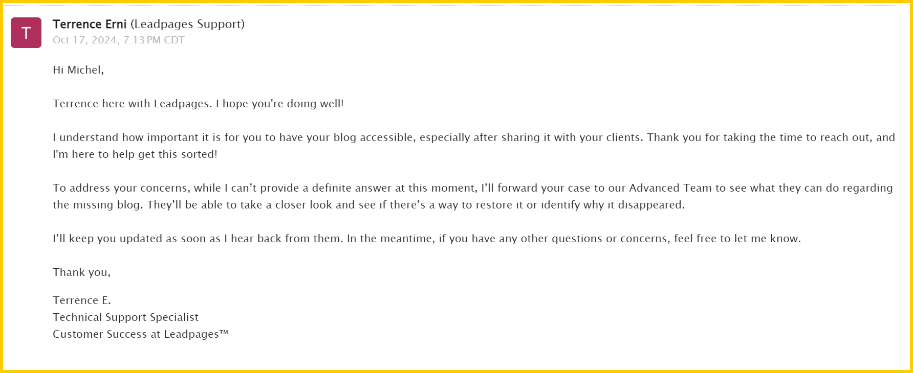
Pff, de Blogs is een nieuwe functie in onze externe landingspagina creater. Werkt nog niet goed, want niemand is er in geweest en de blog is toch weg. Ik schrijf volgende week weer een nieuwe
 .
.Pff, the Blogs is a new feature in our external landing page creator. Doesn't work well yet, because nobody has been in it and the blog is gone anyway. I'll write a new one next week
.Pff, die Blogs sind eine neue Funktion in unserem externen Landingpage-Ersteller. Funktioniert noch nicht so gut, weil noch niemand dabei war und der Blog sowieso weg ist. Ich werde nächste Woche noch einen schreiben
.@Michel-van-Hagen-MRA-Founder bedankt
-
Pff, de Blogs is een nieuwe functie in onze externe landingspagina creater. Werkt nog niet goed, want niemand is er in geweest en de blog is toch weg. Ik schrijf volgende week weer een nieuwe
.Pff, the Blogs is a new feature in our external landing page creator. Doesn't work well yet, because nobody has been in it and the blog is gone anyway. I'll write a new one next week
.Pff, die Blogs sind eine neue Funktion in unserem externen Landingpage-Ersteller. Funktioniert noch nicht so gut, weil noch niemand dabei war und der Blog sowieso weg ist. Ich werde nächste Woche noch einen schreiben
.@Michel-van-Hagen-MRA-Founder :
Hey Michael,
Oh and it was so well described in this new blog, I also saw that only a first blog was there, was already ready to describe my experiences.
So have fun hope you had a copy of the content. Save is save at least the first time

Hey Michael,
Oh und es war so gut beschrieben in diesem neuen Blog, hab es auch gesehen das nur ein erster Blog dort lag, war schon bereit meine Erfahrungen mal zu beschreiben.
Also viel Spaß hoffe Du hattest eine Copy vom Inhalt. Save ist Save zumindest beim ersten mal
-
@Michel-van-Hagen-MRA-Founder Ja, je route eerst copiëren werkt ook maar dan heb ik een copy staan die ik eigenlijk niet wil en achteraf weer dien te verwijderen wegens nutteloos. Dat zijn al een paar klikken meer. Persoonlijk vind ik het veel handiger om de tracklog onderliggend toe te voegen aan een route vooraleer ik aan het optimaliseren van een route begin en deze gelijk trek met de track. Te meer daar ik de track altijd apart doorstuur en deze dus toch nodig heb daar een geïmporteerde track van waar dan ook te veel vereenvoudigd wordt en soms heel vreemde kronkels vertoont. Dus met 1 klik de track hebben en indien mogelijk onmiddellijk zichtbaar te maken in de route waar je mee bezig bent lijkt me super handig. Je moet dan nog enkel de track in de juiste tracklog map plaatsen.
Nu heb je enkel de keuze om de route naar MyDrive (planplan.tomtom) door te sturen. Die route gaat daar heel vaak afwijken van het origineel. De track nooit. Dus daar ook zou het handig zijn om die optie te voorzien.@Guzt Ik begrijp je punt, bedankt. Ik zal het overleggen met de programmeurs of er een 'quick win' mogelijk is, of dat we er echt een project van moeten maken.
“People don’t take trips, trips take people.” – John Steinbeck
-
I am waiting for a response from Leadpages, if that doesn't work I will write a new blog soon.
“People don’t take trips, trips take people.” – John Steinbeck
-
@Michel-van-Hagen-MRA-Founder, Ik zie wel degelijk de meerwaarde van die functie, en misschien zou die zelfs wel vast in een route geïntegreerd moeten worden. Net zoals je een een (goede) GPX zowel de route als de track opslaat.
De meerwaarde van een track bij het opslaan van een route is dat je die kunt gebruiken als referentie voor het controleren of er zaken veranderd zijn aan een route onder invloed van verkeers info, seizoenssluitingen, veranderingen op de kaart zoals nieuwe of aangepaste wegen etc. De witte lijn in de app is een goede stap, maar representeert nog steeds niet de route zoals die aanvankelijk gepland is, maar de route zoals die bij het starten gecalculeerd wordt. Dat is principieel niet hetzelfde.
Ik ben er best wel voor dat bij het openen van een route (of dat nou in Navigation is of in de planner) de optie bestaat om automatisch de onderliggende track in een andere kleur weer te geven. Maar dan moet dat wel een échte track van het moment van plannen vertegenwoordigen.
@Con-Hennekens 100% mee eens! Zou een zeer sterke troef zijn. Ik rij vaak voor en ervaar dit wel degelijk als een gemis.
-
I am waiting for a response from Leadpages, if that doesn't work I will write a new blog soon.
@Michel-van-Hagen-MRA-Founder :
Ich habe eine schöne Mail bekommen das der Blog 'verschwunden' ist ... ja das ist ärgerlich, wie schon geschrieben.
Dabei wird auf das überarbeitete gute Handbuch hingewiesen auch das ist eine sehr gute Idee. Danke dafür denn das ist die Basis allen Wissens in der Wissensdatenbank.
Link zur FehlermeldungBitte doch mal genauer prüfen denn dort sind für mich als Anwender "in Deutscher Sprache" nicht alle Ebenen verfügbar s. dazu diese Fehlermeldung
Gerade für neue Anwender / User sehr ärgerlich da der Text ja vorhanden ist nur der Sprung an die richtige Stelle versagt. Scrollt man runter ist alles sehr gut beschrieben aber ein Klick auf einen Link führt zum Fehler !!
I got a nice email saying that the blog has 'disappeared'... yes, that's annoying, as I've already written.
It points to the revised, good manual, which is also a very good idea. Thank you for that, because that is the basis of all knowledge in the knowledge database.
Please check more closely, because not all levels are available to me as a user "in German", see this error message
Particularly annoying for new users as the text is there but the jump to the right place fails. If you scroll down everything is very well described but clicking on a link leads to an error!
-
@Guzt Ik begrijp je punt, bedankt. Ik zal het overleggen met de programmeurs of er een 'quick win' mogelijk is, of dat we er echt een project van moeten maken.
@Michel-van-Hagen-MRA-Founder dank je wel Michel
-
“People don’t take trips, trips take people.” – John Steinbeck
-
solution approach:
If we gave you the choice for each route (1) "convert to route" or (2) "drive along route", would that be the best of both worlds?
Thank you for that!!!!
I'm looking forward to these two great solutions, they will delight all users, even those who are currently unhappy with the old version of track navigation.
Lösungsansatz:
Wenn wir Ihnen für jede Strecke die Wahl lassen würden (1) „in Route umwandeln“ oder (2) „über Strecke fahren“, wäre das das Beste aus beiden Welten?
Danke dafür !!!!
Ich freue mich schon auf diese zweit super Lösungen, das wird alle User begeistern auch die die im Moment noch unglücklich mit den alten Version beim Track Navigieren sind.
-
Voorstel verbeteren track navigatie; Als we je nou bij elke track de keuze geven (1) 'converteer naar route' of (2) 'rijden via track', zou dat dan het beste uit 2 werelden zijn?
Ja, hier ben ik wel voorstander van. en zeker als de oorspronkelijke track zichtbaar blijft met bijvoorbeeld een rode lijn. Volg je de route en zie je in je scherm dat de route afwijkt van de rode (track) lijn heb je de keuze om de route te volgen, of de rode (track) lijn. -
Ik vind het een beetje raar om te spreken van navigeren via een route of navigeren via een track.
Navigeren is het volgen van een geplande route met duidelijke tussenpunten, viapunten of waypoints, PIO's, ..... noem maar op. Men zoekt doelbewust die punten op en je krijgt ook instructies ( visueel en auditief )Een track of een spoor volgen : ik vergelijk het met een slijmspoor van een slak op de vloer of op je ruiten. Je stippelt die track wel uit, maar je krijgt geen instructies en je kan ervan afwijken zoveel je wil. Je ziet wel steeds hoever je ervan afgeweken bent.Het eindpunt is het enige dat telt.
Een tweede wezenlijk verschil is dat je meet een track ook over wegen kan rijden die niet gekend zijn of herkend worden door Here of TomTom of OSM via hun AI.
Je kan dus gebruik maken van andere kaarten ( ls onderlegger) om af te wijken van een gekende weg.
Met de Zümo XT2 kan je dat perfect uitvoeren en zelfs je trackbreedte instellen.
Je moet enkel de juiste kaart gebruiken, een soort grote PDF of grote foto van een map.Van zodra je een track converteert naar een route is het geen track meer, maar een route met instructies.
BIj Parijs-Dakar worden harde viapunten bepaalt door de organisatie. De weg ertussen moet je zelf zien uit te zoek via bestaande sporen of via eigen oriëntatie.
-
Ik vind het een beetje raar om te spreken van navigeren via een route of navigeren via een track.
Navigeren is het volgen van een geplande route met duidelijke tussenpunten, viapunten of waypoints, PIO's, ..... noem maar op. Men zoekt doelbewust die punten op en je krijgt ook instructies ( visueel en auditief )Een track of een spoor volgen : ik vergelijk het met een slijmspoor van een slak op de vloer of op je ruiten. Je stippelt die track wel uit, maar je krijgt geen instructies en je kan ervan afwijken zoveel je wil. Je ziet wel steeds hoever je ervan afgeweken bent.Het eindpunt is het enige dat telt.
Een tweede wezenlijk verschil is dat je meet een track ook over wegen kan rijden die niet gekend zijn of herkend worden door Here of TomTom of OSM via hun AI.
Je kan dus gebruik maken van andere kaarten ( ls onderlegger) om af te wijken van een gekende weg.
Met de Zümo XT2 kan je dat perfect uitvoeren en zelfs je trackbreedte instellen.
Je moet enkel de juiste kaart gebruiken, een soort grote PDF of grote foto van een map.Van zodra je een track converteert naar een route is het geen track meer, maar een route met instructies.
BIj Parijs-Dakar worden harde viapunten bepaalt door de organisatie. De weg ertussen moet je zelf zien uit te zoek via bestaande sporen of via eigen oriëntatie.
@EMW-motorridders wat er wel en niet kan qua navigeren met een track hangt helemaal af van de app of het apparaat waarmee je navigeert. MRA Navigation en ook andere apps, zoals TomTom Go en apparaten hebben de mogelijkheid om te navigeren o.b.v. een track en geven daarbij wel degelijk ook instructies. Uiteraard niet over onbekende wegen/offroad.
MRA heeft daarnaast inderdaad ook volg-de-lijn navigatie zonder instructies (in de gratis versie).
-
@EMW-motorridders, Je krijgt met een track in de meeste gevallen wel degelijk instructies. Een Zumo of een Rider doen dat toch ook? De (gratis) TomTom Go app app navigeert zelfs uitsluitend met tracks als ik het goed begrepen heb. Het navigeren van tracks is populair geworden vanwege dat deze onderlinge routeringsverschillen met diverse platformen en kaarten nivelleert. Maar er gaat niks boven een goed geplande échte route inderdaad. Er zijn echter zat toercommissarissen (van de oude stempel) die vinden dat ze alleen een track moeten uitdelen, om gezeur te voorkomen...
-
@Herko-ter-Horst met een track kan je niet instructies krijgen want het is een kruimelspoor die niet gekoppeld is aan een kaart. dus als navigatiesoftware je wel instructies geeft is dat een route en hebben ze op de achtergrond track op basis van hun kaarten er een route van gemaakt.
-
For me this blog has slightly answered some of the advantages and disadvantages of Route, Tracks and Track Logs, I'm still not 100% clear how this affects me in my own real world scenario.
I often produce routes in MRA for a tour group which then gets distributed out (by GPX) to other riders just before a trip. The other riders have a range of different Navigation devices including TomTom Rider, Garmin Zumo, TomTomGo etc. I want to be able to provide them with a route, provided to them in the most optimal way that gives them the best experience which closely follows the route as originally intended. The reality is that while riding the route others follow different instructions that there device has told them to take and they end up getting lost. My Solution to this is to provide them with the stop locations (location name and What3Words ref) and telling them 'if you get lost, abandon the route and navigate to the stop location so we can regroup'.
Could there be a table provided in the 'Manuals' listing the different devices showing the critical steps necessary to make sure they end up with the optimal route which then allows them to be confident that they will follow the same route as it was originally designed on MRA Planner.
While GPX file is the most convenient method of route distribution I appreciate it most probably doesn't provide the best experience for all the different devices being used.
Many thanks
David RudgleyMRA Gold Planner + App + Navigation Next user
Android Pixel 9 Pro XL
TomTomGo as backupKTM 1290 Super Adventure S
Quad Lock + Phone +Carpuride W702KTM 790 Duke
Quad Lock + Phone -
@Herko-ter-Horst met een track kan je niet instructies krijgen want het is een kruimelspoor die niet gekoppeld is aan een kaart. dus als navigatiesoftware je wel instructies geeft is dat een route en hebben ze op de achtergrond track op basis van hun kaarten er een route van gemaakt.
@Bouke-Ent waarom zou je geen instructies kunnen krijgen? Dat hangt zoals gezegd helemaal af van de software/app/het apparaat dat je gebruikt. MRA Navigation en TomTom Go werken gewoon op tracks, TomTom inderdaad zelfs uitsluitend.
Een route is ook alleen maar een reeks GPS-coordinaten, die niet gekoppeld zijn aan een kaart. Het gaat om de interpretatie daarvan door de navigatiesoftware/-app/-apparaat.
-
@Herko-ter-Horst met een track kan je niet instructies krijgen want het is een kruimelspoor die niet gekoppeld is aan een kaart. dus als navigatiesoftware je wel instructies geeft is dat een route en hebben ze op de achtergrond track op basis van hun kaarten er een route van gemaakt.
@Bouke-Ent, hoe kom je daar nu bij?
Hoe navigeer jij zelf eigenlijk? -
For me this blog has slightly answered some of the advantages and disadvantages of Route, Tracks and Track Logs, I'm still not 100% clear how this affects me in my own real world scenario.
I often produce routes in MRA for a tour group which then gets distributed out (by GPX) to other riders just before a trip. The other riders have a range of different Navigation devices including TomTom Rider, Garmin Zumo, TomTomGo etc. I want to be able to provide them with a route, provided to them in the most optimal way that gives them the best experience which closely follows the route as originally intended. The reality is that while riding the route others follow different instructions that there device has told them to take and they end up getting lost. My Solution to this is to provide them with the stop locations (location name and What3Words ref) and telling them 'if you get lost, abandon the route and navigate to the stop location so we can regroup'.
Could there be a table provided in the 'Manuals' listing the different devices showing the critical steps necessary to make sure they end up with the optimal route which then allows them to be confident that they will follow the same route as it was originally designed on MRA Planner.
While GPX file is the most convenient method of route distribution I appreciate it most probably doesn't provide the best experience for all the different devices being used.
Many thanks
David Rudgley@davidrudgley-net said in Navigating with a track or navigating with a route?:
While GPX file is the most convenient method of route distribution I appreciate it most probably doesn't provide the best experience for all the different devices being used.
As far as I know GPX is the only common and generic method of sharing routes. What it does not share however is route optimization and routing settings that ere used in the planner (things like quickest or shortest, no highways, no unpaved roads). That means that calculation of the route depends on the settings on the device itself. Many people forget that, and even "official" tour planners forget to share that information, making it very difficult for riders to re-calculate the route the same way it was planned.
Besides that, a GPX can contain many things: routes, waypoints, POI and tracks, all in the same file.
I am just an enthusiastic MRA user, and hope you will be one too!
Most motorcycle problems are caused by the nut that connects the handlebar to the saddle.
Check out RideSleepRepeat.eu, a biker community for sharing stays across Europe
-
@Bouke-Ent waarom zou je geen instructies kunnen krijgen? Dat hangt zoals gezegd helemaal af van de software/app/het apparaat dat je gebruikt. MRA Navigation en TomTom Go werken gewoon op tracks, TomTom inderdaad zelfs uitsluitend.
Een route is ook alleen maar een reeks GPS-coordinaten, die niet gekoppeld zijn aan een kaart. Het gaat om de interpretatie daarvan door de navigatiesoftware/-app/-apparaat.
@Herko-ter-Horst said in Navigating with a track or navigating with a route?:
@Bouke-Ent waarom zou je geen instructies kunnen krijgen? Dat hangt zoals gezegd helemaal af van de software/app/het apparaat dat je gebruikt. MRA Navigation en TomTom Go werken gewoon op tracks, TomTom inderdaad zelfs uitsluitend.
Een route is ook alleen maar een reeks GPS-coordinaten, die niet gekoppeld zijn aan een kaart. Het gaat om de interpretatie daarvan door de navigatiesoftware/-app/-apparaat.
je kan het ook zo zien.
ik zie een track als een kruimelspoor die overal kan lopen ook waar geen wegen zijn. een route is in mijn beleving iets waar langs je navigeer de punten die volg je dan. het navigatie systeem maak er dan op basis van een kaart er instructies van. ik heb ook een tomtom 500 en die werkt niet met een track. in mijn geval gaat mydrive of de 500 zelf proberen er een route van te maken met alleen vormingspunten. zit er dan bv een stukje offroad of fietspad tussen dan krijg ik een omweg. mijn zumo doet het zelfde.
misschien bedoelen we het zelfde maar praten we even langs elkaar.
-
@Herko-ter-Horst said in Navigating with a track or navigating with a route?:
@Bouke-Ent waarom zou je geen instructies kunnen krijgen? Dat hangt zoals gezegd helemaal af van de software/app/het apparaat dat je gebruikt. MRA Navigation en TomTom Go werken gewoon op tracks, TomTom inderdaad zelfs uitsluitend.
Een route is ook alleen maar een reeks GPS-coordinaten, die niet gekoppeld zijn aan een kaart. Het gaat om de interpretatie daarvan door de navigatiesoftware/-app/-apparaat.
je kan het ook zo zien.
ik zie een track als een kruimelspoor die overal kan lopen ook waar geen wegen zijn. een route is in mijn beleving iets waar langs je navigeer de punten die volg je dan. het navigatie systeem maak er dan op basis van een kaart er instructies van. ik heb ook een tomtom 500 en die werkt niet met een track. in mijn geval gaat mydrive of de 500 zelf proberen er een route van te maken met alleen vormingspunten. zit er dan bv een stukje offroad of fietspad tussen dan krijg ik een omweg. mijn zumo doet het zelfde.
misschien bedoelen we het zelfde maar praten we even langs elkaar.
@Bouke-Ent said in Navigating with a track or navigating with a route?:
ik zie een track als een kruimelspoor die overal kan lopen ook waar geen wegen zijn.
Dat is het ook, maar dat betekent nog niet dat daar geen instructies mogelijk zijn. Daar waar geen wegen zijn krijg je inderdaad geen instructies. Maar volgens mij zijn er ook off-road systemen die wèl gewoon instructies geven, speciaal aangepast aan off-road rijden. Ook jouw zumo rijdt gewoon een track zonder vormingspunten als je de track hebt geconverteerd naar trip. Zet hercalculatie maar eens aan en rij van de track af, dan pas maakt-ie er een route van (naar het eind...)
Hello! It looks like you're interested in this conversation, but you don't have an account yet.
Getting fed up of having to scroll through the same posts each visit? When you register for an account, you'll always come back to exactly where you were before, and choose to be notified of new replies (either via email, or push notification). You'll also be able to save bookmarks and upvote posts to show your appreciation to other community members.
With your input, this post could be even better 💗
Register Login-
013215
-
0331
-
3485
-
014226
-
07141
-
0234
-
7201.3k
-
06170