Route ignores obvious left turn
-
Greetings,
I am a seasoned Garmin BaseCamp/Zumo XT user but just started with MRA using a Basic account. I did this in order to generate routes while on a trip using my iPad if for some reason my original plans change. This happened last fall when our route took us into areas with heavy forest fire smoke. We canceled our original trip plans and headed the other direction. I created new routes directly on the Zumo which was cumbersome to say the least. I like what I'm seeing so far with MRA and can envision moving to it exclusively as I get more experience with it.
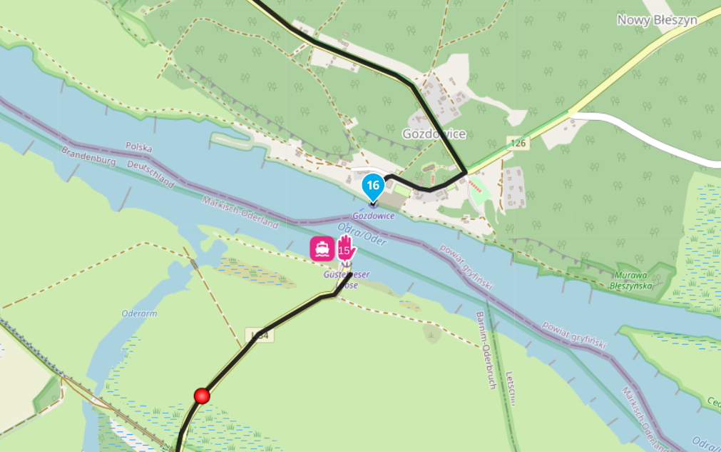
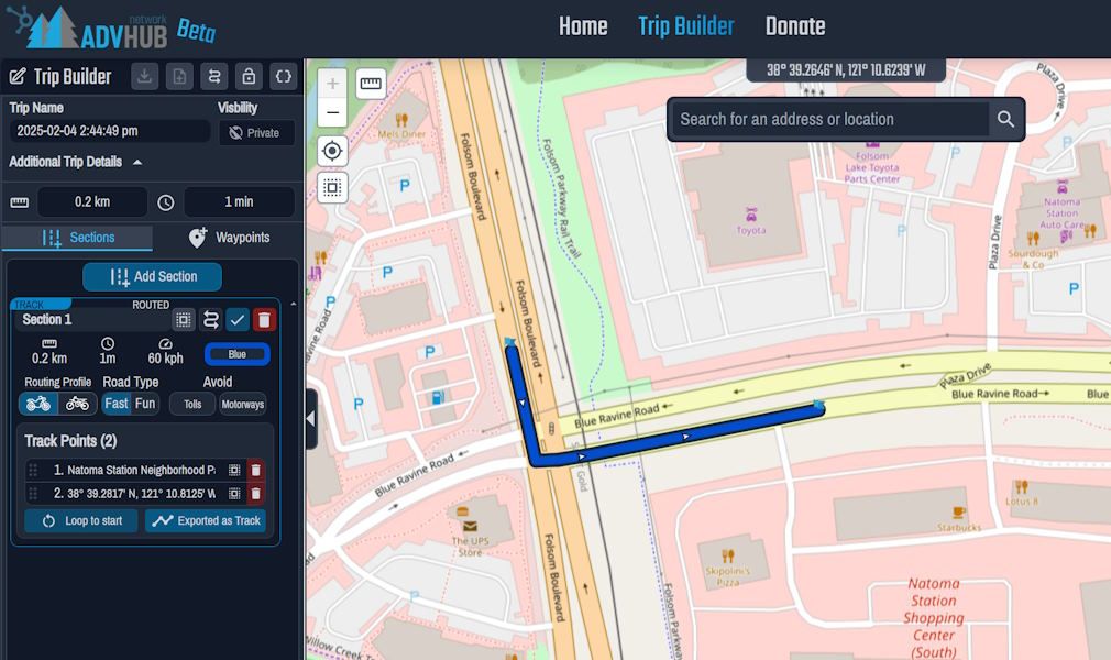
I created a day trip on my iPad and found a situation where MRA would not follow the obvious road. Even when I added shaping points (locations shown by red dots between shaping points 5 and 6) it created convoluted paths to get to them but not follow the simplest, most direct route. It doesn't seem likely this is a map choice problem, that is the free OSM vs. the subscription HERE map. Could it just be an error in the OSM map? My only avoidance is unpaved roads. BTW, this route loaded into the Zumo makes the correct turn as you would expect between the two shaping points.
Tom
-
This seems to be a problem with the OSM map. If I change the standard map from OSM to Here or Tomtom, the route works as expected. However, changing from OSM to Here/Tomtom is only possible in the Gold version.
-
As @Mopetenpit said, the Here maps seems to work fine, so presume it's an issue with OSM
-
I don't think it's because of the OSM data.
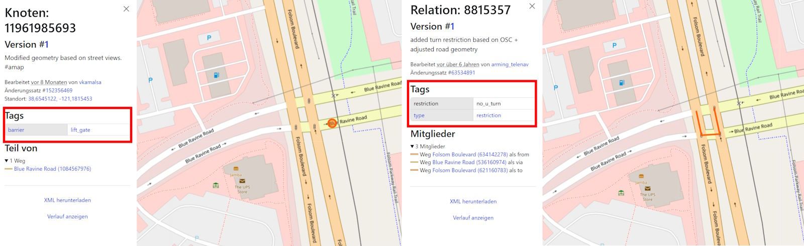
There are two potential limitations: A railway barrier and a U-turn restriction, but neither should prevent a left turn:
Other planning programmes based on OSM allow this:
This is probably due to the route engine (API) MRA uses.
-
Thanks all for the quick replies. A map problem was my conclusion, too. I've made that left turn many times and there are no restrictions.
Is there a means to report this problem? In the past I've done so with Garmin's maps.
Tom
-
Answered this last question by creating an OSM account and posting a note at that location.
-
Answered this last question by creating an OSM account and posting a note at that location.
@twinfan said in Route ignores obvious left turn:
posting a note at that location.
What exactly do you mean by that?
-
OSM provides for problem reporting and map fixes. I made this note:

-
OSM provides for problem reporting and map fixes. I made this note:
@twinfan said in Route ignores obvious left turn:
OSM provides for problem reporting and map fixes.
I know. But what exactly causes the problem, in your opinion, and what should be changed or corrected?
As mentioned above, other planners based on OSM allow a left turn, so it's not an OSM Map issue. Do you disagree? -
@Martin-Wilcke said in Route ignores obvious left turn:
I know. But what exactly causes the problem, in your opinion, and what should be changed or corrected?
As mentioned above, other planners based on OSM allow a left turn, so it's not an OSM Map issue. Do you disagree?From what I read in the earlier posts the HERE and TomTom maps route correctly when selected. So does the Garmin City Navigator North America NT 2025.2 map on my Zumo XT. I think it is a problem with the OSM map but I have no idea how one would fix it.
-
@Martin-Wilcke said in Route ignores obvious left turn:
I know. But what exactly causes the problem, in your opinion, and what should be changed or corrected?
As mentioned above, other planners based on OSM allow a left turn, so it's not an OSM Map issue. Do you disagree?From what I read in the earlier posts the HERE and TomTom maps route correctly when selected. So does the Garmin City Navigator North America NT 2025.2 map on my Zumo XT. I think it is a problem with the OSM map but I have no idea how one would fix it.
@twinfan said in Route ignores obvious left turn:
I think it is a problem with the OSM map but I have no idea how one would fix it.
I have taken a closer look at this spot.
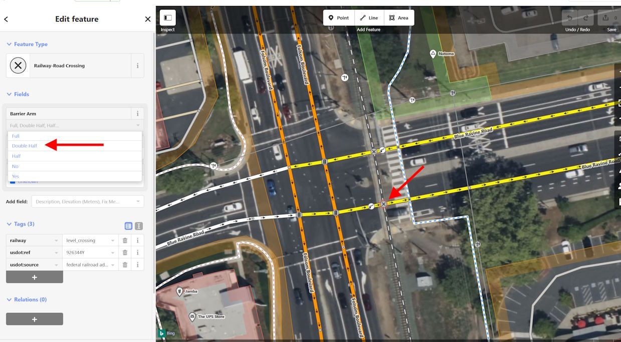
The issue is probably caused by an extra barrier:lift_gate entry in addition to the railway:level_crossing. In my opinion, this is wrong.
I've added this to your comment, let's see if a mapper with local knowledge makes a change there.
-
Thank you, @Martin-Wilcke . I was contemplating learning more about OSM editing but it is very complex and I wouldn't want to make things worse.
-
I also thought it odd that there were signals shown in only three of the four corners but, then again, I don't understand the mapping "language."
 image url)
 -
I also thought it odd that there were signals shown in only three of the four corners but, then again, I don't understand the mapping "language."
@twinfan said in Route ignores obvious left turn:
I don't understand the mapping "language."
Here is an overview of all valid keys, their values, meaning and examples:
https://wiki.openstreetmap.org/wiki/Map_features
Search for railway:level_crossing and barrier:lift_gate; these are the key types related to this issue.
It is worth familiarising yourself with the different categories because there is an extra bonus: you can search for OSM POIs in a given area, export them as GPX and import them into MRA. This way, you can create your own POI libraries in MRA. We have discussed an example ("castles in the UK") here:
-
Thank you, @Martin-Wilcke . I was contemplating learning more about OSM editing but it is very complex and I wouldn't want to make things worse.
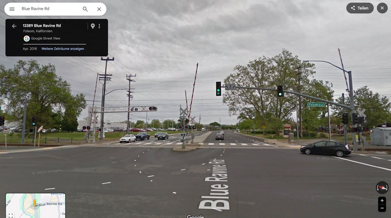
According to Google Street View, there is a railway crossing with two half barrier arms but no extra lift gate (this is the mapping error):
So, I recommend making the following changes (for both directions):
- Delete the lift gate barrier:
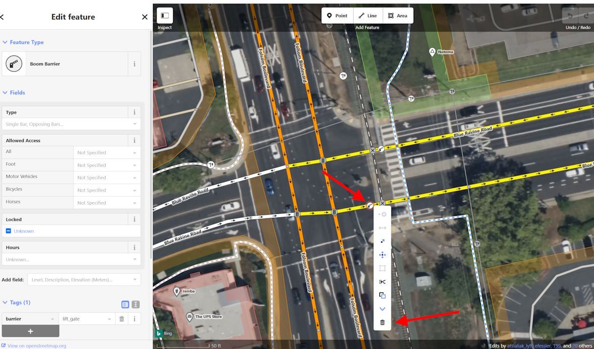
Add the "two-half barrier arm" attribute to the railway crossing:
-
Thank you, @Martin-Wilcke, I will give it a try. I use that intersection regularly, today in fact.
-
I made your recommended changes and checked the box asking for a review from an experience mapper, just in case. I also found another intersection about one mile earlier in the route that had a similar condition and revised it. This explains how MRA chose the route it did on my initial try. Thank you again for your guidance. I enjoyed learning about OSM!
Tom -
Thank you, @Martin-Wilcke, I will give it a try. I use that intersection regularly, today in fact.
-
I made your recommended changes and checked the box asking for a review from an experience mapper, just in case. I also found another intersection about one mile earlier in the route that had a similar condition and revised it. This explains how MRA chose the route it did on my initial try. Thank you again for your guidance. I enjoyed learning about OSM!
Tom@twinfan
It took a loooooong time (probably due to the refresh cycle of the OSM server used by MRA), but it finally works now!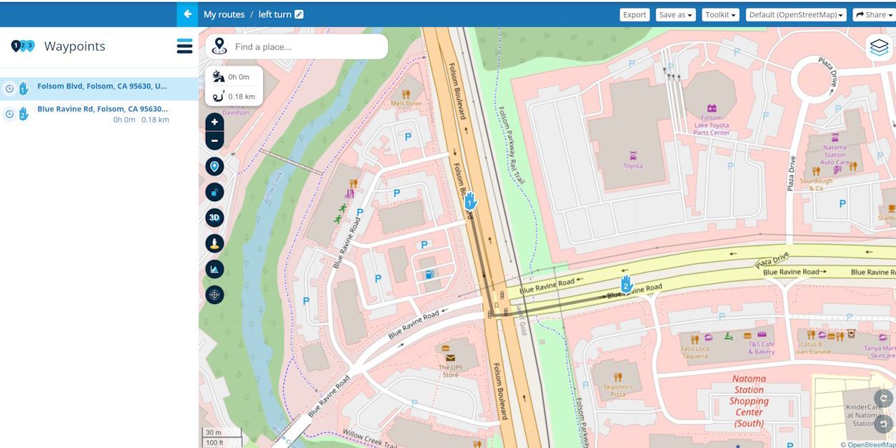
-
@Martin-Wilcke, thanks for checking and nice to see it worked!

Hello! It looks like you're interested in this conversation, but you don't have an account yet.
Getting fed up of having to scroll through the same posts each visit? When you register for an account, you'll always come back to exactly where you were before, and choose to be notified of new replies (either via email, or push notification). You'll also be able to save bookmarks and upvote posts to show your appreciation to other community members.
With your input, this post could be even better 💗
Register Login-
029613
-
014313
-
07118
-
0228
-
04158
-
27392.2k
-
0367
-
1311.8k