GPX Versions 1.1 vs 1.2 for Garmin Visually Explained
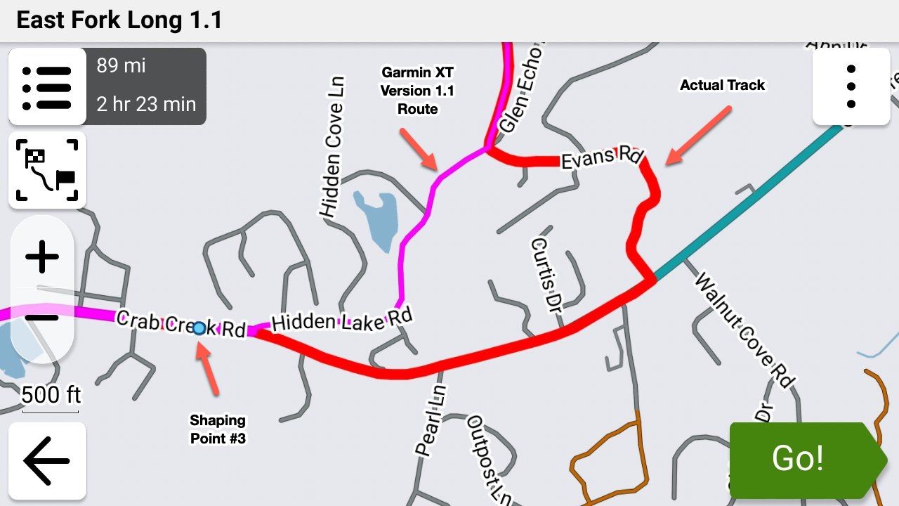
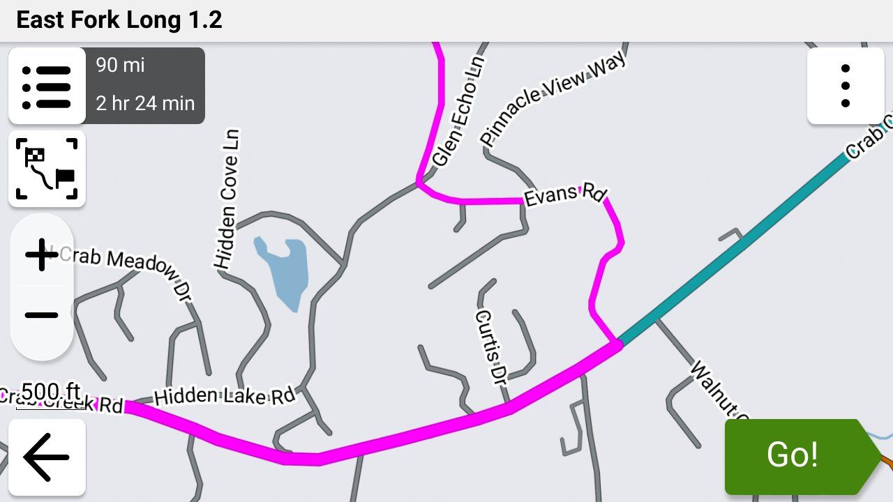
-

I've recently noticed that I can now export a GPX1.2 route from MRA to Tread on my iPhone and subsequently my XT2 (presumably XT3 too) without it being corrupted. I have my track running underneath so I can see that the Zumo does not try to recalculate a different route altogether between via points even when deviating from the route (auto-recalculate switched on). A test route I ran today seemed to prove it where once it would have gone haywire and either routed direct to the via point on a road or even a straight line.
Route deviations seemed to be dealt with in a logical manner, either a u-turn or directions back on to the route up ahead. I didn't encounter any road closures so not sure if they will be dealt with well in the same way 1.1 does (mostly!).
Maybe one of the recent Tread, Zumo or MRA updates has allowed this to happen. No shaping points visible but ultra quick calculations on both sets of software. I'm hoping I've got this right as it's what many have been looking for.
Probably some further testing to come but I'll be keen to see if anyone else has this good fortune.
-
I've recently noticed that I can now export a GPX1.2 route from MRA to Tread on my iPhone and subsequently my XT2 (presumably XT3 too) without it being corrupted. I have my track running underneath so I can see that the Zumo does not try to recalculate a different route altogether between via points even when deviating from the route (auto-recalculate switched on). A test route I ran today seemed to prove it where once it would have gone haywire and either routed direct to the via point on a road or even a straight line.
Route deviations seemed to be dealt with in a logical manner, either a u-turn or directions back on to the route up ahead. I didn't encounter any road closures so not sure if they will be dealt with well in the same way 1.1 does (mostly!).
Maybe one of the recent Tread, Zumo or MRA updates has allowed this to happen. No shaping points visible but ultra quick calculations on both sets of software. I'm hoping I've got this right as it's what many have been looking for.
Probably some further testing to come but I'll be keen to see if anyone else has this good fortune.

@Carl-Lee I'm not sure what's going on, but as I've said before, I personally take Tread and other intermediate apps out of the mix and get down to the basics that I can see and understand.... Directly upload the 1.2 .gpx file via USP to the Garmin's /.gpx folder, import it, then look at the results.
Using the 1.2 format, the Garmin (XT, XT2 or 3) should not be able to (will NOT in my testing) create a route that deviates from the route that you see in MRA as the Garmin route WILL be forced to follow the .gpx file's embeded track's "breadcrumb" to create the route and disregard the Garmin's own routing logic.
If you choose to use Tread, Drive, Basecamp, MRA or any other file transfer method other than a direct USB transfer to copy your .gpx file from your computer's hard drive to your Garmin device's /gpx folder, then you are choosing to accept the ambiguity of not knowing whether or not that the file was properly transferred to the device.
If you can't see that the .gpx file that's located on your local drive was successfully copied to the Garmin's /gpx folder YOU CANNOT know for certain that it has been transferred properly.
Before anyone slams me with "the xyz app has always worked perfectly for me" believe me..... I understand!
Even though you may not be having an issue with your particular configuration and apps (GREAT! keep doing what you're doing!), for anyone who is having issues this is where troubleshooting should begin. Eliminating variables one by one is the first step in troubleshooting a technical problem. Direct transfer of the .gpx file eliminates many of the variables. That's a fact!
-
@steve-jarrell, I agree with all that you wrote and that is what I have previously found to be correct. I either exported a 1.2 file via USB to my SD card or used 1.1 via Tread. Both worked although if you stopped the 1.2 route and re-started it, Tread would probably corrupt it.
I'm aware of how to remove Tread from the mix but I obviously seem to like a problem to solve. As of recently, 1.2 is now playing nicely with Tread so getting a route into my XT2 is a doddle. I know the route is correct because I run the track in red underneath it. The two do not separate and re-routing back is catered for (if you should so wish).
All I'm trying to say is that for those who are either having trouble with Tread or who have binned it but would like to use it, try it again with 1.2. I like the ability to plan with MRA and loading this route when away from home. The SD card option is too fiddly - I don't much fancy dropping it as it has lots of music on it too.
-
@steve-jarrell, I agree with all that you wrote and that is what I have previously found to be correct. I either exported a 1.2 file via USB to my SD card or used 1.1 via Tread. Both worked although if you stopped the 1.2 route and re-started it, Tread would probably corrupt it.
I'm aware of how to remove Tread from the mix but I obviously seem to like a problem to solve. As of recently, 1.2 is now playing nicely with Tread so getting a route into my XT2 is a doddle. I know the route is correct because I run the track in red underneath it. The two do not separate and re-routing back is catered for (if you should so wish).
All I'm trying to say is that for those who are either having trouble with Tread or who have binned it but would like to use it, try it again with 1.2. I like the ability to plan with MRA and loading this route when away from home. The SD card option is too fiddly - I don't much fancy dropping it as it has lots of music on it too.
@Carl-Lee That's very good to know. Thanks for the update!
I understand the "need to solve the puzzle" syndrome very well. I think it's an affliction that some of us have to live with!

And I agree with you completely that showing the track and the route simultaneously on the Garmin is the absolute best way to know for certain that it's taking you the way that you wanted to go. I learned the hard way to do that (many times) before 1.2 when I had to force it to follow my desired route with a LOT of shaping points.
-
@Carl-Lee I'm not sure what's going on, but as I've said before, I personally take Tread and other intermediate apps out of the mix and get down to the basics that I can see and understand.... Directly upload the 1.2 .gpx file via USP to the Garmin's /.gpx folder, import it, then look at the results.
Using the 1.2 format, the Garmin (XT, XT2 or 3) should not be able to (will NOT in my testing) create a route that deviates from the route that you see in MRA as the Garmin route WILL be forced to follow the .gpx file's embeded track's "breadcrumb" to create the route and disregard the Garmin's own routing logic.
If you choose to use Tread, Drive, Basecamp, MRA or any other file transfer method other than a direct USB transfer to copy your .gpx file from your computer's hard drive to your Garmin device's /gpx folder, then you are choosing to accept the ambiguity of not knowing whether or not that the file was properly transferred to the device.
If you can't see that the .gpx file that's located on your local drive was successfully copied to the Garmin's /gpx folder YOU CANNOT know for certain that it has been transferred properly.
Before anyone slams me with "the xyz app has always worked perfectly for me" believe me..... I understand!
Even though you may not be having an issue with your particular configuration and apps (GREAT! keep doing what you're doing!), for anyone who is having issues this is where troubleshooting should begin. Eliminating variables one by one is the first step in troubleshooting a technical problem. Direct transfer of the .gpx file eliminates many of the variables. That's a fact!
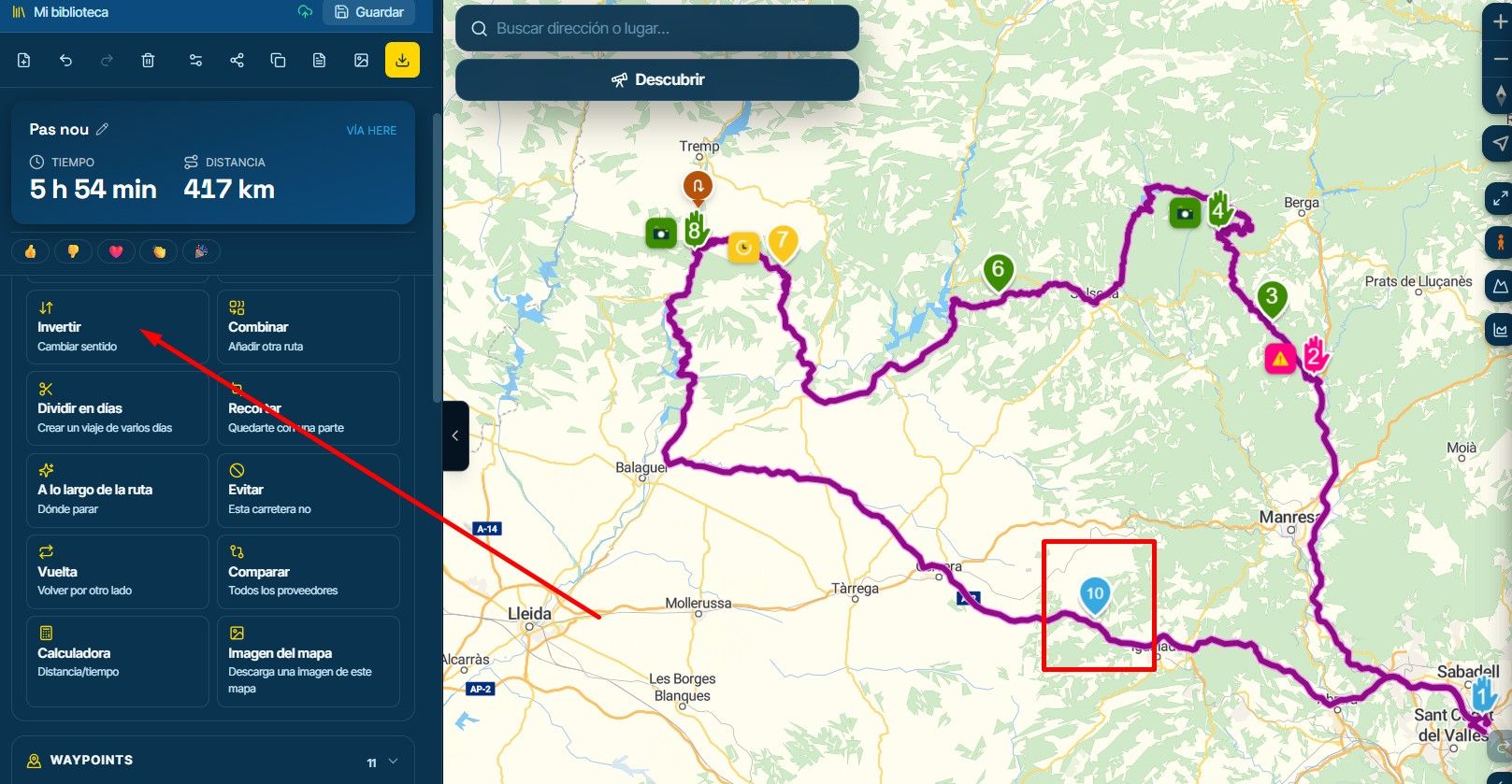
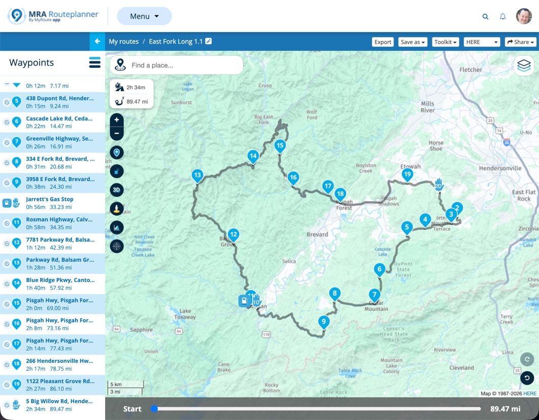
@Steve-Jarrell I finally got around to playing with 1.2, and I'm impressed. Here is a screenshot of one of the most troublesome routes I've recently created, and it passed my 1.2 test perfectly:
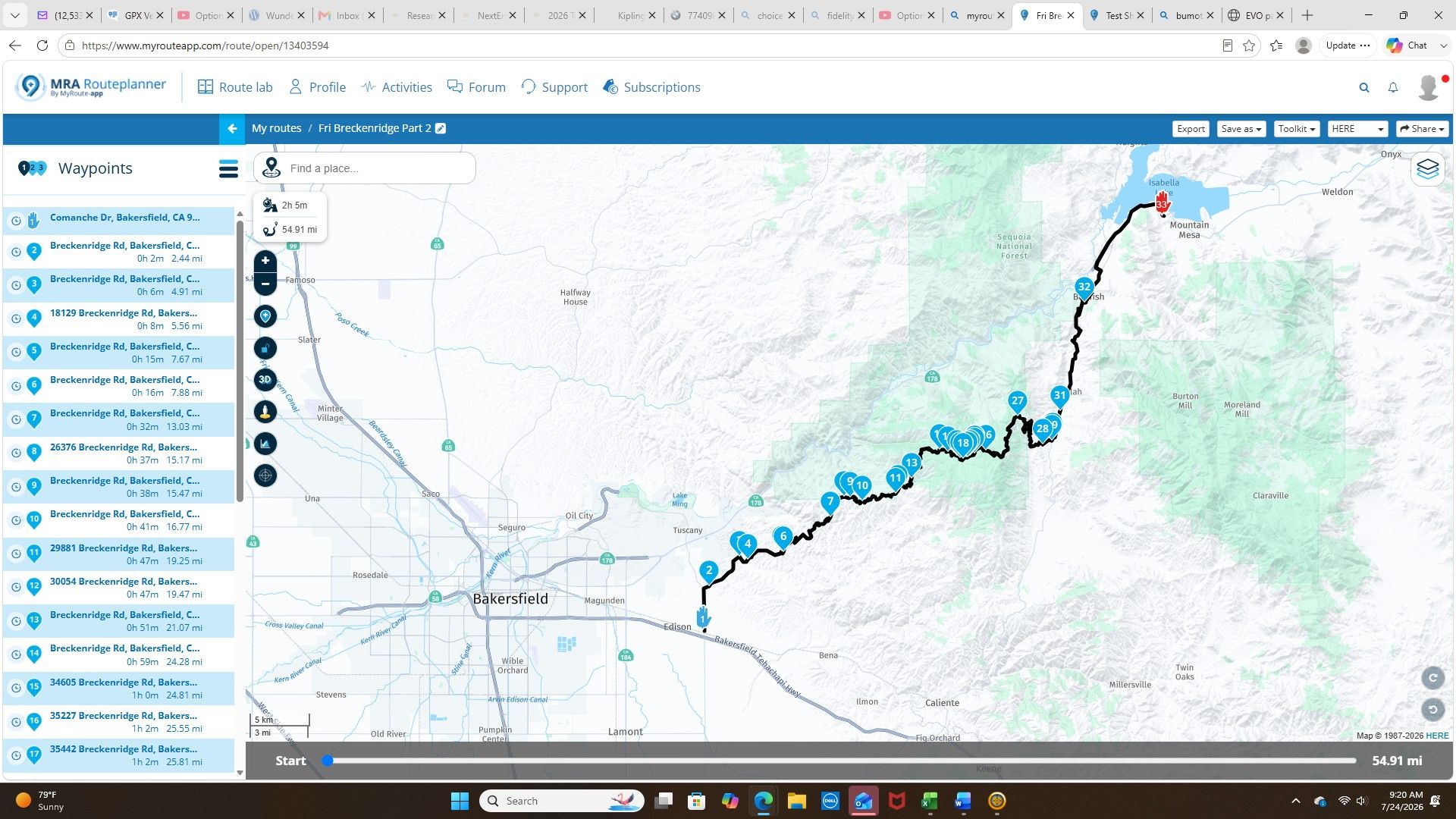
It's a single very rural road that partially crosses the southernmost Sierra Nevada. It's a challenging road to route because it requires precisely positioned shaping points (using 1.1) to Import into a Garmin. I probably have more overall shaping points than needed, but 2 WPs in particular (23&24), as they are exactly placed, are absolutely necessary. It's a unique jog on the road that messes up recalculation on my Zumo otherwise.
Initially, it took a lot of iterative back-and-forth between MRA and my Zumo to finally solve the puzzle. I literally spend hours playing with different shaping point scenarios before solving the mystery. Now with 1.2, I can delete WPs 23&24 and the route recalculates on the Zumo correctly. I'm finally going to able to achieve "what you see on MRA is what you get in the Zomo".
1.2 is definitely going to make life easier for trickier situations like this.
-
@Steve-Jarrell I finally got around to playing with 1.2, and I'm impressed. Here is a screenshot of one of the most troublesome routes I've recently created, and it passed my 1.2 test perfectly:
It's a single very rural road that partially crosses the southernmost Sierra Nevada. It's a challenging road to route because it requires precisely positioned shaping points (using 1.1) to Import into a Garmin. I probably have more overall shaping points than needed, but 2 WPs in particular (23&24), as they are exactly placed, are absolutely necessary. It's a unique jog on the road that messes up recalculation on my Zumo otherwise.
Initially, it took a lot of iterative back-and-forth between MRA and my Zumo to finally solve the puzzle. I literally spend hours playing with different shaping point scenarios before solving the mystery. Now with 1.2, I can delete WPs 23&24 and the route recalculates on the Zumo correctly. I'm finally going to able to achieve "what you see on MRA is what you get in the Zomo".
1.2 is definitely going to make life easier for trickier situations like this.
@John-S-Parry Yep, the concept behind 1.2 is brilliant.... include the track inside of the route information so that the Garmin has no choice but to follow it. I used to have to also include a LOT of shaping points to make my Garmin calculate its route match MRA's route, but no more!
Thanks for the information!!
-
I have been reading up on all of your post and trying to lean as much as possible.
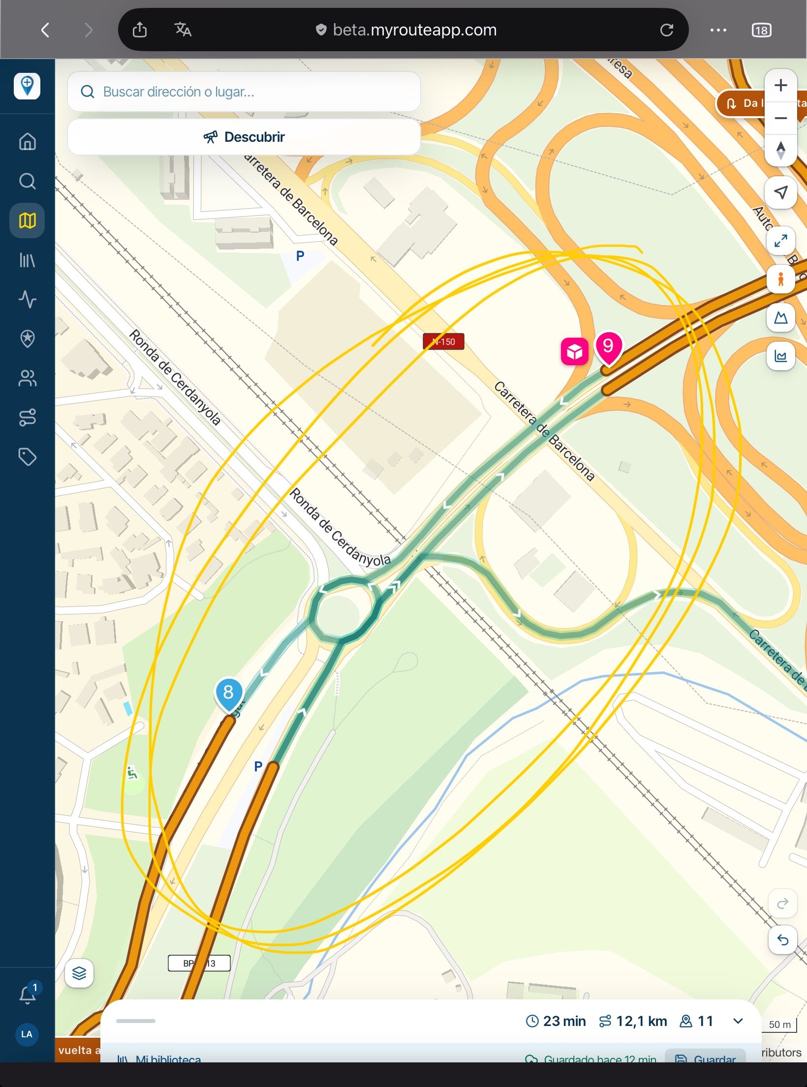
I created a route with all via points and when I set off it did not take me to via point 2 which is just a couple of hundred meters down the road from point 1, It kept trying to send me back to via point 1. Attached is a foto of the firts waypoints. Any help would be much appreciated. I saved the route as 1.2.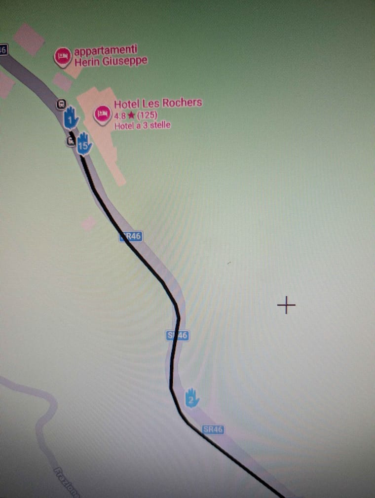
-
I have been reading up on all of your post and trying to lean as much as possible.
I created a route with all via points and when I set off it did not take me to via point 2 which is just a couple of hundred meters down the road from point 1, It kept trying to send me back to via point 1. Attached is a foto of the firts waypoints. Any help would be much appreciated. I saved the route as 1.2.
@Simon-James-Hancock It is always advisable to position the first waypoint 100+ metres from the actual start point, this ensures that the first point is registered as being passed. You were being directed back because the first point was missed.
-
Thanks Nick for all of your help and work.
Even when I passed the second via point it was sending me back to the first.
Will it always try and send me back to the first via poin regardless on how far down the route i am?
I would like to upload my GPX file for further inspection but I am still not allowed. -
Thanks Nick for all of your help and work.
Even when I passed the second via point it was sending me back to the first.
Will it always try and send me back to the first via poin regardless on how far down the route i am?
I would like to upload my GPX file for further inspection but I am still not allowed.
@Simon-James-Hancock Yes, you’ll always be sent back to missed via points, via points are never automatically skipped you would need to manually skip a missed via point.
-
How do I manually skip a missed via point.
In the situation I found myself was their anyway I could have carried on my route without having had to go back to the first via point? -
@Simon-James-Hancock It is always advisable to position the first waypoint 100+ metres from the actual start point, this ensures that the first point is registered as being passed. You were being directed back because the first point was missed.
@Nick-Carthew Exactly. I think we all learn that the hard way!
-
How do I manually skip a missed via point.
In the situation I found myself was their anyway I could have carried on my route without having had to go back to the first via point?
@Simon-James-Hancock Refer to this help page for this answer and many others...
"When navigating, you can skip a waypoint by clicking on the next waypoint (top right button - screen 4). When pressing briefly, you must confirm the choice; when pressed for a long time, it is skipped immediately;
You can also skip multiple waypoints by going to the list of waypoints (three dots at the bottom right - screen 4) and clicking on the waypoint where the navigation should go directly;
Just like when starting up, you can also hold down the waypoint/point on the route line during navigation on the map to navigate directly there." -
My route is saved as 1,2 and all od my points are via points.
I do not see the top right button. -
My route is saved as 1,2 and all od my points are via points.
I do not see the top right button.
@Simon-James-Hancock I'm sorry.... I wasn't thinking. Those instructions are for the MRA app, not the Garmin. I need to pay closer attention!!
As @nick-carthew said, ideally you will avoid this situation by placing your starting location at least a couple of hundred yards/meters beyond where you actually want to start and that way you'll always past through your starting point. That will completely eliminate this issue in the future.
However, as a workaround you can try this.....
When you press "Go" to start a route in the Garmin, you're given three options as to where you want to start..... The beginning point, closest point (shaping point) or the destination. You had no doubt selected the beginning point and as far as I know there's no way to skip that once you've told the Garmin to go there
Since you don't have any shaping points in your route to select as your "closest" point, I THINK in this situation the only way to skip the beginning point if you had entered the route beyond it would be to stop the route in the Garmin, re-enter it and when asked where you want to start tell it the destination.
I'm not 100% sure that would work but I just created a test route of a couple of hundred miles from my house without any shaping points in MRA, saved the route in 1.2 format and imported it into my Garmin XT3 and told the Garmin to make the starting point the destination, and it followed my planned 1.2 route exactly as it was shown in MRA, so I'm fairly certain that will work.
I thought about suggesting turning off auto-recalculation, but since your starting point is a via point and you've told the Garmin that's where you want to start, I don't think that's going to work.
I'm sure there are others here with far more experience with MRA and Garmin than I have, so if there are other methods I'm sure they'll let us know and we'll all learn something new!
-
How do I manually skip a missed via point.
In the situation I found myself was their anyway I could have carried on my route without having had to go back to the first via point?
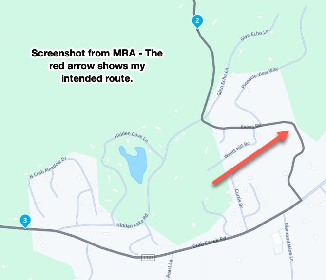
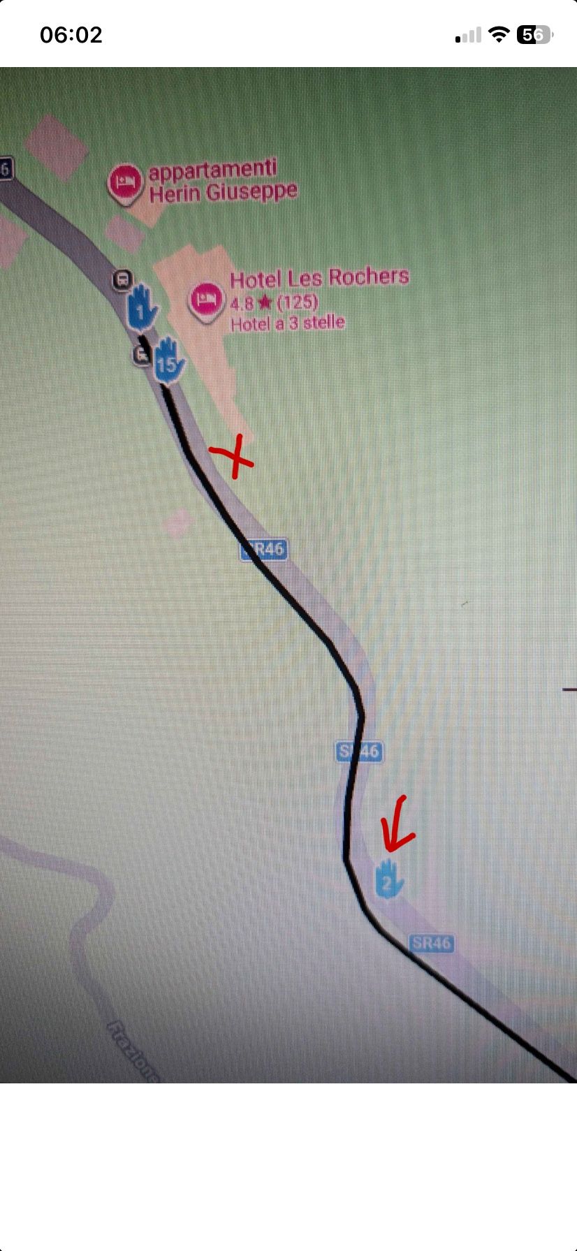
@Simon-James-Hancock I think @steve-jarrell has explained how to deal with a missed via point on a Garmin device. But to be clear about the positioning of your first waypoint. I’m not familiar with the hotel where the route starts from, but let’s say that you leave from where I have placed the red cross, this is clearly in front of waypoint 1 which is why you are sent back. Better to position the start point where waypoint 2 is.
Always willing to help if I can.
Triumph Tiger 1200 XRT called Tina.
MRA Navigation Next and SilverFox BJ8 -
@Simon-James-Hancock I think @steve-jarrell has explained how to deal with a missed via point on a Garmin device. But to be clear about the positioning of your first waypoint. I’m not familiar with the hotel where the route starts from, but let’s say that you leave from where I have placed the red cross, this is clearly in front of waypoint 1 which is why you are sent back. Better to position the start point where waypoint 2 is.
@Nick-Carthew Yes, and I would add for @simon-james-hancock's information.... there's absolutely no need for the Waypoint 2 (via point) in this route. A via point means to MRA and to the Garmin unit "I really want to stop here or go past this particular point", and that's clearly not the intent in this route.
If you're trying to force the route in a certain direction you should use a shaping point, not a via point. If you need help in understanding the differences there are a LOT of really good threads here, and help documents here that explain the differences and their pros and cons.
The bottom line is that this is a self-inflicted problem (I'm not criticizing.... I've done it myself) that can easily be avoided as @nick-carthew pointed out by the proper placement of the starting via point, and the proper use of via points vs shaping points.
The question shouldn't be "How do I skip my initial starting point after I skipped it?" but rather "Where should I place my initial starting point to avoid navigation issues?".
-
The Hotel is my place where I started from. I will Place the start point where via point 2 is and try that.
After having read many of your articles on the subject I came to the conclusion that in order to make sure that the route passes over a certain section you have to use via points and that shaping points can be skipped by the navigation device. If I want to put a petrol station on the route for reference but mot necessarily to stop do I make it a via point or a shaping point?
Thanks for the help. -
I have also only placed the points I want to stop at as via points and changed all the others as shaping points. I will give it a go this afternoon.
-
Ok , I have just come back from a test ride where I had one Garmin xt and one Garmin xt2 connected to the bike.
On the Xt i loaded 1.1 file and the Xt2 a 1.2 file Obviuosly both the same route.
Both routes had the first and last points as via points and all the others were shaping points.
After placing the first via point further down the road from where I started both units came up immediatly with a messag if I wanted to recalculta the route. I said no to both of them. As soon as i reached the first via points both units navigated successfully my loaded route.
However when I stopped and turned the bike off and the units off for a drink at a bar on the route and then turned them back on again I had problems carrying on back along the route. I have to point out that the route is an out and return along the same road.
Any suggestions on how to get back on the route after stopping?
Hello! It looks like you're interested in this conversation, but you don't have an account yet.
Getting fed up of having to scroll through the same posts each visit? When you register for an account, you'll always come back to exactly where you were before, and choose to be notified of new replies (either via email, or push notification). You'll also be able to save bookmarks and upvote posts to show your appreciation to other community members.
With your input, this post could be even better 💗
Register Login








-
 0829
0829
-
 01336
01336
-
0622
-
 01039
01039
-
912612.2k
-
 0521
0521
-
 04133
04133
-
 0517
0517