GPX Versions 1.1 vs 1.2 for Garmin Visually Explained
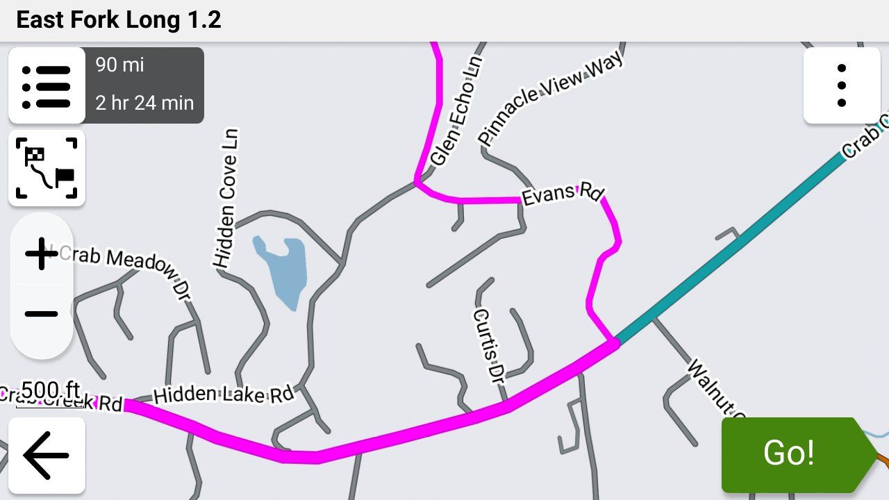
-

That's already checked and I managed to configure the skip next point button on my map screen of my XT2.
-
Ok I have just managed to find the Skip option on my Xt2 under edit. I also made my tracke wide and yellow to make it visible when navigating.
I am trying to get the hang of this before I take the wife on the bike to Marocco in September. The My Route app is fantastic for planning everything. I just don't want to be faffing around trying to find out what to do when I am there.I have a friend coming with his Nissan pickup and I will give him my XT. He is even less of an expert than me and I was thinking of loading just a track for him to follow, to make it easier if we get seperated.
As I will not be connecting the Garmin to my phone or headset I could just use a track too, what do you think?Simon-James-Hancock said in GPX Versions 1.1 vs 1.2 for Garmin Visually Explained:
g


@Simon-James-Hancock Personally in that situation I would just put the beginning and ending via points in the route and then put as many shaping points in as necessary to make the route go where you want it to go, then export it in 1.2 format and use it in both units. By doing so you basically have a track within the route that the Garmin is forced to follow.
Here's what I verified today with my XT3 and 595. I do have auto recalculate turned off on both units.
The problem with multiple via points is that if you do tell the Garmin to skip one, it uses its own logic to recalculate the entire route from via point to via point. On two different GPSs that's almost certainly going to give you two different routes.
On the XT3, when you begin your route, if you tell it to start at one of your via points it will start at that point and follow the remainder of your route as you planned it.
On the 595 when you start at a different via point than the beginning it behaves the same way that skipping a via point does and recalculates the entire route.
Confused yet?? This is very inconsistent but it's the way it works right now.
Bottom line??? Here are your options IMO.
-
As I said with two Garmin units, turn auto recalculate off, just use beginning and ending via points and shaping points as necessary to form your route the way that you want it and use the 1.x format.
-
Just follow a track, but this doesn't give you turn by turn instruction and it's very distracting to have to be constantly watching the screen for directions.
-
Export the track, then once it's imported into the Garmin have the Garmin create a route from it. I really don't think that this is going to be any different from my first suggestion above though.
The other thing that I would HIGHLY recommend if you're going to be traveling with someone in a separate vehicle is to get a pair of Cardo (or similar) communicators so that you can talk back and forth. For your friend in the truck you'd have to rig up some type of wired earbuds or an external speaker and rig up way for him to use the microphone but IMO it would be WELL worth it.
-
-
Ok , I have just come back from a test ride where I had one Garmin xt and one Garmin xt2 connected to the bike.
On the Xt i loaded 1.1 file and the Xt2 a 1.2 file Obviuosly both the same route.
Both routes had the first and last points as via points and all the others were shaping points.
After placing the first via point further down the road from where I started both units came up immediatly with a messag if I wanted to recalculta the route. I said no to both of them. As soon as i reached the first via points both units navigated successfully my loaded route.
However when I stopped and turned the bike off and the units off for a drink at a bar on the route and then turned them back on again I had problems carrying on back along the route. I have to point out that the route is an out and return along the same road.
Any suggestions on how to get back on the route after stopping?
@Simon-James-Hancock The easiest solution to this issue isn't using multiple via points as they will cause unwanted rerouting issues if you skip them even if you have auto recalculation turned off as I've documented.
Instead, try this....
When you turn the power off on the bike the GPS will lose power and will begin a countdown before it turns off. Cancel the shutdown. Then you can quickly press the on/off button and it will go into standby mode. When you power it back up it will be in exactly the same state as it was when you turned the bike off.
-
Ok I have just managed to find the Skip option on my Xt2 under edit. I also made my tracke wide and yellow to make it visible when navigating.
I am trying to get the hang of this before I take the wife on the bike to Marocco in September. The My Route app is fantastic for planning everything. I just don't want to be faffing around trying to find out what to do when I am there.I have a friend coming with his Nissan pickup and I will give him my XT. He is even less of an expert than me and I was thinking of loading just a track for him to follow, to make it easier if we get seperated.
As I will not be connecting the Garmin to my phone or headset I could just use a track too, what do you think?Simon-James-Hancock said in GPX Versions 1.1 vs 1.2 for Garmin Visually Explained:
g
@Simon-James-Hancock "As I will not be connecting the Garmin to my phone or headset I could just use a track too, what do you think?"
I missed this part before. The issue with a track is that you have to really be watching your GPS constantly as you don't have any turn-by-turn instructions, and especially being in a foreign country and not knowing the roads I wouldn't feel comfortable with that.
I would absolutely have the voice commands coming to my helmet, and as I mentioned in my last post I would also have a means to be communicating with the other person that's following you.
-
As far as I can tell, gpx1.2 from MRA removes shaping points (in Garmin speak), but includes route point extensions. Those are generated as the result of routing calculations. They are in the same locations as track points would be if you exported a track generated from the route. Route point extensions are ignored on route recalculation however. That means an imported gpx 1.2 route will look just fine on import, but if it is recalculated, only the via points(Via points,stopping points known as Waypoints in Garmin speak with a flag), will be used in the recalculation. How close the recalculated route will be to the original route depends on differences between MRA and the zumo in terms of maps, routing algorithm and user settings for preferences (e.g. shortest vs fastest route) and avoidances (e.g. highways, tolls, ...).
This is the same route as a GPX1.1 with loads of shaping points to pin it to the route. I use this format together with the track of the route as I often lead groups of riders on unknown roads and want to know that if I go astray and have to use automatic recalculation that I will be returned to the route to the nearest shaping point.
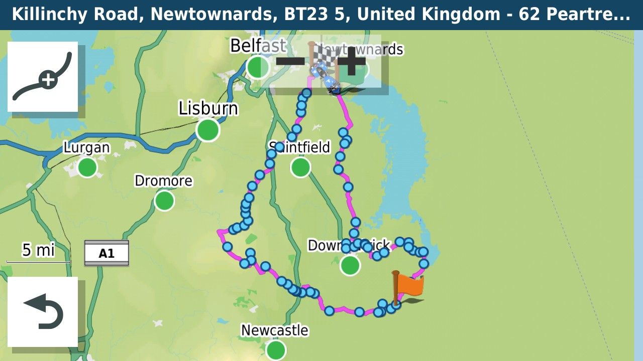
Garmin in their wisdom (or otherwise) have changed the routing behaviour with regard to shaping points somewhere between my Zumo 340/390 and the XT. On the old units the recalculation directed you to the next shaping point along the route. The XT routes to the closest shaping point, that on an out and back route might be on the way back. Therefore now with the XT you have to put a Via point at the farthest extent of an out and back route to ensure that the unit does not route back if a recalculation takes place.
Bottom line if you use GPX1.2 turn recalculations off on the XT. If you use GPX1.1 you can use recalculation as long as the route is carefully designed.
@Mzokk Nice write-up. I've only created two routes exported as 1.2 for import into my XT3, and they ran exactly as developed in MRA. It was nice not to have to overload shaping points to force calculations as I planned. On my last test, I did intentionally go off the route line once, but I didn't recalculate and the route picked back up when I reentered the road.
On that note, as strange as it might seem, I've never skipped waypoints or performed off route re-calculations in my Zumo units. I have recalculation turned off and simply return to the route after I deviate for gas, food, or some other miscellaneous reason. Again, it's intentional, so it's never far enough off-route where I can't handle getting back to where I should be without XT help. I guess we all approach route execution differently.
Still, it's nice to understand how 1.1 and 1.2 handle off route recalculation differently.
-
@Mzokk Nice write-up. I've only created two routes exported as 1.2 for import into my XT3, and they ran exactly as developed in MRA. It was nice not to have to overload shaping points to force calculations as I planned. On my last test, I did intentionally go off the route line once, but I didn't recalculate and the route picked back up when I reentered the road.
On that note, as strange as it might seem, I've never skipped waypoints or performed off route re-calculations in my Zumo units. I have recalculation turned off and simply return to the route after I deviate for gas, food, or some other miscellaneous reason. Again, it's intentional, so it's never far enough off-route where I can't handle getting back to where I should be without XT help. I guess we all approach route execution differently.
Still, it's nice to understand how 1.1 and 1.2 handle off route recalculation differently.
@John-S-Parry I agree John.
If you don't include via points between your starting and ending via points and then skip them while navigating a route, it seems that you can rejoin your planned route manually if you have auto recalculation turned off with the 1.2 format. That's fine and easy to manage for me
That makes sense as basically (with my simplistic thought process) as a 1.2 route with only a beginning and ending via point is basically a track that's been converted to a route.
When you introduce an intermediate via point in the route and then skip it, you give the Garmin the permission to totally ignore your planned route and do whatever it wants to do and recalculate the route as it sees fit!

For me personally if I just want a GPS to determine a route for me based on its on algorithms I'll just use Google Maps or Waze, but that's not why I use MRA! I want to determine exactly where I go when I'm riding!
Garmin, LEAVE MY ******** ROUTE ALONE!!! I don't need your help!!!
-
@John-S-Parry I agree John.
If you don't include via points between your starting and ending via points and then skip them while navigating a route, it seems that you can rejoin your planned route manually if you have auto recalculation turned off with the 1.2 format. That's fine and easy to manage for me
That makes sense as basically (with my simplistic thought process) as a 1.2 route with only a beginning and ending via point is basically a track that's been converted to a route.
When you introduce an intermediate via point in the route and then skip it, you give the Garmin the permission to totally ignore your planned route and do whatever it wants to do and recalculate the route as it sees fit!
For me personally if I just want a GPS to determine a route for me based on its on algorithms I'll just use Google Maps or Waze, but that's not why I use MRA! I want to determine exactly where I go when I'm riding!
Garmin, LEAVE MY ******** ROUTE ALONE!!! I don't need your help!!!
@Steve-Jarrell I am curious about one scenario under 1.2......
One of my favorite features in the Zumo is "Up Ahead". I've found it invaluable for locating gas stations and restaurants in areas I'm unfamiliar with. I was recently riding with a friend in the coastal Redwood forests along US-101 in far Northern California. Desolation doesn't describe how isolated that area is. We were heading south with no civilization is sight. And we were getting hungry.
 On the Zumo, I selected "Up Ahead", then the Restaurant category, and saw a small town a few miles west of the route that had a highly rated burger place. I selected it, and the Zumo gave me the option of adding the diversion to my route. Again, I selected it and the off/on diversion worked perfectly. I'm wondering if under the covers that was a full route recalculate, and if my 1.2 route would have been altered up further ahead in an undesirable way?
 -
@simon-james-hancock, also learned the hard way is if you start your route with 'CEP' (closest entry point) and either your end point or some other part of the route is closer to you than the start point, you can ride a very short route! In which case, choose the 'Start'.
If you wish to mark a petrol station or similar without creating a via point, create a POI of it in MRA. You can name it whatever you like and change the symbol. It will only show up as a flag and name on your Zumo though - these can be edited. There will be no distance or time shown to it but very handy nonetheless.
I'll reaffirm what I said earlier re 'auto-recalculate' with GPX1.2. It can be left on if you wish to be guided back to your route. It does not (in my tests) recalculate you to the next via point.
-
Carl that is exactly what happened to me when my end point was closer to me when I set off than my start point, thanks.
I will try the POI when creating the map in MRA.
Maybe when selecting a petrol station in the Up Ahead menue it will not be neccessary to creat a POI. -

I've found when creating routes especially circular ones with a start and finish point close together or an "out and back" route using some of the same roads that the best way is to plan my route and then split it into 2 routes using the MRA split function so I have an "OUTBOUND" route and a "RETURN" route. That way I can totally eliminate the issue of confusion when skipping or recalculating of the XT misrouting to a point that is on my return leg rather than my outbound leg.
-
Brilliant!
I have now created an out bound and inbound route.
Later on I will give it a try.
Thanks everyone for the patcience and time taken to answer my questions.
Pardon the pun but things are taking shape. -
Brilliant!
I have now created an out bound and inbound route.
Later on I will give it a try.
Thanks everyone for the patcience and time taken to answer my questions.
Pardon the pun but things are taking shape.
@Simon-James-Hancock It appears from reading through all of this that your XT and XT2 will behave slightly differently with GPX 1.2 files. The XT and older Garmin devices will recalculate according to their own parameters if you use GPX 1.2 and accidently recalculate the route. This behaviour will not be fixed by Garmin as the units are now discontinued. I've tested this in simulation mode and riding the bike with a GPX 1.2 route on the Garmin Zumo XT you cannot let the unit recalculate. This is fine as all that happens is that the unit goes quiet until you re join the magenta line. For the XT2/3 it appears that recent software updates from Garmin mean that if you deviate from a GPX1.2 route you can leave automatic recalculation on and the device will navigate back to the route.
-
@John-S-Parry I agree John.
If you don't include via points between your starting and ending via points and then skip them while navigating a route, it seems that you can rejoin your planned route manually if you have auto recalculation turned off with the 1.2 format. That's fine and easy to manage for me
That makes sense as basically (with my simplistic thought process) as a 1.2 route with only a beginning and ending via point is basically a track that's been converted to a route.
When you introduce an intermediate via point in the route and then skip it, you give the Garmin the permission to totally ignore your planned route and do whatever it wants to do and recalculate the route as it sees fit!
For me personally if I just want a GPS to determine a route for me based on its on algorithms I'll just use Google Maps or Waze, but that's not why I use MRA! I want to determine exactly where I go when I'm riding!
Garmin, LEAVE MY ******** ROUTE ALONE!!! I don't need your help!!!
When you introduce an intermediate via point in the route and then skip it, you give the Garmin the permission to totally ignore your planned route and do whatever it wants to do and recalculate the route as it sees fit!
Via points have always been a nuisance if you don't visit them no matter what GPX format is used. I use them a lot on trek events where we have to visit multiple points but other than that use them very sparingly. Next time I get a chance, I'll build a 1.2 route with some extra via points and ride it. They'll be in places where the XT2 would find it a lot quicker to re-route in order to get to the next via point if skipped. I'm not sure when this will be but standby......
-
@simon-james-hancock, also learned the hard way is if you start your route with 'CEP' (closest entry point) and either your end point or some other part of the route is closer to you than the start point, you can ride a very short route! In which case, choose the 'Start'.
If you wish to mark a petrol station or similar without creating a via point, create a POI of it in MRA. You can name it whatever you like and change the symbol. It will only show up as a flag and name on your Zumo though - these can be edited. There will be no distance or time shown to it but very handy nonetheless.
I'll reaffirm what I said earlier re 'auto-recalculate' with GPX1.2. It can be left on if you wish to be guided back to your route. It does not (in my tests) recalculate you to the next via point.
@Carl-Lee Very good to know. Thanks!!
-
When you introduce an intermediate via point in the route and then skip it, you give the Garmin the permission to totally ignore your planned route and do whatever it wants to do and recalculate the route as it sees fit!
Via points have always been a nuisance if you don't visit them no matter what GPX format is used. I use them a lot on trek events where we have to visit multiple points but other than that use them very sparingly. Next time I get a chance, I'll build a 1.2 route with some extra via points and ride it. They'll be in places where the XT2 would find it a lot quicker to re-route in order to get to the next via point if skipped. I'm not sure when this will be but standby......
@Carl-Lee As long as you don't mind the Garmin rerouting you to get from via point to via point it's not an issue, but if you're expecting to follow the route that you planned you may or may not do so!
-
@Steve-Jarrell I am curious about one scenario under 1.2......
One of my favorite features in the Zumo is "Up Ahead". I've found it invaluable for locating gas stations and restaurants in areas I'm unfamiliar with. I was recently riding with a friend in the coastal Redwood forests along US-101 in far Northern California. Desolation doesn't describe how isolated that area is. We were heading south with no civilization is sight. And we were getting hungry.
On the Zumo, I selected "Up Ahead", then the Restaurant category, and saw a small town a few miles west of the route that had a highly rated burger place. I selected it, and the Zumo gave me the option of adding the diversion to my route. Again, I selected it and the off/on diversion worked perfectly. I'm wondering if under the covers that was a full route recalculate, and if my 1.2 route would have been altered up further ahead in an undesirable way?
@John-S-Parry I'm not sure. That will be a good test. I will bet it does force a recalculate. However as has been pointed out here it very well may be device dependent (XT-XT2-XT3).
That's a beautiful part of the country. I flew into Seattle a few years ago and drove down the west coast mainly on the 101 to San Diego for a couple of weeks. The prettiest part of the drive was WA - OR - Northern CA by far.
Steve Jarrell
Western North Carolina USLifetime Routeplanner Gold & Navigation Next
2025 BMW R1300GS
2025 Can-Am Spyder
DMD T865-X 8" Tablet
Garmin XT3 -
@John-S-Parry I'm not sure. That will be a good test. I will bet it does force a recalculate. However as has been pointed out here it very well may be device dependent (XT-XT2-XT3).
That's a beautiful part of the country. I flew into Seattle a few years ago and drove down the west coast mainly on the 101 to San Diego for a couple of weeks. The prettiest part of the drive was WA - OR - Northern CA by far.
@Steve-Jarrell Yes, the WA - OR - Northern CA sections of the west coast have incredible scenery. I always try to catch that area when there are known periods of good weather and clear skies. But from a pure riding perspective, Central California has some of the best backroad riding to be found anywhere. That's my backyard, and I try to take full advantage of it.
Back to the "Up Ahead" and what adding diversions does to a route -- I'll construct a test to see how much of the overall route is touched. Like you, I hate any recalculation because I never trust what might actually be altered. My routes have a given shape for a reason and changing them on the fly during execution goes against my intent. Using a feature like "Up Ahead" is a valid alteration (to me) given a specific circumstance, so I'll investigate that further.
-
So long as you have your track visible, none of this is a major problem. And in any case, it's always quite easy to get back to your intended route by stopping it then restarting with CEP.
I spend some time planning the specific roads I want us to go down so also hate it being messed up. I'm really pleased with how 1.2 handles a normal deviation so finding out about skipped via points and "Up Ahead" deviations will be interesting.
-
@Steve-Jarrell Yes, the WA - OR - Northern CA sections of the west coast have incredible scenery. I always try to catch that area when there are known periods of good weather and clear skies. But from a pure riding perspective, Central California has some of the best backroad riding to be found anywhere. That's my backyard, and I try to take full advantage of it.
Back to the "Up Ahead" and what adding diversions does to a route -- I'll construct a test to see how much of the overall route is touched. Like you, I hate any recalculation because I never trust what might actually be altered. My routes have a given shape for a reason and changing them on the fly during execution goes against my intent. Using a feature like "Up Ahead" is a valid alteration (to me) given a specific circumstance, so I'll investigate that further.
@John-S-Parry Yes, I have been rerouted onto some.... well let's say "interesting" roads that I didn't plan on being on in the past!
Hello! It looks like you're interested in this conversation, but you don't have an account yet.
Getting fed up of having to scroll through the same posts each visit? When you register for an account, you'll always come back to exactly where you were before, and choose to be notified of new replies (either via email, or push notification). You'll also be able to save bookmarks and upvote posts to show your appreciation to other community members.
With your input, this post could be even better 💗
Register Login




-
 0788
0788
-
 07110
07110
-
 017144
-
04113
-
06222
-
0143.0k
-
16207