Suggestions
-
De enige manier (die ik op dit moment zie) waarop Next voor mijn gebruiksscenario's bruikbaar gaat zijn, is als de navigatie primair op basis van de in MRA Routeplanner (of andere software) uitgerekende route (gerepresenteerd in GPX als de track) plaats gaat vinden, zonder dat de app zelf gaat rekenen aan hoe de route moet gaan lopen.
Als er van die route afgeweken wordt, zou het standaardgedrag m.i. moeten zijn om via de snelste weg terug te worden gestuurd naar de route (dit is dus dynamisch o.b.v. hoe ver je van de route afwijkt). Aangezien de route niet is berekend o.b.v. routepunten in deze situatie, is het overslaan van routepunten hierbij niet relevant.
Routepunten (met name via-punten) zijn interessant voor stops e.d. dus zichtbaarheid/hoorbaarheid hiervan is belangrijk, ook als ze niet primair voor navigatie gebruikt worden. Hoe meer mogelijkheden er zijn om die zichtbaarheid/hoorbaarheid in te kunnen stellen (dus evt. ook uit te kunnen schakelen), hoe beter in mijn optiek.
M.b.t. het halverwege starten van een route: het zou mooi zijn als je bij het openen van de route c.q. het starten van de navigatie, gevraagd wordt of je naar het startpunt, of naar het dichtstbijzijnde punt wilt rijden. Naar het dichtstbijzijnde punt is uiteraard gelijk als van de route afwijken en kan dus op dezelfde manier afgehandeld worden (via de snelste weg naar de dichtstbijzijnde plek op de route).
Daarnaast zou het mooi zijn om op elk gewenst moment via de snelste weg naar een te kiezen routepunt te kunnen rijden, waarbij de geplande route dus wordt genegeerd.
English:
The only way I can currently see Next being suitable for my use cases, is when navigation is primarily based on the route as it has been calculated by MRA Routeplanner (or other software) (currently represented in GPX as the track), without the app recalculating what the route should be.When deviations from this route occur, the standard behaviour should be to direct the user back to the route by the fastest route (this should be dynamically calculated on the fly). As the route is not primarily based on waypoints, skipping them becomes irrelevant in this scenario.
Waypoints (in particular via points) are still very relevant even when they are not used as the primary means of navigation, as they denote stops or other important points on the route, so they should be visible/audible during navigation. The more options users have to fine-tune the visibility/audibility of waypoints (to the point of turning them off completely), the better, in my opinion.
With regards to starting halfway along the route, it would be nice if the app would ask the user whether they want to start at the beginning of route or at the nearest location on the route. This should then be handled in the same way as a deviation from the route, i.e. direct the user to the nearest location on the route in the fastest way.
It would also be very nice to be able to drive to any route point in the fastest way at any time the user desires, ignoring the planned route.
@Herko-ter-Horst Eigenlijk dus navigeren op basis van een track i.p.v. routepunten die je naar de app stuurt... toch? Pas dan weet je dat er geen extra berekeningen plaatsvinden. Gewoon de lijn volgen maar dan wel turn-by-turn.
-
If you want to know how Navigation or Next can be improved, I might suggest you look at the competition. Right now, when it comes to identifying actual worthy competition, I might suggest looking at Scenic. Do a head to head comparison identifying the strengths and weaknesses of each. When done, maybe areas where MRA Navigation/Next can be improved will be illuminated.
One area that MRA Navigation scores a point is that it's available on both iOS and Android. However, if the Scenic website holds true, that advantage won't be long lived. They are supposed to be delivering an Android version of Scenic soon.
-In- en uitschakelbare functie voor automatisch herberekenen van de route.
-Mogelijkheid om bij een obstakel in de route een alternatieve routedeel te berekenen. Liefst met een keuze ten aanzien van de lengte van het alteratief.-Switchable automatic route recalculation function.
-Possibility to calculate an alternative route section in the event of an obstacle in the route. Preferably with a choice regarding the length of the alternative. -
-In- en uitschakelbare functie voor automatisch herberekenen van de route.
-Mogelijkheid om bij een obstakel in de route een alternatieve routedeel te berekenen. Liefst met een keuze ten aanzien van de lengte van het alteratief.-Switchable automatic route recalculation function.
-Possibility to calculate an alternative route section in the event of an obstacle in the route. Preferably with a choice regarding the length of the alternative.@Jack-van-Tilburg said in Suggestions:
-In- en uitschakelbare functie voor automatisch herberekenen van de route.
Dit vind ik een sterk punt van mijn Garmin, zeker als ik per sé de ingestelde route wil volgen. Daar laat ik ook de track in een afwijkende kleur tonen tijdens het rijden. Als je van de route afwijkt, dan kan je op de kaart nog steeds de track zien (afhankelijk van het zoom-niveau).
-
@Rob-Verhoeff said in Suggestions:
@Jack-van-Tilburg said in Suggestions:
-In- en uitschakelbare functie voor automatisch herberekenen van de route.
Dit vind ik een sterk punt van mijn Garmin, zeker als ik per sé de ingestelde route wil volgen.
Feitelijk is het een lapmiddel om het volgen van een track in plaats van een route mogelijk te maken. Bij voldoende vertrouwen in een correcte route is het volledig overbodig. Aan de andere kant zou het wel publiek met een Garmin achtergrond kunnen overhalen
")
I am just an enthusiastic MRA user, and hope you will be one too!
Most motorcycle problems are caused by the nut that connects the handlebar to the saddle.
Check out RideSleepRepeat.eu, a biker community for sharing stays across Europe
-
@Rob-Verhoeff said in Suggestions:
@Jack-van-Tilburg said in Suggestions:
-In- en uitschakelbare functie voor automatisch herberekenen van de route.
Dit vind ik een sterk punt van mijn Garmin, zeker als ik per sé de ingestelde route wil volgen.
Feitelijk is het een lapmiddel om het volgen van een track in plaats van een route mogelijk te maken. Bij voldoende vertrouwen in een correcte route is het volledig overbodig. Aan de andere kant zou het wel publiek met een Garmin achtergrond kunnen overhalen
@Con-Hennekens
Nee. Je hebt ongelijk.
Als je niet herberekend blijft de route in beeld en heb je de track niet nodig.
En deze suggestie is niet voor niets gedaan samen met:
-Mogelijkheid om bij een obstakel in de route een alternatieve routedeel te berekenen. Liefst met een keuze ten aanzien van de lengte van het alteratief. -
@Con-Hennekens
Nee. Je hebt ongelijk.
Als je niet herberekend blijft de route in beeld en heb je de track niet nodig.
En deze suggestie is niet voor niets gedaan samen met:
-Mogelijkheid om bij een obstakel in de route een alternatieve routedeel te berekenen. Liefst met een keuze ten aanzien van de lengte van het alteratief.@ Allen ben ik wellicht te ambitieus als ik zou willen voorstellen om te vragen om zowel de mogelijkheid te hebben met track als met route kunnen te kunnen navigeren hehe. Als de app beide kan en beide manieren perfect gaan, dan zijn alle partijen tevreden!

Manks bu'j te bange.
-
@ Allen ben ik wellicht te ambitieus als ik zou willen voorstellen om te vragen om zowel de mogelijkheid te hebben met track als met route kunnen te kunnen navigeren hehe. Als de app beide kan en beide manieren perfect gaan, dan zijn alle partijen tevreden!
@StefanHummelink for president


-
Should also note that the are on V3 of Scenic. The tutorial video was for V2.
-
Here is something that I hope goes away in Next... The requirement to zoom in to see POIs (at least be able to disable it).
Posted this suggestion in the General Discussion forum...
-
@Michel-van-Hagen-MRA-Founder Niet zozeer random: maar ik zou in de eerste versie van februari toch al wel verwachten dat de nieuwe nav functie ook goed omgaat met "offroad" routepunten. De huidige app kan dat niet en dat is toch echt praktisch zeker wel een gemis. Hier komen op het forum zeer veel berichten van binnen.
@StefanHummelink Helemaal mee eens. Zeker het laden van een track die offroad navigatie mogelijk maakt zou dit een unieke app maken.
-
Continuing the theme of finding inspiration by looking at the competition... I've been glancing through Scenic's documentation and videos. Thought I might jot down some difference that may be worth noting. If I note something that differs between the two apps, but there isn't really a difference - I just missed the feature in MRA Navigation - let me know.
A couple of glaring differences... First, Scenic doesn't have it's own web based route/trip planner. However, it's not necessary really. Scenic's interoperability/integration with other planners (to include Furkot) makes it a minor point. Second, Scenic doesn't have any traffic capabilities. Advantage MRA Navigation.
Settings:
- Scenic has Show Compass on Map and Show Map Scale settings. Those might be handy. Points to Scenic.
- Map Styles. Scenic allows you to select various. I don't know about anybody else, but when you zoom out a little bit on the map in MRA Navigation, you can't see any roads. Even when you are zoomed in, the roads can still be hard to see depending on the lighting (re. out in the sun). Having different map styles to improve readability might be handy.
- Detour behavior. Scenic handles detours? Might be handy.
- Scenic's Via Point Pro Mode. Allows user control of shaping point visibility. I've mentioned this before. Point to Scenic.
That it's for the moment (the wife is after me). More to come later...
-
 Plaats random 'suggesties' in losse topics, zo kunnen we ze taggen en later nog eens bekijken. Ook houden we zo de discussies 'on topic' per suggestie! hou er rekening mee dat we tot 1 juni 2023 een strakke planning hebben. Maar daarna is er weer van alles mogelijk, dus hou je vooral niet in!
 Place random 'suggestions' in seperate topics, that way we can tag them and keep them marked for later use. That way, every suggestion has it's own 'on topic' discussion! keep in mind that we have a tight schedule until June 1, 2023. But after that, anything is possible again, so don't hold back!
EDIT 05/09 by Timo:
Locked topic and edited rules so that suggestions are posted in seperate topics.@Michel-van-Hagen-MRA-Founder would be great if you could include speed cameras in Europe.
-
 undefined Rob Verhoeff referenced this topic on
-
@Michel-van-Hagen-MRA-Founder would be great if you could include speed cameras in Europe.
@Bergefall said in Suggestions:
@Michel-van-Hagen-MRA-Founder would be great if you could include speed cameras in Europe.
Speed cameras are already included with the current MRA Navigation so I would presume that speed cameras would automatically feature in MRA Navigation Next
-
More looks at the competition etc...
Route list in MRA Navigation... either via Route planning or Navigation and tracking/Routes...
There is no sorting available. It only displays the last route open at the top. Scenic allows you to sort this via name, date, distance.
MRA Navigation Route list also doesn't appear to do folders.
Looking at the new MRA Mobile... It's route list is sortable, but only by name - which is too limited. It also does folders.
The main menu of MRA Mobile also brings up another point... What's the word I'm looking for here... Bifurcation? Anyway... You have a Route Lab button on the main menu that takes you to the web based route lab which offers the same menu options that are on the main menu of MRA Mobile. What's the point of this?
In fact, all things in the MRA Mobile menus seem to lead you back to the web based version (Edit for example). This is fine I guess if the everything you need on the web based version works/displays well on a mobile device (don't bother trying to look at a route in landscape). Another note... the progress bar doesn't seem to display in portrait mode.
I've already mentioned somewhere that when you are taken to the web based display of the routes via MRA Mobile that the spawned browser doesn't seem to have location access permissions and there doesn't seem to be a way to grant those permission. So, this makes the current usability of the MRA Mobile app more limited (beyond off road navigation - bike trails, hiking maybe - it seems to have no value). You are better off just opening your browser - which you can give location permissions to - and going directly to the MRA website to do things like route editing etc.
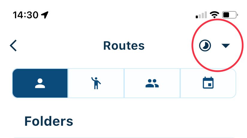
@Tim-Thompson said in Suggestions:
Looking at the new MRA Mobile... It's route list is sortable, but only by name - which is too limited. It also does folders.
Folders and routes can also be sorted by time.
Always willing to help if I can.
Triumph Tiger 1200 XRT called Tina.
MRA Navigation Next and SilverFox BJ8 -
@Tim-Thompson said in Suggestions:
Looking at the new MRA Mobile... It's route list is sortable, but only by name - which is too limited. It also does folders.
Folders and routes can also be sorted by time.
@Nick-Carthew said in Suggestions:
@Tim-Thompson said in Suggestions:
Looking at the new MRA Mobile... It's route list is sortable, but only by name - which is too limited. It also does folders.
Folders and routes can also be sorted by time.
Thanks for the tip. Didn't notice that you had to click on the AZ to get it to switch to the clock.
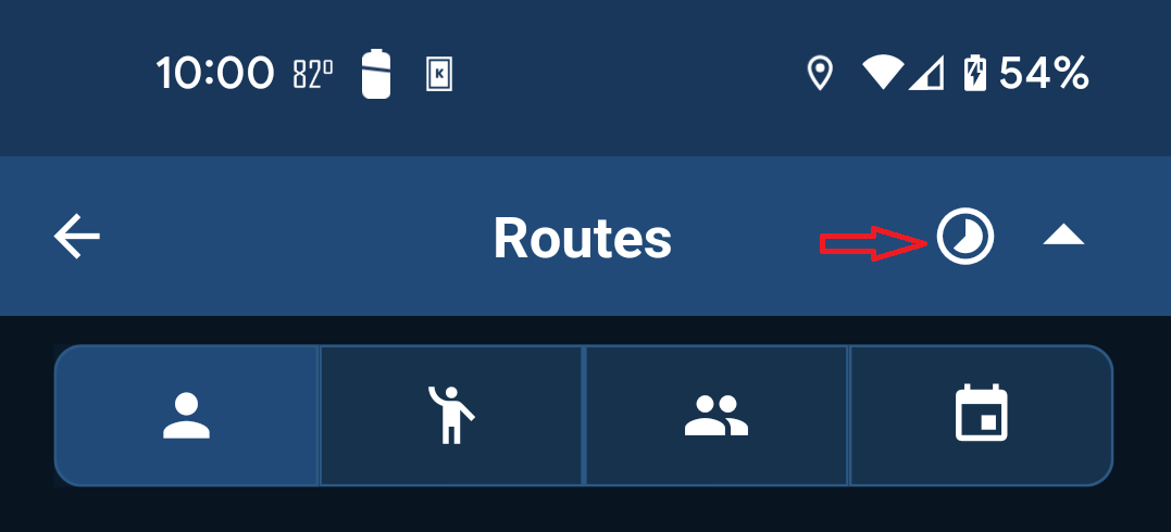
I was only clicking on the down/up arrow. For whatever reason clicking on the AZ wasn't obvious to me.
-
@Nick-Carthew said in Suggestions:
@Tim-Thompson said in Suggestions:
Looking at the new MRA Mobile... It's route list is sortable, but only by name - which is too limited. It also does folders.
Folders and routes can also be sorted by time.
Thanks for the tip. Didn't notice that you had to click on the AZ to get it to switch to the clock.
I was only clicking on the down/up arrow. For whatever reason clicking on the AZ wasn't obvious to me.
@Tim-Thompson I totally get why you missed that. The UX regarding this component does need some improvements
-
@Tim-Thompson I totally get why you missed that. The UX regarding this component does need some improvements
@Corjan-Meijerink said in Suggestions:
@Tim-Thompson I totally get why you missed that. The UX regarding this component does need some improvements
Hello! It looks like you're interested in this conversation, but you don't have an account yet.
Getting fed up of having to scroll through the same posts each visit? When you register for an account, you'll always come back to exactly where you were before, and choose to be notified of new replies (either via email, or push notification). You'll also be able to save bookmarks and upvote posts to show your appreciation to other community members.
With your input, this post could be even better 💗
Register Login-
4984
-
615113
-
06132
-
023489
-
0358
-
1957.5k
-
03128
-
018711