Ferry crossing
-
@Rob-Verhoeff
OK - I've set everything the recommended way, but it still doesn't work. Do you have any more tips?@Martin-Wilcke Normally, the route with the options I suggested should take the ferry. This option is also my preference because the map provider adds little to nothing with the motorbike profile. In this case, that doesn't work, and I don't understand why. Therefore, in your case, Nick's option is the recommended method.
🏍️ BMW K1600GT-P (2013) | Nolan N100-5 with Sena 30K
📱 iOS on iPhone 13 & 16 (mounted on Quadlock or AliExpress extention on BMW-cradle)
🚙 Apple CarPlay in VW T-Roc
💻 Routelab on MacBook Air & iMac (Tahoe & Ventura) -
@Martin-Wilcke Normally, the route with the options I suggested should take the ferry. This option is also my preference because the map provider adds little to nothing with the motorbike profile. In this case, that doesn't work, and I don't understand why. Therefore, in your case, Nick's option is the recommended method.
@Rob-Verhoeff said in Ferry crossing:
@Martin-Wilcke Normally, the route with the options I suggested should take the ferry. This option is also my preference because the map provider adds little to nothing with the motorbike profile. In this case, that doesn't work, and I don't understand why. Therefore, in your case, Nick's option is the recommended method.
Auch wenn es schwer zu verstehen ist, der Anteil an Motorradfahrer mit größerem „Gerät“ im Verkehr ist in D nur 10%. In südlichen Länder gibt es tw. mehr Zweiräder, aber dann vielfach Roller für den Stadt- und Nahverkehr und nicht als Reisefahrzeuge.
Die Prioritäten von Here sind halt nicht bei den Bikern und wie bekannt ist deren Entwicklungsschwerpunkt aktuell das Unterstützen des autonomen Fahrens.Ein jeder der hier sein Problem sieht, was nicht supportet wird,muss sich selbst fragen, womit verdiene ich eigentlich mein Geld und würde ich was tun, wo zu wenig zu verdienen ist.
In einem solchen Fall ist man bei OSM, aber nicht bei HERE. -
@Martin-Wilcke set route optimalisation to shortest
@Marinus-van-Deudekom said in Ferry crossing:
set route optimalisation to shortest
I did so. Please see post #1.
-
Thanks, @Nick-Carthew .
I used Garmins for about two decades and was happy. However, I never looked back after switching to "Smartphone navigation" two years ago. There are a lot of exciting apps out there, but MRA Navigation Next is by far the best all-in-one solution, and that's my choice.
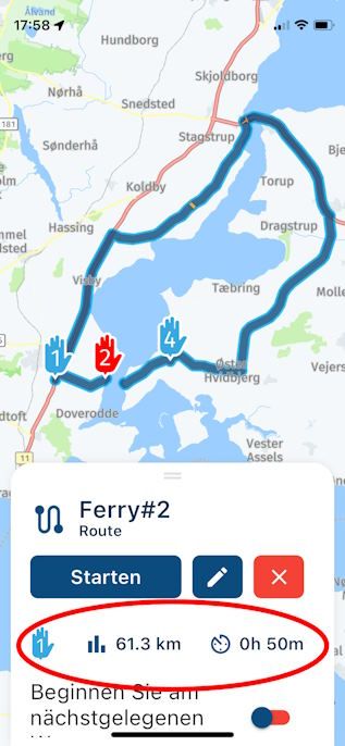
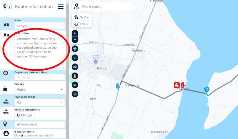
Your suggestions are the best option. The only downside is that the routes' calculated time and distance are too long. So, adding a note to the description might be worth it.
The second best option would be to break it up into two routes - hmmm.
The third option is to take it as a sign of fate and not use the ferry

-
@Martin-Wilcke Normally, the route with the options I suggested should take the ferry. This option is also my preference because the map provider adds little to nothing with the motorbike profile. In this case, that doesn't work, and I don't understand why. Therefore, in your case, Nick's option is the recommended method.
-
Thanks, @Nick-Carthew .
I used Garmins for about two decades and was happy. However, I never looked back after switching to "Smartphone navigation" two years ago. There are a lot of exciting apps out there, but MRA Navigation Next is by far the best all-in-one solution, and that's my choice.
Your suggestions are the best option. The only downside is that the routes' calculated time and distance are too long. So, adding a note to the description might be worth it.
The second best option would be to break it up into two routes - hmmm.
The third option is to take it as a sign of fate and not use the ferry
@Martin-Wilcke said in Ferry crossing:
The second best option would be to break it up into two routes - hmmm.
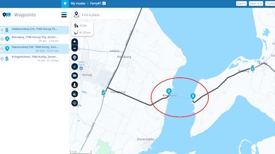
Simply ignore the directions and navigate to the ferry by placing a viapoint there (handsymbol). Once you're on the other side, you'll see that MRA will automatically pick up the route again. So, you just need to look past the suggested route until you reach the ferry. On the other side, all will be resolved

-
Thanks, @Nick-Carthew .
I used Garmins for about two decades and was happy. However, I never looked back after switching to "Smartphone navigation" two years ago. There are a lot of exciting apps out there, but MRA Navigation Next is by far the best all-in-one solution, and that's my choice.
Your suggestions are the best option. The only downside is that the routes' calculated time and distance are too long. So, adding a note to the description might be worth it.
The second best option would be to break it up into two routes - hmmm.
The third option is to take it as a sign of fate and not use the ferry
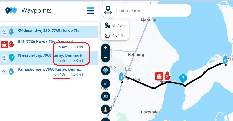
@Martin-Wilcke Using the skip function does not include time and distance, the time and distance is calculated as zero. Without using the skip function the time of the route is 1 hour instead of 10 minutes + ferry time.
Always willing to help if I can.
Triumph Tiger 1200 XRT called Tina.
MRA Navigation Next and SilverFox BJ8 -
@Martin-Wilcke Using the skip function does not include time and distance, the time and distance is calculated as zero. Without using the skip function the time of the route is 1 hour instead of 10 minutes + ferry time.
@Nick-Carthew said in Ferry crossing:
Using the skip function does not include time and distance, the time and distance is calculated as zero
That's true when planning. However, the effect may appear when opening the route in MRA NN:
A simple note might help avoid confusion. That's what I meant.
-
@Nick-Carthew said in Ferry crossing:
Using the skip function does not include time and distance, the time and distance is calculated as zero
That's true when planning. However, the effect may appear when opening the route in MRA NN:
A simple note might help avoid confusion. That's what I meant.
@Martin-Wilcke A good point well made

-
HERE should just skip all ferry time schedules for inland ferries, and add a 10 minute duration time or even set it to zero. For preventing navigation over ferries there already are features available.
Hello! It looks like you're interested in this conversation, but you don't have an account yet.
Getting fed up of having to scroll through the same posts each visit? When you register for an account, you'll always come back to exactly where you were before, and choose to be notified of new replies (either via email, or push notification). You'll also be able to save bookmarks and upvote posts to show your appreciation to other community members.
With your input, this post could be even better 💗
Register Login-
0988
-
0673
-
-320460
-
014239
-
0374
-
09177
-
0322
-
0210