Skip to content
  • Categories
  • Recent
  • Popular
  • Support
  • MyRoute-app
Collapse
Brand Logo

MRA Community Forum

  1. Home
  2. [Beta] The MyRoute-app
  3. [Beta] Suggestions and Discussions
  4. Suggestion: display road closures on map

Suggestion: display road closures on map

Scheduled Pinned Locked Moved [Beta] Suggestions and Discussions
12 Posts 6 Posters 191 Views 1 Watching
  • Oldest to Newest
  • Newest to Oldest
  • Most Votes
Reply
  • Reply as topic
Log in to reply
This topic has been deleted. Only users with topic management privileges can see it.
  • richtea999 Offline
    richtea999 Offline
    richtea999
    Valued contributor
    wrote on last edited by richtea999
    #1

    Whilst I was leading a route, the navigation started struggling with the route - sending me up dead-ends and back again. This happened 3 times in the space of a couple of kilometres - it was obvious that they weren't sensible routes, but not why. We parked up and compared TomTom with MRA.

    It turned out that there was a road closure on the original route. The difference was that TomTom displayed the road closure, and MRA stayed silent (no indicators of any problems on the map), and thus its attempts to re-route were very confusing!

    If road closures are known about in the MRA/HERE routing engine, is it possible to add them to the map, so the user can make visual sense of the enforced change of route?

    Con Hennekens 1 Reply Last reply
    3
    • richtea999 richtea999

      Whilst I was leading a route, the navigation started struggling with the route - sending me up dead-ends and back again. This happened 3 times in the space of a couple of kilometres - it was obvious that they weren't sensible routes, but not why. We parked up and compared TomTom with MRA.

      It turned out that there was a road closure on the original route. The difference was that TomTom displayed the road closure, and MRA stayed silent (no indicators of any problems on the map), and thus its attempts to re-route were very confusing!

      If road closures are known about in the MRA/HERE routing engine, is it possible to add them to the map, so the user can make visual sense of the enforced change of route?

      Con Hennekens Offline
      Con Hennekens Offline
      Con Hennekens
      Alpha tester
      wrote on last edited by
      #2

      @richtea999, when in settings the "show original route" toggle is enabled, you can see the deviation where the blue route line is going around a piece of the original route. But indeed, it would be great of the blocked part got a red route line for example.

      I am just an enthusiastic MRA user, and hope you will be one too!

      Most motorcycle problems are caused by the nut that connects the handlebar to the saddle.

      Check out RideSleepRepeat.eu, a biker community for sharing stays across Europe

      1 Reply Last reply
      0
      • lasironayahoo.com Offline
        lasironayahoo.com Offline
        lasironayahoo.com
        wrote on last edited by
        #3

        I think this would be a really useful feature in planning as well. Here's a good example from California...

        Here's a planned route from SF Bay Area to Santa Barbara in MRA:
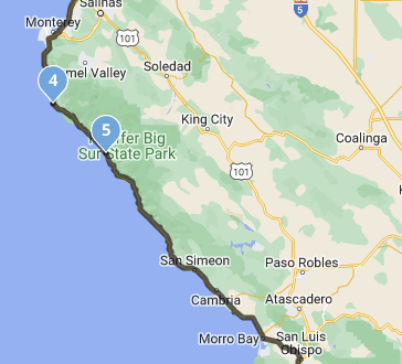
        d8b41247-d33f-47d2-b405-f1c0b317e591-image.png

        Then, if you look at the same section in Google Maps with traffic:
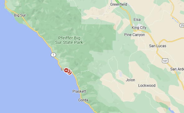
        4d7557ff-5e68-46c0-96bd-bb8be28bd804-image.png

        Those red dots are road closures until December 2023.

        iPhone 14 Pro

        1 Reply Last reply
        2
        • Jörgen Offline
          Jörgen Offline
          Jörgen
          Valued contributor
          wrote on last edited by
          #4

          You can switch on Traffic in the planning app (under maps) to see also road closure with black lines.
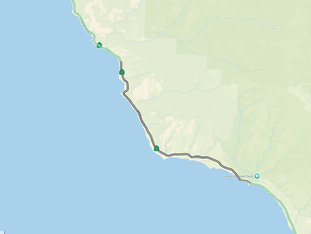
          32139854-f58a-40db-b2b3-b2ef5684c66a-image.png

          Hardware
          iPhone 12 pro (iOS 26.2.1)
          iPad (7.Gen.) 18.7.3
          Oukitel RT3 Pro (Andr. 14)
          Wireless CarPlay mit (Elebest C650)
          Wired CarPlay (SEAT Arona - 2021)
          MRA Workshops in Deutsch sind hier zu finden

          1 Reply Last reply
          0
          • Corjan Meijerink Offline
            Corjan Meijerink Offline
            Corjan Meijerink
            Developer
            wrote on last edited by
            #5

            If known closures, the app will display them.
            Routeplanner might not as planning isn’t as time based.

            richtea999 1 Reply Last reply
            0
            • lasironayahoo.com Offline
              lasironayahoo.com Offline
              lasironayahoo.com
              wrote on last edited by
              #6

              Ok, I see what you mean. I would have to walk the path prior to setting my next waypoint. Otherwise, the planned route is black and the road closure indicator is black. Although not optimum, it works. Is there a way to change the color of the planned route? I know there's a transparency setting, but I don't remember seeing colors

              iPhone 14 Pro

              1 Reply Last reply
              0
              • lasironayahoo.com Offline
                lasironayahoo.com Offline
                lasironayahoo.com
                wrote on last edited by
                #7

                You can disregard... After spending some time with the traffic setting, I noticed that every other status isn't black. I can use that as an indicator.

                I typically just let routelab set the route unless there's something about the area I want to see. That's why I was curious, so I wouldn't have to walk the routes ahead of time not knowing which route the routelab was actually going to use.

                iPhone 14 Pro

                1 Reply Last reply
                0
                • Corjan Meijerink Corjan Meijerink

                  If known closures, the app will display them.
                  Routeplanner might not as planning isn’t as time based.

                  richtea999 Offline
                  richtea999 Offline
                  richtea999
                  Valued contributor
                  wrote on last edited by
                  #8

                  @Corjan-Meijerink said in Suggestion: display road closures on map:

                  If known closures, the app will display them.
                  Routeplanner might not as planning isn’t as time based.

                  Thanks Corjan, is there an example screenshot so I know what the closures will look like next time? (I didnt see anything, but I have, on other occasions, seen a lighter route line, which I guess is the 'original route' mentioned by Jörgen.)

                  Corjan Meijerink 1 Reply Last reply
                  0
                  • richtea999 richtea999

                    @Corjan-Meijerink said in Suggestion: display road closures on map:

                    If known closures, the app will display them.
                    Routeplanner might not as planning isn’t as time based.

                    Thanks Corjan, is there an example screenshot so I know what the closures will look like next time? (I didnt see anything, but I have, on other occasions, seen a lighter route line, which I guess is the 'original route' mentioned by Jörgen.)

                    Corjan Meijerink Offline
                    Corjan Meijerink Offline
                    Corjan Meijerink
                    Developer
                    wrote on last edited by
                    #9

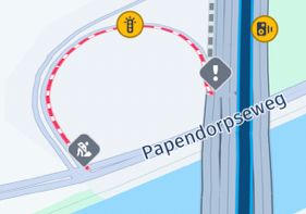
                    @richtea999 it’s a dashed red line.
                    Cannot find one either at this point and I’ll definitely forget replying later - sorry 🙂

                    1 Reply Last reply
                    0
                    • richtea999 richtea999 referenced this topic on
                    • Corjan Meijerink Offline
                      Corjan Meijerink Offline
                      Corjan Meijerink
                      Developer
                      wrote on last edited by
                      #10

                      Like this 🙂

                      DB7212C0-DB18-435A-B53B-2ED595789EE6.jpeg

                      Which is different from the red delay line:
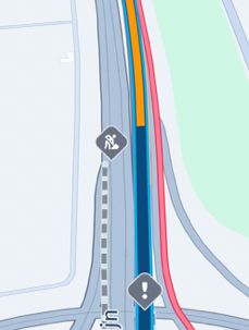
                      127DC72D-B75F-41AF-B23B-0B3ADF479AA9.jpeg

                      Arno 0 1 Reply Last reply
                      1
                      • Corjan Meijerink Corjan Meijerink

                        Like this 🙂

                        DB7212C0-DB18-435A-B53B-2ED595789EE6.jpeg

                        Which is different from the red delay line:

                        127DC72D-B75F-41AF-B23B-0B3ADF479AA9.jpeg

                        Arno 0 Offline
                        Arno 0 Offline
                        Arno 0
                        wrote on last edited by
                        #11

                        @Corjan-Meijerink the examples given are pictures from the navigation app and these make very clear that the road is blocked. However, when creating a route in the planner it's not so clear because then a small black line is shown which you only see when you zoom in. Maybe something to improve when updating the planner 🙂

                        1 Reply Last reply
                        2
                        • Arno 0 Offline
                          Arno 0 Offline
                          Arno 0
                          wrote on last edited by Arno 0
                          #12

                          Another thing I forgot to mention is that when you select "disable seasonal closures" in the toolkit in the planner, you will not only not see the mountain passes that are closed during winter period but will also not see any road blocks. Therefore it might be good to change the name of the toolkit function in future.

                          1 Reply Last reply
                          0

                          Hello! It looks like you're interested in this conversation, but you don't have an account yet.

                          Getting fed up of having to scroll through the same posts each visit? When you register for an account, you'll always come back to exactly where you were before, and choose to be notified of new replies (either via email, or push notification). You'll also be able to save bookmarks and upvote posts to show your appreciation to other community members.

                          With your input, this post could be even better 💗

                          Register Login
                          Reply
                          • Reply as topic
                          Log in to reply
                          • Oldest to Newest
                          • Newest to Oldest
                          • Most Votes


                          ACTIVE USERS
                          Corjan Meijerink
                          Corjan Meijerink
                          Con Hennekens
                          Con Hennekens
                          Jörgen
                          Jörgen
                          richtea999
                          richtea999
                          Arno 0
                          Arno 0
                          lasironayahoo.com
                          lasironayahoo.com
                          POPULAR TOPICS
                          • Paar onduidelijkheden.
                            Travellexxie
                            Travellexxie
                            1
                            16
                            165

                          • Giving folders its own color
                            Brian McG
                            Brian McG
                            0
                            9
                            201

                          • Er gaat hier iets mis melding
                            Travellexxie
                            Travellexxie
                            0
                            14
                            293

                          • Wegwerkzaamheden worden niet goed toegepast
                            Con Hennekens
                            Con Hennekens
                            0
                            7
                            115

                          • Route app reageert niet
                            Erik Schouten
                            Erik Schouten
                            0
                            4
                            46

                          • Vormingspunt, viapunt en Eindpunt op Carplay
                            Huibertus
                            Huibertus
                            0
                            3
                            30

                          • Blauwe routelijn lijft in Carplay wit
                            Corjan Meijerink
                            Corjan Meijerink
                            0
                            4
                            66

                          • New update 5.2 - Avoid roadblocks, persistent map items, POI management and share
                            M. Schrijver
                            M. Schrijver
                            28
                            61
                            7.0k

                          MY GROUPS
                          • Login

                          • Login or register to search.
                          • First post
                            Last post
                          0
                          • Categories
                          • Recent
                          • Popular
                          • Support
                          • MyRoute-app