The Route Called for an Incorrect Turn
-
I created a route in the web MRA Route Planner and synced the route in MRA Next. I rode the route offline since I'd be going into areas without cell service. I ran into a situation where I was directed to make a left turn that wasn't part of the route. Here is the section of the route in question:
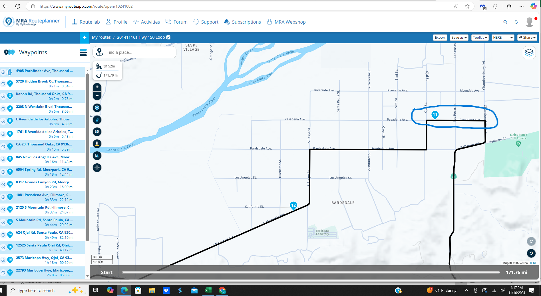
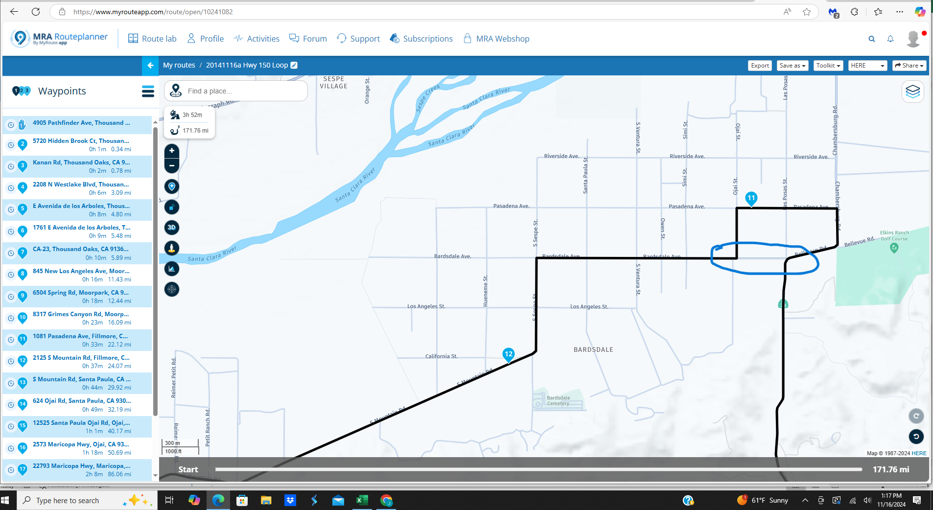
I should have been directed to turn left on Pasadena Ave (waypoint#11) as shown on the above screen print. Instead, I was directed to turn left on Bardsdale Ave, the previous street, in the screen shot below:
At that point, directed turns became non-sensical, so I terminated the route. I've tried to figure it out myself, but I'm stumped.
Here is the route set to public. Any help would be appreciated:
-
I created a route in the web MRA Route Planner and synced the route in MRA Next. I rode the route offline since I'd be going into areas without cell service. I ran into a situation where I was directed to make a left turn that wasn't part of the route. Here is the section of the route in question:
I should have been directed to turn left on Pasadena Ave (waypoint#11) as shown on the above screen print. Instead, I was directed to turn left on Bardsdale Ave, the previous street, in the screen shot below:
At that point, directed turns became non-sensical, so I terminated the route. I've tried to figure it out myself, but I'm stumped.
Here is the route set to public. Any help would be appreciated:
@John-S-Parry Out of interest, do you have Skip waypoints automatically selected?
Always willing to help if I can.
Triumph Tiger 1200 XRT called Tina.
MRA Navigation Next and SilverFox BJ8 -
@John-S-Parry Out of interest, do you have Skip waypoints automatically selected?
@Nick-Carthew No, it's set to OFF. I don't like skipping waypoints unless it's a very unique situation.
I was thinking of going back and running the route online to see if there was any difference, but no time today.
-
@John-S-Parry I won't have time to ride the route for a while. I did create a 1.1 GPX from MRA desktop and imported it into Garmin Basecamp. It looks good. The turn-by-turn instructions are correct, and the route plays as expected. I also imported the GPX into my Garmin XT, and the map looks as it should. The turn-by-turn instructions also shows the route executing as expected.
Just some more information for what its worth.
@John-S-Parry One other thought.......
I was running the route offline, and it's been a few months since I downloaded the US/California Map. Has anything changed with the latest App updates that would require reloading maps? If there's guideline that maps should be reloaded after major updates, I'm all ears. I'm trying to look at different angles.....
-
@John-S-Parry One other thought.......
I was running the route offline, and it's been a few months since I downloaded the US/California Map. Has anything changed with the latest App updates that would require reloading maps? If there's guideline that maps should be reloaded after major updates, I'm all ears. I'm trying to look at different angles.....
@John-S-Parry One more question for now (I promise
 )
)This one might be best for @Corjan-Meijerink, but whoever can answer. When a route is created in the MRA Routeplanner (website) and then synced in the app for offline execution, does the route get recalculated with a different algorithm? Meaning, is it possible that the offline calculated route could be different than what shows on the website?
That's what happens in Garmin world. What you create in Garmin Basecamp might look slightly different in the Garmin Zumo XT because the routing algorithms are not identical.
-
@John-S-Parry One more question for now (I promise
)This one might be best for @Corjan-Meijerink, but whoever can answer. When a route is created in the MRA Routeplanner (website) and then synced in the app for offline execution, does the route get recalculated with a different algorithm? Meaning, is it possible that the offline calculated route could be different than what shows on the website?
That's what happens in Garmin world. What you create in Garmin Basecamp might look slightly different in the Garmin Zumo XT because the routing algorithms are not identical.
@John-S-Parry Differences between online and offline calculation are definitely possible. That would however relate more to long distances between waypoints. Your situation would not apply to that to be honest.
Bit unsure what the explanation could be when you've turned off the auto-skip setting. -
I created a route in the web MRA Route Planner and synced the route in MRA Next. I rode the route offline since I'd be going into areas without cell service. I ran into a situation where I was directed to make a left turn that wasn't part of the route. Here is the section of the route in question:
I should have been directed to turn left on Pasadena Ave (waypoint#11) as shown on the above screen print. Instead, I was directed to turn left on Bardsdale Ave, the previous street, in the screen shot below:
At that point, directed turns became non-sensical, so I terminated the route. I've tried to figure it out myself, but I'm stumped.
Here is the route set to public. Any help would be appreciated:
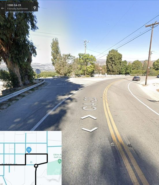
@John-S-Parry This is probably a map or interpretation problem. On Google street view you can see that turning left is not allowed at this point. Double solid lines show this.
Kindly regards
ReinhardMontana 700i and Mac
-
@John-S-Parry This is probably a map or interpretation problem. On Google street view you can see that turning left is not allowed at this point. Double solid lines show this.
@Reinhard-32 Yes, I live in the area and know it well. This is why I set waypoint #11 to turn left on the next street (Pasadena Ave), and loop back down. It's a HERE map thing (Basecamp does it too) to want to turn left at this dangerous Bardsdale Ave intersection in the absence of setting up shaping points to get around it as seen below:
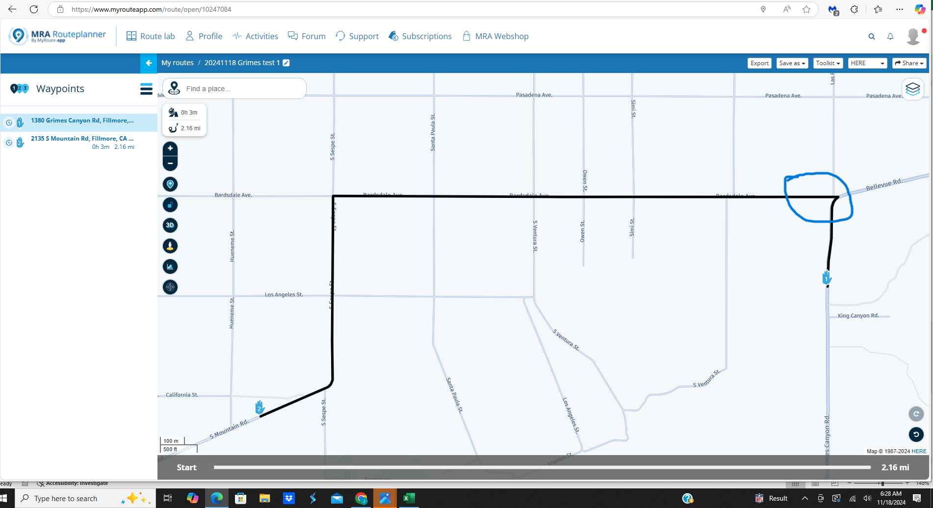
All mapping programs are capable of doing strange default routing, so that's why I like to overload with shaping points to leave nothing to chance. I'm more concerned about why MRA choose to ignore waypoint#11 and direct me to turn left where it shouldn't. I understand MRA by default wants to turn left at Bardsdale Ave, but waypoint #11 should override this.
I deleted and reloaded the US/California map to make sure there wasn't a map corruption issue. I also loaded the GPX route into my Garmin XT. I'm going to ride the route today with the Phone and the XT navigating at the same time. We'll see.
-
@Reinhard-32 Yes, I live in the area and know it well. This is why I set waypoint #11 to turn left on the next street (Pasadena Ave), and loop back down. It's a HERE map thing (Basecamp does it too) to want to turn left at this dangerous Bardsdale Ave intersection in the absence of setting up shaping points to get around it as seen below:
All mapping programs are capable of doing strange default routing, so that's why I like to overload with shaping points to leave nothing to chance. I'm more concerned about why MRA choose to ignore waypoint#11 and direct me to turn left where it shouldn't. I understand MRA by default wants to turn left at Bardsdale Ave, but waypoint #11 should override this.
I deleted and reloaded the US/California map to make sure there wasn't a map corruption issue. I also loaded the GPX route into my Garmin XT. I'm going to ride the route today with the Phone and the XT navigating at the same time. We'll see.
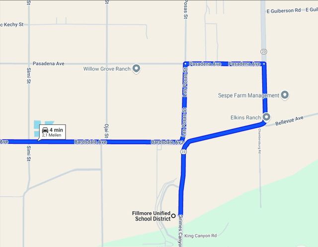
@John-S-Parry In contrast to MRA with HERE, TomTom or OSM maps, Google maps does it right and that without waypoint #11.
-
@Reinhard-32 Yes, I live in the area and know it well. This is why I set waypoint #11 to turn left on the next street (Pasadena Ave), and loop back down. It's a HERE map thing (Basecamp does it too) to want to turn left at this dangerous Bardsdale Ave intersection in the absence of setting up shaping points to get around it as seen below:
All mapping programs are capable of doing strange default routing, so that's why I like to overload with shaping points to leave nothing to chance. I'm more concerned about why MRA choose to ignore waypoint#11 and direct me to turn left where it shouldn't. I understand MRA by default wants to turn left at Bardsdale Ave, but waypoint #11 should override this.
I deleted and reloaded the US/California map to make sure there wasn't a map corruption issue. I also loaded the GPX route into my Garmin XT. I'm going to ride the route today with the Phone and the XT navigating at the same time. We'll see.
@John-S-Parry As referenced, I just rode the route again running the route on the Phone app and my Garmin XT in parallel.
The phone and the XT were completely in sync though waypoint #10. As I got close to the waypoint #11 trouble area up ahead, things changed. The MRA app again wanted me to turn left at the wrong street (Bardsdale Ave) while the XT was correctly directing me to turn left on Pasadena Ave to waypoint #11.
So out of curiosity, I pulled over and stopped the route on the app. I went to Navigation Settings and turned Offline Navigation OFF. I then restarted the route, and like the XT, it correctly directed me to turn left on Pasadena Ave to waypoint #11.
So, it appears there is a bug in Offline Navigation. I think I eliminated all other variables unless someone points out otherwise. @Corjan-Meijerink any additional thoughts?
-
@John-S-Parry As referenced, I just rode the route again running the route on the Phone app and my Garmin XT in parallel.
The phone and the XT were completely in sync though waypoint #10. As I got close to the waypoint #11 trouble area up ahead, things changed. The MRA app again wanted me to turn left at the wrong street (Bardsdale Ave) while the XT was correctly directing me to turn left on Pasadena Ave to waypoint #11.
So out of curiosity, I pulled over and stopped the route on the app. I went to Navigation Settings and turned Offline Navigation OFF. I then restarted the route, and like the XT, it correctly directed me to turn left on Pasadena Ave to waypoint #11.
So, it appears there is a bug in Offline Navigation. I think I eliminated all other variables unless someone points out otherwise. @Corjan-Meijerink any additional thoughts?
@John-S-Parry sounds solid!
Not much we can do about it then")
If it already works online, it might be available in an offline version too soon.
-
@John-S-Parry sounds solid!
Not much we can do about it thenIf it already works online, it might be available in an offline version too soon.
@Corjan-Meijerink Thanks. I think you're saying it's a recognized problem and it will (might?) be corrected in an update soon. I ride in remote mountainous areas without cell quite often, and reliable offline navigation is a must.
-
@Corjan-Meijerink Thanks. I think you're saying it's a recognized problem and it will (might?) be corrected in an update soon. I ride in remote mountainous areas without cell quite often, and reliable offline navigation is a must.
Hi @John-S-Parry what happens if you move point #11 to the east nearer to the left turn you really want to take?
I only ask because just looking at the distance from the first (dangerous) left turn to point #11, it looks like this may be the shortest / fastest route.
Where the difference in the routing algorithms / calculations might be is in how they take account of performing a U-turn.Whenever there are 2 possible paths to a point, I find you have to explicitly force any sat nav device to the path you desire by adding additional points or placing the points more precisely to the path you wish.
Here I think you may have placed point #11 just on the cusp of which path is the most efficient route, so you have left the device to do the thinking & got an ambiguous result, I could be wrong though
BlackView BV7100, Android 12
Navigate "Routes as Tracks" in Offline mode with Offline Maps
No Wifi, no internet, no interruptions, works well -
Hi @John-S-Parry what happens if you move point #11 to the east nearer to the left turn you really want to take?
I only ask because just looking at the distance from the first (dangerous) left turn to point #11, it looks like this may be the shortest / fastest route.
Where the difference in the routing algorithms / calculations might be is in how they take account of performing a U-turn.Whenever there are 2 possible paths to a point, I find you have to explicitly force any sat nav device to the path you desire by adding additional points or placing the points more precisely to the path you wish.
Here I think you may have placed point #11 just on the cusp of which path is the most efficient route, so you have left the device to do the thinking & got an ambiguous result, I could be wrong though@Brian-McG Good analysis. I originally thought about placing waypoint #11 further east near the left turn. However, that would have had the potential for causing a different problem. In MRA, if the waypoint is placed too close to the left turn, you don't get an audio turn instruction. It's hard to know exactly where that point is, so it's a guessing game. But to your point, I normally place these kind of shaping points closer. The Garmin XT isn't as fussy with exact placement.
My primary concern is that the route calculated correctly on the MRA website. It calculated correctly when I exported the GPX 1.1 file into Garmin Basecamp for outside interrogation. It calculated (and executed) correctly when I copied the GPX into my Garmin XT. And the when I synced the MRA website route with the MRA Next app, the route shows on the app exactly as I intend it. I don't get any warning of a problem until actually executing the route, which is the absolute wrong time for an uh-ho moment.
My expectation is that after route sync to the app, if an offline recalculation occurs, I'd see the difference right way. That's the way it works in Garmin world. Sometimes, what I create in Garmin Basecamp doesn't recalculate the same when the route is copied to the Garmin XT. The respective environments have slight different route calculation algorithms, so sometimes differences do happen. Then it's just a matter of going back to Basecamp (or MRA website if that's the source) and adjusting/adding necessary shaping points, recopying the route, reverifying, and I'm done.
After experiencing the MRA problem and getting home, I did modify the route on the website adding a few more shaping points and also moving waypoint #11 closer to the intersection. I'd like to go back to test (again), but it's 20-miles of backroads from my house, so it's a time consuming round trip exercise. I probably will still do it, but my first order of business is understanding what initially happened. If I can't trust the offline routing for all situations, I can't use it at all. I don't want to sound alarmist, but something like this could turn into a bad situation, especially if you're leading others in an unfamiliar area.
-
Hi @John-S-Parry what happens if you move point #11 to the east nearer to the left turn you really want to take?
I only ask because just looking at the distance from the first (dangerous) left turn to point #11, it looks like this may be the shortest / fastest route.
Where the difference in the routing algorithms / calculations might be is in how they take account of performing a U-turn.Whenever there are 2 possible paths to a point, I find you have to explicitly force any sat nav device to the path you desire by adding additional points or placing the points more precisely to the path you wish.
Here I think you may have placed point #11 just on the cusp of which path is the most efficient route, so you have left the device to do the thinking & got an ambiguous result, I could be wrong though@Brian-McG I carved out some time today and ran the route again. This time with a version where I added a 2 more shaping points as circled:
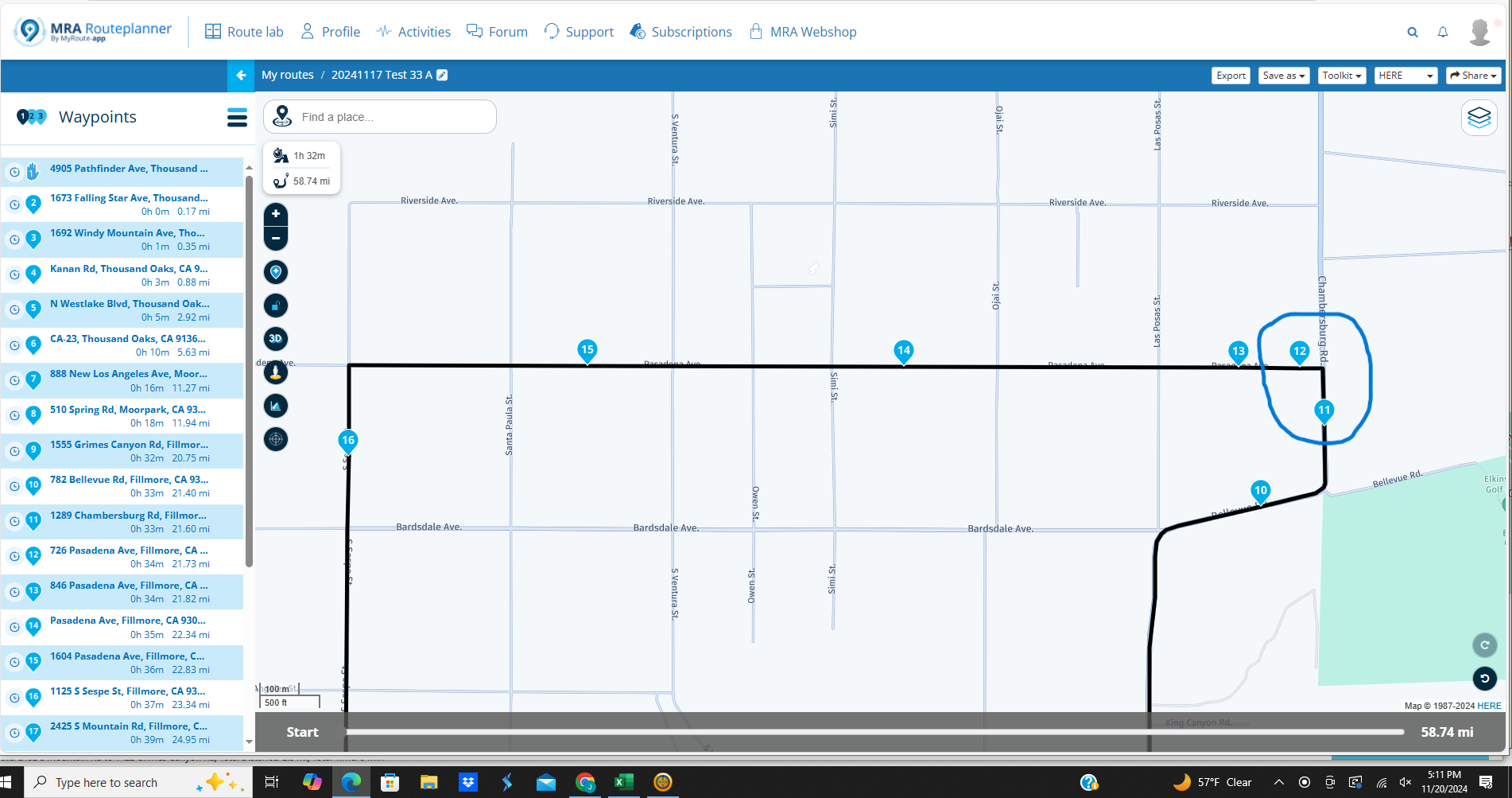
That did the trick, and Offline mode for the route worked. Waypoint #12 is too close after the turn, so I didn't get an audio announcement, but I was more concerned with simply forcing the turn on the correct street.
In the nutshell, Offline is functional, but the assumption I had regarding an MRA route calculating the same both online and offline (all the time) is incorrect. The lesson for me is to load up (or just plain overload) on shaping points to leave nothing to chance. I still think there should be some kind of alert when the calculations are different, but I feel comfortable continuing with offline navigation when needed. Thanks again for your input.
Hello! It looks like you're interested in this conversation, but you don't have an account yet.
Getting fed up of having to scroll through the same posts each visit? When you register for an account, you'll always come back to exactly where you were before, and choose to be notified of new replies (either via email, or push notification). You'll also be able to save bookmarks and upvote posts to show your appreciation to other community members.
With your input, this post could be even better 💗
Register Login-
011119
-
-436942
-
010167
-
1313228
-
0101.3k
-
0346
-
08716
-
03102