help with Garmin Zumo XT
-
@Mzokk Great information, can you post the link for the Garmin forum that you use? I got the XT because my other garmin kept changing my custom route if I took a wrong turn or stopped for gas. Very frustrating. I'm excited about making custom routes in MRA. I just have to get it all figured out on the best method to import it to my XT. Right now I just plug in my xt and drop the file into the gpx folder. Garmin explore doesn't seem to work with the xp. It says that the xt in not a supported device. I have some confusion on what file type to download is as. 1.1 gpx route, track, poi????? And when I open it on the XT if I need to open it in the trip planner or track or what. Can you help with that explaining the method you use? Thanks very much for taking the time to reply and thanks in advance for any help you can give me.
@Mike-wiruth the method I use to transfer routes and navigate using the XT are as follows.
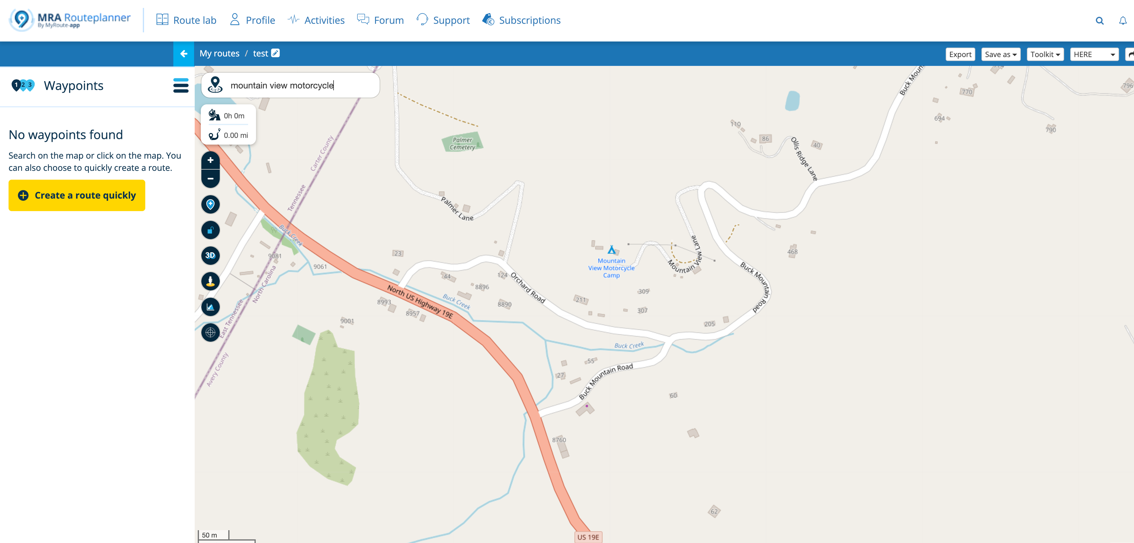
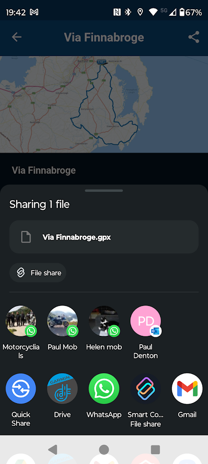
I usually plot my routes on the computer screen (unless I'm on tour) as its easier to work with a 27" screen that a phone. I transfer my routes from the phone to the XT via the App.
This is not an ideal route but will illustrate some issues that can arise with the XT
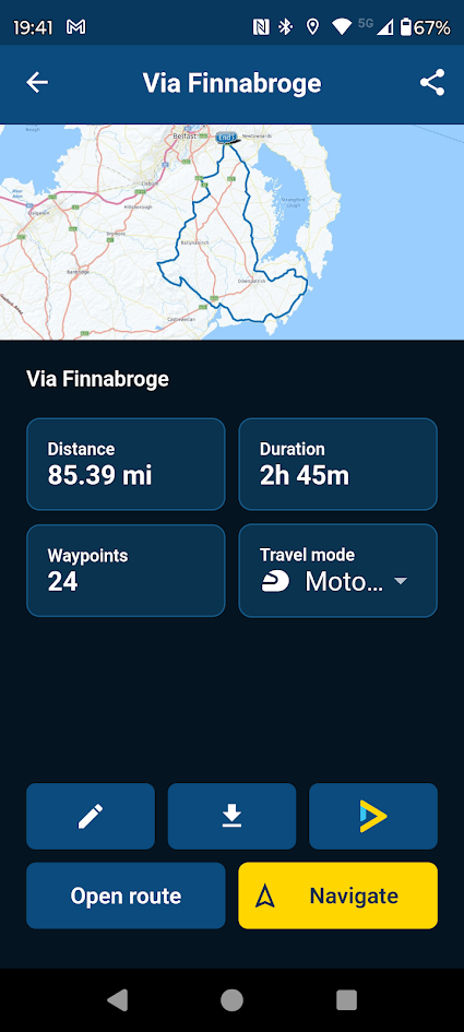
I download using GPX1.1 because this shows how you shaped the route using MRA and allows you to fix a route that does not go where you want on the XT. I also download the track of the route which will be as planned in MRA.
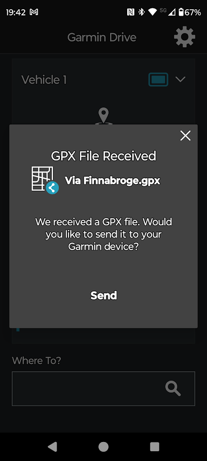
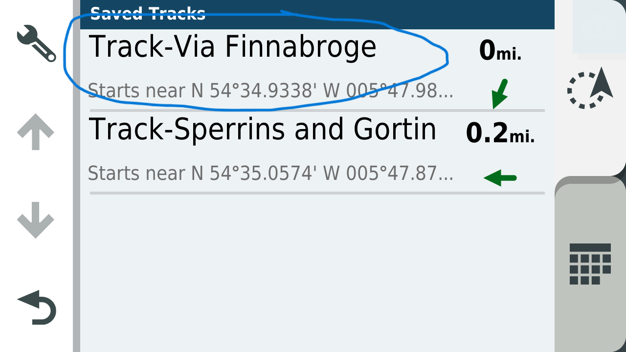
Route Received
![c7acc4d1-fc0d-43dc-ab25-19170a267ed7-17707[1].png](/assets/uploads/files/1724509876255-c7acc4d1-fc0d-43dc-ab25-19170a267ed7-17707-1.png)
Track Received
![e4f6a43b-a21c-4d68-826f-a95d84e17ce2-17294[2].png](/assets/uploads/files/1724509970280-e4f6a43b-a21c-4d68-826f-a95d84e17ce2-17294-2.png)
![3fc9385f-e0f3-468a-b15c-2c9dadf17506-20128[1].png](/assets/uploads/files/1724510168363-3fc9385f-e0f3-468a-b15c-2c9dadf17506-20128-1.png)
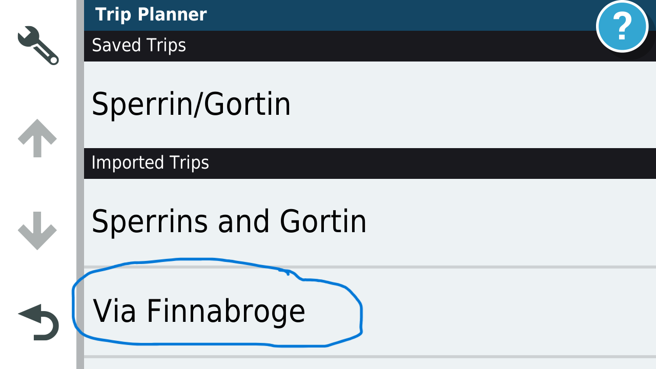
Open Trip planner route will be in list.
Track is in list.
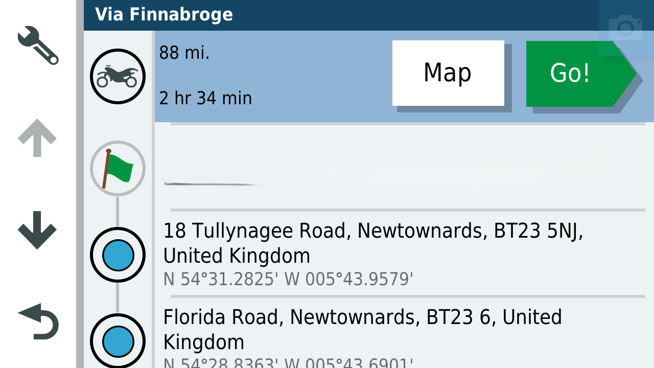
Open Route (Address near my house removed)
Open Track Default is blue but I change the colour to yellow.
![ba1b8f79-1756-4191-a27d-aca5296c87b1-31106[1].png](/assets/uploads/files/1724510507396-ba1b8f79-1756-4191-a27d-aca5296c87b1-31106-1.png)
Open the route and Track and make the track visible on the XT
![401edf8a-d088-40ed-b251-c9b2aa2188cc-36293[1].png](/assets/uploads/files/1724510639932-401edf8a-d088-40ed-b251-c9b2aa2188cc-36293-1.png)
You can see that I wanted to go along the coast but the XT's routing logic is taking me back to a town and then back to the intended route as designed. This can be fixed by putting in an extra shaping point in the XT.
![1f227e02-3dfa-4225-80c1-d45a27ea51ea-40542[1].png](/assets/uploads/files/1724510785674-1f227e02-3dfa-4225-80c1-d45a27ea51ea-40542-1.png)
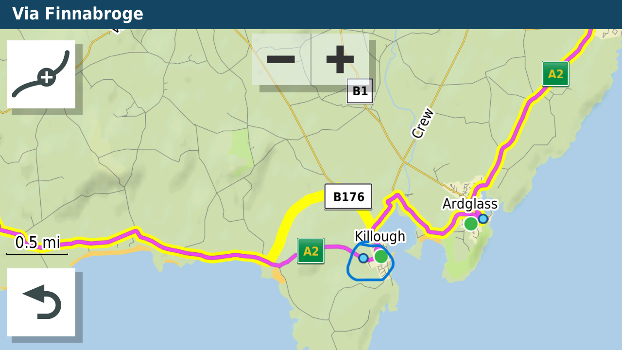
Or by ensuring there are enough waypoints in the route you designed in MRA.
I created a bespoke map theme for my XT that makes the Track line thicker and this can be seen below the route line even when navigating. It gives a heads up if the XT is going away from your intended route. I keep recalculate on the unit as "Prompted" and only use recalculate if I can't navigate back to my intended route using the screen. -
@Mike-wiruth the method I use to transfer routes and navigate using the XT are as follows.
I usually plot my routes on the computer screen (unless I'm on tour) as its easier to work with a 27" screen that a phone. I transfer my routes from the phone to the XT via the App.
This is not an ideal route but will illustrate some issues that can arise with the XT
I download using GPX1.1 because this shows how you shaped the route using MRA and allows you to fix a route that does not go where you want on the XT. I also download the track of the route which will be as planned in MRA.
Route Received
Track Received
Open Trip planner route will be in list.
Track is in list.
Open Route (Address near my house removed)
Open Track Default is blue but I change the colour to yellow.
Open the route and Track and make the track visible on the XT
You can see that I wanted to go along the coast but the XT's routing logic is taking me back to a town and then back to the intended route as designed. This can be fixed by putting in an extra shaping point in the XT.
Or by ensuring there are enough waypoints in the route you designed in MRA.
I created a bespoke map theme for my XT that makes the Track line thicker and this can be seen below the route line even when navigating. It gives a heads up if the XT is going away from your intended route. I keep recalculate on the unit as "Prompted" and only use recalculate if I can't navigate back to my intended route using the screen.@Mzokk said in help with Garmin Zumo XT:
Track is in list.
please correct me if i am wrong, as i have not had an XT for some time now
but off memory, you would not be able to see the track in the tracks menu if explore was running, hence why i posted the link to thread explaining how to remove explore.but I am only guessing from memeory as I do not have an XT, so maybe my input is pointless
to achieve, we must first attempt ✌️
K1600 GTL
Oukitel RT3
iPhone 13 Pro, carpuride 702b -
hi,
the above wording does not make my query clearIf explore is running and you send track and routes as either 1.2 or 1.1 to the XT using drive app, am i correct in thinking the tracks cannot be seen in the tracks menu.
yes that makes more sense
-
@Mike-wiruth the method I use to transfer routes and navigate using the XT are as follows.
I usually plot my routes on the computer screen (unless I'm on tour) as its easier to work with a 27" screen that a phone. I transfer my routes from the phone to the XT via the App.
This is not an ideal route but will illustrate some issues that can arise with the XT
I download using GPX1.1 because this shows how you shaped the route using MRA and allows you to fix a route that does not go where you want on the XT. I also download the track of the route which will be as planned in MRA.
Route Received
Track Received
Open Trip planner route will be in list.
Track is in list.
Open Route (Address near my house removed)
Open Track Default is blue but I change the colour to yellow.
Open the route and Track and make the track visible on the XT
You can see that I wanted to go along the coast but the XT's routing logic is taking me back to a town and then back to the intended route as designed. This can be fixed by putting in an extra shaping point in the XT.
Or by ensuring there are enough waypoints in the route you designed in MRA.
I created a bespoke map theme for my XT that makes the Track line thicker and this can be seen below the route line even when navigating. It gives a heads up if the XT is going away from your intended route. I keep recalculate on the unit as "Prompted" and only use recalculate if I can't navigate back to my intended route using the screen.@Mzokk I do so in the same manner and it works fine.
-
@Mike-wiruth the method I use to transfer routes and navigate using the XT are as follows.
I usually plot my routes on the computer screen (unless I'm on tour) as its easier to work with a 27" screen that a phone. I transfer my routes from the phone to the XT via the App.
This is not an ideal route but will illustrate some issues that can arise with the XT
I download using GPX1.1 because this shows how you shaped the route using MRA and allows you to fix a route that does not go where you want on the XT. I also download the track of the route which will be as planned in MRA.
Route Received
Track Received
Open Trip planner route will be in list.
Track is in list.
Open Route (Address near my house removed)
Open Track Default is blue but I change the colour to yellow.
Open the route and Track and make the track visible on the XT
You can see that I wanted to go along the coast but the XT's routing logic is taking me back to a town and then back to the intended route as designed. This can be fixed by putting in an extra shaping point in the XT.
Or by ensuring there are enough waypoints in the route you designed in MRA.
I created a bespoke map theme for my XT that makes the Track line thicker and this can be seen below the route line even when navigating. It gives a heads up if the XT is going away from your intended route. I keep recalculate on the unit as "Prompted" and only use recalculate if I can't navigate back to my intended route using the screen.@Mzokk said in help with Garmin Zumo XT:
I created a bespoke map theme for my XT that makes the Track line thicker and this can be seen below the route line
i did this too, it was brilliant way to see if the route had gone off somewhere else, instantly noticeable
-
@Mzokk said in help with Garmin Zumo XT:
Track is in list.
please correct me if i am wrong, as i have not had an XT for some time now
but off memory, you would not be able to see the track in the tracks menu if explore was running, hence why i posted the link to thread explaining how to remove explore.but I am only guessing from memeory as I do not have an XT, so maybe my input is pointless
@paul69 I don't use explore so the XT reverts to the old Garmin method of displaying a track by ticking it in the menu. The Drive app works fine without explore being installed on your phone or linked to your XT unit.
![04524e83-328d-485e-89f2-0d7231c0ff0c-7452[1].png](/assets/uploads/files/1724530710144-04524e83-328d-485e-89f2-0d7231c0ff0c-7452-1.png)
You obviously have to manually untick the track when you have finished using it.
-
@Mzokk said in help with Garmin Zumo XT:
Track is in list.
please correct me if i am wrong, as i have not had an XT for some time now
but off memory, you would not be able to see the track in the tracks menu if explore was running, hence why i posted the link to thread explaining how to remove explore.but I am only guessing from memeory as I do not have an XT, so maybe my input is pointless
@paul69 I am thinking of going down the route of using MRA for navigation as well as route planning. Sometimes the testing gets a bit ridiculous.
-
@paul69 I am thinking of going down the route of using MRA for navigation as well as route planning. Sometimes the testing gets a bit ridiculous.
-
@paul69 I don't use explore so the XT reverts to the old Garmin method of displaying a track by ticking it in the menu. The Drive app works fine without explore being installed on your phone or linked to your XT unit.
You obviously have to manually untick the track when you have finished using it.
@Mzokk
this is what i have been trying to explain to people, you do not get this option with explore activated.replied to this a bit late, but never mind
for those looking in, this refers to 3 posts above this one
-
hi @Mike-wiruth
just found this which was written by the font of knowledge on the zumo forum explaining how to get rid of explore.
https://www.zumouserforums.co.uk/app.php/ZXT-P56
this is also has an effect on viewing the routes/tracks in the XT menus, but thankfully i do not have to put up with the nuances of the XT any longer thanks to MRA
@paul69 Paul, thanks very much. I went to the link and followed the instructions and got rid of explore on my xt. I also signed up for the zumo forum. This should be a great place to get more zumo related answers. Thanks again for your help.
-
@Mike-wiruth the method I use to transfer routes and navigate using the XT are as follows.
I usually plot my routes on the computer screen (unless I'm on tour) as its easier to work with a 27" screen that a phone. I transfer my routes from the phone to the XT via the App.
This is not an ideal route but will illustrate some issues that can arise with the XT
I download using GPX1.1 because this shows how you shaped the route using MRA and allows you to fix a route that does not go where you want on the XT. I also download the track of the route which will be as planned in MRA.
Route Received
Track Received
Open Trip planner route will be in list.
Track is in list.
Open Route (Address near my house removed)
Open Track Default is blue but I change the colour to yellow.
Open the route and Track and make the track visible on the XT
You can see that I wanted to go along the coast but the XT's routing logic is taking me back to a town and then back to the intended route as designed. This can be fixed by putting in an extra shaping point in the XT.
Or by ensuring there are enough waypoints in the route you designed in MRA.
I created a bespoke map theme for my XT that makes the Track line thicker and this can be seen below the route line even when navigating. It gives a heads up if the XT is going away from your intended route. I keep recalculate on the unit as "Prompted" and only use recalculate if I can't navigate back to my intended route using the screen.@Mzokk So how do you display both the track and the route? I checked my xt and went to trip planner and opened up the trip I designed. Then what do you do? Go back and open the track too? When I downloaded it I chose gpx 1.2 route, track, poi
-
@Mike-wiruth the method I use to transfer routes and navigate using the XT are as follows.
I usually plot my routes on the computer screen (unless I'm on tour) as its easier to work with a 27" screen that a phone. I transfer my routes from the phone to the XT via the App.
This is not an ideal route but will illustrate some issues that can arise with the XT
I download using GPX1.1 because this shows how you shaped the route using MRA and allows you to fix a route that does not go where you want on the XT. I also download the track of the route which will be as planned in MRA.
Route Received
Track Received
Open Trip planner route will be in list.
Track is in list.
Open Route (Address near my house removed)
Open Track Default is blue but I change the colour to yellow.
Open the route and Track and make the track visible on the XT
You can see that I wanted to go along the coast but the XT's routing logic is taking me back to a town and then back to the intended route as designed. This can be fixed by putting in an extra shaping point in the XT.
Or by ensuring there are enough waypoints in the route you designed in MRA.
I created a bespoke map theme for my XT that makes the Track line thicker and this can be seen below the route line even when navigating. It gives a heads up if the XT is going away from your intended route. I keep recalculate on the unit as "Prompted" and only use recalculate if I can't navigate back to my intended route using the screen.@Mzokk Also where in settings do you change the color of routes and tracks? Also, how did you get those great screen shots of your xt screen? Thanks for all your hard work of posting this reply. Great work. I was a great help. You might regret it though, I'm a learner, always wanting to learn more and I might burden you with questions. LOL
Mike W
2013 Honda Goldwing
Bushtec Trailer
Garmin Zumo XT
Nebraska
youTube channel https://www.youtube.com/@mrjawmaster5854 -
@Mzokk Also where in settings do you change the color of routes and tracks? Also, how did you get those great screen shots of your xt screen? Thanks for all your hard work of posting this reply. Great work. I was a great help. You might regret it though, I'm a learner, always wanting to learn more and I might burden you with questions. LOL
@Mike-wiruth of you got rid of explore in your XT in the settings you can choose to display any track and choose the with and color.
They are display under your route so is you go of route it's instantly visibleHonda Goldwing GL1500,
Honda Silverwing GL 650
DMD2 T865X 8 inch Android tablet using MRA next for navigation
Garmin XT sold
Samsung S24FE mounted on a Quadlock and using Android Auto in my car -
@Mike-wiruth of you got rid of explore in your XT in the settings you can choose to display any track and choose the with and color.
They are display under your route so is you go of route it's instantly visible@Marinus-van-Deudekom How do you do it? I can't seem to open them both up at the same time. Also, need to know where to go to change the color of the track. Thanks for any help you can give me.
Mike W
2013 Honda Goldwing
Bushtec Trailer
Garmin Zumo XT
Nebraska
youTube channel https://www.youtube.com/@mrjawmaster5854 -
@Marinus-van-Deudekom How do you do it? I can't seem to open them both up at the same time. Also, need to know where to go to change the color of the track. Thanks for any help you can give me.
@Mike-wiruth Hi Mike if you go into tracks this is the sequence.
![19366[1].png](/assets/uploads/files/1724593449518-19366-1.png)
Open Tracks
![20875[1].png](/assets/uploads/files/1724593535281-20875-1.png)
Click on the spanner to show the track on the map. This stays on until you unclick it even if you are not navigating.
![24913[1].png](/assets/uploads/files/1724593726417-24913-1.png)
To change colour and width of the track you click on the spanner and scroll to the menu Item![21880[1].png](/assets/uploads/files/1724593848656-21880-1.png)
![22384[2].png](/assets/uploads/files/1724594138125-22384-2.png)
![23694[1].png](/assets/uploads/files/1724594271522-23694-1.png)
So you can set up the track of the route you intend to run at any time and the track will stay until you untick it.
-
@Mike-wiruth Hi Mike if you go into tracks this is the sequence.
Open Tracks
Click on the spanner to show the track on the map. This stays on until you unclick it even if you are not navigating.
To change colour and width of the track you click on the spanner and scroll to the menu ItemSo you can set up the track of the route you intend to run at any time and the track will stay until you untick it.
@Mzokk Great, thanks for those steps. When you set the properties of the track, to see both at once, do you have to Start the track, then back out and start the route? I looked at the route, and when I first looked at it I could see what looked like the track on the outside of the route, I made the track the widest and color in red. But, when I zoomed in, I couldn't see the track anymore. But, I guess the good news is the track was the same as the route. No deviation.

Hello! It looks like you're interested in this conversation, but you don't have an account yet.
Getting fed up of having to scroll through the same posts each visit? When you register for an account, you'll always come back to exactly where you were before, and choose to be notified of new replies (either via email, or push notification). You'll also be able to save bookmarks and upvote posts to show your appreciation to other community members.
With your input, this post could be even better 💗
Register Login-
1574
-
0452
-
08171
-
07155
-
08184
-
0425
-
0341.6k
-
7221.4k