Avoid blocked road
-
I have found several questions about blocked roads and the issue seems to be underlaying map information, e.g. that a blocked road is not yet registered as such.
However im my case, OpenStreetMap shows an interruption and a piece of the road is even missing. However all 3 algorithms (OpenStreetMap, Here, TomTom) use this road.

MyRoute-app planerOther planers (e.g. Kurviger) avoid this road.
KurvigerDo I have wrong settings, is it a lack in MyRoute-app planer or does it "work as designed" and the avoidance is not possible with MyRoute-app planer?
Thanks.
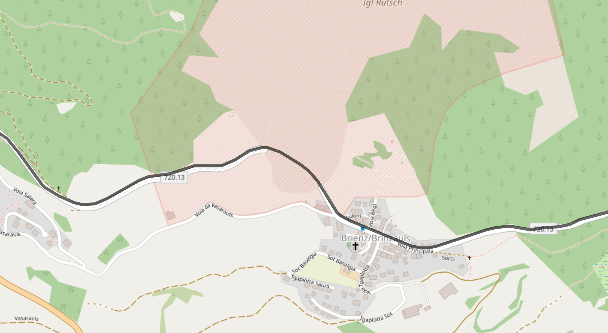
@Urs-4, Strangely enough even the Google Streetview car seems to have stopped there:
But the area is desginated "Igl Rutsch". I looked it up and see this picture on Google:
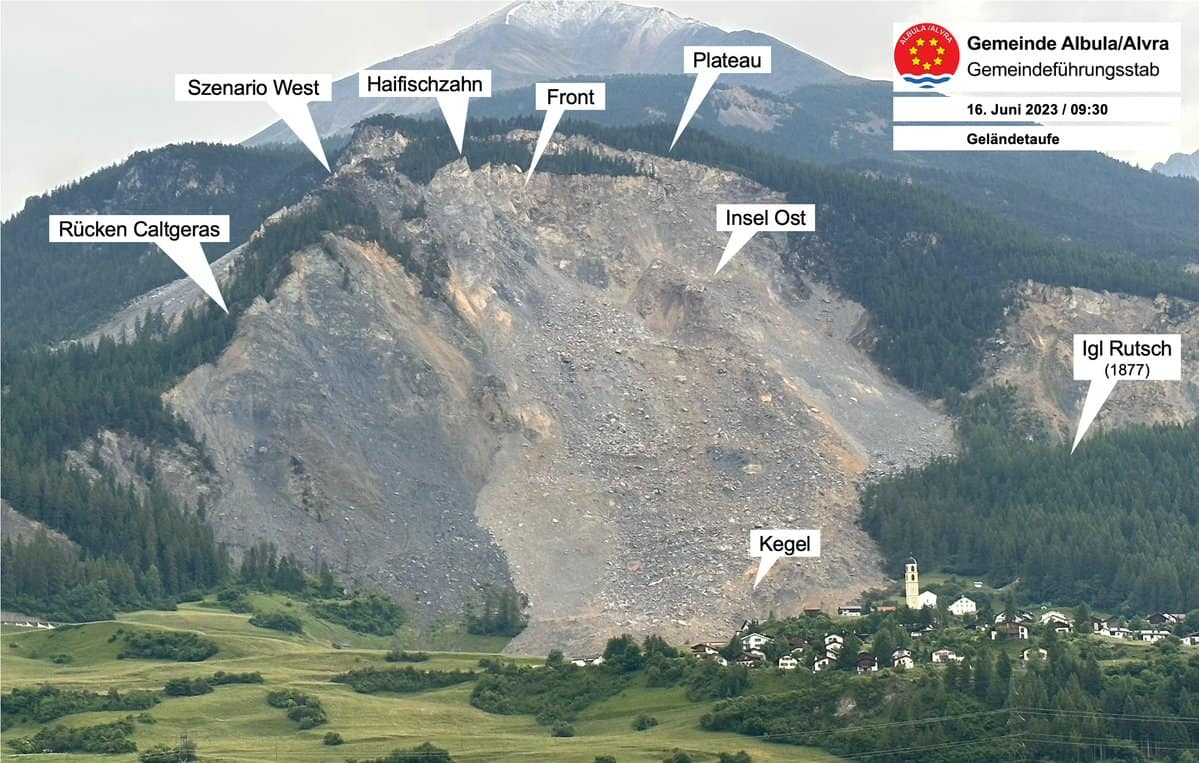
On this page: https://lenews.ch/2023/06/23/brienz-rock-slide-residents-allowed-into-village-from-monday/
So, the road is closed or restricted due to (danger of) landslide, but apparently some map-makers are not aware.
I am just an enthusiastic MRA user, and hope you will be one too!
Most motorcycle problems are caused by the nut that connects the handlebar to the saddle.
Check out RideSleepRepeat.eu, a biker community for sharing stays across Europe
-
@Urs-4, Strangely enough even the Google Streetview car seems to have stopped there:
But the area is desginated "Igl Rutsch". I looked it up and see this picture on Google:
On this page: https://lenews.ch/2023/06/23/brienz-rock-slide-residents-allowed-into-village-from-monday/
So, the road is closed or restricted due to (danger of) landslide, but apparently some map-makers are not aware.
@Con-Hennekens Thanks for your research. I think the landslide really destroyed the road about a year ago. I am actually not really concerned about this specific case.
There will be other situations where the deviation will be more important.So it is rather a generic question.
How can I avoid these roads/situations with MyRoute-app? If others can do it, the information must be there. -
@Con-Hennekens Thanks for your research. I think the landslide really destroyed the road about a year ago. I am actually not really concerned about this specific case.
There will be other situations where the deviation will be more important.So it is rather a generic question.
How can I avoid these roads/situations with MyRoute-app? If others can do it, the information must be there.@Urs-4, I don't think the road is completely destroyed. The Streetview pictures date back to august 2014, but 2024 satellite imagery shows a clear road and a shade suggests a wall has been built there. My guess that the road is restricted to local traffic. Some mapmakers consider that closed, others consider that open.
Interesting WIKI:
I see that all locations on the google map show: temporary closed. I think it is slowly becoming a ghost-village...
@Urs-4 said in Avoid blocked road:
How can I avoid these roads/situations with MyRoute-app? If others can do it, the information must be there.
The ham-question, with a simple answer: you can't...
")
The information is fragmented, there is no central registration.I am just an enthusiastic MRA user, and hope you will be one too!
Most motorcycle problems are caused by the nut that connects the handlebar to the saddle.
Check out RideSleepRepeat.eu, a biker community for sharing stays across Europe
-
@Urs-4, I don't think the road is completely destroyed. The Streetview pictures date back to august 2014, but 2024 satellite imagery shows a clear road and a shade suggests a wall has been built there. My guess that the road is restricted to local traffic. Some mapmakers consider that closed, others consider that open.
Interesting WIKI:
I see that all locations on the google map show: temporary closed. I think it is slowly becoming a ghost-village...
@Urs-4 said in Avoid blocked road:
How can I avoid these roads/situations with MyRoute-app? If others can do it, the information must be there.
The ham-question, with a simple answer: you can't...
The information is fragmented, there is no central registration.@Con-Hennekens
To get some impressions, here is a video about the landslide:
https://youtu.be/xhaneB34h48?si=p0dqE_Sm4xgR2wMUYou can find more on YouTube
-
@Urs-4, I don't think the road is completely destroyed. The Streetview pictures date back to august 2014, but 2024 satellite imagery shows a clear road and a shade suggests a wall has been built there. My guess that the road is restricted to local traffic. Some mapmakers consider that closed, others consider that open.
Interesting WIKI:
I see that all locations on the google map show: temporary closed. I think it is slowly becoming a ghost-village...
@Urs-4 said in Avoid blocked road:
How can I avoid these roads/situations with MyRoute-app? If others can do it, the information must be there.
The ham-question, with a simple answer: you can't...
The information is fragmented, there is no central registration.@Con-Hennekens Thanks again. I start to understand better.
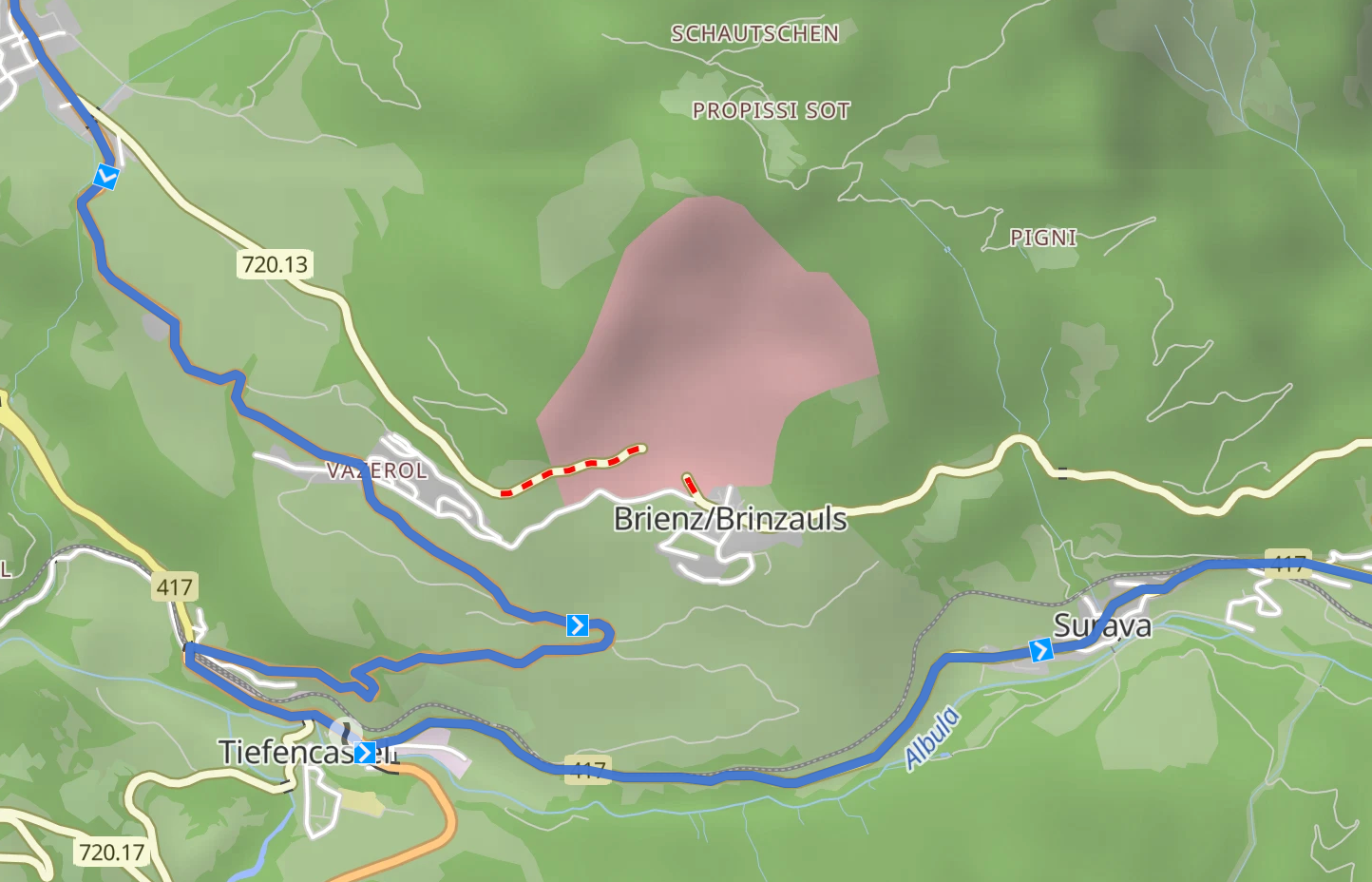
"Here" and "TomTom" maps show a continued road and therefore don't have the information.
I understand that they route over this road.
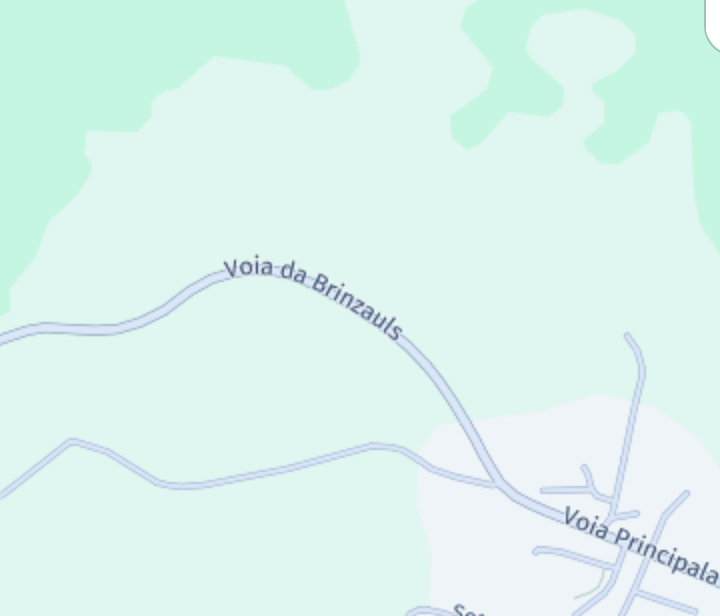
"Here" map
However, "OpenStreetMap" shows an interruption.
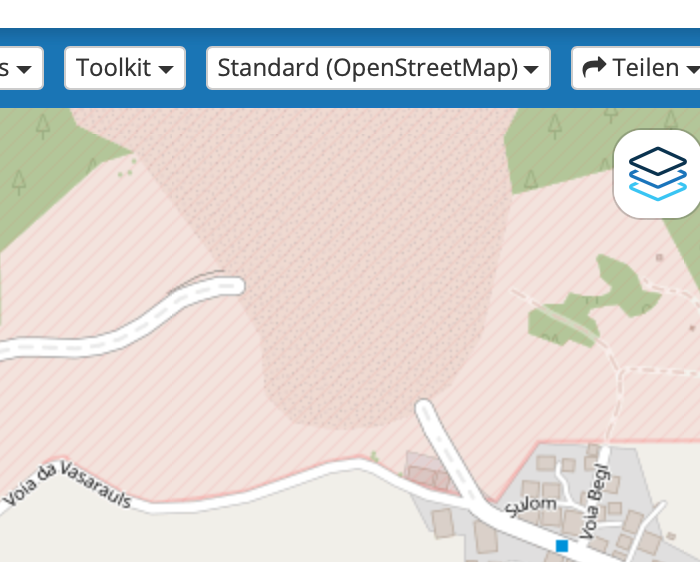
"OpenStreetMap"I guess the question boils down to why the OpenStreetMap algorithm uses this road.
The answer must be that MyRoute-app ignores this information with OpenStreetMap.Should I add this as an enhancement request?
-
@Con-Hennekens Thanks again. I start to understand better.
"Here" and "TomTom" maps show a continued road and therefore don't have the information.
I understand that they route over this road.
"Here" map
However, "OpenStreetMap" shows an interruption.
"OpenStreetMap"I guess the question boils down to why the OpenStreetMap algorithm uses this road.
The answer must be that MyRoute-app ignores this information with OpenStreetMap.Should I add this as an enhancement request?
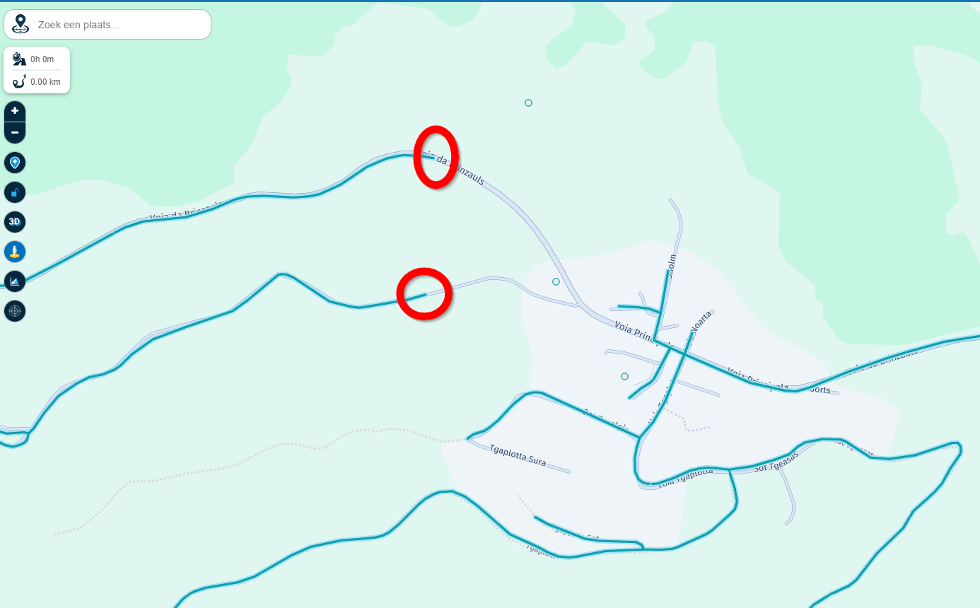
@Urs-4, I looked it up:
https://www.openstreetmap.org/edit#map=16/46.6708/9.6004
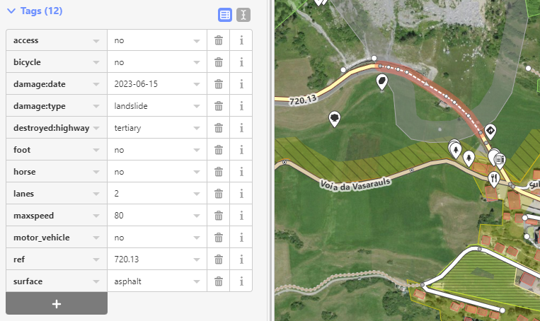
That piece of road seems to be explicitly reported as prohibited for all traffic.
If I switch to bicycle or foot, you are actually lead around it, it's just car-mode that does not lead around it. So I think you are on to something, and the traffic-awareness in OSM Car-mode is ignored. @Corjan-Meijerink, this might be something you want to check.It would be good if someone in that neighborhood could show road signs that show this closure. Do we have forum members in that area?
I am just an enthusiastic MRA user, and hope you will be one too!
Most motorcycle problems are caused by the nut that connects the handlebar to the saddle.
Check out RideSleepRepeat.eu, a biker community for sharing stays across Europe
-
@Urs-4, I looked it up:
https://www.openstreetmap.org/edit#map=16/46.6708/9.6004
That piece of road seems to be explicitly reported as prohibited for all traffic.
If I switch to bicycle or foot, you are actually lead around it, it's just car-mode that does not lead around it. So I think you are on to something, and the traffic-awareness in OSM Car-mode is ignored. @Corjan-Meijerink, this might be something you want to check.It would be good if someone in that neighborhood could show road signs that show this closure. Do we have forum members in that area?
@Con-Hennekens Perfect, thanks!!
The OpenStreetMap lookup explains it. The road should not be taken.
So I think it is an issue with the OpenStreetMap algorithm (within MyRoute-app) and I leave it there.NB:
I was not aware of this possibility to look up the details.
Would be handy to see these details directly in the MyRoute-app. -
@Con-Hennekens Perfect, thanks!!
The OpenStreetMap lookup explains it. The road should not be taken.
So I think it is an issue with the OpenStreetMap algorithm (within MyRoute-app) and I leave it there.NB:
I was not aware of this possibility to look up the details.
Would be handy to see these details directly in the MyRoute-app.@Urs-4 said in Avoid blocked road:
NB:
I was not aware of this possibility to look up the details.
Would be handy to see these details directly in the MyRoute-appReally cool idea
")
A +1 from me -
@Con-Hennekens Perfect, thanks!!
The OpenStreetMap lookup explains it. The road should not be taken.
So I think it is an issue with the OpenStreetMap algorithm (within MyRoute-app) and I leave it there.NB:
I was not aware of this possibility to look up the details.
Would be handy to see these details directly in the MyRoute-app.@Urs-4 said in Avoid blocked road:
Would be handy to see these details directly in the MyRoute-app.
Yes it would, but I also think it would lead to a lot of clutter in the app. Every map-maker has their own methods of checking and communicating changes. Maybe it is sensible to add a menu option for a waypoint, to lookup the same position on either the OSM, TT or HERE webpage directly.
-
If we notice a blocked road, and using MRA (with Android Auto), i think having and option on the navigation menu for "blocked road", will be usefull (while driving)
I'm in Quebec (Canada), and it's forbiden to touch a phone screen while driving (approx 400$ fine + lost driving licence point) if we got caught doing it. So been able, to use the control on the handle (or any other bluetooth version that exist) and access on the same place we click "stop" to pause our ride.. and been able to select something like "road blocked in front" .. will be a good "nice to have".. as it will tell the MRA to recalculate and go to the next point that is after the blocked road !
I usually look and MRA and gMAPS in the morning before my trip, and adjust to avoid known blockade, closed road (construction).. and sometime after a hudge storm.. avoid those that suffer damage (usually closed anyway)... But sometime.. Surprise.. i'm in front a blocked one i didn't see.. and it's not necessary easy to stop somewhere to change thing (as the Android Auto version as less option that the Phone version) -
OpenStreetMap is not a map-maker, it is your task to make the map.
So, thank you to the guys, who made this work for all of us. Without being paid.
RT
Hello! It looks like you're interested in this conversation, but you don't have an account yet.
Getting fed up of having to scroll through the same posts each visit? When you register for an account, you'll always come back to exactly where you were before, and choose to be notified of new replies (either via email, or push notification). You'll also be able to save bookmarks and upvote posts to show your appreciation to other community members.
With your input, this post could be even better 💗
Register Login-
220218
-
0887
-
2793
-
0749
-
04186
-
08337
-
0784
-
618502