Suggestions
-
@Corjan-Meijerink said in Suggestions:
Edit: When selecting a location we generate an A - B for which you can select the curviness. We actually hope to implement a feature to add stops in between so you can go A - B - C. View our Navigation next roadmap for planning regarding the route-generator or route editor within the app.
I don't see that capability in either MRA Navigation or Mobile. It appears the closest you can come to accessing this feature is on the web based Route Lab accessed via a browser. However, on a mobile (Android), you don't get the "Create a scenic route" dialog when you go to the Route Lab. So, it doesn't appear you can do this on a mobile device. Did I miss something?
Now generating a Roundtour is something you can do on the mobile, but only via MRA Mobile or accessing the Route Lab on a mobile browser. You can't do this in MRA Navigation.
Edit:
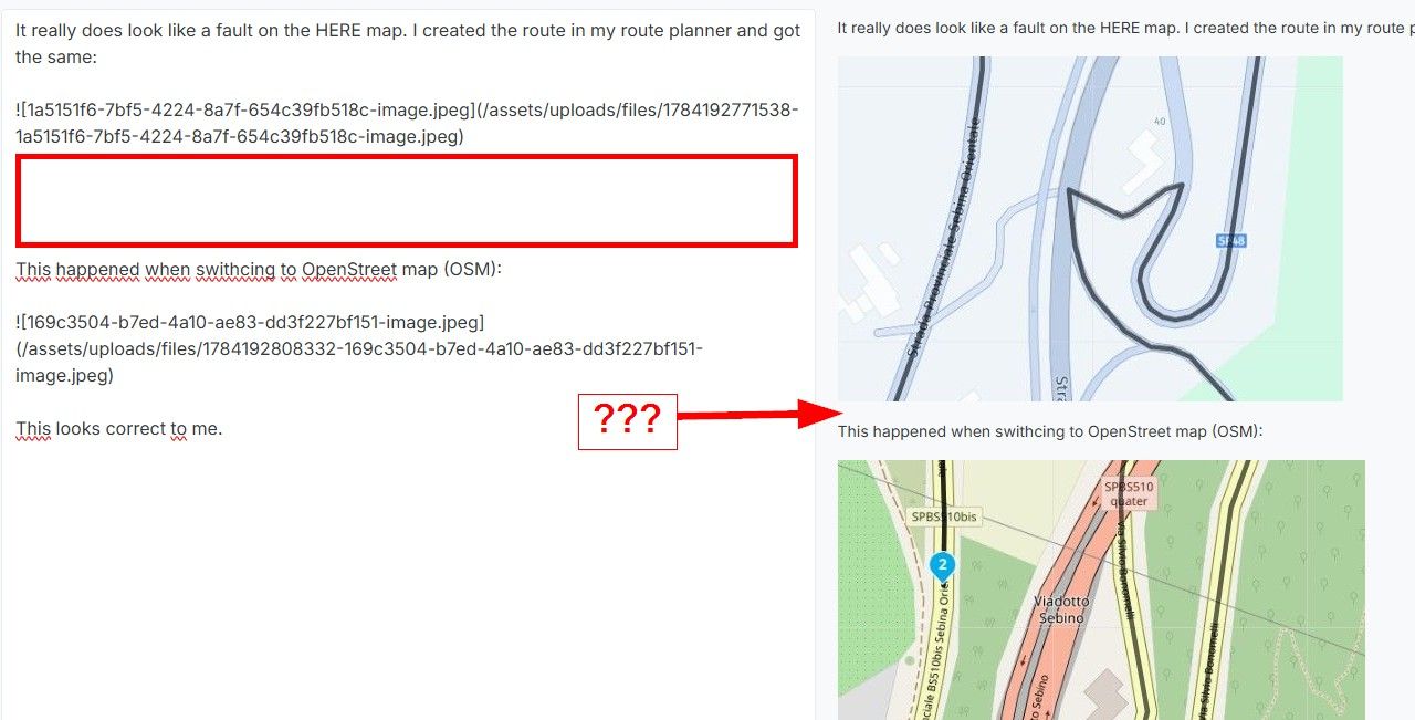
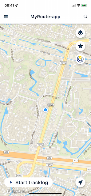
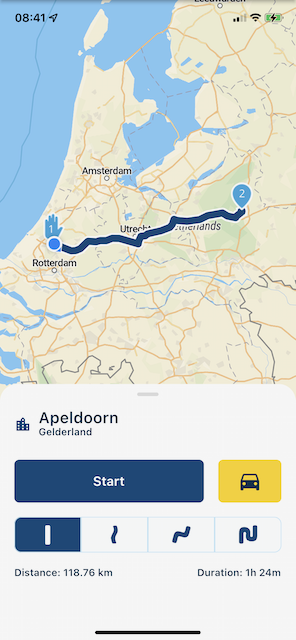
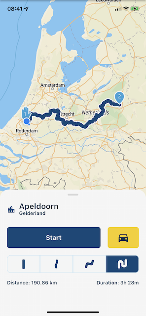
I do note that if you select OpenStreeMaps you can go to the Toolkit and select Curves in the Routing Options. This appears to be a silver subscription feature (I don't have that) and I don't see any information on it in the documentation - so I can't see how it really works. Since I generally have it set to HERE maps, I didn't see this.
@Tim-Thompson See the attached screenshot. Use the search functionality in the app (on the map, top right).
-
Another comment about sorting route list...
If you are looking at the route list on the web based Route Lab (on your mobile device via a browser), your sorting is limited. In portrait view, you only have access to sort by name because this is the only option that is in view. Rotating to landscape gives you access to Type, Privacy, and Changed. Distance and Duration are still cut off and appear inaccessible.
@Tim-Thompson You are completely correct. Sorting in the Mobile browser view is much more limited. Something to improve later on
")
-
@ Allen ben ik wellicht te ambitieus als ik zou willen voorstellen om te vragen om zowel de mogelijkheid te hebben met track als met route kunnen te kunnen navigeren hehe. Als de app beide kan en beide manieren perfect gaan, dan zijn alle partijen tevreden!

@StefanHummelink
 Dit is inderdaad de bedoeling, zowel de 'volg de track' als een volledig dynamische 'turn-by-turn' navigatiemodus komen uiteindelijk in mobile terecht. De simpele 'volg de track' modus is niet alleen ontzettend handig voor de wandelaars en fietsers, maar ook voor bijvoorbeeld groepen motor- of autorijders die dicht op elkaar rijden: dan wil je als 'volger' wellicht niet eens al die instructies zien maar gewoon de geplande route.
Ook is het een mooie bijkomstigheid dat de app niet ineens kan denken dat er een file ontstaat en vervolgens allerlei gebruikers andere kanten uit gaat sturen. Dat is een veelgehoorde kritiek die ik gelukkig ook bij ieder ander platform voorbij zie komen. Wij komen daarbij overigens met een oplossing in de vorm van 'groepsritten'.
 This is indeed the intention, both the 'follow the track' and a fully dynamic 'turn-by-turn' navigation mode will eventually end up in mobile. The simple 'follow the track' mode is not only very useful for walkers and cyclists, but also for example for groups of motorcyclists or car drivers who drive close to each other: then you as a 'follower' may not even want to see all those instructions but just the planned route.
It is also a nice side effect that the app cannot suddenly think that a traffic jam is created and then send all kinds of users in other directions. That is a frequently heard criticism that I fortunately also see on every other platform. We also come up with a solution in the form of 'group rides'.
-
@StefanHummelink
Dit is inderdaad de bedoeling, zowel de 'volg de track' als een volledig dynamische 'turn-by-turn' navigatiemodus komen uiteindelijk in mobile terecht. De simpele 'volg de track' modus is niet alleen ontzettend handig voor de wandelaars en fietsers, maar ook voor bijvoorbeeld groepen motor- of autorijders die dicht op elkaar rijden: dan wil je als 'volger' wellicht niet eens al die instructies zien maar gewoon de geplande route.Ook is het een mooie bijkomstigheid dat de app niet ineens kan denken dat er een file ontstaat en vervolgens allerlei gebruikers andere kanten uit gaat sturen. Dat is een veelgehoorde kritiek die ik gelukkig ook bij ieder ander platform voorbij zie komen. Wij komen daarbij overigens met een oplossing in de vorm van 'groepsritten'.
This is indeed the intention, both the 'follow the track' and a fully dynamic 'turn-by-turn' navigation mode will eventually end up in mobile. The simple 'follow the track' mode is not only very useful for walkers and cyclists, but also for example for groups of motorcyclists or car drivers who drive close to each other: then you as a 'follower' may not even want to see all those instructions but just the planned route.It is also a nice side effect that the app cannot suddenly think that a traffic jam is created and then send all kinds of users in other directions. That is a frequently heard criticism that I fortunately also see on every other platform. We also come up with a solution in the form of 'group rides'.
@Timo-Martosatiman-MRA said in Suggestions:
@StefanHummelink
Ook is het een mooie bijkomstigheid dat de app niet ineens kan denken dat er een file ontstaat en vervolgens allerlei gebruikers andere kanten uit gaat sturen. Dat is een veelgehoorde kritiek die ik gelukkig ook bij ieder ander platform voorbij zie komen. Wij komen daarbij overigens met een oplossing in de vorm van 'groepsritten'.Dit klinkt mij in de oren als de app van de Waze routeplanner. Die waarschuwt je ook als er voor je een incident gebeurt. Top optie

-
 undefined MyRoute-app community pinned this topic on
-
Woosh. Topic is now locked.

Please refer to the amended rules on page 1. i.e: make new topics for suggestions so we can keep it organized.
Thanks!
-
undefined MyRoute-app community locked this topic on
-
undefined MyRoute-app community unpinned this topic on
-
undefined MyRoute-app community moved this topic from [Beta] The MyRoute-app on
Hello! It looks like you're interested in this conversation, but you don't have an account yet.
Getting fed up of having to scroll through the same posts each visit? When you register for an account, you'll always come back to exactly where you were before, and choose to be notified of new replies (either via email, or push notification). You'll also be able to save bookmarks and upvote posts to show your appreciation to other community members.
With your input, this post could be even better 💗
Register Login-
4977
-
615110
-
06121
-
023479
-
0357
-
1957.4k
-
03126
-
018710