Trip Planning - Overlay Mark Up
-
Hi,
When I'm trip planning for multi-way trips I will generally create an overall route and then later break up into individual days.
In that initial stage, it would be really useful if I could annotate the map with lines, text and area fills. I realise I can do this on Google Maps, but it would be really helpful to be able to do this in the route planner. The annotations would be an overlay only and not part of the routing or the export of the route.
Do you have any plans to implement such an option or have I missed the feature?
Thanks
Steve
-
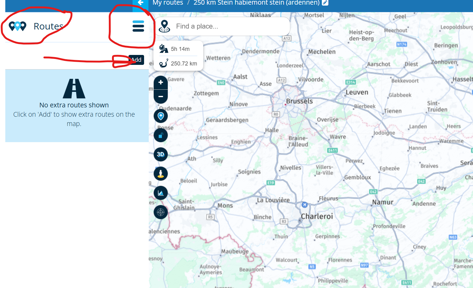
When you open one of the route you made klick on the hamburger menu on the left side and klick on routes en you can add the other routes to you're open route!
-
Hi,
When I'm trip planning for multi-way trips I will generally create an overall route and then later break up into individual days.
In that initial stage, it would be really useful if I could annotate the map with lines, text and area fills. I realise I can do this on Google Maps, but it would be really helpful to be able to do this in the route planner. The annotations would be an overlay only and not part of the routing or the export of the route.
Do you have any plans to implement such an option or have I missed the feature?
Thanks
Steve
Hi @Steve-James I don't believe you have missed anything & as far as I know such a feature is not on the radar for the near future, maybe on some distant plan / wish list
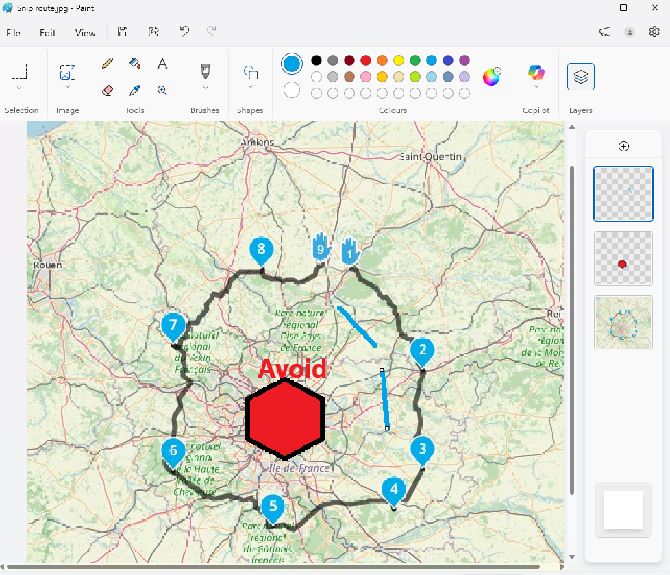
My suggestion to achieve sort of what you are after, all be it not within MRA, would be to use the windows Snip tool to clip a picture of your route.
Open this picture in MS Paint & then use the Layers function to add each individual set of lines, areas or text.Use Layers so you can update the base route map when it changes & remove stuff thats out of date or errors
-
Hi, Leike and Brian,
Thanks for your suggestions.
I'm typically looking at routes that take about a week, so circa 2,000 miles.
I do use the overlay routes function, but that has a different purpose, although to some extent it could be used by creating 'non routes' that are in reality annotation.
The MS Paint option isn't directly open to me as I use a Mac, but It's possible to do similar things with Google Earth etc. and you are on the right lines. I'll have to mark up a Google Earth image with something similar. I was just thinking that it would be much better within the app as the information is there whilst you are planning.
Thanks again,
Steve
-
As explained above, it is possible.
Hardware
iPhone 12 pro (iOS 26.2.1)
iPad (7.Gen.) 18.7.3
Oukitel RT3 Pro (Andr. 14)
Wireless CarPlay mit (Elebest C650)
Wired CarPlay (SEAT Arona - 2021)
MRA Workshops in Deutsch sind hier zu finden -
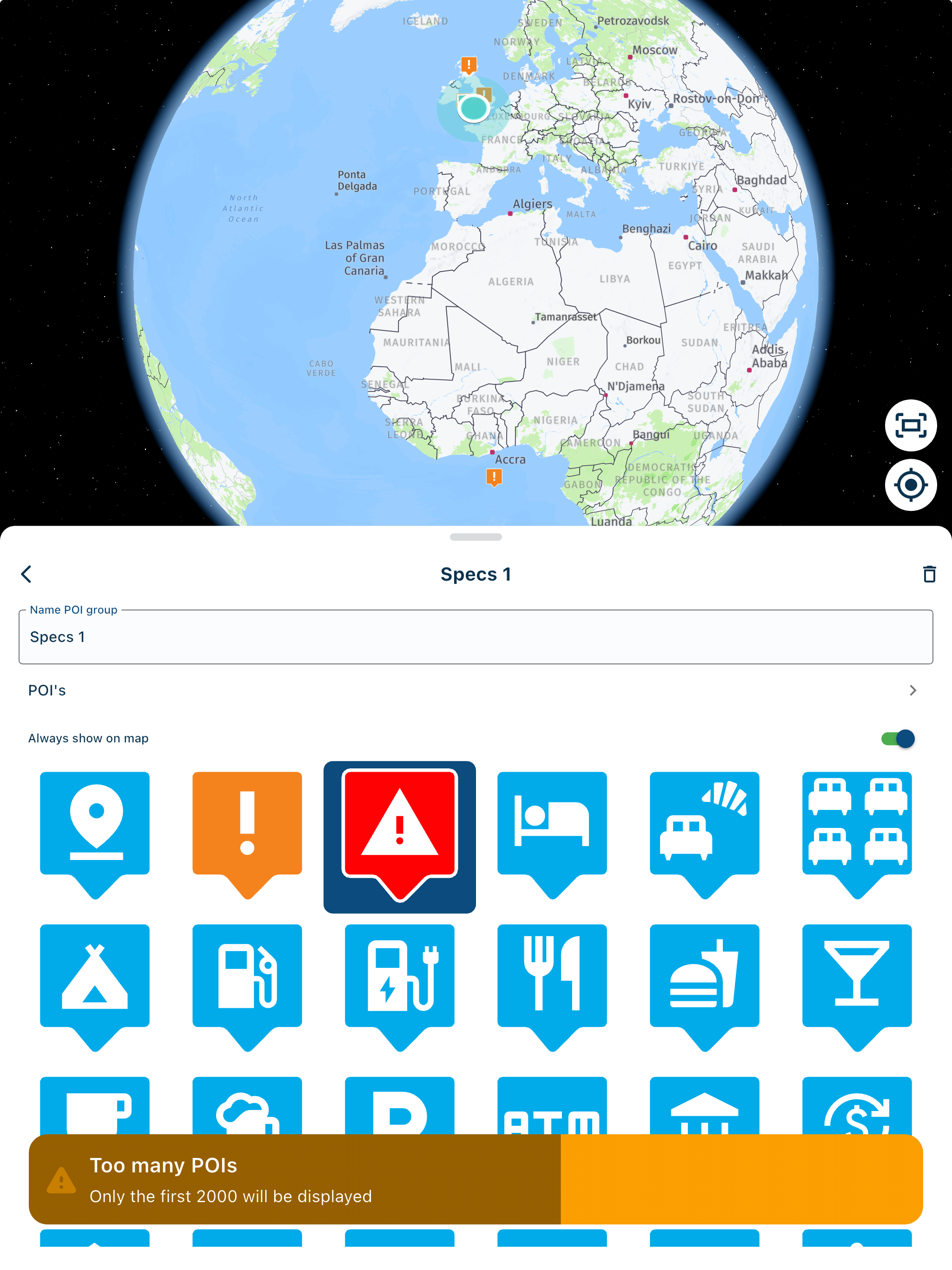
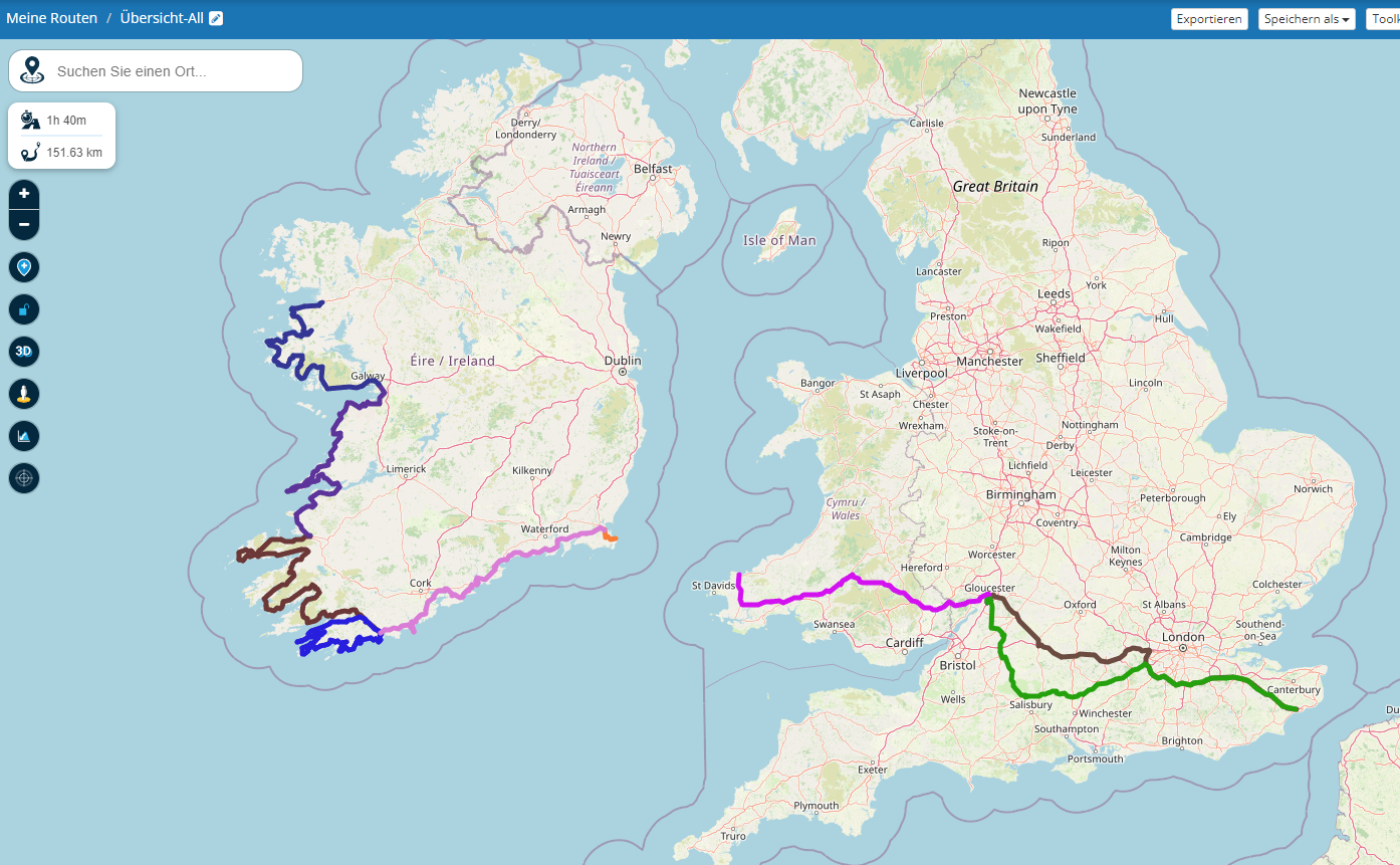
Each color is a day tour.
Hardware
iPhone 12 pro (iOS 26.2.1)
iPad (7.Gen.) 18.7.3
Oukitel RT3 Pro (Andr. 14)
Wireless CarPlay mit (Elebest C650)
Wired CarPlay (SEAT Arona - 2021)
MRA Workshops in Deutsch sind hier zu finden -
@Jörgen Hallo Jörgen,
Ich hab dazu eine Frage...
Ich kenne die Funktion Routen hinzufügen...
Allerdings habe ich immer das Problem dass ich bei der ersten Route welche ich als Ausgangspunkt nehme immer die gesetzen Wegpunkte noch sehe, bei den hinzugefügten Routen erscheint dann der Track(ohne Wegpunkte)
Wie schaffst Du es immer nur den Track zu sehen?Danke vorab.
Gruß
PeterBMW R 1250 GS
MRA Navigation & SilverFox C1 Controller
DMD-NOR7E 7"
SPC Universal mount
Motorola Edge 40 "offline"
Sena SLR 3
Sena 50 R -
@Jörgen Hallo Jörgen,
Ich hab dazu eine Frage...
Ich kenne die Funktion Routen hinzufügen...
Allerdings habe ich immer das Problem dass ich bei der ersten Route welche ich als Ausgangspunkt nehme immer die gesetzen Wegpunkte noch sehe, bei den hinzugefügten Routen erscheint dann der Track(ohne Wegpunkte)
Wie schaffst Du es immer nur den Track zu sehen?Danke vorab.
Gruß
Peter@Peter-Zehentreiter starte eine neue Route, mit nur 1 Waypoint, meinetwegen in Australien. Dann kannst du danach die Routen hinzufügen und siehst weiterhin keine detaillierte Route
")
Met andere apps maak je een route, met MRA componeer je een route!
Ducati Monster 1200 met Garmin Zümo XT
Fiat 124 Spider/Camper Dethleffs met Navigation-App op Samsung Tab Active4 Pro
MRA Lifetime Gold -
@Jörgen Hallo Jörgen,
Ich hab dazu eine Frage...
Ich kenne die Funktion Routen hinzufügen...
Allerdings habe ich immer das Problem dass ich bei der ersten Route welche ich als Ausgangspunkt nehme immer die gesetzen Wegpunkte noch sehe, bei den hinzugefügten Routen erscheint dann der Track(ohne Wegpunkte)
Wie schaffst Du es immer nur den Track zu sehen?Danke vorab.
Gruß
Peter@Peter-Zehentreiter said in Trip Planning - Overlay Mark Up:
@Jörgen Hallo Jörgen,
Ich hab dazu eine Frage...
Ich kenne die Funktion Routen hinzufügen...
Allerdings habe ich immer das Problem dass ich bei der ersten Route welche ich als Ausgangspunkt nehme immer die gesetzen Wegpunkte noch sehe, bei den hinzugefügten Routen erscheint dann der Track(ohne Wegpunkte)
Wie schaffst Du es immer nur den Track zu sehen?Danke vorab.
Gruß
PeterEine Neue leere Route erstellen, z.B. "Alle Tage der Tour XYZ".
Dann in dieser nur die einzelnen Tage (Routen) über "Routen hinzufügen" hinzufügen.
Wenn man möchte, kann man in der Routen Information und Beschreibung noch was zu den Farben usw. sagen. -
@Peter-Zehentreiter starte eine neue Route, mit nur 1 Waypoint, meinetwegen in Australien. Dann kannst du danach die Routen hinzufügen und siehst weiterhin keine detaillierte Route
@Lex.Kloet.RX @Jörgen
Hallo Ihr zwei,
herzlichen Dank für den Tip, so einfach… und doch wäre ich da nicht drauf gekommen. -
@Jörgen
Hi,
Thanks for responding. I already do what you have suggested. It is more the broader scale, a bit like Brian McG suggests but think for marking up thoughts for a planned route say from UK to Spain, tour around and then back. Putting some areas to include, marking towns to visit and adding notes. That sort of thing.Steve
-
Just incase anyone is interested, my latest work around is to use Google's mymaps, to overlay annotation on a google maps background with goolemaps functionality. You can share the overlay with others.
I've added a screenshot of the overall, plus a couple of 'zoom ins'. Note you can add information to the points, if you look at the ferry port icon that I added, I have been able to link to the ferry sailings schedule. All useful stuff in the early stages of planning, especially if sharing.
It's a shame that I can't select the overlay to be visible when planning on myrouteapp.
To do it this way would make implementation easier.
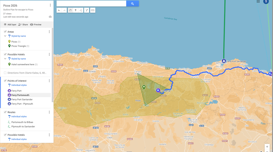
Steve
Hello! It looks like you're interested in this conversation, but you don't have an account yet.
Getting fed up of having to scroll through the same posts each visit? When you register for an account, you'll always come back to exactly where you were before, and choose to be notified of new replies (either via email, or push notification). You'll also be able to save bookmarks and upvote posts to show your appreciation to other community members.
With your input, this post could be even better 💗
Register Login-
014214
-
1936.2k
-
0466
-
0243
-
17438.7k
-
255613.0k
-
0948
-
0127