Skip to content
  • Categories
  • Recent
  • Popular
  • Support
  • MyRoute-app
Collapse
Brand Logo

MRA Community Forum

  1. Home
  2. General Discussion
  3. Keeping routes from my route app identical with my GARMIN ZUMO XT2

Keeping routes from my route app identical with my GARMIN ZUMO XT2

Scheduled Pinned Locked Moved General Discussion
14 Posts 5 Posters 524 Views 3 Watching
  • Oldest to Newest
  • Newest to Oldest
  • Most Votes
Reply
  • Reply as topic
Log in to reply
This topic has been deleted. Only users with topic management privileges can see it.
  • Aggelos Minoudisundefined Aggelos Minoudis

    Thank you Hans I'll give it a try. By the way does Here map has hybrid view cause I like to see the terrain when I design a route..By the way MRA route planner is top I think in designing routes And planning trips

    Hans van de Ven MR.MRAundefined Offline
    Hans van de Ven MR.MRAundefined Offline
    Hans van de Ven MR.MRA
    RouteXpert
    wrote last edited by
    #4

    @Aggelos-Minoudis
    Yes, see the map layers

    Garmin Zumo XT2/XT/BMW Connected Ride Navigator/MyRouteapp (The App)
    Een dag niet gelachen is een dag niet geleefd / Een route is net zo goed als deze uitgezet is.

    1 Reply Last reply
    0
    • Aggelos Minoudisundefined Offline
      Aggelos Minoudisundefined Offline
      Aggelos Minoudis
      wrote last edited by
      #5

      Dear Hans, I've just transferred a route from MYroute to Garmin as a gps 1.1 file and they re identical. Please can you tell me on Garmin device how to make the track visible? ill turn the recalculation off. Also what do you mean when the route points are on a technical good place on the road to set recalc. on again? Why shouldn't I leave it on all the time? Thanx for your patience

      1 Reply Last reply
      0
      • Hans van de Ven MR.MRAundefined Offline
        Hans van de Ven MR.MRAundefined Offline
        Hans van de Ven MR.MRA
        RouteXpert
        wrote last edited by
        #6

        Go to tracks on your device, open the track you want to edit, click on make visible. Place points after a roundabout, intersection or road junction

        Garmin Zumo XT2/XT/BMW Connected Ride Navigator/MyRouteapp (The App)
        Een dag niet gelachen is een dag niet geleefd / Een route is net zo goed als deze uitgezet is.

        1 Reply Last reply
        0
        • Aggelos Minoudisundefined Offline
          Aggelos Minoudisundefined Offline
          Aggelos Minoudis
          wrote last edited by
          #7

          Hi again , I managed to have visible the track and the route when I put both the track and the route at the same file in collections. Now I see the magenta line is not identical with the track line. What do I do now when I’ll navigate? Can I follow the track line at the points that two lines divide each other ? Or only the magenta line is driveable ? Thnx again

          1 Reply Last reply
          0
          • Marinus van Deudekomundefined Offline
            Marinus van Deudekomundefined Offline
            Marinus van Deudekom
            Valued contributor
            wrote last edited by
            #8

            The trackline would be the indication if you’re on the wright track

            Honda Goldwing GL1500,
            Honda Silverwing GL 650
            DMD2 T865X 8 inch Android tablet using MRA next for navigation
            Garmin XT (almost in the cupboard)
            Samsung S20FE mounted on a Quadlock and using Android Auto in my car

            1 Reply Last reply
            0
            • Aggelos Minoudisundefined Offline
              Aggelos Minoudisundefined Offline
              Aggelos Minoudis
              wrote last edited by
              #9

              Marinus hi ,
              So when magenta drives me somewhere else, I’ll follow the track line right ?

              Marinus van Deudekomundefined 1 Reply Last reply
              0
              • Aggelos Minoudisundefined Aggelos Minoudis

                Marinus hi ,
                So when magenta drives me somewhere else, I’ll follow the track line right ?

                Marinus van Deudekomundefined Offline
                Marinus van Deudekomundefined Offline
                Marinus van Deudekom
                Valued contributor
                wrote last edited by
                #10

                @Aggelos-Minoudis yep but normally the both must be close to one another

                Honda Goldwing GL1500,
                Honda Silverwing GL 650
                DMD2 T865X 8 inch Android tablet using MRA next for navigation
                Garmin XT (almost in the cupboard)
                Samsung S20FE mounted on a Quadlock and using Android Auto in my car

                1 Reply Last reply
                0
                • Aggelos Minoudisundefined Offline
                  Aggelos Minoudisundefined Offline
                  Aggelos Minoudis
                  wrote last edited by
                  #11

                  Thanks a lot Marinus!

                  Guzzistundefined 1 Reply Last reply
                  0
                  • Guztundefined Offline
                    Guztundefined Offline
                    Guzt
                    wrote last edited by
                    #12

                    You probably use the Tread app to synchronise your routes. If you do, they will always be different as the Tread app recalculates your route. Save your route gpx 1.1 directly on the SD in the XT2 and import it using the app.

                    Aggelos Minoudisundefined 1 Reply Last reply
                    0
                    • Aggelos Minoudisundefined Aggelos Minoudis

                      Thanks a lot Marinus!

                      Guzzistundefined Offline
                      Guzzistundefined Offline
                      Guzzist
                      Valued contributor
                      wrote last edited by
                      #13

                      @Aggelos-Minoudis hmmm - looks like, you need to learn/understand basics how route planning and navigation works. May I help you by easy words:

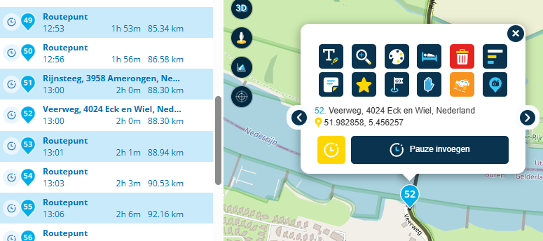
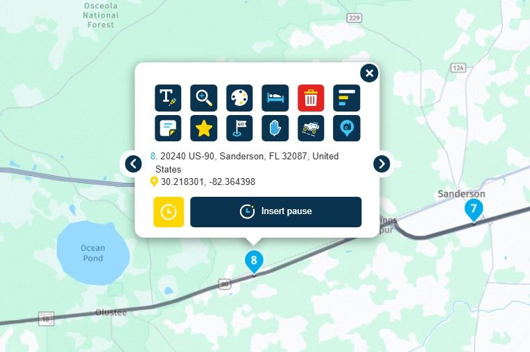
                      A route is a collection of points, defined by gps coordinates and called exactly as "rtept" (route points). A navigation app or device calculates a direction from one point to the next one, using street information in a map. And presenting it as a line as overlay on the map. Garmin is showing this line mostly in purple colour, with orange flag icons for each route point. Mostly navigation apps/devices can only handle limited amount of route points.
                      Very often, people are talking about this points as waypoints; but this is technically not correct.

                      A track is also a collection of points, defined by gps coordinates but called exactly as "trkpt" (track points). A navigation app or device is not calculating a direction from one point to the next point. But is presenting it as a line as overlay on the map. Garming let you select o colour in the settings, and only the first- and the last point will be presented in map. Usage of track points is mostly not limited.
                      A track is usually a recorded file during a ride.

                      Additionally you can enter POI (Point's of Interrest) out of a collection (gas stations, hotels, restaurants, etc.) - these are called exactly as "wpt" (way points). A navigation app or device is not calculating a direction from one point to the next point. But is presenting such points as a icon as overlay on the map.

                      You can save a created route in MRA-Routeplanner as gpx 1.1 fike at your computer. Then open it as simple text file (may by notepad) - then you can see it: in the file, there is the route as well as the track. And if you have entered POI - there are also included in gpx file.

                      If you are using MyRoute-App for navigation, you could be lucky, because this app is also able to guide/route you by a track!

                      If you are going to transmit a route or a track by gps file to a Garmin device, you can do this by USB, copy to SD-Card, Bluetooth or WiFi - based by device type. For a Gamin-XT, I mostly used the Garmin app "Drive" (Bluetooth). But Garmin has developed the system/app "Explore" (Wifi) resp. Thread App (Bluetooth), to be used for future - starting with Garmin XT2!
                      But you need to know: "Explore" is a route planning system and is calculating transmitted routes by its own algorithm. Effect: transmitted route to the device is mostly different to your original planned route!

                      If you switch on in your XT2 preferences, to populate both, route and track on screen. Then you will see probably a difference between track and route (because the track will never be recalculated). To prevent this, use more route points during planning. To not overspent capability of garmin device, use more "shaping points" and less "via points" in MRA-Routeplanner.

                      Nothing is impossible ;-)
                      In past: GARMIN Zumo 210->GARMIN Zumo 395->GARMIN XT=> now: DMD T865-X + MyRoute-App, LocusMaps, OsmAnd.
                      In past: GARMIN MapSource ->GARMIN BaseCamp->Tyre->Kurviger->Calimoto=> now: MRA-Routplanner.

                      1 Reply Last reply
                      0
                      • Guztundefined Guzt

                        You probably use the Tread app to synchronise your routes. If you do, they will always be different as the Tread app recalculates your route. Save your route gpx 1.1 directly on the SD in the XT2 and import it using the app.

                        Aggelos Minoudisundefined Offline
                        Aggelos Minoudisundefined Offline
                        Aggelos Minoudis
                        wrote last edited by
                        #14

                        @Guzt said in Keeping routes from my route app identical with my GARMIN ZUMO XT2:

                        You probably use the Tread app to synchronise your routes. If you do, they will always be different as the Tread app recalculates your route. Save your route gpx 1.1 directly on the SD in the XT2 and import it using the app.

                        Hi Guzt,
                        Thanx mate, but I don't use tread at all. I just export it from myrouteapp as gpx 1.1 to my Garmin XT2, I installed an app that MacBook sees my Garmin as an android device, so in Garmin xt2 file gpx I drop them there and they are automatically stored.

                        1 Reply Last reply
                        1
                        Reply
                        • Reply as topic
                        Log in to reply
                        • Oldest to Newest
                        • Newest to Oldest
                        • Most Votes


                        ACTIVE USERS
                        Marinus van Deudekomundefined
                        Marinus van Deudekom
                        Guzzistundefined
                        Guzzist
                        Hans van de Ven MR.MRAundefined
                        Hans van de Ven MR.MRA
                        Aggelos Minoudisundefined
                        Aggelos Minoudis
                        Guztundefined
                        Guzt
                        POPULAR TOPICS
                        • Routepunten overslaan zonder reden
                          M. Schrijverundefined
                          M. Schrijver
                          0
                          38
                          1.8k

                        • MRA User map
                          Jörgenundefined
                          Jörgen
                          2
                          5
                          104

                        • Future Developments
                          Con Hennekensundefined
                          Con Hennekens
                          1
                          20
                          513

                        • Points of Interest (POI) Questions
                          Leike Lodiersundefined
                          Leike Lodiers
                          0
                          4
                          95

                        • Mute / Silence / Ignore A Whole Forum Category / Section
                          Brian McGundefined
                          Brian McG
                          0
                          4
                          150

                        • Change Subscription Country
                          Nick Carthewundefined
                          Nick Carthew
                          0
                          2
                          43

                        • Routes van vrienden bekijken
                          Marinus van Deudekomundefined
                          Marinus van Deudekom
                          0
                          5
                          173

                        • Indicator arrow drifts all over the map.
                          Corjan Meijerinkundefined
                          Corjan Meijerink
                          0
                          9
                          348
                        MY GROUPS
                        • Login

                        • Login or register to search.
                        • First post
                          Last post
                        0
                        • Categories
                        • Recent
                        • Popular
                        • Support
                        • MyRoute-app