New update! (4.3.6) - offroad waypoints
-
@Con-Hennekens No not really

Starting online and then going offline won't work result in issues.However once you are offline there only needs to be the slightest deviation of the route to require internet for optimal experience. Even when recalculations are disabled and you rejoin the track, internally stuff is recalculated. Hence you'd ideally have internet.
@Corjan-Meijerink said in New update! (4.3.6) - offroad waypoints:
No not really
Starting online and then going offline won't work result in issues.Thanks for this correction. It is difficult (for me
) to understand that a track that has already been cached is being disregarded when a route (not track!) to the nearest trackpoint is calculated (which probably should not be done if recalculation is disabled anyway). Especially, like you mentioned to @Martin-Wilcke, the white line (thus the original track in this case) is not changing. I am clearly missing something I am just an enthusiastic MRA user, and hope you will be one too!
Most motorcycle problems are caused by the nut that connects the handlebar to the saddle.
Check out RideSleepRepeat.eu, a biker community for sharing stays across Europe
-
@Corjan-Meijerink said in New update! (4.3.6) - offroad waypoints:
No not really
Starting online and then going offline won't work result in issues.Thanks for this correction. It is difficult (for me
) to understand that a track that has already been cached is being disregarded when a route (not track!) to the nearest trackpoint is calculated (which probably should not be done if recalculation is disabled anyway). Especially, like you mentioned to @Martin-Wilcke, the white line (thus the original track in this case) is not changing. I am clearly missing something I certainly haven't completely understood everything yet, but I know how track/route-as-track navigation basically works. If you like, we can share our thoughts.
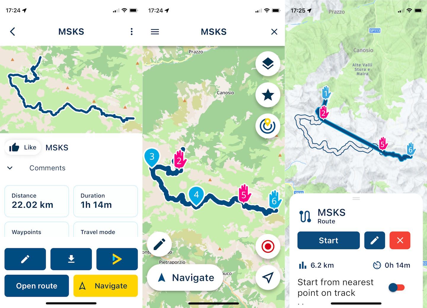
Here is a good example (posted initially by @UwB), the "Maira-Stura Kammstrasse" in the Alps:
https://www.myrouteapp.com/en/social/route/10444583?mode=share
The part between VP 2 and 5 is routable with OSM/TT, but not with HERE:
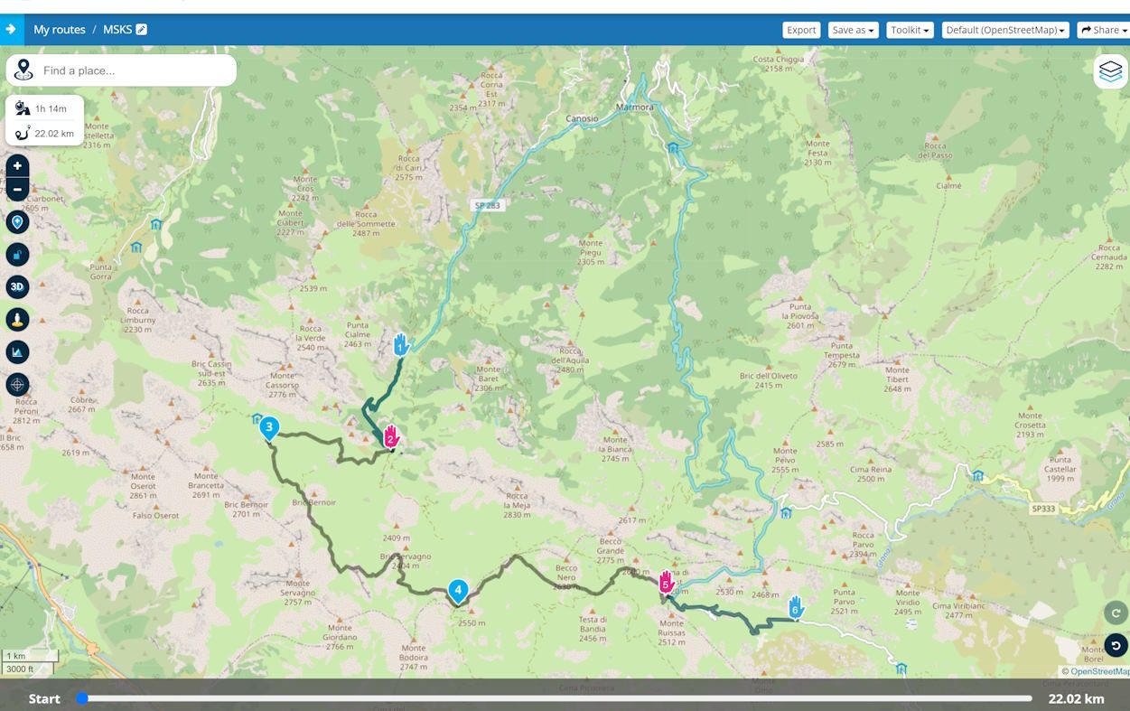
The route is stored internally in MRA so that the calculated path is completely modelled (I don't know how this works technically; it's probably similar to Basecamp with hidden SPs).
In MRA NN, the route is therefore displayed in its original shape both in the preview and after opening.
When it is started for "route-as-track" navigation, it is treated as a track and is not recalculated - not at the beginning or during navigation (white line).
However, a new route (blue line) is calculated, which follows the track as closely as possible. If the route deviates too far from the track, it is displayed in this area as the crow flies, and no information (turn instructions, ETAs, distances) is shown during navigation.
I suspect the issues discussed here arise when you rejoin the route at VP5. The actual path does not have to be re-determined in terms of "re-routing", but something may have to be "re-calculated" to show the adjusted ETAs and distances (and maybe turn instructions as well) - even if "auto-recalc" is turned off.
Do you agree so far? What are your thoughts?
-
Hi all!
")
It is time for a new update!

This version is all about the support of offroad waypoints!Offroad waypoints
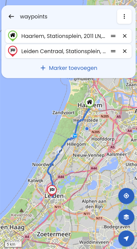
Within the online MRA Routeplanner you can very conveniently mark some waypoints as "offroad". The main idea behind this is to skip a section of road that is unknown to the selected routing engine (HERE / TomTom / OSM). Ideal to avoid roads marked as closed (either seasonal or long term damaged) or things such as ferries.
The app had no idea how to work with these "offroad" waypoints and just treated them as normal ones. Causing the route to be different than planned

As of now, the app does support the offroad waypoints!

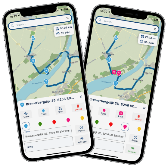
In the planner you can edit any route you like and mark any waypoint as offroad! Just as in the website.

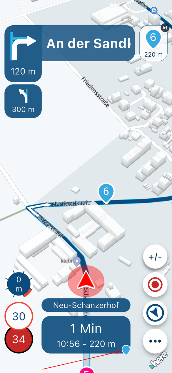
If you then choose to navigate a route with offroad waypoints, you will see straight lines on the offroad sections. Just as planned!

These sections will be made extra clear with a nice dashed line.
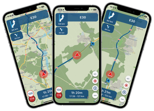
While navigating over an offroad section, some things are however different:
- No visual instructions
- No audio instructions
- Possible loss of ETA information
- Automatic recalculations disabled
You don't need them anyway, as you're offroad.
Android Auto / CarPlay do not support the disabling of some visual elements. This can result in a slightly suboptimal experience when on an offroad section.As offroad waypoints rely on track navigation under the hood, you do need to be online for an optimal experience. When offline, you will receive an appropriate warning
By introducing this feature in the app, we now support all the crucial features that the website has
Compass changes
A lot of users were unaware what the selected camera mode was. Not entirely their fault as the icon remained the same and you did not receive any other confirmation.
Now when tapping the compass, the icon will change based on the selected mode. Also, you will receive a short textual confirmation of the selected camera mode.
Bluetooth controller changes
- Support for Remotek firmware version 2.x
- Fixed issue with BMW Carpe Iter controller
Minor fixes
- iPad export option
- Manual day / night changes from CarPlay / Android Auto changed the base map style incorrectly
- Missing pause icons
- Not showing the same warning multiple times
Minor changes
- Added a loader in the in-app planner
- Not including current location when calculating routes that are far away
- Showing original route just before starting navigation (not only while navigating)
- Open route from RouteXpert library or activity feed by tapping the image
- Flow for starting routes created in a map other than HERE
Android specific changes
- Hide the notification bar and on screen navigation buttons when navigating
- Support for more "intents" ensuring MyRoute-app is displayed more often as supported app to navigate with (such as with DMD2)
What's next
That's it for now!
We are currently working on a complete rework of the home screen of the app Expecting a release of this somewhere in March.The idea behind this is to improve the visual appearance of the app, less clicks for the user, smoother transition to navigation and offline availability of the home screen maps too.
Cheers,
Corjan@Corjan-Meijerink said in New update! (4.3.6) - offroad waypoints:
Fixed issue with BMW Carpe Iter controller
@Corjan-Meijerink Which issues exactly did you fix?
Because there where a few. The extra bar-buttons didn"t react properly and trying to go trough the menu the [ENTER] by moving the wonderwheel to the right didn't work.
Neverteless i still am impressed by al the updates and improvements you guys make.
BMW R1250 GSA Ultimate Edition
Garmin XT3
Samsung S25+
Enthousiast MRA/MRA Next gebruiker -
Manual day / night changes from CarPlay / Android Auto changed the base map style incorrectly
Thank you for fixing this! It eliminates an annoying bug I encountered numerous times. And I can confirm this is no longer the case.

-
Hi all!
It is time for a new update!
This version is all about the support of offroad waypoints!Offroad waypoints
Within the online MRA Routeplanner you can very conveniently mark some waypoints as "offroad". The main idea behind this is to skip a section of road that is unknown to the selected routing engine (HERE / TomTom / OSM). Ideal to avoid roads marked as closed (either seasonal or long term damaged) or things such as ferries.
The app had no idea how to work with these "offroad" waypoints and just treated them as normal ones. Causing the route to be different than planned
As of now, the app does support the offroad waypoints!
In the planner you can edit any route you like and mark any waypoint as offroad! Just as in the website.
If you then choose to navigate a route with offroad waypoints, you will see straight lines on the offroad sections. Just as planned!
These sections will be made extra clear with a nice dashed line.
While navigating over an offroad section, some things are however different:
- No visual instructions
- No audio instructions
- Possible loss of ETA information
- Automatic recalculations disabled
You don't need them anyway, as you're offroad.
Android Auto / CarPlay do not support the disabling of some visual elements. This can result in a slightly suboptimal experience when on an offroad section.As offroad waypoints rely on track navigation under the hood, you do need to be online for an optimal experience. When offline, you will receive an appropriate warning
By introducing this feature in the app, we now support all the crucial features that the website has
Compass changes
A lot of users were unaware what the selected camera mode was. Not entirely their fault as the icon remained the same and you did not receive any other confirmation.
Now when tapping the compass, the icon will change based on the selected mode. Also, you will receive a short textual confirmation of the selected camera mode.
Bluetooth controller changes
- Support for Remotek firmware version 2.x
- Fixed issue with BMW Carpe Iter controller
Minor fixes
- iPad export option
- Manual day / night changes from CarPlay / Android Auto changed the base map style incorrectly
- Missing pause icons
- Not showing the same warning multiple times
Minor changes
- Added a loader in the in-app planner
- Not including current location when calculating routes that are far away
- Showing original route just before starting navigation (not only while navigating)
- Open route from RouteXpert library or activity feed by tapping the image
- Flow for starting routes created in a map other than HERE
Android specific changes
- Hide the notification bar and on screen navigation buttons when navigating
- Support for more "intents" ensuring MyRoute-app is displayed more often as supported app to navigate with (such as with DMD2)
What's next
That's it for now!
We are currently working on a complete rework of the home screen of the app Expecting a release of this somewhere in March.The idea behind this is to improve the visual appearance of the app, less clicks for the user, smoother transition to navigation and offline availability of the home screen maps too.
Cheers,
Corjan@Corjan-Meijerink Today was a test drive day, using Android Auto. When I pauzed the route, because of a fuel stop and the system came back on line The scree of Android Auto didn't show the map any more. The directions, speed and ETA were displayed. The audio was still working. I had to reboot the system to get the map visible again.
-
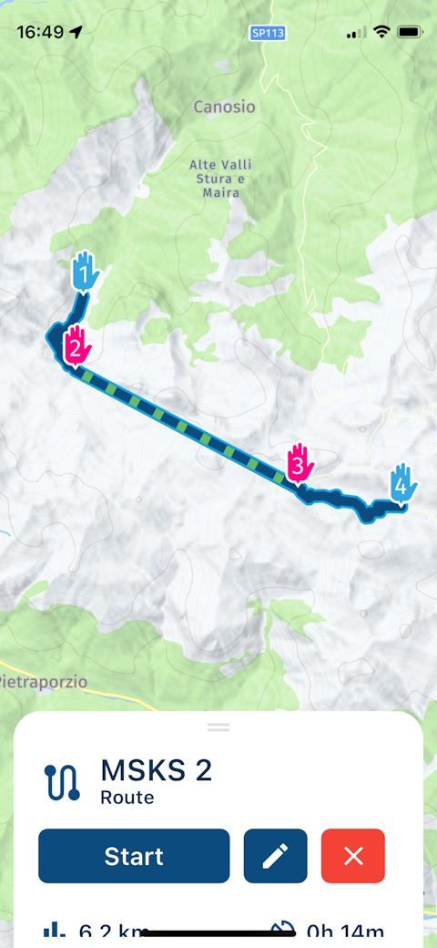
@Martin-Wilcke sounds correct indeed! Why exactly a straight line is drawn between 2 and 5 is a mystery to me. It should approach the track where possible.
My guess is that HERE really does not have a any suitable road in that area causing it to not calculate anything in that area.When rejoining at 5, it will all work as expected again and you can indeed manually follow the white line.
-
@Corjan-Meijerink said in New update! (4.3.6) - offroad waypoints:
Fixed issue with BMW Carpe Iter controller
@Corjan-Meijerink Which issues exactly did you fix?
Because there where a few. The extra bar-buttons didn"t react properly and trying to go trough the menu the [ENTER] by moving the wonderwheel to the right didn't work.
Neverteless i still am impressed by al the updates and improvements you guys make.
-
I certainly haven't completely understood everything yet, but I know how track/route-as-track navigation basically works. If you like, we can share our thoughts.
Here is a good example (posted initially by @UwB), the "Maira-Stura Kammstrasse" in the Alps:
https://www.myrouteapp.com/en/social/route/10444583?mode=share
The part between VP 2 and 5 is routable with OSM/TT, but not with HERE:
The route is stored internally in MRA so that the calculated path is completely modelled (I don't know how this works technically; it's probably similar to Basecamp with hidden SPs).
In MRA NN, the route is therefore displayed in its original shape both in the preview and after opening.
When it is started for "route-as-track" navigation, it is treated as a track and is not recalculated - not at the beginning or during navigation (white line).
However, a new route (blue line) is calculated, which follows the track as closely as possible. If the route deviates too far from the track, it is displayed in this area as the crow flies, and no information (turn instructions, ETAs, distances) is shown during navigation.
I suspect the issues discussed here arise when you rejoin the route at VP5. The actual path does not have to be re-determined in terms of "re-routing", but something may have to be "re-calculated" to show the adjusted ETAs and distances (and maybe turn instructions as well) - even if "auto-recalc" is turned off.
Do you agree so far? What are your thoughts?
@Martin-Wilcke, like Corjan already stated, it sounds about right. I don't think however this has to do with the online/offline track issue. We should probably keep this thread on-topic though.
I am just an enthusiastic MRA user, and hope you will be one too!
Most motorcycle problems are caused by the nut that connects the handlebar to the saddle.
Check out RideSleepRepeat.eu, a biker community for sharing stays across Europe
-
@Corjan-Meijerink This would be great if those features are working now. If have contacted you earlier with these little mallfunction.
BMW R1250 GSA Ultimate Edition
Garmin XT3
Samsung S25+
Enthousiast MRA/MRA Next gebruiker -
@Martin-Wilcke, like Corjan already stated, it sounds about right. I don't think however this has to do with the online/offline track issue. We should probably keep this thread on-topic though.
@Con-Hennekens said in New update! (4.3.6) - offroad waypoints:
I don't think however this has to do with the online/offline track issue. We should probably keep this thread on-topic though.
The link to this topic is @Corjan-Meijerink 's recommendation to stay online when navigating a track (where automatic recalculation is turned off by definition) and the question of when and why there is a need for a recalc anyway.
My guess: Every time you switch from "off-route" (where the track does not match the route) to "on-route" (when rejoining the route).
If I'd plan this route with HERE and an offroad waypoint
I'm pretty sure the result and the "issue" would be same. (I'd better use this version as an example, but it's less noticeable as no track is outlined.)
I am clearly missing something
I'm sorry my post was not helpful, as this was my main intention. What exactly are you missing?
-
@Corjan-Meijerink This would be great if those features are working now. If have contacted you earlier with these little mallfunction.
@Erik-Plaggenborg should work! I got confirmation from Carpe Iter today that everything works as intended.
-
@Con-Hennekens said in New update! (4.3.6) - offroad waypoints:
I don't think however this has to do with the online/offline track issue. We should probably keep this thread on-topic though.
The link to this topic is @Corjan-Meijerink 's recommendation to stay online when navigating a track (where automatic recalculation is turned off by definition) and the question of when and why there is a need for a recalc anyway.
My guess: Every time you switch from "off-route" (where the track does not match the route) to "on-route" (when rejoining the route).
If I'd plan this route with HERE and an offroad waypoint
I'm pretty sure the result and the "issue" would be same. (I'd better use this version as an example, but it's less noticeable as no track is outlined.)
I am clearly missing something
I'm sorry my post was not helpful, as this was my main intention. What exactly are you missing?
@Martin-Wilcke looks good and as designed!
Hello! It looks like you're interested in this conversation, but you don't have an account yet.
Getting fed up of having to scroll through the same posts each visit? When you register for an account, you'll always come back to exactly where you were before, and choose to be notified of new replies (either via email, or push notification). You'll also be able to save bookmarks and upvote posts to show your appreciation to other community members.
With your input, this post could be even better 💗
Register Login-
0993
-
1565
-
09197
-
08125
-
0327
-
37218
-
7281.7k
-
06112