Byway Open To All Traffic unrecognized.
-
This is all new to me so I'm hoping someone can help.
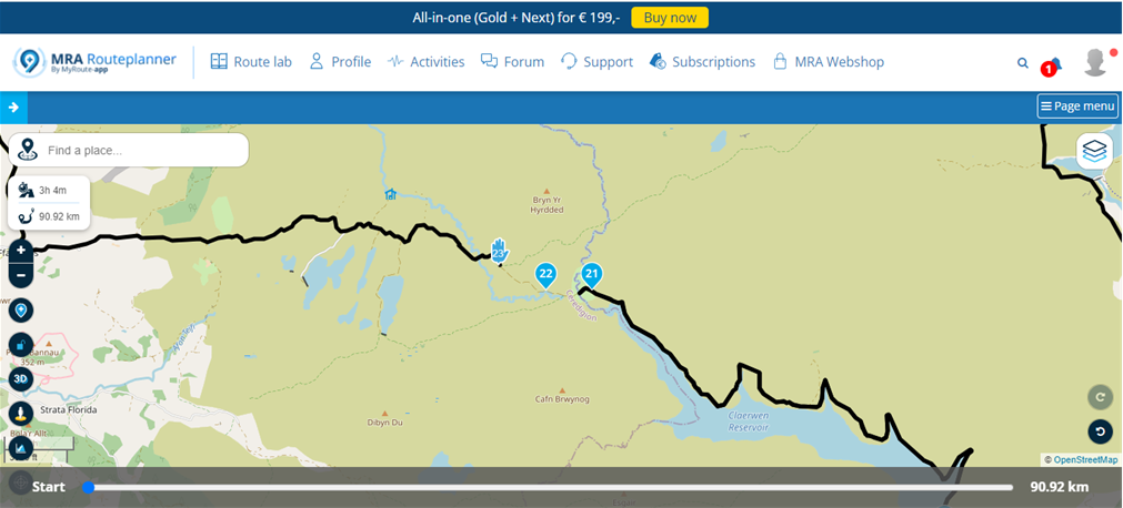
I am looking at MRA as an option for my route planning software and just having a quick play on the free option before jumping in, I like the look of it so far. I have this small issue and wondered if there is a work around. There is this small section of unpaved road (byway open to all traffic) around Claerwen reservoir that MRA doesn't recognise, is there a way of forcing it to take that route or would there be more options on the paid version to make it work? I could just end the route and start another at the other side but don't really want to do that as there could well be more tracks like this on the routes i want to plan. I currently use the Ordnance Survey app for mountain biking that will following any form of road/track/path etc but is not ideal for motorcycle routes. Is the OS map overlay available on the paid version?
I hope I can make this work as it looks like a good, useable tool.
Thanks -
This is all new to me so I'm hoping someone can help.
I am looking at MRA as an option for my route planning software and just having a quick play on the free option before jumping in, I like the look of it so far. I have this small issue and wondered if there is a work around. There is this small section of unpaved road (byway open to all traffic) around Claerwen reservoir that MRA doesn't recognise, is there a way of forcing it to take that route or would there be more options on the paid version to make it work? I could just end the route and start another at the other side but don't really want to do that as there could well be more tracks like this on the routes i want to plan. I currently use the Ordnance Survey app for mountain biking that will following any form of road/track/path etc but is not ideal for motorcycle routes. Is the OS map overlay available on the paid version?
I hope I can make this work as it looks like a good, useable tool.
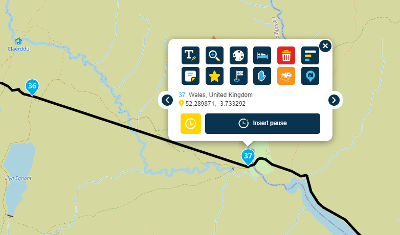
Thanks@Ben-Lewis Select the skip option for route point 23 (4x4 icon). I would also delete use skip for RP22 or delete it. And yes, the OSM overlay is available in the paid version.
-
This is all new to me so I'm hoping someone can help.
I am looking at MRA as an option for my route planning software and just having a quick play on the free option before jumping in, I like the look of it so far. I have this small issue and wondered if there is a work around. There is this small section of unpaved road (byway open to all traffic) around Claerwen reservoir that MRA doesn't recognise, is there a way of forcing it to take that route or would there be more options on the paid version to make it work? I could just end the route and start another at the other side but don't really want to do that as there could well be more tracks like this on the routes i want to plan. I currently use the Ordnance Survey app for mountain biking that will following any form of road/track/path etc but is not ideal for motorcycle routes. Is the OS map overlay available on the paid version?
I hope I can make this work as it looks like a good, useable tool.
Thanks@Ben-Lewis Here it is in the opposite direction. The skip option effectively switches of routing between two points and draws a straight line.
Always willing to help if I can.
Triumph Tiger 1200 XRT called Tina.
MRA Navigation Next and SilverFox BJ8 -
@Ben-Lewis Here it is in the opposite direction. The skip option effectively switches of routing between two points and draws a straight line.
@Nick-Carthew you absolute star, that's exactly what I was hoping was possible, I can cope with a short section of straight line. I guess I could always add more RPs and skip them the same to break the straight line up to following the track more closely if I really want to get it more accurate.
Ooh, I'm liking this now, it feels really user-friendly. I'm just not so keen on paying for the MRA Routeplanner and then again for the App to view it on my phone as I don't have a gps (yet!!).
-
@Nick-Carthew you absolute star, that's exactly what I was hoping was possible, I can cope with a short section of straight line. I guess I could always add more RPs and skip them the same to break the straight line up to following the track more closely if I really want to get it more accurate.
Ooh, I'm liking this now, it feels really user-friendly. I'm just not so keen on paying for the MRA Routeplanner and then again for the App to view it on my phone as I don't have a gps (yet!!).
@Ben-Lewis You can trial both Gold RoutePlanner and MRA Navigation Next free for two weeks. I'm not sure if there is a link for this anywhere but if you can't find one. Get in touch with Support by creating a new ticket and ask for a 2 week trial.
-
Rhiwnant to Claerwen (On and Off Road)
If you are serious about riding BOAT's in the UK (And probably the UK TET Routes also) you may want to consider using the OS Maps Software.
You can still use MRA to run the routes as Tracklogs which includes the Off-Road and On-Road sections.
You simply follow the line.https://www.myrouteapp.com/en/social/track/568605?mode=share
Hello! It looks like you're interested in this conversation, but you don't have an account yet.
Getting fed up of having to scroll through the same posts each visit? When you register for an account, you'll always come back to exactly where you were before, and choose to be notified of new replies (either via email, or push notification). You'll also be able to save bookmarks and upvote posts to show your appreciation to other community members.
With your input, this post could be even better 💗
Register Login-
023458
-
1432.4k
-
0446
-
2434
-
0377
-
06139
-
0239
-
210142