MRA Navigation Next first video!
-
Thank you for the first screens, it looks not bad.
I could add few remarks, what could be useful for me:- easy switching between distance/time to the end point/next stop point, or maybe to any selected stop point, if possible. I like Tomtom riders's way - one click to info to ending point, second click for next stop, etc.
- deleting next via point not by one click, because of possible mistakes - it could be by two clicks, so hidden under <...>,
- easy switching between navigation view and normal - whole route 2D view,
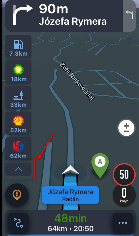
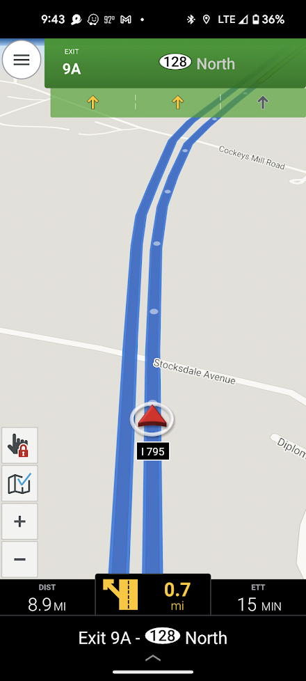
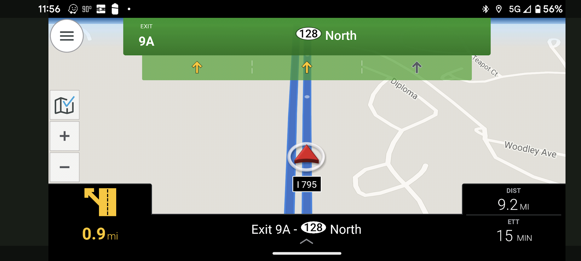
- easy showing POI line - nearest gas stations, restaurants etc, according to the individual settings. Also similar to Tomtom rider's line with next 50 km of the trip could be good, or maybe Sygic's view, with button for hiding the info if not needed:
-
And which options would you like to be able to turn on or off?
In the Zumo XT you have 20 options that you can display on the main screen.
Honestly, I only use 2, and that's the arrival time at a viapoint and the speed.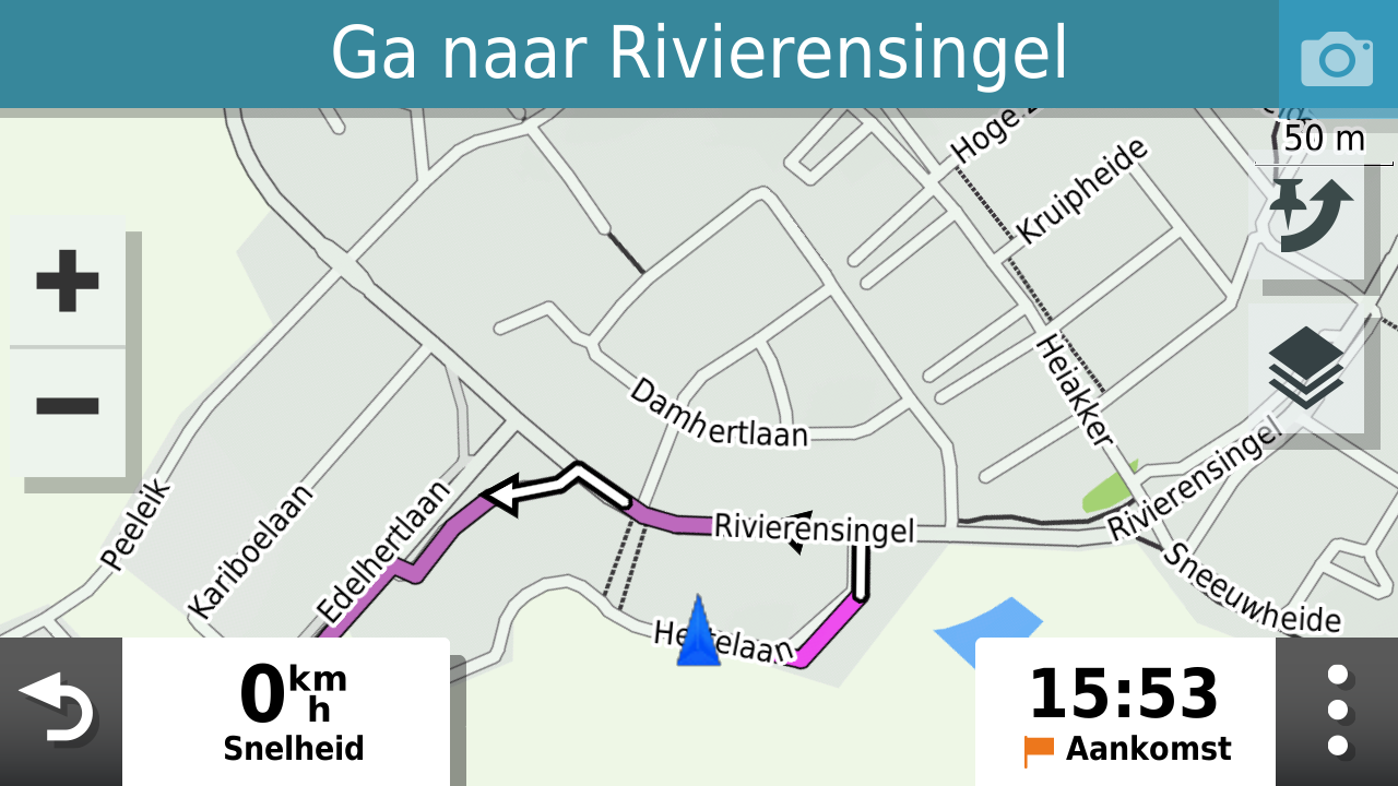
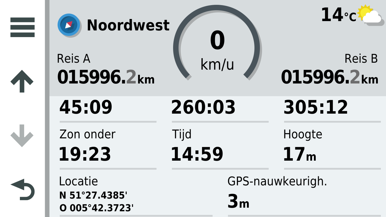
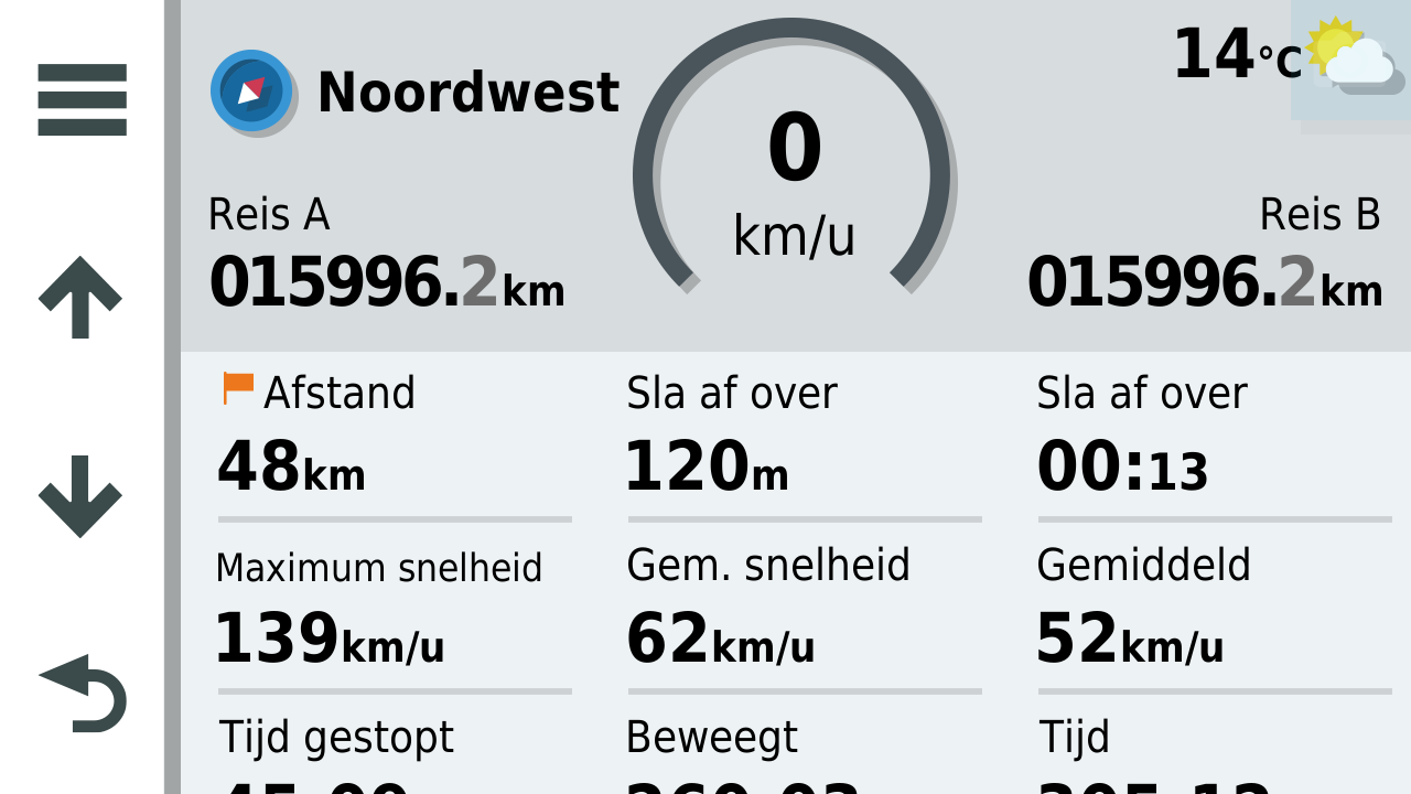
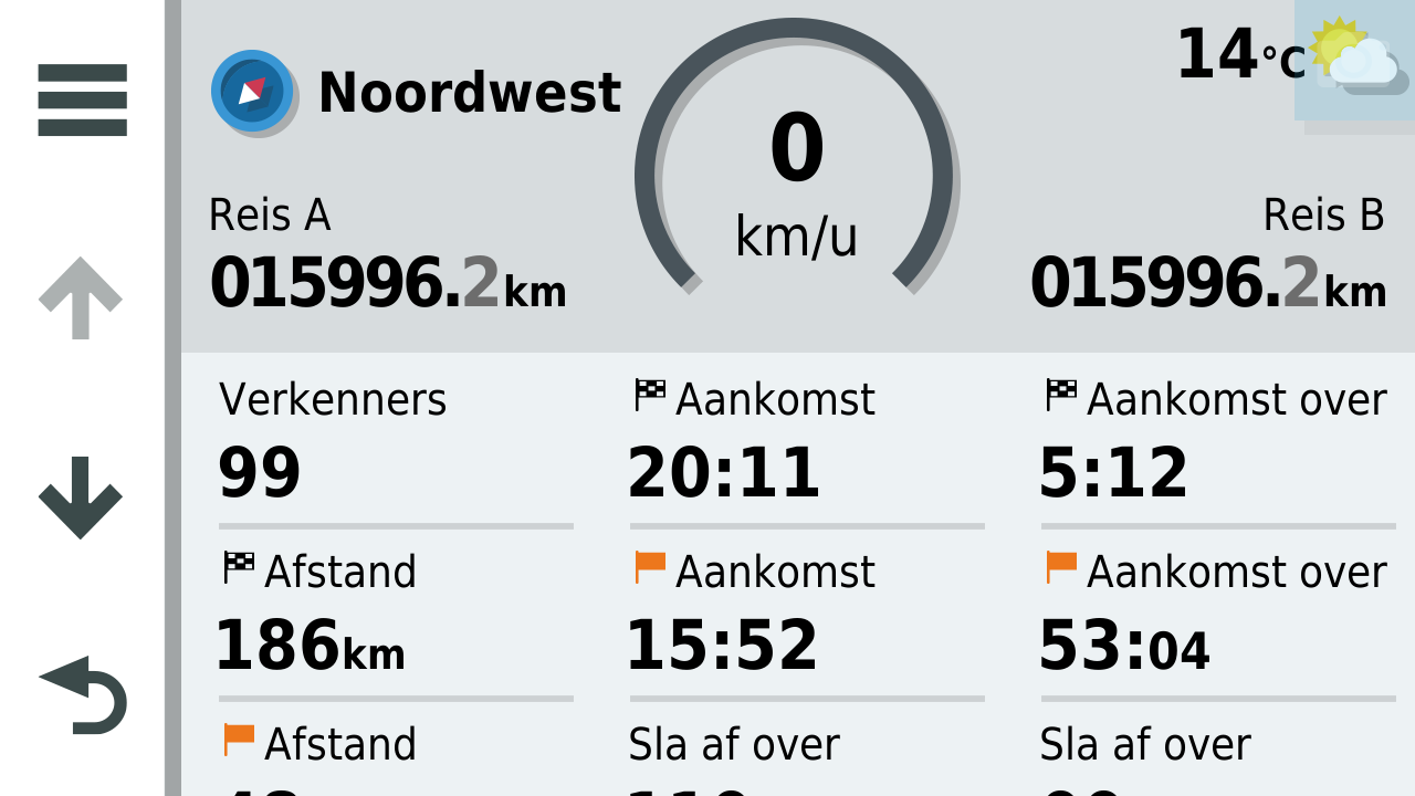
@Hans-van-de-Ven-MRA-Master, yes I know, twenty is a bit much. But speed is already on your dashboard (although een logican datfield to be shown). Nice info is Arrival time, Arrival distance, distance to next guidance (if you are going straight on a long road it is nice to know in advance so you can get into cruise mode
") ), Height is an item I very much like, Distance to next waypoint (not shaping point). I think I am forgetting some useful options here
), Height is an item I very much like, Distance to next waypoint (not shaping point). I think I am forgetting some useful options here -
More analysis from the guy who said it's too premature to analyze... Anyway...
Reflecting on a previous comment about banners/data/info fields obscuring that actual route/turns displayed on the map...
Yeah... I might agree a bit with that one. At this close proximity to a turn, the turn should clearly be in view. A comparison with Scenic...
I don't have a clip of Scenic in landscape, but the point can still be made. Scenic appears to keep the entire map and route displayed between the upper and lower data/info banners. Next appears to overlay these fields on top of the map allowing route/turn display info to be obscured.
Waze appears to approach this similar to Scenic - at least in portrait...
Waze's approach in Landscape is a bit different...

In either case, Waze doesn't seem to obscure the route/turn displayed on the map. You can clearly see what's coming well in advance.
Looking at another example... CoPilotGPS...
CoPilotGPS pretty much displays all the information in one field at the bottom, minimizing obscuring the map above. However, CoPilotGPS will violate this when it displays the road sign information (only displayed on highways/interstates) above the lane assist arrows. The road sign info in green seems redundant.
Anyways... perhaps food for thought.
-
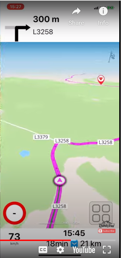
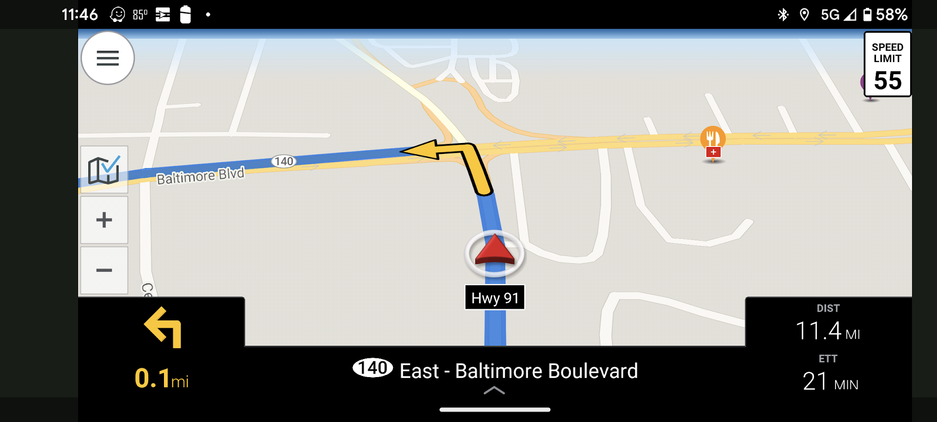
It looks like an end underway
Nice!
I hope no one gets mad for some criticism in this early stage but: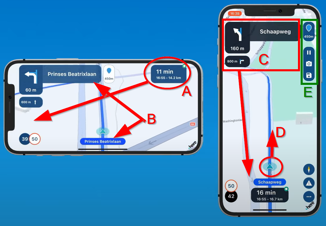
Landscape:
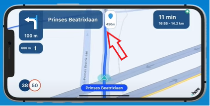
A) I think it is better to concentrate all data fields on ONE side. The center of the map (the arrow where you are) should be horizontally centered in the REMAINING part of the screen. So in this example a bit more to the right. You can already see in this example that that you can not look far enough ahead these 60 mere 60 meters to the crossing.
B) Why waste precious screenspace showing the streetname twice? I can imagine the upper name is intended for the street you are driving into, but even then it is too big and overlaps the street you are driving into
Portrait:
C) Like A, I think it is better to concentrate all datafields to ONE side of the screen, when in portrait of course the lower or upper side. Probably the lower part is best. making as much as room available as possible at the top to be able to look ahead.
D) For that maybe it is needed to up the arrow a bit, but if the street you are driving into is named on the map instead of in a very big blue area, probably not needed at all.
E) To prevent the "action icons" to overlap a right turn, these can be put as small icons horizontally at the top, maybe a bit more transparent. Where are these icons in landscape mode?
In landscape the would best be placed oposite to the datafields. So Datafields on one side of the screen, action buttons on the opposite screen, and the arrow centered in the REMAINING space.All meant as positive feedback. It looks very good sofar, also the 3D map

@Con-Hennekens said in MRA Navigation Next first video!:
It looks like an end underway
Nice!
I hope no one gets mad for some criticism in this early stage but:Landscape:
A) I think it is better to concentrate all data fields on ONE side. The center of the map (the arrow where you are) should be horizontally centered in the REMAINING part of the screen. So in this example a bit more to the right. You can already see in this example that that you can not look far enough ahead these 60 mere 60 meters to the crossing.
B) Why waste precious screenspace showing the streetname twice? I can imagine the upper name is intended for the street you are driving into, but even then it is too big and overlaps the street you are driving into
Portrait:
C) Like A, I think it is better to concentrate all datafields to ONE side of the screen, when in portrait of course the lower or upper side. Probably the lower part is best. making as much as room available as possible at the top to be able to look ahead.
D) For that maybe it is needed to up the arrow a bit, but if the street you are driving into is named on the map instead of in a very big blue area, probably not needed at all.
E) To prevent the "action icons" to overlap a right turn, these can be put as small icons horizontally at the top, maybe a bit more transparent. Where are these icons in landscape mode?
In landscape the would best be placed oposite to the datafields. So Datafields on one side of the screen, action buttons on the opposite screen, and the arrow centered in the REMAINING space.All meant as positive feedback. It looks very good sofar, also the 3D map
Regarding item A)...
Waze appears to do what is suggested...
You certainly can still see the upcoming turn displayed on the map well in advance.
Thoughts on C)... CoPilotGPS mostly displays everything on the bottom...
I'm not saying either Waze's or CoPilot's approach is the way to go. I'm just tossing examples out there as food for thought.
-
@Con-Hennekens said in MRA Navigation Next first video!:
It looks like an end underway
Nice!
I hope no one gets mad for some criticism in this early stage but:Landscape:
A) I think it is better to concentrate all data fields on ONE side. The center of the map (the arrow where you are) should be horizontally centered in the REMAINING part of the screen. So in this example a bit more to the right. You can already see in this example that that you can not look far enough ahead these 60 mere 60 meters to the crossing.
B) Why waste precious screenspace showing the streetname twice? I can imagine the upper name is intended for the street you are driving into, but even then it is too big and overlaps the street you are driving into
Portrait:
C) Like A, I think it is better to concentrate all datafields to ONE side of the screen, when in portrait of course the lower or upper side. Probably the lower part is best. making as much as room available as possible at the top to be able to look ahead.
D) For that maybe it is needed to up the arrow a bit, but if the street you are driving into is named on the map instead of in a very big blue area, probably not needed at all.
E) To prevent the "action icons" to overlap a right turn, these can be put as small icons horizontally at the top, maybe a bit more transparent. Where are these icons in landscape mode?
In landscape the would best be placed oposite to the datafields. So Datafields on one side of the screen, action buttons on the opposite screen, and the arrow centered in the REMAINING space.All meant as positive feedback. It looks very good sofar, also the 3D map
Regarding item A)...
Waze appears to do what is suggested...
You certainly can still see the upcoming turn displayed on the map well in advance.
Thoughts on C)... CoPilotGPS mostly displays everything on the bottom...
I'm not saying either Waze's or CoPilot's approach is the way to go. I'm just tossing examples out there as food for thought.
@Tim-Thompson said in MRA Navigation Next first video!:
D) For that maybe it is needed to up the arrow a bit, but if the street you are driving into is named on the map instead of in a very big blue area, probably not needed at all.
I disagree that the Bike Location Icon should be moved up.
As someone who is only ever going to use Portrait mode, I would want to see as much of the road ahead as possible, particularly when I’m on twisty country lanes, my preferred type of roads to travel on.
Being able to see the severity of the curves ahead allows for better forward planning which is always a good option to have IMO.You don’t stop riding when you get old, you get old when you stop riding.
-
@Tim-Thompson said in MRA Navigation Next first video!:
D) For that maybe it is needed to up the arrow a bit, but if the street you are driving into is named on the map instead of in a very big blue area, probably not needed at all.
I disagree that the Bike Location Icon should be moved up.
As someone who is only ever going to use Portrait mode, I would want to see as much of the road ahead as possible, particularly when I’m on twisty country lanes, my preferred type of roads to travel on.
Being able to see the severity of the curves ahead allows for better forward planning which is always a good option to have IMO.@Steve-Lynch said in MRA Navigation Next first video!:
@Tim-Thompson said in MRA Navigation Next first video!:
D) For that maybe it is needed to up the arrow a bit, but if the street you are driving into is named on the map instead of in a very big blue area, probably not needed at all.
I disagree that the Bike Location Icon should be moved up.
As someone who is only ever going to use Portrait mode, I would want to see as much of the road ahead as possible, particularly when I’m on twisty country lanes, my preferred type of roads to travel on.
Being able to see the severity of the curves ahead allows for better forward planning which is always a good option to have IMO.Just noting that the quote was misattributed to me. I was actually quoting @Con-Hennekens in that post.
I'm in total agreement with @Steve-Lynch on this point. It's conventional amongst just about every nav app that I've ever seen to have the location icon in the lower 3rd of the map. This is as it should be in my opinion.
-
@Steve-Lynch said in MRA Navigation Next first video!:
@Tim-Thompson said in MRA Navigation Next first video!:
D) For that maybe it is needed to up the arrow a bit, but if the street you are driving into is named on the map instead of in a very big blue area, probably not needed at all.
I disagree that the Bike Location Icon should be moved up.
As someone who is only ever going to use Portrait mode, I would want to see as much of the road ahead as possible, particularly when I’m on twisty country lanes, my preferred type of roads to travel on.
Being able to see the severity of the curves ahead allows for better forward planning which is always a good option to have IMO.Just noting that the quote was misattributed to me. I was actually quoting @Con-Hennekens in that post.
I'm in total agreement with @Steve-Lynch on this point. It's conventional amongst just about every nav app that I've ever seen to have the location icon in the lower 3rd of the map. This is as it should be in my opinion.
Apologies Tim.
-
@Tim-Thompson said in MRA Navigation Next first video!:
D) For that maybe it is needed to up the arrow a bit, but if the street you are driving into is named on the map instead of in a very big blue area, probably not needed at all.
I disagree that the Bike Location Icon should be moved up.
As someone who is only ever going to use Portrait mode, I would want to see as much of the road ahead as possible, particularly when I’m on twisty country lanes, my preferred type of roads to travel on.
Being able to see the severity of the curves ahead allows for better forward planning which is always a good option to have IMO.@Steve-Lynch said in MRA Navigation Next first video!:
I disagree that the Bike Location Icon should be moved up.
As someone who is only ever going to use Portrait mode, I would want to see as much of the road ahead as possible,Of course I agree with that. But moving data fields down and location icon slightly up might just achieve that. Just to prevent datafields from obscuring the map.
-
I'd like to add that more and more people are using bigger screens, some even use tablets. Dedicated Navigation devices used to be 3,5 or 4 inch, with a resolution of twice nothing. That "rule" only got broken by the most recent XT. Modern phones and rugged phones ar hard to find below 6" these days, and offer much much higher resolutions. I think the need for exorbitant large buttons, fonts and icons is much less than in the early days. They can be made a bit smaller I think, in favor of a larger map.
-
Of course everyone has their own responsibility.
But the more functions there are behind the buttons in the screen, the more riders will be inclined to use them.
'So what' am I hearing now...
But there are a lot of riders who do that while riding. And the bigger the buttons on the screen, the faster this will happen.
I often see it happen when I'm on the road with multiple riders.
Taking part in traffic is serious business.
But again everyone has their own responsibility!Oh yes. I also regularly operate my navi while riding.
@Jack-van-Tilburg said in MRA Navigation Next first video!:
Oh yes. I also regularly operate my navi while riding.
No one is more pious than the Pope
The idea of the smaller buttons for me was not to discourage people that use them in traffic. I understand your opinion, but on the other hand I am afraid that even with smaller buttons they will try and and that will attract even more attention off the road.
It would be an idea to have the buttons appear only when the speed is zero. But I think a lot of people who "can't even skip a waypoint" while riding will be mad about that. I am probably one of those people that really try to be responsible, but would not like that to be enforced.
-
For what it's worth... wouldn't it be better to wait for the first beta test? Or do you all have the idea that the design is still being tinkered with as a result of comments? I do not have the idea that MRA Navigation Next will be a copy of all other navigation apps. Of course, I hope all the best points from other apps are included, but I think that's an utopia!
🏍️ BMW K1600GT-P (2013) | Nolan N100-5 with Sena 30K
📱 iOS on iPhone 13 & 16 (mounted on Quadlock or AliExpress extention on BMW-cradle)
🚙 Apple CarPlay in VW T-Roc
💻 Routelab on MacBook Air & iMac (Tahoe & Ventura) -
For what it's worth... wouldn't it be better to wait for the first beta test? Or do you all have the idea that the design is still being tinkered with as a result of comments? I do not have the idea that MRA Navigation Next will be a copy of all other navigation apps. Of course, I hope all the best points from other apps are included, but I think that's an utopia!
@Rob-Verhoeff, MRA itself is calling out for suggestions. So we will see at least SOMETHING of them in the endproduct.
-
 undefined MyRoute-app community moved this topic from [Beta] The MyRoute-app on
Hello! It looks like you're interested in this conversation, but you don't have an account yet.
Getting fed up of having to scroll through the same posts each visit? When you register for an account, you'll always come back to exactly where you were before, and choose to be notified of new replies (either via email, or push notification). You'll also be able to save bookmarks and upvote posts to show your appreciation to other community members.
With your input, this post could be even better 💗
Register Login-
0776
-
08173
-
08187
-
07159
-
1575
-
0341.6k
-
09400
-
7221.4k