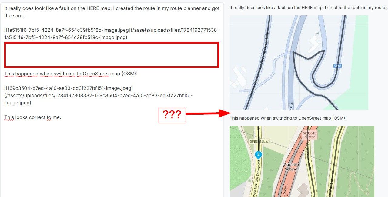
Placement of waypoints
-
@D-Griffin I don't want to come across as a high school teacher...
")
I mean it in a friendly way, but it's really a difference between operating Google maps and operating route planning tools. It would be easier for you (and for some who are going to help you) if you would become familiar with correct terms (wording).As @Con-Hennekens explained:
-
a route is a collection of (limited) routepoints, which are entered over a map during planning. The navigation tool is using the map and the roads in, to calculate the way to the next route point over that streets. And will give you instructions how to ride.
Often such points are called imprecise as "Waypoints". -
a track is a collection of trackpoints, which can also be entered over a map. Or can be recorded during ride by navigation tool (MyRoute-App calls it then Tracklog).
The navigation tool is using that points, to draw a line as overlay on the map. It does not have the need of a map to draw the line, because the points are close to each other. And therefore the navigation tool can not guide you! Exception: MyRoute-App can do it")
Routepoints can get a name (and in MyRoute-App also a description) and will presented on the map. But a Trackpoint can't get a name and will not presented on the map (only a line from one to the next trackpoint).
- third type of a point (along gpx rules) is the real Waypoint. It can be entered simply as POI; then it's only visible as point on the map. Or it will be entered additionally as Routepoint; then it is also included in the route and affects the route.
May it sounds a bit complicated, but it is not. You may plan a route, save it as gpx file on your computer. Then open this file by an Text editor; it's readable and you can find the terms:
<wpt> which is a description of a way point, means a POI, which is not a route point!
There can be a couple of such way points in the file.
<rte> which is the beginning of a description of a route with a couple (min. 2) of <rtept> which each is a route point.
<trk> which is the beginning of a description of a track with many <trkpt> which each is a track point.I tried to keep it simpl; some experts may not 100% agree. It's not necessary to understand everything in such a file. But it gives a you glimpse of the official terms and how to use it in discussions.
Nothing is impossible ;-)
In past: GARMIN Zumo 210->GARMIN Zumo 395->GARMIN XT=> now: DMD T865-X + MyRoute-App, LocusMaps, OsmAnd.
In past: GARMIN MapSource ->GARMIN BaseCamp->Tyre->Kurviger->Calimoto=> now: MRA-Routplanner. -
-
@D-Griffin I don't want to come across as a high school teacher...
I mean it in a friendly way, but it's really a difference between operating Google maps and operating route planning tools. It would be easier for you (and for some who are going to help you) if you would become familiar with correct terms (wording).As @Con-Hennekens explained:
-
a route is a collection of (limited) routepoints, which are entered over a map during planning. The navigation tool is using the map and the roads in, to calculate the way to the next route point over that streets. And will give you instructions how to ride.
Often such points are called imprecise as "Waypoints". -
a track is a collection of trackpoints, which can also be entered over a map. Or can be recorded during ride by navigation tool (MyRoute-App calls it then Tracklog).
The navigation tool is using that points, to draw a line as overlay on the map. It does not have the need of a map to draw the line, because the points are close to each other. And therefore the navigation tool can not guide you! Exception: MyRoute-App can do it
Routepoints can get a name (and in MyRoute-App also a description) and will presented on the map. But a Trackpoint can't get a name and will not presented on the map (only a line from one to the next trackpoint).
- third type of a point (along gpx rules) is the real Waypoint. It can be entered simply as POI; then it's only visible as point on the map. Or it will be entered additionally as Routepoint; then it is also included in the route and affects the route.
May it sounds a bit complicated, but it is not. You may plan a route, save it as gpx file on your computer. Then open this file by an Text editor; it's readable and you can find the terms:
<wpt> which is a description of a way point, means a POI, which is not a route point!
There can be a couple of such way points in the file.
<rte> which is the beginning of a description of a route with a couple (min. 2) of <rtept> which each is a route point.
<trk> which is the beginning of a description of a track with many <trkpt> which each is a track point.I tried to keep it simpl; some experts may not 100% agree. It's not necessary to understand everything in such a file. But it gives a you glimpse of the official terms and how to use it in discussions.
@Guzzist Thanks for the feedback. I appreciate it. I have been doing most of my mapping via waypoints and have had pretty good success. However had a few rides that went not so great. So my question on waypoints I was really looking at is to much OK? When I plan a ride I want to take the roads I want to take, like I have said since I arrived at this forum. Google doesn't allow it, but MRA does. However sometimes this thing throws me for a loop and all I'm doing is trying to get all the info I can so i can understand better. Maybe I should play with the "tracks" and see if it works better. I have watched all the online You tube videos, however a few things have changed. Not everything thats on those videos is valid in MRA anymore, or maybe they improved it.
-
-
@D-Griffin I don't want to come across as a high school teacher...
I mean it in a friendly way, but it's really a difference between operating Google maps and operating route planning tools. It would be easier for you (and for some who are going to help you) if you would become familiar with correct terms (wording).As @Con-Hennekens explained:
-
a route is a collection of (limited) routepoints, which are entered over a map during planning. The navigation tool is using the map and the roads in, to calculate the way to the next route point over that streets. And will give you instructions how to ride.
Often such points are called imprecise as "Waypoints". -
a track is a collection of trackpoints, which can also be entered over a map. Or can be recorded during ride by navigation tool (MyRoute-App calls it then Tracklog).
The navigation tool is using that points, to draw a line as overlay on the map. It does not have the need of a map to draw the line, because the points are close to each other. And therefore the navigation tool can not guide you! Exception: MyRoute-App can do it
Routepoints can get a name (and in MyRoute-App also a description) and will presented on the map. But a Trackpoint can't get a name and will not presented on the map (only a line from one to the next trackpoint).
- third type of a point (along gpx rules) is the real Waypoint. It can be entered simply as POI; then it's only visible as point on the map. Or it will be entered additionally as Routepoint; then it is also included in the route and affects the route.
May it sounds a bit complicated, but it is not. You may plan a route, save it as gpx file on your computer. Then open this file by an Text editor; it's readable and you can find the terms:
<wpt> which is a description of a way point, means a POI, which is not a route point!
There can be a couple of such way points in the file.
<rte> which is the beginning of a description of a route with a couple (min. 2) of <rtept> which each is a route point.
<trk> which is the beginning of a description of a track with many <trkpt> which each is a track point.I tried to keep it simpl; some experts may not 100% agree. It's not necessary to understand everything in such a file. But it gives a you glimpse of the official terms and how to use it in discussions.
@Guzzist I feel I paid good money for a product and just want to understand it better, thats all! The more info a person can get the better a person can be. Maybe I'm doing something wrong, maybe I don't understand how MRA fully works yet. Maybe I though it was a product that it isn't. I don't know I just appreciate the feedback. I'm all for trying ideas, because thats more time spent on my bike! However I would like to have the confidence to plot a route across the USA and feel confident I will get there...This has not always been the case. I'm not quite there yet, however am willing to put in the time to get there and fully understand....
-
-
@Guzzist I feel I paid good money for a product and just want to understand it better, thats all! The more info a person can get the better a person can be. Maybe I'm doing something wrong, maybe I don't understand how MRA fully works yet. Maybe I though it was a product that it isn't. I don't know I just appreciate the feedback. I'm all for trying ideas, because thats more time spent on my bike! However I would like to have the confidence to plot a route across the USA and feel confident I will get there...This has not always been the case. I'm not quite there yet, however am willing to put in the time to get there and fully understand....
@D-Griffin said in Placement of waypoints:
The more info a person can get the better a person can be <
Here's some more info to you. To Make you better.

I also tested for a long time to finde out, what was better, "many" or "few" waypoints.When I plan a tour that I want to do exactly as it is, I have to add one or two more points. Of course, it's also important whether I've selected a fast or short tour in the settings. I mostly use the "fast" option now.
If I have a road without major intersections, I add a point at the beginning and the end of that road. If that's the most direct route, there's no need to add additional points.
If I want to turn at an intersection, regardless whether it's a major or minor road, I add a point on the new road shortly after the turn. (If you use the "spread out" option in the toolkits, the point is often placed in the middle of the intersection. This can sometimes lead in the wrong direction.)I've actually used this approach to complete my planned tours so far and I'm fine with mit.
I'm currently planning my fourth tour through the French Alps with MRA. This time I will use Android Auto on a Carpuride W712D.Greetings Ronni
Samsung Galaxy A56 5G
Android 16
One UI Vers. 8.0
Carpuride W712D
Silverfox BT Cntroller H1+ -
Don't forget, with AA on a Carpuride you will not have all the functionality / information of the same route compared with using the native app on a phone / tablet.
I'm not saying this is better or worse, but it's something to consider.
-
@D-Griffin said in Placement of waypoints:
The more info a person can get the better a person can be <
Here's some more info to you. To Make you better.
I also tested for a long time to finde out, what was better, "many" or "few" waypoints.When I plan a tour that I want to do exactly as it is, I have to add one or two more points. Of course, it's also important whether I've selected a fast or short tour in the settings. I mostly use the "fast" option now.
If I have a road without major intersections, I add a point at the beginning and the end of that road. If that's the most direct route, there's no need to add additional points.
If I want to turn at an intersection, regardless whether it's a major or minor road, I add a point on the new road shortly after the turn. (If you use the "spread out" option in the toolkits, the point is often placed in the middle of the intersection. This can sometimes lead in the wrong direction.)I've actually used this approach to complete my planned tours so far and I'm fine with mit.
I'm currently planning my fourth tour through the French Alps with MRA. This time I will use Android Auto on a Carpuride W712D.Greetings Ronni
@Ronni Thank you for the feedback. I will try that on my next route.
-
I handle or fill the route automatically to +/- 45 WayPoints so you can go up to 50, which is not bad every 5-6 km and so you end up with +/- 300 km.
A nice day route in my opinion.
But the trick is to move your points strategically while comparing TTR and HERE at the same time but under the software behavior of TomToM.
You do through the eyes of someone who is a stranger to the subject matter.
It takes a lot of practice and it pays off afterwards. I have been working with MRA for over 10 years.( limit 50 points per route is also useful if you want to export to another device, for example the Navigator 7 from BMW which is a stubborn system but much better than version 5 and 6 !
-
@D-Griffin I don't want to come across as a high school teacher...
I mean it in a friendly way, but it's really a difference between operating Google maps and operating route planning tools. It would be easier for you (and for some who are going to help you) if you would become familiar with correct terms (wording).As @Con-Hennekens explained:
-
a route is a collection of (limited) routepoints, which are entered over a map during planning. The navigation tool is using the map and the roads in, to calculate the way to the next route point over that streets. And will give you instructions how to ride.
Often such points are called imprecise as "Waypoints". -
a track is a collection of trackpoints, which can also be entered over a map. Or can be recorded during ride by navigation tool (MyRoute-App calls it then Tracklog).
The navigation tool is using that points, to draw a line as overlay on the map. It does not have the need of a map to draw the line, because the points are close to each other. And therefore the navigation tool can not guide you! Exception: MyRoute-App can do it
Routepoints can get a name (and in MyRoute-App also a description) and will presented on the map. But a Trackpoint can't get a name and will not presented on the map (only a line from one to the next trackpoint).
- third type of a point (along gpx rules) is the real Waypoint. It can be entered simply as POI; then it's only visible as point on the map. Or it will be entered additionally as Routepoint; then it is also included in the route and affects the route.
May it sounds a bit complicated, but it is not. You may plan a route, save it as gpx file on your computer. Then open this file by an Text editor; it's readable and you can find the terms:
<wpt> which is a description of a way point, means a POI, which is not a route point!
There can be a couple of such way points in the file.
<rte> which is the beginning of a description of a route with a couple (min. 2) of <rtept> which each is a route point.
<trk> which is the beginning of a description of a track with many <trkpt> which each is a track point.I tried to keep it simpl; some experts may not 100% agree. It's not necessary to understand everything in such a file. But it gives a you glimpse of the official terms and how to use it in discussions.
@Guzzist said in Placement of waypoints:
Often such points are called imprecise as "Waypoints".
100% agree - and that's exactly what causes a lot of misunderstandings.
Many planning/navigation tools confuse the terms "route points" and "waypoints". Unfortunately, MRA is also inconsistent: while the RouteExperts documentation always refers to "route points" (which is in line with the GPX specification), the UI of the web planner and the app refer to "waypoints" when they actually mean "route points".
It would be helpful to stick closely to the GPX specification in terms of terminology; this could be implemented in MRA at some point.
-
-
A waypoint is just a location on a map. A route point is a waypoint that forms a route with other waypoints. A routepoint is just a type of waypoint.
I am just an enthusiastic MRA user, and hope you will be one too!
Most motorcycle problems are caused by the nut that connects the handlebar to the saddle.
Check out RideSleepRepeat.eu, a biker community for sharing stays across Europe
-
A waypoint is just a location on a map. A route point is a waypoint that forms a route with other waypoints. A routepoint is just a type of waypoint.
@Con-Hennekens said in Placement of waypoints:
A routepoint is just a type of waypoint.
No.
According to the GPX specification, both have the same data type (<wptType>), but one is a <wpt> and the other is a <rtept>. Same data type, different objects. -
For illustration, here is an example from my last planning session:
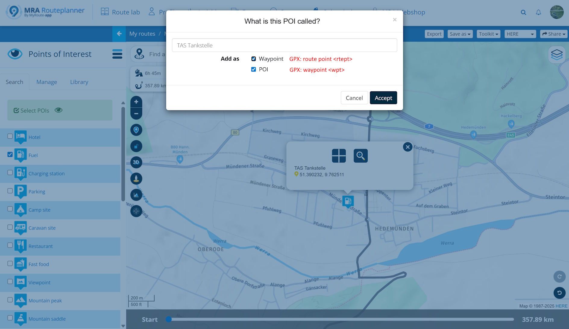
In this route, I'm about to add a fuel stop. By opening the "POI > search" tab and selecting "Fuel", a gas station symbol pops up.
I can now add this
- As a Waypoint, this will be part of my route
- As a POI, this will not be part of my route but a separate spot/point
When saving as GPX, 1. becomes a route point <rtept> while 2. becomes a waypoint <wpt>
-
For illustration, here is an example from my last planning session:
In this route, I'm about to add a fuel stop. By opening the "POI > search" tab and selecting "Fuel", a gas station symbol pops up.
I can now add this
- As a Waypoint, this will be part of my route
- As a POI, this will not be part of my route but a separate spot/point
When saving as GPX, 1. becomes a route point <rtept> while 2. becomes a waypoint <wpt>
@Martin-Wilcke that's incorrect. Option 2 will just add a visible point on the map and had no effect what so ever on the route. The RouteXperts add those POI's in every viapoint in the route. That viapoint is something important in the route like a castle, museum gasstation etc
Honda Goldwing GL1500,
Honda Silverwing GL 650
DMD2 T865X 8 inch Android tablet using MRA next for navigation
Garmin XT sold
Samsung S24FE mounted on a Quadlock and using Android Auto in my car -
@Martin-Wilcke that's incorrect. Option 2 will just add a visible point on the map and had no effect what so ever on the route. The RouteXperts add those POI's in every viapoint in the route. That viapoint is something important in the route like a castle, museum gasstation etc
@Marinus-van-Deudekom said in Placement of waypoints:
that's incorrect. Option 2 will just add a visible point on the map and had no effect what so ever on the route.
That's what I said: 2. is not part of the route. What exactly is incorrect?
-
@Marinus-van-Deudekom said in Placement of waypoints:
that's incorrect. Option 2 will just add a visible point on the map and had no effect what so ever on the route.
That's what I said: 2. is not part of the route. What exactly is incorrect?
@Martin-Wilcke indeed Martin, misread your post

-
@Con-Hennekens said in Placement of waypoints:
A routepoint is just a type of waypoint.
No.
According to the GPX specification, both have the same data type (<wptType>), but one is a <wpt> and the other is a <rtept>. Same data type, different objects.@Martin-Wilcke said in Placement of waypoints:
No.
According to the GPX specification, both have the same data type (<wptType>), but one is a <wpt> and the other is a <rtept>. Same data type, different objects.Yes.
Both have the same datatype because they are both waypoints...
And of course they have different node names, because the need to be treated differently.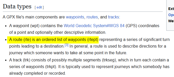
I am just an enthusiastic MRA user, and hope you will be one too!
Most motorcycle problems are caused by the nut that connects the handlebar to the saddle.
Check out RideSleepRepeat.eu, a biker community for sharing stays across Europe
-
@Martin-Wilcke said in Placement of waypoints:
No.
According to the GPX specification, both have the same data type (<wptType>), but one is a <wpt> and the other is a <rtept>. Same data type, different objects.Yes.
Both have the same datatype because they are both waypoints...
And of course they have different node names, because the need to be treated differently.@Con-Hennekens
I'm aware of this description, and it's likely the root cause of all this confusion because it mixes up elements and types.This becomes clear when you take a look at the schemas:
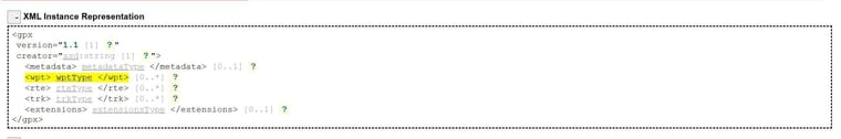
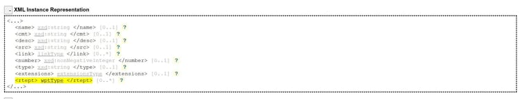
<wpt> is an element, <rtept> is a different element. Both have the same type (<wptType>).
-
@Martin-Wilcke said in Placement of waypoints:
No.
According to the GPX specification, both have the same data type (<wptType>), but one is a <wpt> and the other is a <rtept>. Same data type, different objects.Yes.
Both have the same datatype because they are both waypoints...
And of course they have different node names, because the need to be treated differently.A Trackpoint (<trkpt>) has the same type <wptType>, but you wouldn't call a track point a waypoint, right?

-
A Trackpoint (<trkpt>) has the same type <wptType>, but you wouldn't call a track point a waypoint, right?
@Martin-Wilcke, I am sorry Martin, but how things get a designation in XML code has little to do with how things are called in human language. I am discontinuing this meaningless discussion now.
I am just an enthusiastic MRA user, and hope you will be one too!
Most motorcycle problems are caused by the nut that connects the handlebar to the saddle.
Check out RideSleepRepeat.eu, a biker community for sharing stays across Europe
-
@Martin-Wilcke, I am sorry Martin, but how things get a designation in XML code has little to do with how things are called in human language. I am discontinuing this meaningless discussion now.
It's not meaningless, but I agree: we should stop this discussion because it's probably not of interest to most users here.
As long as planning and navigation are entirely done with MRA, there is no need to know anything about GPX details. If, however, GPX data are spread around different apps and devices, it's at least good to know that there are other interpretations of waypoints and route points. Just to be aware and not get trapped
-
It's not meaningless, but I agree: we should stop this discussion because it's probably not of interest to most users here.
As long as planning and navigation are entirely done with MRA, there is no need to know anything about GPX details. If, however, GPX data are spread around different apps and devices, it's at least good to know that there are other interpretations of waypoints and route points. Just to be aware and not get trapped
@Martin-Wilcke, With that I can only agree
Hello! It looks like you're interested in this conversation, but you don't have an account yet.
Getting fed up of having to scroll through the same posts each visit? When you register for an account, you'll always come back to exactly where you were before, and choose to be notified of new replies (either via email, or push notification). You'll also be able to save bookmarks and upvote posts to show your appreciation to other community members.
With your input, this post could be even better 💗
Register Login-
0431.1k
-
016317
-
0564
-
04126
-
010304
-
0323
-
06212
-
0287.8k