New update! (4.3.0) Project sync
-
@Peter-Schiefer
Agreed.
But to clarify: I'm not comparing the web planner with the app planner. It's about the different map layer sets within the app.
Several map layers are available in "browse/view" mode, including OSM, HERE and TomTom.
In "edit/planning" mode ("MRA Routeplanner"), however, we have one map layer (HERE) with various style options: Vulf, Wong, Dart and a bunch of "edition" options (explore, topo, satellite, etc.)
I'd like to know if this will be harmonised and, if so, in which way.@Martin-Wilcke : My experience with this is, plan no matter with which map and at the very end HERE takes over when routing.
With too few route points, it is not the app that is surprised but the driver.
HERE is the machine base the rest is for better overview.
That's how I understood it.
It was noticed:
-
HERE in the web planner
-
HERE in the app
Somehow don't seem to be the same as that was just my impression, but can also be due to the now very many setting options ....
VG
VG Hubert
Beta Test "Next App" dazu die Hardware .
iPad 9. Gen iOS 26.5.2/ iPhone 16e iOS 26.5.2/ Navi iPhone Xr iOS 18.7.9 / PC mit MS Win11 /❗️MyRoute-App im Cradel und Remotek-One❗️ Info zu MRA & Remotek One -
-
Waar dient dan nu de download map nog voor dan als we voortaan sync'n
-
Waar dient dan nu de download map nog voor dan als we voortaan sync'n
@marc-van-der-heijden voor routes of tracks die NIET gesynchroniseerd kunnen worden, te weten: routes van/uit:
- vrienden
- evenementen
- groepen
Deze routes zal je altijd óf moeten overhalen naar je eigen account zodat ze wél gesynchroniseerd kunnen worden óf offline beschikbaar moeten maken. In beide gevallen is dit dus geenszins gesynchroniseerd en altijd handmatige actie. Je hebt dan dus ook nooit automatisch de laatste stand van de route indien de eigenaar van die route wijzigingen aanbrengt... Dit brengt dus ook meteen inzichtelijk hoe waanzin waardevol die sync functie dus eigenlijk wel niet is!
-
@Peter-Schiefer
Agreed.
But to clarify: I'm not comparing the web planner with the app planner. It's about the different map layer sets within the app.
Several map layers are available in "browse/view" mode, including OSM, HERE and TomTom.
In "edit/planning" mode ("MRA Routeplanner"), however, we have one map layer (HERE) with various style options: Vulf, Wong, Dart and a bunch of "edition" options (explore, topo, satellite, etc.)
I'd like to know if this will be harmonised and, if so, in which way.@Martin-Wilcke said in New update! (4.3.0) Project sync:
Several map layers are available in "browse/view" mode, including OSM, HERE and TomTom.
In "edit/planning" mode ("MRA Routeplanner"), however, we have one map layer (HERE) with various style options: Vulf, Wong, Dart and a bunch of "edition" options (explore, topo, satellite, etc.)
I'd like to know if this will be harmonised and, if so, in which way.Works is being done on a new completely new and enhanced webplanner. Currently the app-planner and the web-planner are written on different development platforms with different features. I think it would be logical that the new web-planner will be written on the same platform as the app, but I really don't know that. Complicating factor in that is that due to licensing restrictions not everything can be shared cross platform. Hence the TomTom and OSM maps are not available in the app-planner. Future will tell, but there certainly is no wish to keep thing separate
")
-
@Martin-Wilcke : My experience with this is, plan no matter with which map and at the very end HERE takes over when routing.
With too few route points, it is not the app that is surprised but the driver.
HERE is the machine base the rest is for better overview.
That's how I understood it.
It was noticed:
-
HERE in the web planner
-
HERE in the app
Somehow don't seem to be the same as that was just my impression, but can also be due to the now very many setting options ....
VG
@Hubert-Thoring
Hubert,
That sounds like a good strategy - but it is out of the scope of my question. Sorry for the confusion; I will try to clear it up.The latest upgrade introduced a beautiful new map layer to the app. It is based on HERE, can be configured with three different "colour schemes" (Vulf, Wong, Dart) and six "editions" (Explore, Simplistic, Topo, etc.) and looks like this:
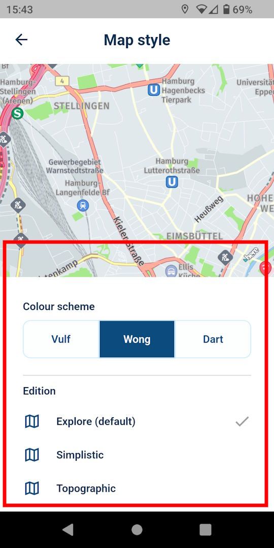
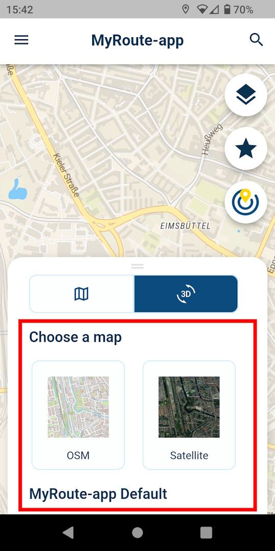
This new map layer, however, is available only for planning/editing routes with the "MRA Routeplanner".When opening a route for viewing/browsing, on the other hand, we still have the traditional maps where I can pick one out of twelve (MyRoute-app Default, MyRoute-app Street, MyRoute-App Outdoor, HERE, TomTom). Looks like this:
So, we have entirely different maps within the myRoute-app for various purposes. That is quite unusual; all other planning apps I know of use identical map(s) throughout the app.
My question is: Will the "traditional" and "new" maps be harmonised within the myRoute app, or are different maps for separate tasks part of a design concept?
(And to cover this as well: Yes, we still have one HERE "map" in terms of a "routing engine" that is responsible for calculating a route - but this is a different story.)
-
-
@Peter-Schiefer, please try to avoid quoting complete messages. Especially if they contain such large pictures. It is perfectly fine to quote lines you are responding to, but to quote complete messages is not necessary.
-
@Peter-Schiefer said in New update! (4.3.0) Project sync:
Martin with this comment
This new map layer, however, is available only for planning/editing routes with the "MRA Routeplanner".
you are wrong.nope.
Maybe you haven't discovered the MRA Routeplanner so far? Open the myRoute-app and then press this button:
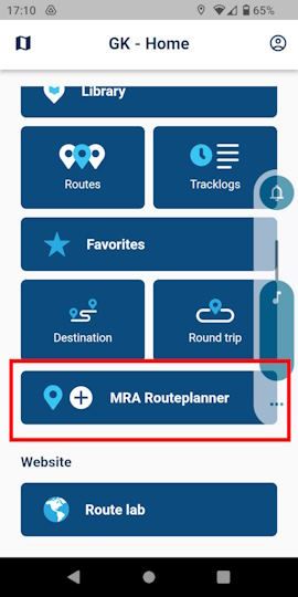
There you have the new maps for planning a route. -
Hi all!

This week, we got a lovely update for MyRoute-app coming your way

A massive shoutout to Joost is well deserved
") He works in the dark to serve the light! And he definitely brings to light to all MRA users with this update. After a lot of technical coding
He works in the dark to serve the light! And he definitely brings to light to all MRA users with this update. After a lot of technical coding  we are proud to present this smashing 4.3.0 update: project Sync!
Sync all your routes
Sync? What is sync? According to the oxford dictionary:
in (or out of) sync working well (or badly) together; in (or out of) agreement.
With this update, the app will sync well with the website.
Meaning that all your routes will be magically synced across both platforms

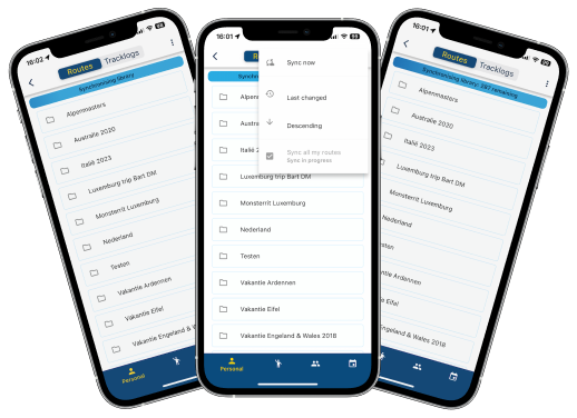
You can sync all your routes or choose an individual route to be synced.
When a route (or all for that matter) is marked as syncable, any changes made to that route in the app, will be uploaded to the website. Or when the route is modified on the website, it will be automatically updated on your phone
By doing so, all your routes will be available in the app all the time and most important of all, they are up to date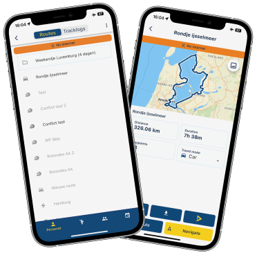
Therefore the downloads folder now no longer contains your own routes.
You also can't download your own routes as you were used to. Just sync them and you are ready to go!
Groups / events / friends are not synced or available offline by default. You will still need to download these yourself and yes, they can be found in your downloads.Conflict handling
What if you made changes in the app and on the website? How do we select the right one to save? We don't! You do
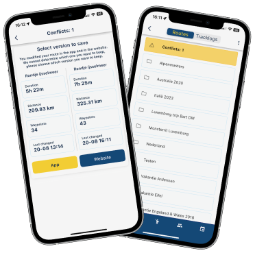
Conflicts are automatically detected and you are forced to resolve these in the app.
Restyling information screen
To facilitate the offline availability of all your routes, the information screen has been modified too!
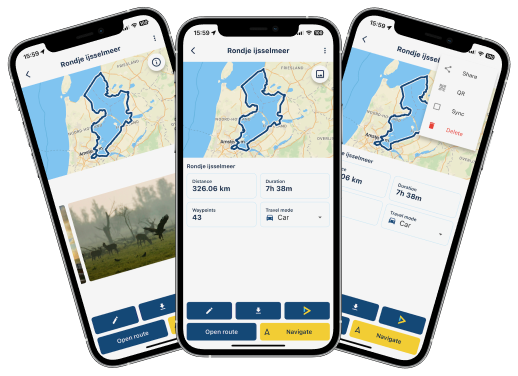
A cleaner look and besides that the following options have been added:
- Share link to route
- Show QR code for easy access
- Mark route to be synced
- Delete
Map styles navigation
This one will make a lot of people very, very happy!
The HERE map lacked some detail. Sad but true

A weird development how all major map suppliers changed their colour scheme to be less rich in contrast.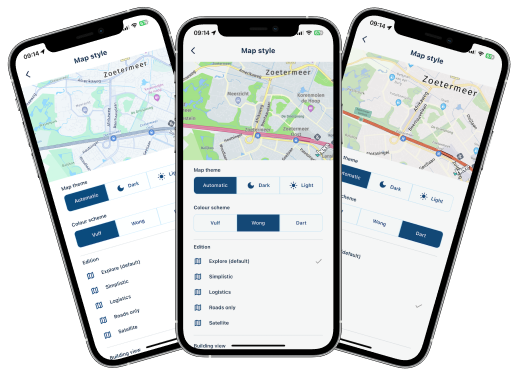
Head over to the map styling section and be amazed! We offer 3 different colour themes and 6 editions! Are you oriented on logistical roads, we got your back!
Want to use the old colour scheme? Try out "Wong" Map configuration
We all enjoy styling / customising the map. More settings have been added!
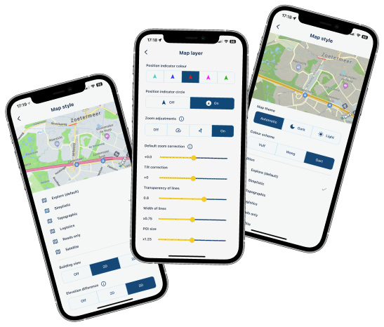
- Allow showing elevation differences in map (only for explore & topographic)
- Change width / opacity of the displayed lines
- Change scaling of POI icons shown on the map
- Larger range of allowed zoom / tilt adjustments
Elevation difference? Is that noticeable?
Oh hell yeah!
(old / 3d / 2d). I mean, just look at it 
Improvements generated routes
Did you ever generate a nice route? Did you ever want to save / share that? I guess both apply to you but you could never achieve the second

An issue that is no more!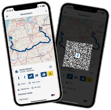
Generate a route and with the touch of a button, you can share the same configuration to your buddy. As this is a QR code, we expect the person that scans it, to be in the same location as you
If not, just save the route! Then you can share the route and it will work too.Minor changes
- Improved Spanish translations thanks to active MRA user Ramon C.L.

- GPX files can be uploaded to MRA simply by opening them with the app
- You can now switch between imperial and metric directly from the app
- Fixed issue where some users could not use the search
- Fixed issue that caused people from Luxemburg to not be able to save their tracklog
- General textual improvements
- Added information popups to complicated settings
- HERE SDK updated to newest version
Wrapup
If this isn't a great update, I don't know what else we can do!
Hopefully you all enjoy this update. After this update we will do another iteration concerning the app stability. Minor new features will also be added such as automatically starting your route at the nearest marker or locking your screenCheers,
Corjan@Corjan-Meijerink said in New update! (4.3.0) Project sync:
automatically starting your route at the nearest marker
Excellent work again MRA team! Looking forward forward to automatically starting the route at the nearest marker. I'm guessing you can still select to start at the 1st marker.
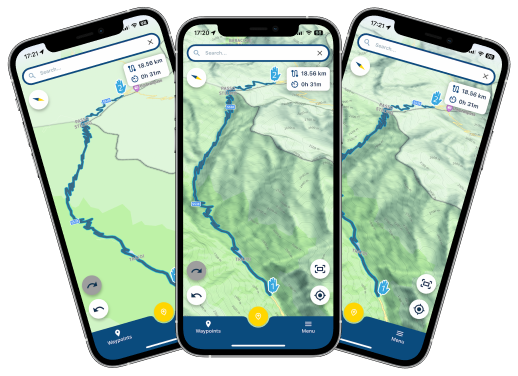
Love new map colours and options with the additional zoom and tilt
 . Having bigger speed camera icons is great!
Maps sync and not having to pre-download maps from when navigating offline is genius!!
Well done team, keep on improving. Any news on battery drain?

 .
. -
@Corjan-Meijerink said in New update! (4.3.0) Project sync:
automatically starting your route at the nearest marker
Excellent work again MRA team! Looking forward forward to automatically starting the route at the nearest marker. I'm guessing you can still select to start at the 1st marker.
Love new map colours and options with the additional zoom and tilt
. Having bigger speed camera icons is great!Maps sync and not having to pre-download maps from when navigating offline is genius!!
Well done team, keep on improving. Any news on battery drain?
.@JP-d said in New update! (4.3.0) Project sync:
I'm guessing you can still select to start at the 1st marker.
In that case just turn the switch for this function to off. Default always rp1 is used, unless you deliberately set the switch to on.
-
nice function project sync but i get a error that my local database is full. is it not an option to select maps for sync ? i have a few maps with routes i have taken from groups or other media and i only did save then for later use. this is on ios and normal version. just looked at my android with beta and there no error that local database is full.
@Bouke-Ent 4.3.1 is the new beta with increased memory limit. The issue will be resolved on your iOS when the new version is released next week (4.3.1).
-
@Bouke-Ent 4.3.1 is the new beta with increased memory limit. The issue will be resolved on your iOS when the new version is released next week (4.3.1).
@Corjan-Meijerink said in New update! (4.3.0) Project sync:
@Bouke-Ent 4.3.1 is the new beta with increased memory limit. The issue will be resolved on your iOS when the new version is released next week (4.3.1).
now i did solve it by cleaning up MRA and remove MRA Next ios app and reinstall. now sync without error. but still i think it would be not a bad idea to sync by forder/map. not all in need on the way. i normaly only use my vacation or my moto group folders/maps. mostly rest is done or still in planning/idea mode.
-
@Corjan-Meijerink said in New update! (4.3.0) Project sync:
@Bouke-Ent 4.3.1 is the new beta with increased memory limit. The issue will be resolved on your iOS when the new version is released next week (4.3.1).
now i did solve it by cleaning up MRA and remove MRA Next ios app and reinstall. now sync without error. but still i think it would be not a bad idea to sync by forder/map. not all in need on the way. i normaly only use my vacation or my moto group folders/maps. mostly rest is done or still in planning/idea mode.
@Bouke-Ent
I am with you, some users have houndrets of route in several files and need only a few for the next vacation, week, whatever.But it is as it is, some prefer this, some not and MRA trust in their way, which is sometimes a bit different to usual common practices in computer based handling. So what, the advantages of MRA predominate up to now, even with some frustration coming up and unexpected reactions.
Yeterday I am back home and made my standard test and I had a lot of problems with verbal announcements of the POIs with 335. Informations are announced by random. No preannouncement but confirmation. preannouncement of POI1 but confirmation „You reached no 1“ when I reached the Sp 2, nothing was called for WP 5.
An i folow the roules for announcemts and before 4.3. it works on the same route.
I am meanwhile also frustrated to write about this and stop here.Regard to your concern
My solution for easy access to my routes I want to use next session I create a folder „AA routes for use“ which is by alphabetic order the first file on the screen. Those routes I need will be copied in this folder with the same name and the appendix -copy- they get automatically.
The originals stays in their folder and when the session is over it is easy to delete only the copies. -
 undefined Bouke Ent referenced this topic on
Hello! It looks like you're interested in this conversation, but you don't have an account yet.
Getting fed up of having to scroll through the same posts each visit? When you register for an account, you'll always come back to exactly where you were before, and choose to be notified of new replies (either via email, or push notification). You'll also be able to save bookmarks and upvote posts to show your appreciation to other community members.
With your input, this post could be even better 💗
Register Login-
71034.8k
-
0480
-
744597
-
1643
-
09284
-
04234
-
011144
-
06192
