Planning Vs Navigation (OpenStreetMap Vs Here)
-
I think I’m getting confused, or missing a step, but it feels like I have to almost double plan and double check the route when move it from planning to navigating. Let me explain….
- Using myRouteApp website, I plan a new route using the default OpenStreetMap map. This map contains detailed data and POI, and so I carefully plan the route (shaping points) and stops (waypoints).
- Once I have the route completed, I then switch to the myRouteApp on iOS, and select the route I created on the web.
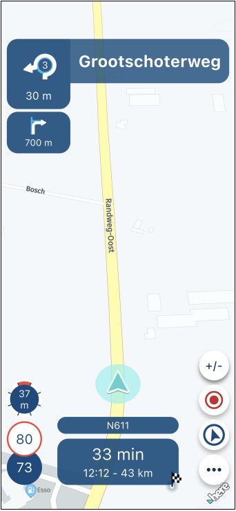
- I click to Navigate, and it warns me that the route was created using OpenSteetMap and may not transfer accurately to Here maps for navigating. And indeed, when I look closely at the navigation route, it is slightly, but definitely different to the planned route.
So then after step 1 above, I switch the web app to use Here map, and again the route has changed, so then I have to meticulously go through the route again in Here maps to make corrections - doubling the work.
Alternatively I could plan the route directly using Here map, but that overlay has very poor details, no/limited POIs, and actually not a good map at all for planning.
So Is my flow incorrect? What is the best approach? Is there something I’m missing when planning or navigating?
-
I think I’m getting confused, or missing a step, but it feels like I have to almost double plan and double check the route when move it from planning to navigating. Let me explain….
- Using myRouteApp website, I plan a new route using the default OpenStreetMap map. This map contains detailed data and POI, and so I carefully plan the route (shaping points) and stops (waypoints).
- Once I have the route completed, I then switch to the myRouteApp on iOS, and select the route I created on the web.
- I click to Navigate, and it warns me that the route was created using OpenSteetMap and may not transfer accurately to Here maps for navigating. And indeed, when I look closely at the navigation route, it is slightly, but definitely different to the planned route.
So then after step 1 above, I switch the web app to use Here map, and again the route has changed, so then I have to meticulously go through the route again in Here maps to make corrections - doubling the work.
Alternatively I could plan the route directly using Here map, but that overlay has very poor details, no/limited POIs, and actually not a good map at all for planning.
So Is my flow incorrect? What is the best approach? Is there something I’m missing when planning or navigating?
@Raj-2 Plan your route using the HERE planning map, use any of the overlay maps for information. Overlay maps are just that - an overlay.
-
I think I’m getting confused, or missing a step, but it feels like I have to almost double plan and double check the route when move it from planning to navigating. Let me explain….
- Using myRouteApp website, I plan a new route using the default OpenStreetMap map. This map contains detailed data and POI, and so I carefully plan the route (shaping points) and stops (waypoints).
- Once I have the route completed, I then switch to the myRouteApp on iOS, and select the route I created on the web.
- I click to Navigate, and it warns me that the route was created using OpenSteetMap and may not transfer accurately to Here maps for navigating. And indeed, when I look closely at the navigation route, it is slightly, but definitely different to the planned route.
So then after step 1 above, I switch the web app to use Here map, and again the route has changed, so then I have to meticulously go through the route again in Here maps to make corrections - doubling the work.
Alternatively I could plan the route directly using Here map, but that overlay has very poor details, no/limited POIs, and actually not a good map at all for planning.
So Is my flow incorrect? What is the best approach? Is there something I’m missing when planning or navigating?
@Raj-2 When I am planning a route, I cycle through more than one overlay to optimize my route. Most of the time I use Michelin and look up details with Streetview. With this help I place Waypoints and shaping points. When I am all done I look closely in HERE if points are placed off-road. I Correct them and, in my case, I send it to my Garmin.
Met andere apps maak je een route, met MRA componeer je een route!
Ducati Monster 1200 met Garmin Zümo XT
Fiat 124 Spider/Camper Dethleffs met Navigation-App op Samsung Tab Active4 Pro
MRA Lifetime Gold -
@Raj-2 When I am planning a route, I cycle through more than one overlay to optimize my route. Most of the time I use Michelin and look up details with Streetview. With this help I place Waypoints and shaping points. When I am all done I look closely in HERE if points are placed off-road. I Correct them and, in my case, I send it to my Garmin.
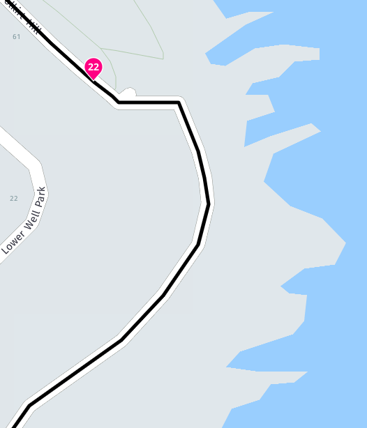
@Lex-Kloet When you use an overlay map the track line that you see is created by the planning map so there is no need to look closely in the HERE map as the track line is created by HERE if that is the planning map that is used.
My first example shows the OSM overlay on a HERE planning map. You can see the difference in the position of the road. My second example is from the HERE overlay.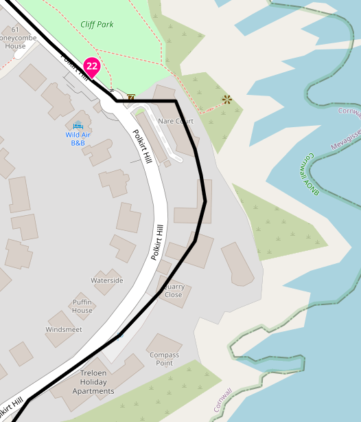
-
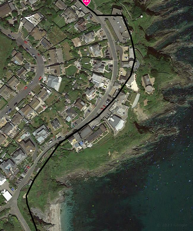
This satellite view of the same road above shows that there can often be some inaccuracies in the mapping and it is why we advise people to not place route points too close to roundabouts, viaducts and junctions.
Always willing to help if I can.
Triumph Tiger 1200 XRT called Tina.
MRA Navigation Next and SilverFox BJ8 -
This satellite view of the same road above shows that there can often be some inaccuracies in the mapping and it is why we advise people to not place route points too close to roundabouts, viaducts and junctions.
@Nick-Carthew I know what you mean. But what I meant is I "draw" the tour roughly in the overlays, without caring about the positioning in the HERE map. That is the finetuning that I do afterwards.
Hello! It looks like you're interested in this conversation, but you don't have an account yet.
Getting fed up of having to scroll through the same posts each visit? When you register for an account, you'll always come back to exactly where you were before, and choose to be notified of new replies (either via email, or push notification). You'll also be able to save bookmarks and upvote posts to show your appreciation to other community members.
With your input, this post could be even better 💗
Register Login-
0393
-
0258
-
0397
-
0112
-
12205.1k
-
315519
-
0351.8k
-
017441