Skip to content

Routes & Tracks

412 Topics 2.6k Posts

Here you can share your favorite routes & tracks for others to use

  • Riding a track on Zumo XT

    3
    0 Votes
    3 Posts
    2k Views
    Steve Lynch
    @Alain-a On the XT and in the XT manual they no longer use the word “Journey” at all. If you use the export option .GPX 1.1 (Beta, Route, Track, POI) in conjunction with the Garmin Drive App it will automatically create a route in the Trip Planner App on the XT with full directions visible and audible. It will also give you the track in Explore on the XT. Often people will advise that you make the Track visible on the map so that if there are any road closures you can visually follow the Track to get you back onto the route. (I am now going to use this as you will see mentioned further below) However as far as I can see this requires that you place the track in a collection but again as far as I know there is no way to create a Collection directly on the XT. You have to use the Explore Website (Not the Explore App) and you must have the Garmin Drive App open as well for the Collection to transfer to the XT. You can then add the Track to this Collection and display the Track on the Map. It all seems very clunky and convoluted of Garmin to have us jumping through hoops like this just to get a Collection onto the XT so if anyone knows a way to directly add a Collection on the XT please do let us know. My personal preference is to place at least 1 shaping point (I never use Via Points) on every single road that I wish to travel on. This ensures that my route stays exactly as I want it without Garmin deciding “Hey go this way it can save you 15 Minutes”. In the first couple of months of doing this it was flawless in getting me back to the route if I came across a road closure, but recently, for whatever reason it has occasionally instigated some “Make a U-Turn” prompts. I am still trying to work out how to reliably skip x amount of Shaping points on the XT. To resolve these issues in the mean time, I just zoom the map out and visually find a way back to the route by memory. I think I will start adding the Track to a collection for all my routes until I work out how to avoid these strange and sometimes unecassary U-Turn prompts. Tracks do have another purpose though for Off Roading on UK Green Lanes. Particularly if you are in an area were there are lots of BOATS (Byways Open to All Traffic) but also Bridleways that vehicles cannot go on. (I have accidentally gone on a Bridalway a couple of times ) Here’s an example of Salisbury Plains on the XT with only the BOAT’s visible in a Single Collection of 70+ green lanes. You don’t get any prompts at all you just visually follow the tracks. [image: Salisbury Plain.jpg]
  • Tussenpunt bij rondrit

    2
    0 Votes
    2 Posts
    711 Views
    Nick Carthew
    @Ruud-van-den-Langenberg Yes. [image: AAAC0F78-932B-4E20-98B4-FDEB98C92F31.jpeg]
  • POI in Tom Tom

    7
    0 Votes
    7 Posts
    3k Views
    HABVEN aka MrMRA
    @Vliegen-Eric De POI’s opslaan als mijn plaatsen of favorieten in je TomTom. Even googelen op POI’s opslaan op TomTom
  • Exportieren einer Route auf Garmin Zumo 550

    41
    1
    0 Votes
    41 Posts
    21k Views
    hammes
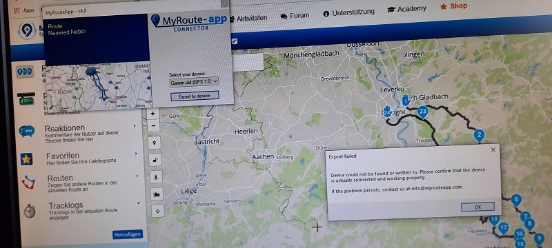
    Erstmal Danke an alle. Habe fast alle Vorschläge ausprobiert, will nicht. Kann im Moment nicht weiter forschen, da Navi defekt. Sollte ich es irgendwie schaffen, werde ich Bescheid sagen.
  • Thuringer Wald

    5
    0 Votes
    5 Posts
    1k Views
    Rene van Ooijen
    Ah, OK. Ik heb deze routes nu dan openbaar gemaakt en gepubliceerd.
  • Change Route in Track

    5
    0 Votes
    5 Posts
    2k Views
    Luis Oliveira
    Thank you very much
  • How can I add a coffee stop in my route?

    4
    0 Votes
    4 Posts
    1k Views
    PAD 0
    Regardless of the program/app used, I avoid adding POIs to my routes as, over the years, I have found they can provide unreliable data. Petrol stations no longer in existence, cafés closed down, etc. I do use POIs in the planning stage, but only as an indicator of what might exist in an area. Based on them, I double check using other sources, such as Google Maps & Street View (always checking the date of the Street View imaging because it can vary widely) and following website links to a venue, etc. Once I’m satisfied that a venue or location checks out, I add it as a waypoint, label it appropriately and set it as a via point, rather than a shaping point. That might seem a bit OTT to some? But I plan a number of tours, group and long rides each year and I have found that this approach can save a lot of hassle on the road.

  • Achteraf je vertrektijd toevoegen

    3
    0 Votes
    3 Posts
    966 Views
    AndreBC
    top gevonden. Zat steeds te zoeken in de route zelf en niet in het overzicht.
  • Wie weet voor mij het antwoord mbt kaarten

    4
    0 Votes
    4 Posts
    1k Views
    Drabslab
    @StefanHummelink aha, dat zou misschien wel voldoende duidelijk moeten geweest zijn Aangezien Keulen niet in de benelux ligt (denk ik ) zal ze de kaart van europa moeten selecteren vermoed ik. De vraag is natuurlijk voor welke kaart ze betaald heeft bij "tommie" en welek kaart op haar GPS opgeladen zijn
  • Exporting to a BMW car

    2
    0 Votes
    2 Posts
    755 Views
    Nick Carthew
    @Pierre-c Not restricted to 20 as far as I am aware.
  • MRA to BMW Nav V1 Track

    3
    0 Votes
    3 Posts
    845 Views
    Nick Carthew
    @Martin-Proudlove Use the search feature in this forum. There have been many topics relating to BMW Nav vi. Just type in BMW Nav vi into the search box.
  • Scotland

    Moved
    4
    0 Votes
    4 Posts
    2k Views
    PAD 0
    A great suggestion from @Wallace-Shackleton regarding the A710/711 - that’s a relatively little known and very beautiful stretch of coastline. In fact, the whole area is a bit special - not with the typical grandeur of the Highlands, but rolling, soft, gentle... After that, I suggest moving away from the coast, heading from Kirkudbright to New Galloway on the A762 then the A712 to Newton Stewart and the A714 to Girvan from there. From Girvan, the B741 is entertaining as far as Dalmellington. In terms of getting to Edinburgh from there, beyond Dalmellington is ‘here be dragons’ territory for me, but the A70 has to be a candidate?
  • Vakantieroute opbouwen mbv interessante bestemmingen

    2
    0 Votes
    2 Posts
    667 Views
    Nick Carthew
    @Ina-Veldhuizen Ja, u kunt POI's toevoegen als visuele indicator.
  • Saving of MyDrive Login data!

    2
    0 Votes
    2 Posts
    857 Views
    Nick Carthew
    @Michael-16 I have a password manager that handles my logins.
  • Public routes not in library

    19
    1
    0 Votes
    19 Posts
    5k Views
    Rene van Ooijen
    @Hans-van-de-Ven-MRA-Master Dan moest het toch ergens aan mijzelf/mijn browsers liggen. Heb vanmorgen in alle 3 de browsers de cache eens opgeschoond. Daarna afgesloten en opnieuw opgestart. Link in URL balk geplaatst en zie daar ...... alles nu in KM. Bedankt voor alle moeite die jullie hebben gedaan.
  • Transfer gpx route files from Android phone to Zumo XT using GarminDriveApp

    2
    0 Votes
    2 Posts
    1k Views
    HABVEN aka MrMRA
    Thanks @An9dy
  • MRA Route to BMW Nav6

    13
    0 Votes
    13 Posts
    5k Views
    TorqueRider
    @Sheldon-Barnes Could it be that you accidentally use the original route instead of the converted track? Did you go through the correct steps to convert the track? If you export a route from MRA as GPX 1.1 BMW, the NAV will receive a route and a track. You do not use this route. So do not import if the device asks for it. Go to the track on your nav and specify "Show on Map" in the properties. Then you can adjust the display color to your liking at "Set Color". Then "Convert to Trip"
  • Road - offroad route plannen

    4
    0 Votes
    4 Posts
    1k Views
    HABVEN aka MrMRA
    @Georgette-Traa Ja, rechte lijnen, dan op zicht rijden op de track in je navigatie systeem
  • Garmins bad update and the new Zumo XT

    8
    0 Votes
    8 Posts
    3k Views
    Steve Lynch
    My preference for the XT, after much testing like yourself, is to use the Beta export but I only ever use shaping points and I use the Trip Planner exclusively. I actually put at least 1 shaping point on every road on the route. Yes it means extra work creating the route but for those times when I do go off route there are less chances for dodgy recalculations. I did use the Track Visible option for a while but I have found it pointless due to the amount of shaping points I add. For me Garmin Tracks have only one purpose. UK Green Lanes (Byways Open to All Traffic). I plot them on the OS Maps Software and Transfer directly to the XT. No more accidentally going down a Bridleway and enduring the wrath of the Walkers and Horse Riders.
  • Fuel Stops

    7
    1 Votes
    7 Posts
    2k Views
    Nick Carthew
    @Sheldon-Barnes said in Fuel Stops: Hi Nick, Thats pretty much what ive been doing, but thought there may be a feature i didnt know about Im setting off doing the NC500 on 18th including a few thigs to visit on the way up and down, taking in roads i think will provide the best scenery. My bike does around 230miles per tank, so to be safe was thinking of every 200 miles There are ample fuel stops on the NC500 I have some highlighted on my RouteXpert route click the link NC 500 RouteXpert
ACTIVE USERS POPULAR TOPICS MY GROUPS