How many softpoints and hardpoints do you use?
-
I'm curios how others think of their route design. Specifically when I begin a new route I have a LOT of Shaping points, and just a few Waypoints. After I do my comparisons with Tom tom and Open Street map in both Fastest and shortest modes, I begin talking out shaping points that doing so doesn't alter the route. If it does I either move it or keep it.
You can end up with very few shaping points on segments of the trip.
How do others use their shaping points/waypoints? How many do you typically use for say 200Mile/322k trip?
Do you have a method to your madness? Meaning why do you do it that way.
"There is no problem so bad that you can't make it worse"
- Chris Hadfield (NASA Astronaut)
-
I'm curios how others think of their route design. Specifically when I begin a new route I have a LOT of Shaping points, and just a few Waypoints. After I do my comparisons with Tom tom and Open Street map in both Fastest and shortest modes, I begin talking out shaping points that doing so doesn't alter the route. If it does I either move it or keep it.
You can end up with very few shaping points on segments of the trip.
How do others use their shaping points/waypoints? How many do you typically use for say 200Mile/322k trip?
Do you have a method to your madness? Meaning why do you do it that way.
@Greenham It depends on how many twists turns and junctions are on the route and if you are using a Garmin Zumo XT waypoints/shaping points to stop it using main roads when you have it set to "Faster Time". For a route of 200 miles I'd tend to have around 30-50 waypoints with most of these being shaping points in Garmin speak and some Via points for places I want to stop. But it depends Ireland has many small roads that I like to navigate on. The North of Scotland does not have many options for roads so the number of waypoints would be less.
-
I'm curios how others think of their route design. Specifically when I begin a new route I have a LOT of Shaping points, and just a few Waypoints. After I do my comparisons with Tom tom and Open Street map in both Fastest and shortest modes, I begin talking out shaping points that doing so doesn't alter the route. If it does I either move it or keep it.
You can end up with very few shaping points on segments of the trip.
How do others use their shaping points/waypoints? How many do you typically use for say 200Mile/322k trip?
Do you have a method to your madness? Meaning why do you do it that way.
@Greenham Some say a waypoint every 5 km. Others say every 10 km. I use as few as possible and as many as necessary to guide me along the roads I want to take! Keep in mind that you can only place 200wp's per route.
-
I'm curios how others think of their route design. Specifically when I begin a new route I have a LOT of Shaping points, and just a few Waypoints. After I do my comparisons with Tom tom and Open Street map in both Fastest and shortest modes, I begin talking out shaping points that doing so doesn't alter the route. If it does I either move it or keep it.
You can end up with very few shaping points on segments of the trip.
How do others use their shaping points/waypoints? How many do you typically use for say 200Mile/322k trip?
Do you have a method to your madness? Meaning why do you do it that way.
@Greenham if you export a route, planned in MRA, to Garmin - keep in mind, WPs are very limited in Garmin. It will not be a risc, because Garmin will split then suchen a route in 2 (or more) parts. The only annoying thing ist then: distance and arrival time to target will not be displayed on screen.
So, I'm setting WPs just there, where I intent for a break, sight seeing, coffee, lunch, refuelling, etc.
Shaping Points, I'm using just to force MRA for streets I will strictly use - and to be comparable with TomTom and other devices/tools. Shaping Points are not (so hard) limited in Garmin. -
To save any confusion, I suggest that we all use the names that MRA use: shaping points (teardrop) and via points (hand shape) together they are known as route points.
A waypoint is a generic name for a longitude and latitude set of coordinates marking a position on a map.Always willing to help if I can.
Triumph Tiger 1200 XRT called Tina.
MRA Navigation Next and SilverFox BJ8 -
There is no set formula for how many route points to use and how many would be via points. Some people put a shaping point on every road they want to travel on, I don’t believe that this is necessary. I also don’t believe that a route point is always required every 5 km.
A route that travels through a large town or city will require more route points if you want to use certain roads because there are more options that your navigation device could take.
Another argument would be to place a route point at both sides of the city and let your device choose the best route, your device will probably take traffic and the time of day into account when plotting your route and the route could change each time you used it.
The fewer options (roads) there are for your navigation device to use the fewer route points that are required.
As I said, there’s no formula but you do get a feel for it with experience. -
I'm curios how others think of their route design. Specifically when I begin a new route I have a LOT of Shaping points, and just a few Waypoints. After I do my comparisons with Tom tom and Open Street map in both Fastest and shortest modes, I begin talking out shaping points that doing so doesn't alter the route. If it does I either move it or keep it.
You can end up with very few shaping points on segments of the trip.
How do others use their shaping points/waypoints? How many do you typically use for say 200Mile/322k trip?
Do you have a method to your madness? Meaning why do you do it that way.
@Greenham
It depends on the country and area.
In The Netherlands I use soft/shaping-points a lot.
We have a lot of small roads and if I don't use point every 3 to 8 Km there is a possibility that the route is not going the way I want.In Germany, specially in the Eifel of Mossel area I use not as many points. There are not as many roads or possibilities to get to a point as in The Netherlands.
Hard/via points I use for places I really want to visit. Vista point, historic landmark, a shop that kind of stuff.
-
To save any confusion, I suggest that we all use the names that MRA use: shaping points (teardrop) and via points (hand shape) together they are known as route points.
A waypoint is a generic name for a longitude and latitude set of coordinates marking a position on a map.@Nick-Carthew said in How many softpoints and hardpoints do you use?:
A waypoint is a generic name for a longitude and latitude set of coordinates marking a position on a map.
You're absolutely right, but a waypoint is also the collective term for via- and shapingpoints, isn't it? And the app itself refers to 'waypoints' in the settings menu under 'Functional > Skip waypoints automatically.' I think 'Skip viapoints and shapingpoints automatically' would be too long for the screen
")
🏍️ BMW K1600GT-P (2013) | Nolan N100-5 with Sena 30K
📱 iOS on iPhone 13 & 16 (mounted on Quadlock or AliExpress extention on BMW-cradle)
🚙 Apple CarPlay in VW T-Roc
💻 Routelab on MacBook Air & iMac (Tahoe & Ventura) -
@Nick-Carthew said in How many softpoints and hardpoints do you use?:
A waypoint is a generic name for a longitude and latitude set of coordinates marking a position on a map.
You're absolutely right, but a waypoint is also the collective term for via- and shapingpoints, isn't it? And the app itself refers to 'waypoints' in the settings menu under 'Functional > Skip waypoints automatically.' I think 'Skip viapoints and shapingpoints automatically' would be too long for the screen
@Rob-Verhoeff said in How many softpoints and hardpoints do you use?:
Skip viapoints
Oepsie... Viapoint are never skipped
-
If i have a route where i have lost of left./right turns, i place a waypoint after each turn (not directly ofcourse, some few hundred meters after the turn). Long stretches which goes for several kilometers with no turns or side roads i place 1 or 2 waypoints depending the lengt of that stretch.
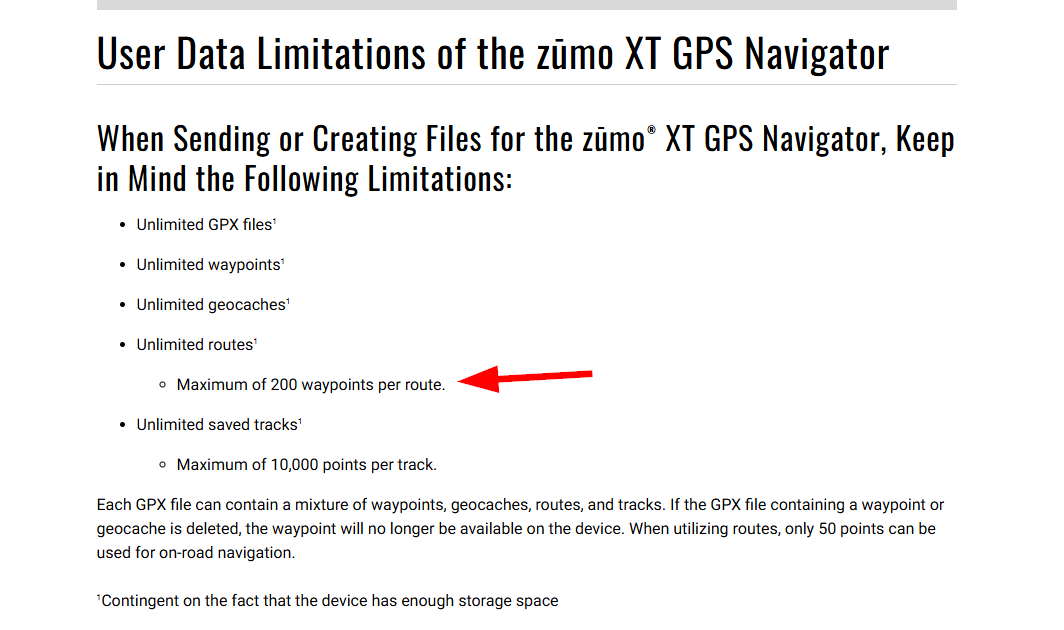
I use a Garmin Zumo XT device and my Garmin can handle up to 200 waypoints, so i try to stay underneath this number. If a route is longer and i need more than 200 waypoints, i split the route in 2 parts.
I only use the "soft wayppoints" not the "hard waypoints".
| MRA Gold Member |
| Garmin Zumo XT + BMW K1200GT |
| MRA Next + Kawasaki Z650 | -
If i have a route where i have lost of left./right turns, i place a waypoint after each turn (not directly ofcourse, some few hundred meters after the turn). Long stretches which goes for several kilometers with no turns or side roads i place 1 or 2 waypoints depending the lengt of that stretch.
I use a Garmin Zumo XT device and my Garmin can handle up to 200 waypoints, so i try to stay underneath this number. If a route is longer and i need more than 200 waypoints, i split the route in 2 parts.
I only use the "soft wayppoints" not the "hard waypoints".
@Nomko-Nomden if a route - comming from MRA-Routeplanner - has to many Shaping- or Viapoints, Gamin XT is splitting the route automatically into 2 or more parts. You don't need to do this in forefront manually.
Nothing is impossible ;-)
In past: GARMIN Zumo 210->GARMIN Zumo 395->GARMIN XT=> now: DMD T865-X + MyRoute-App, LocusMaps, OsmAnd.
In past: GARMIN MapSource ->GARMIN BaseCamp->Tyre->Kurviger->Calimoto=> now: MRA-Routplanner. -
If i have a route where i have lost of left./right turns, i place a waypoint after each turn (not directly ofcourse, some few hundred meters after the turn). Long stretches which goes for several kilometers with no turns or side roads i place 1 or 2 waypoints depending the lengt of that stretch.
I use a Garmin Zumo XT device and my Garmin can handle up to 200 waypoints, so i try to stay underneath this number. If a route is longer and i need more than 200 waypoints, i split the route in 2 parts.
I only use the "soft wayppoints" not the "hard waypoints".
@Nomko-Nomden an XT canot handke mire then 31 vuapoint.
In General you could say a shapingpoints Evers 4 or 5 km. More important is to at the route. Compare it to the TomTom and OSM maps an try to minimise the shapingpoints, sometimes less is more. If the route is made correctly, the XT will follow your desired route. Make shure that all the shapingpoints are ON the route. If not the XT will see the possibility the mess op your route
Have funHonda Goldwing GL1500,
Honda Silverwing GL 650
DMD2 T865X 8 inch Android tablet using MRA next for navigation
Garmin XT sold
Samsung S24FE mounted on a Quadlock and using Android Auto in my car -
@Nomko-Nomden an XT canot handke mire then 31 vuapoint.
In General you could say a shapingpoints Evers 4 or 5 km. More important is to at the route. Compare it to the TomTom and OSM maps an try to minimise the shapingpoints, sometimes less is more. If the route is made correctly, the XT will follow your desired route. Make shure that all the shapingpoints are ON the route. If not the XT will see the possibility the mess op your route
Have funWaarom meld de Garmin webiste dan dat de XT 200 waypoints aankan??? Waar komt die 31 vandaan???
https://support.garmin.com/en-US/?faq=OOuUro8osN5gs61OhANsf5

| MRA Gold Member |
| Garmin Zumo XT + BMW K1200GT |
| MRA Next + Kawasaki Z650 | -
@Nomko-Nomden if a route - comming from MRA-Routeplanner - has to many Shaping- or Viapoints, Gamin XT is splitting the route automatically into 2 or more parts. You don't need to do this in forefront manually.
@Guzzist said in How many softpoints and hardpoints do you use?:
@Nomko-Nomden if a route - comming from MRA-Routeplanner - has to many Shaping- or Viapoints, Gamin XT is splitting the route automatically into 2 or more parts. You don't need to do this in forefront manually.
Correct! BUT... BUT... I don't want my XT to split up the route in a way that it likes for itself.
If i make a route which takes maore than 200 waypoints, i make the decision were to cut the route.
-
Waarom meld de Garmin webiste dan dat de XT 200 waypoints aankan??? Waar komt die 31 vandaan???
https://support.garmin.com/en-US/?faq=OOuUro8osN5gs61OhANsf5
@Nomko-Nomden Garmin “waypoints” are via points in MRA speak. On the XT you can have 135 shaping points between via points. Practically you never bump into these limits.
-
Waarom meld de Garmin webiste dan dat de XT 200 waypoints aankan??? Waar komt die 31 vandaan???
https://support.garmin.com/en-US/?faq=OOuUro8osN5gs61OhANsf5
@Nomko-Nomden klopt maar dat is het totaal van shapingpoints en viapoints. Die laatste mogen er maar 31 zijn, viapoints dus
Hello! It looks like you're interested in this conversation, but you don't have an account yet.
Getting fed up of having to scroll through the same posts each visit? When you register for an account, you'll always come back to exactly where you were before, and choose to be notified of new replies (either via email, or push notification). You'll also be able to save bookmarks and upvote posts to show your appreciation to other community members.
With your input, this post could be even better 💗
Register Login-
014191
-
0606.5k
-
1906.1k
-
0536
-
011180
-
024732
-
0350
-
255612.9k