Walking route created with MRA
-
I recently created a walking route using MRA. As a fair amount of the route was going to be not on roads, but in trails and fields, I set the route to offroad (Toolkit > Offroad) in the Routeplanner. I then manually traced the route and placed several shaping points as well as via points, some with added notes.
When time came to use the route in the app I found a few issues:
- The track line which joins all the waypoints doesn't show in the app.
- If I tap on any of the points in the route nothing happens, so I can't see any of the notes I added to them.
If I make a copy of the route and tick off the offroad option, I can now see the route line, although it's all mangled as the app is trying to use roads for portions of the route that are meant to be off road, but I still can't get anything when I tap on the waypoints.
Am I doing something wrong? Is there a way to create a walking route that shows the route line, and also where I can get access to the notes I've added to my waypoints?
--
Jorge -
I recently created a walking route using MRA. As a fair amount of the route was going to be not on roads, but in trails and fields, I set the route to offroad (Toolkit > Offroad) in the Routeplanner. I then manually traced the route and placed several shaping points as well as via points, some with added notes.
When time came to use the route in the app I found a few issues:
- The track line which joins all the waypoints doesn't show in the app.
- If I tap on any of the points in the route nothing happens, so I can't see any of the notes I added to them.
If I make a copy of the route and tick off the offroad option, I can now see the route line, although it's all mangled as the app is trying to use roads for portions of the route that are meant to be off road, but I still can't get anything when I tap on the waypoints.
Am I doing something wrong? Is there a way to create a walking route that shows the route line, and also where I can get access to the notes I've added to my waypoints?
Use the OSM map, open the route and tick on the compass needle then start walking
Garmin Zumo XT3/XT2/XT/BMW Connected Ride Navigator/MyRouteapp (The App)/...
Een dag niet gelachen is een dag niet geleefd / Een route is net zo goed als deze uitgezet is. -
Use the OSM map, open the route and tick on the compass needle then start walking
@Hans-van-de-Ven-MR-MRA
Thank you for your reply.When you say "tick on the compass" I assume you mean the icon on the bottom left of the app? If so, that's what I was already doing. When I to that I don't see the trail lines, and I don't get anything when I tap on the waypoints.
--
Jorge -
@Hans-van-de-Ven-MR-MRA
Thank you for your reply.When you say "tick on the compass" I assume you mean the icon on the bottom left of the app? If so, that's what I was already doing. When I to that I don't see the trail lines, and I don't get anything when I tap on the waypoints.
Right, just follow the line
Garmin Zumo XT3/XT2/XT/BMW Connected Ride Navigator/MyRouteapp (The App)/...
Een dag niet gelachen is een dag niet geleefd / Een route is net zo goed als deze uitgezet is. -
Right, just follow the line
@Hans-van-de-Ven-MR-MRA But that's just the thing. I don't see a line. I have to scroll around until I find the next waypoint, but there's no line connecting them
--
Jorge -
@Hans-van-de-Ven-MR-MRA But that's just the thing. I don't see a line. I have to scroll around until I find the next waypoint, but there's no line connecting them
Did you create a route?
-
@Hans-van-de-Ven-MR-MRA But that's just the thing. I don't see a line. I have to scroll around until I find the next waypoint, but there's no line connecting them
@Jorge-del-Valle
The route must be made using the planning map from OpenStreetMap and you must have By foot (walking) selected as transport mode.
Open the route and tap the location marker twice, (I have arrowed it in my screenshot) then as you walk the map will move with you as you follow the line. There are no turn by turn navigation instructions.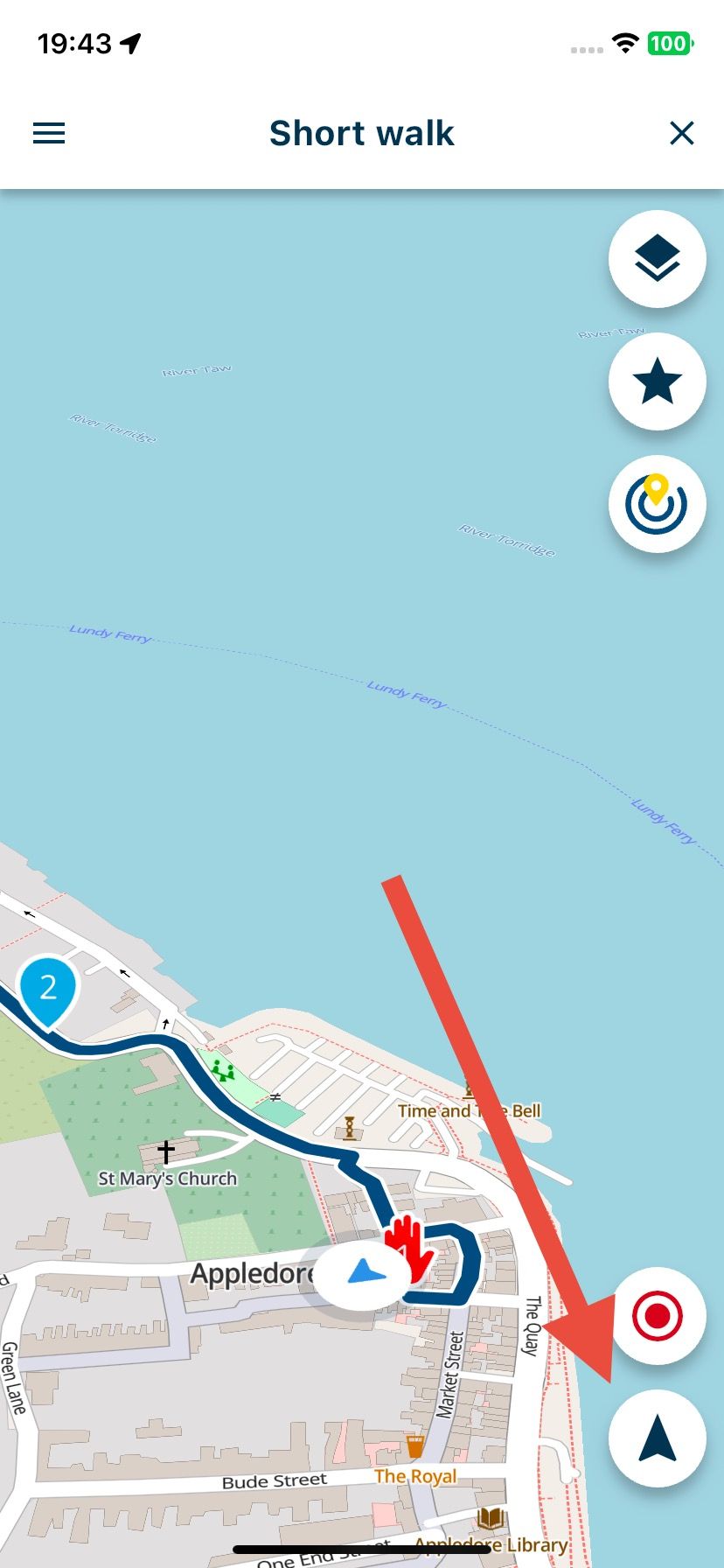
-
Yes, that's what I'm doing. But, at least for me, if I have the route set to "offroad" (which I need to as part of the route is in the middle of the countryside), I don't get a line to follow when I use the app.
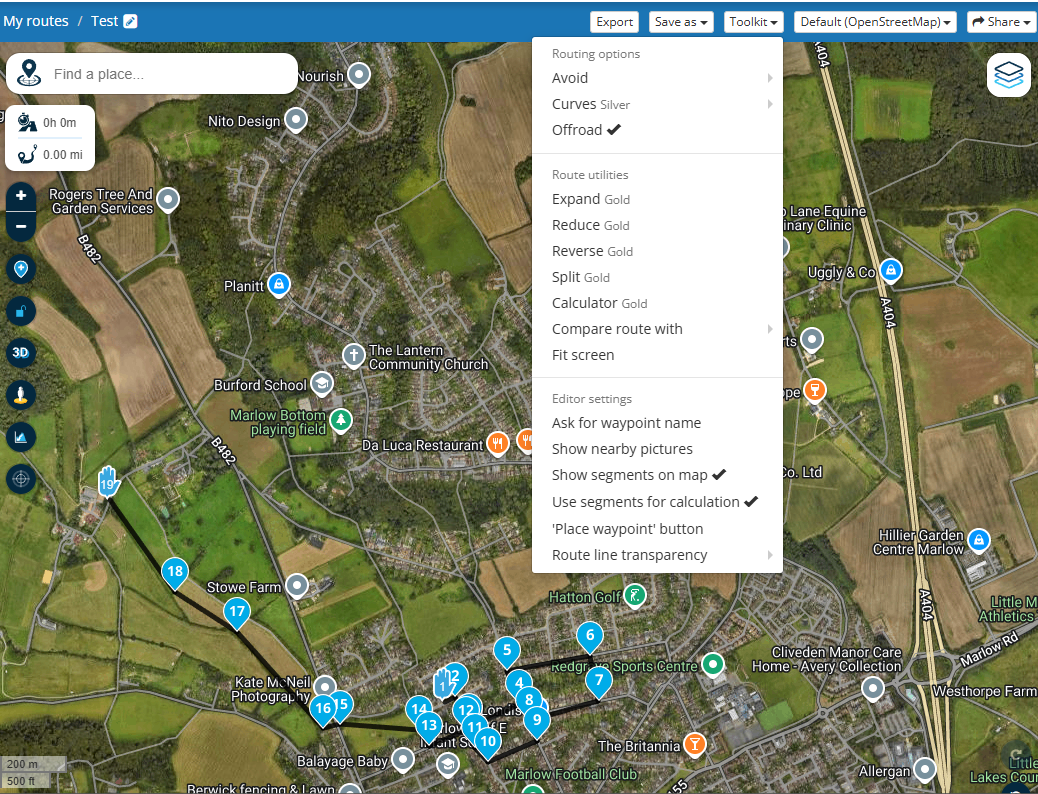
As an example, here's a test walking route I've made in the route planner, set to offroad:
And this is how the same route appears in the Android app (zoomed in to the start of the route):
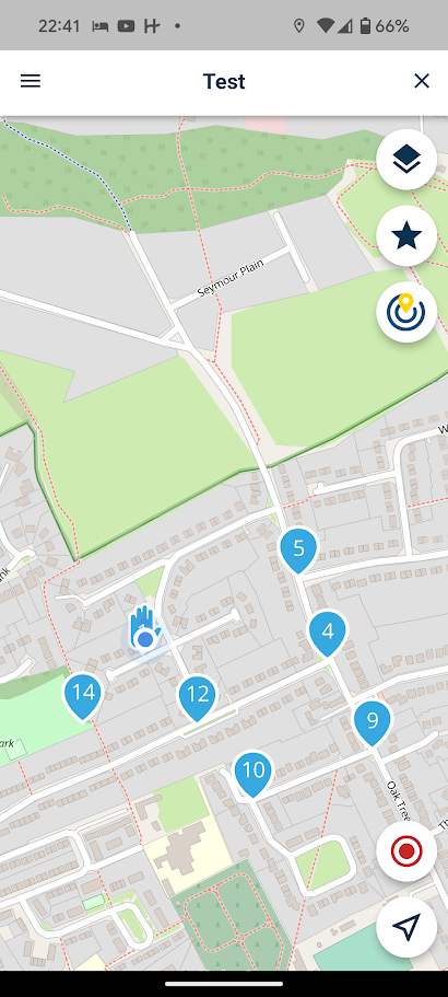
As you can see, in the Android app version there are no lines for the route joining the navigation points.
--
Jorge -
Yes, that's what I'm doing. But, at least for me, if I have the route set to "offroad" (which I need to as part of the route is in the middle of the countryside), I don't get a line to follow when I use the app.
As an example, here's a test walking route I've made in the route planner, set to offroad:
And this is how the same route appears in the Android app (zoomed in to the start of the route):
As you can see, in the Android app version there are no lines for the route joining the navigation points.
@Jorge-del-Valle I should also clarify that I don't get a line when I double-tap the location marker twice, as Nick instructed. For me there's no line to follow.
--
Jorge -
@Jorge-del-Valle I should also clarify that I don't get a line when I double-tap the location marker twice, as Nick instructed. For me there's no line to follow.
@Jorge-del-Valle, This clearly is a routed route. Disable offroad and try to load it again. I have been hiking this way through Luxemburg without a problem. What I did was download the GPX 1.1 track only version, and start that one from the Downloads folder. You will lose Waypoints though.
-
@Jorge-del-Valle I should also clarify that I don't get a line when I double-tap the location marker twice, as Nick instructed. For me there's no line to follow.
@Jorge-del-Valle, To add to myself, I just tested the offroad setting and it does indeed match your description exactly. If you want to walk offroad route, it is better to download it as a GPX, track only, and open that one in MRA.
I am just an enthusiastic MRA user, and hope you will be one too!
Most motorcycle problems are caused by the nut that connects the handlebar to the saddle.
Check out RideSleepRepeat.eu, a biker community for sharing stays across Europe
-
@Jorge-del-Valle, To add to myself, I just tested the offroad setting and it does indeed match your description exactly. If you want to walk offroad route, it is better to download it as a GPX, track only, and open that one in MRA.
@Con-Hennekens Thank you both. I'll give that a try. Shame that I will lose waypoints as I would have loved to be able to keep notes, but I can live with that.
Hello! It looks like you're interested in this conversation, but you don't have an account yet.
Getting fed up of having to scroll through the same posts each visit? When you register for an account, you'll always come back to exactly where you were before, and choose to be notified of new replies (either via email, or push notification). You'll also be able to save bookmarks and upvote posts to show your appreciation to other community members.
With your input, this post could be even better 💗
Register Login-
011144
-
-436953
-
010174
-
1313231
-
0101.3k
-
08737
-
03104
-
0498