How to incorporate public gravel roads when planning a route
-
Hi everyone new to the group here looking forward to planning some good routes this year I’ve just splashed out for gold membership.. as planing a trip with the boys in Spain .. great planning app in fairness which is why I decided to sign up for gold membership.. only thing we were hoping to do some official public light gravel roads ( not tet routes ) around where we’re staying we all use tomtom riders so I use the tomtom map in route lab to map routes as advised but should I use a different map? when I plan a route on route lab it only seems to plan all tarmac roads I’ve tried checking all the boxes in the toolkit all to no avail… anyone know how to fix this
Thanks in advance � -
Hi everyone new to the group here looking forward to planning some good routes this year I’ve just splashed out for gold membership.. as planing a trip with the boys in Spain .. great planning app in fairness which is why I decided to sign up for gold membership.. only thing we were hoping to do some official public light gravel roads ( not tet routes ) around where we’re staying we all use tomtom riders so I use the tomtom map in route lab to map routes as advised but should I use a different map? when I plan a route on route lab it only seems to plan all tarmac roads I’ve tried checking all the boxes in the toolkit all to no avail… anyone know how to fix this
Thanks in advance �@derek-c
Do you have unmarked this option?
-
Explicit preference of gravel roads is not supported.
Best would be to plan in OSM as they have more gravel roads mapped and then convert the route to TomTom. -
Explicit preference of gravel roads is not supported.
Best would be to plan in OSM as they have more gravel roads mapped and then convert the route to TomTom.Thanks for the speedy reply much appreciated i’m new to all this route planning what is this OSM is it another app related to my route app if not, can I download it to the MyRoute-app to view it and change it if necessary? app?@Corjan-Meijerink
-
Thanks for the speedy reply much appreciated i’m new to all this route planning what is this OSM is it another app related to my route app if not, can I download it to the MyRoute-app to view it and change it if necessary? app?@Corjan-Meijerink
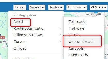
@derek-c Oh sorry, just select OpenStreetMap where it says "TomTom" in the screenshot above. This will allow you to use that map which quite often includes more offroad roads.
-
Thanks for the speedy reply much appreciated i’m new to all this route planning what is this OSM is it another app related to my route app if not, can I download it to the MyRoute-app to view it and change it if necessary? app?@Corjan-Meijerink
-
Hi everyone new to the group here looking forward to planning some good routes this year I’ve just splashed out for gold membership.. as planing a trip with the boys in Spain .. great planning app in fairness which is why I decided to sign up for gold membership.. only thing we were hoping to do some official public light gravel roads ( not tet routes ) around where we’re staying we all use tomtom riders so I use the tomtom map in route lab to map routes as advised but should I use a different map? when I plan a route on route lab it only seems to plan all tarmac roads I’ve tried checking all the boxes in the toolkit all to no avail… anyone know how to fix this
Thanks in advance �@derek-c You are aware that if a road that you planned using another map (e.g. OSM) than that of TomTom, the software of the TomTom Rider will automatically choose to take another road on its map when a gpx is imported in a TomTom Rider?
-
Hi everyone new to the group here looking forward to planning some good routes this year I’ve just splashed out for gold membership.. as planing a trip with the boys in Spain .. great planning app in fairness which is why I decided to sign up for gold membership.. only thing we were hoping to do some official public light gravel roads ( not tet routes ) around where we’re staying we all use tomtom riders so I use the tomtom map in route lab to map routes as advised but should I use a different map? when I plan a route on route lab it only seems to plan all tarmac roads I’ve tried checking all the boxes in the toolkit all to no avail… anyone know how to fix this
Thanks in advance �@derek-c Just for your information and from my experience as an ex TT user, of all the GPS devices available, the TomTom Rider is least likely to use gravel roads. That's not to say that it won't, if you can plan your route on the TT planning map there's a good chance that your Rider will guide you.
As Corjan has already stated, the OSM map shows gravel roads better. If I was you I would plan on the TomTom planning map and use the OSM overlay map.
Think of the overlay maps as clear sheets with extra information that you lay over the planning map, the planning map underneath does all the calculations.
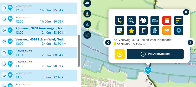
In my example below, I am using the TomTom planning map and I have the OpenStreetMap (OSM) open.
Route points 2, 3, 4 and 5 are all off road. You can see that the TomTom planning map has drawn a line for 2, 4 and 5 but not for 3. So in this situation, you could either make a mental note about route point 3 or just delete it.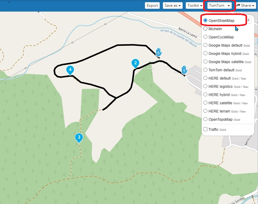
Always willing to help if I can.
Triumph Tiger 1200 XRT called Tina.
MRA Navigation Next and SilverFox BJ8 -
@derek-c You are aware that if a road that you planned using another map (e.g. OSM) than that of TomTom, the software of the TomTom Rider will automatically choose to take another road on its map when a gpx is imported in a TomTom Rider?
@Rob-Veerman yes was thinking that might be the case so how do I fix this? I originally bought the gold membership thinking that the off-road map section would cater for dirt roads


-
@derek-c Just for your information and from my experience as an ex TT user, of all the GPS devices available, the TomTom Rider is least likely to use gravel roads. That's not to say that it won't, if you can plan your route on the TT planning map there's a good chance that your Rider will guide you.
As Corjan has already stated, the OSM map shows gravel roads better. If I was you I would plan on the TomTom planning map and use the OSM overlay map.
Think of the overlay maps as clear sheets with extra information that you lay over the planning map, the planning map underneath does all the calculations.
In my example below, I am using the TomTom planning map and I have the OpenStreetMap (OSM) open.
Route points 2, 3, 4 and 5 are all off road. You can see that the TomTom planning map has drawn a line for 2, 4 and 5 but not for 3. So in this situation, you could either make a mental note about route point 3 or just delete it.@Nick-Carthew didn't tried it, but perhaps setting the activity profile to pedestrian may help?
SP2820, 550, 660, 590, XT. Mapsource, Tyre (met de nodige conversaties tot hierboven), Kurviger, Routeyou, MRA Gold sinds het begin, MRA Next app, App68studio,.. en BC natuurlijk
-
@Nick-Carthew didn't tried it, but perhaps setting the activity profile to pedestrian may help?
@Guzt The TomTom Rider does not recognise walking routes.
-
@Rob-Veerman yes was thinking that might be the case so how do I fix this? I originally bought the gold membership thinking that the off-road map section would cater for dirt roads
@derek-c said in How to incorporate public gravel roads when planning a route:
@Rob-Veerman yes was thinking that might be the case so how do I fix this? I originally bought the gold membership thinking that the off-road map section would cater for dirt roads
The limiting factor here is the TomTom Rider, they are just not designed for off road navigation.
-
@Rob-Veerman yes was thinking that might be the case so how do I fix this? I originally bought the gold membership thinking that the off-road map section would cater for dirt roads
@derek-c There's no real fix for this. The TomTom Rider is an excellent device and far more user friendly than the Garmin devices, but the problem is - like I wrote - that it will not take a road that is not in its map, it will recalculate the route and will look for roads on its maps. Normally not a big problem if it's just a matter of taking another street or a nearby side road. But it's a more serious problem if you want to go riding off road. The TomTom Rider will always recalculate another route that it will find on the map that is built in. The software is just designed that way. It's not a device to be used for long distance off roading. What I have done in the past (when I used the TomTom Rider) was the following: I stopped the route, started it again, did not press on the button 'Ride', followed the cursor while riding to a road that is part of the designed route and then press on 'Ride' the moment I had reached the original route. That looks a bit like the Garmin where you can switch off the recalculating (but you can't switch that off in the Rider). But that's not a real option for serious off roading. The limitations are in the software of the TomTom Rider (and at this moment you can't use another map in the Rider than the one that's built in). Being a long distance rider taking all kinds of roads that are not always on the TomTom built in maps I switched to Garmin. For creating routes you can off course use the TomTom map in MRA web planner. Part of the problem is that you are riding with others that still might use a TomTom. They will have to follow the leader.
-
@derek-c There's no real fix for this. The TomTom Rider is an excellent device and far more user friendly than the Garmin devices, but the problem is - like I wrote - that it will not take a road that is not in its map, it will recalculate the route and will look for roads on its maps. Normally not a big problem if it's just a matter of taking another street or a nearby side road. But it's a more serious problem if you want to go riding off road. The TomTom Rider will always recalculate another route that it will find on the map that is built in. The software is just designed that way. It's not a device to be used for long distance off roading. What I have done in the past (when I used the TomTom Rider) was the following: I stopped the route, started it again, did not press on the button 'Ride', followed the cursor while riding to a road that is part of the designed route and then press on 'Ride' the moment I had reached the original route. That looks a bit like the Garmin where you can switch off the recalculating (but you can't switch that off in the Rider). But that's not a real option for serious off roading. The limitations are in the software of the TomTom Rider (and at this moment you can't use another map in the Rider than the one that's built in). Being a long distance rider taking all kinds of roads that are not always on the TomTom built in maps I switched to Garmin. For creating routes you can off course use the TomTom map in MRA web planner. Part of the problem is that you are riding with others that still might use a TomTom. They will have to follow the leader.
@Rob-Veerman is like to say.thanks to everyone who’s commented what a great forum this is .. pity as a new member on here I have to wait 60 mins to post a reply
 hence the reason for the shoutouts hopefully that will change soon it’s looking like I may have to do as you say rob and try budget for a garmin pity cause I like the ease of use with tomtom I found garmins of the past hard to get used to I can see myself leading the whole trip now cause everyone else has tomtoms
 -
@derek-c There's no real fix for this. The TomTom Rider is an excellent device and far more user friendly than the Garmin devices, but the problem is - like I wrote - that it will not take a road that is not in its map, it will recalculate the route and will look for roads on its maps. Normally not a big problem if it's just a matter of taking another street or a nearby side road. But it's a more serious problem if you want to go riding off road. The TomTom Rider will always recalculate another route that it will find on the map that is built in. The software is just designed that way. It's not a device to be used for long distance off roading. What I have done in the past (when I used the TomTom Rider) was the following: I stopped the route, started it again, did not press on the button 'Ride', followed the cursor while riding to a road that is part of the designed route and then press on 'Ride' the moment I had reached the original route. That looks a bit like the Garmin where you can switch off the recalculating (but you can't switch that off in the Rider). But that's not a real option for serious off roading. The limitations are in the software of the TomTom Rider (and at this moment you can't use another map in the Rider than the one that's built in). Being a long distance rider taking all kinds of roads that are not always on the TomTom built in maps I switched to Garmin. For creating routes you can off course use the TomTom map in MRA web planner. Part of the problem is that you are riding with others that still might use a TomTom. They will have to follow the leader.
@Rob-Veerman I’m wondering if it might be an idea to use The Route lab on my computer to create the routes and then use the MyRoute-app on my iPhone with off-line maps of Spain
(so not relying on phone data coverage ) but which map in the tool kit works best with the MyRoute- app would do you recommend? -
@Rob-Veerman I’m wondering if it might be an idea to use The Route lab on my computer to create the routes and then use the MyRoute-app on my iPhone with off-line maps of Spain
(so not relying on phone data coverage ) but which map in the tool kit works best with the MyRoute- app would do you recommend?@derek-c That is certainly a possibility. If you use the HERE-map you might still miss a few off road tracks.
You still have some time left before departure, so you could also try the (free) Maps.me app. Just try it out.
Free download in the App store and once the app is installed OSM maps are also free to download. With Maps.me and the routes that go off road on your phone you can still use your TomTom for the remaining (parts of) your routes. No need to buy a Garmin then. I have used Maps.me more than several times when being far away.
-
@derek-c That is certainly a possibility. If you use the HERE-map you might still miss a few off road tracks.
You still have some time left before departure, so you could also try the (free) Maps.me app. Just try it out.
Free download in the App store and once the app is installed OSM maps are also free to download. With Maps.me and the routes that go off road on your phone you can still use your TomTom for the remaining (parts of) your routes. No need to buy a Garmin then. I have used Maps.me more than several times when being far away.
@Rob-Veerman … ye seems it might be a bit of a faff looking at 2 devices at once while trying to figure out what’s what and concentrate on the gravel roads o want something simple and straightforward
 I
I
might have to bite the bullet and get a garmin do you know what’s the minimum software version needed when it comes to garmin satnavs that work seemlessly with My route ? -
@Rob-Veerman … ye seems it might be a bit of a faff looking at 2 devices at once while trying to figure out what’s what and concentrate on the gravel roads o want something simple and straightforward
I
might have to bite the bullet and get a garmin do you know what’s the minimum software version needed when it comes to garmin satnavs that work seemlessly with My route ?@derek-c if you are really in for a Garmin I would go for the Zumo XT. There’s no need to go for the XT2. GPX files made with MRA web planner can easily be transferred to the Zumo XT by using the app of MRA app and then have them sent to the app Garmin Drive that is paired to the ZumoXT (the GPX file can be sent via Bluetooth).
-
@derek-c if you are really in for a Garmin I would go for the Zumo XT. There’s no need to go for the XT2. GPX files made with MRA web planner can easily be transferred to the Zumo XT by using the app of MRA app and then have them sent to the app Garmin Drive that is paired to the ZumoXT (the GPX file can be sent via Bluetooth).
@Rob-Veerman @Rob-Veerman thanks you’ve been most helpful really appreciate the quick reply’s

I’ll keep an eye out for the xt and see if I can get any deals but in the meantime I’ve just downloaded all of Spain onto my phone for off line use so like i was saying before I’m hoping to hopefully plan a route with one of the best maps in the toolkit don’t know yet which one on route lab and then when the time comes and I arrive in Spain the plan is to just switch to off line maps and on the right track there? -
@Rob-Veerman @Rob-Veerman thanks you’ve been most helpful really appreciate the quick reply’s
I’ll keep an eye out for the xt and see if I can get any deals but in the meantime I’ve just downloaded all of Spain onto my phone for off line use so like i was saying before I’m hoping to hopefully plan a route with one of the best maps in the toolkit don’t know yet which one on route lab and then when the time comes and I arrive in Spain the plan is to just switch to off line maps and on the right track there?@derek-c Good luck and have fun. Remember the English saying: 'Don't put all your eggs in one basket'.
Hello! It looks like you're interested in this conversation, but you don't have an account yet.
Getting fed up of having to scroll through the same posts each visit? When you register for an account, you'll always come back to exactly where you were before, and choose to be notified of new replies (either via email, or push notification). You'll also be able to save bookmarks and upvote posts to show your appreciation to other community members.
With your input, this post could be even better 💗
Register Login-
0685
-
0592
-
09139
-
012259
-
05115
-
1413231
-
0390
-
0334