Skip to content
  • Categories
  • Recent
  • Popular
  • Support
  • MyRoute-app
Collapse
Brand Logo

MRA Community Forum

  1. Home
  2. MyRoute-app Routeplanner
  3. [Web] Problems, Bugs and other Issues
  4. Riding mode not specific enough

Riding mode not specific enough

Scheduled Pinned Locked Moved [Web] Problems, Bugs and other Issues
10 Posts 4 Posters 2.0k Views 3 Watching
  • Oldest to Newest
  • Newest to Oldest
  • Most Votes
Reply
  • Reply as topic
Log in to reply
This topic has been deleted. Only users with topic management privileges can see it.
  • Converted_ Offline
    Converted_ Offline
    Converted_
    wrote on last edited by
    #1

    I was trying to plan a rout with my motorbike through the german als including some specific points. I was looking for specific locations that can be reached with the motorbike, taking into account the the navigation is not considering seasonal blockings. I was trying to drive from Schlipfhalden via Fuchsalm (Stop point) to Gschwend. I was trying different methods (TomTom/HERE) under the driving mode motorbike, with the following result.
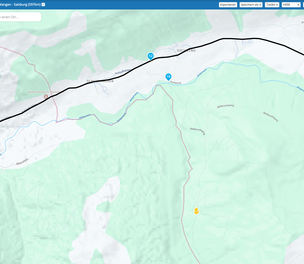
    Bildschirmfoto 2025-01-02 um 17.10.26.png
    only by using OpenStreetMap I received the expected result
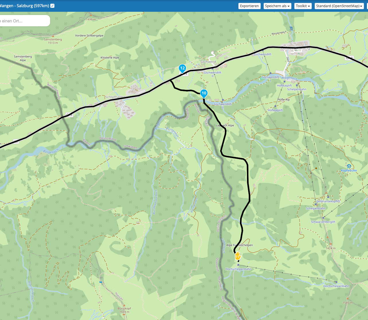
    Bildschirmfoto 2025-01-02 um 17.13.37.png
    But then received the message that the selected riding mode does only function with TomTom and HERE. Why is that the case? Shouldn't also HERE and TomTom be able to route on this street? Where can I select septic capabilities of my bike?

    Con Hennekens 1 Reply Last reply
    0
    • Rob Kelley Offline
      Rob Kelley Offline
      Rob Kelley
      wrote on last edited by Rob Kelley
      #2

      I've managed to repliacte this issue using the same location and got the same issue, this is probaly a issue with HERE maps rather than MRA.
      You can choose to use OSM mapping but you 'may' get some strange routing, or it maybe ok.
      In this instance I would place a Waypoint at the junction called 'turn left or right' here to get you on the correct route and then follow the road to 11.
      Sometimes we have to get creative.

      GSA1250
      HD Street Glide
      HD Sport Glide
      XT500 x 2

      Converted_ 1 Reply Last reply
      0
      • Rob Kelley Rob Kelley

        I've managed to repliacte this issue using the same location and got the same issue, this is probaly a issue with HERE maps rather than MRA.
        You can choose to use OSM mapping but you 'may' get some strange routing, or it maybe ok.
        In this instance I would place a Waypoint at the junction called 'turn left or right' here to get you on the correct route and then follow the road to 11.
        Sometimes we have to get creative.

        Converted_ Offline
        Converted_ Offline
        Converted_
        wrote on last edited by
        #3

        @Rob-Kelley thank you very much for your response. I already thought it might be an issue of my equipment.
        Sure I will be creative not to miss the junction, but to be honest that’s like being back in „base camp“. I might be wrong, but this road should be picked by MRA. Would be nice to understand, why it’s not picked.

        Rob Kelley 1 Reply Last reply
        0
        • Converted_ Converted_

          @Rob-Kelley thank you very much for your response. I already thought it might be an issue of my equipment.
          Sure I will be creative not to miss the junction, but to be honest that’s like being back in „base camp“. I might be wrong, but this road should be picked by MRA. Would be nice to understand, why it’s not picked.

          Rob Kelley Offline
          Rob Kelley Offline
          Rob Kelley
          wrote on last edited by
          #4

          @Converted_
          As I mentioned, I think the issue is with the HERE mapping which is a 3rd party service and not an issue with MRA.

          GSA1250
          HD Street Glide
          HD Sport Glide
          XT500 x 2

          1 Reply Last reply
          1
          • Converted_ Converted_

            I was trying to plan a rout with my motorbike through the german als including some specific points. I was looking for specific locations that can be reached with the motorbike, taking into account the the navigation is not considering seasonal blockings. I was trying to drive from Schlipfhalden via Fuchsalm (Stop point) to Gschwend. I was trying different methods (TomTom/HERE) under the driving mode motorbike, with the following result.
            Bildschirmfoto 2025-01-02 um 17.10.26.png
            only by using OpenStreetMap I received the expected result
            Bildschirmfoto 2025-01-02 um 17.13.37.png
            But then received the message that the selected riding mode does only function with TomTom and HERE. Why is that the case? Shouldn't also HERE and TomTom be able to route on this street? Where can I select septic capabilities of my bike?

            Con Hennekens Offline
            Con Hennekens Offline
            Con Hennekens
            Alpha tester
            wrote on last edited by
            #5

            @Converted_, the entry of this road looks like this:
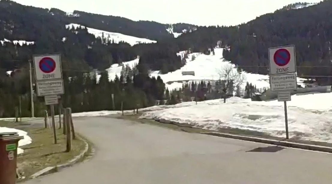
            37c55a6d-a612-424a-acdf-aa5f486fcff9-image.png

            I am not really sure, but I think the sign says "Forschungsweg", and the smaller text probably says it is not allowed for other then local traffic or "Anlieger". So in this specific case HERE might just be the correct one 😉

            I am just an enthusiastic MRA user, and hope you will be one too!

            Most motorcycle problems are caused by the nut that connects the handlebar to the saddle.

            Check out RideSleepRepeat.eu, a biker community for sharing stays across Europe

            Converted_ 1 Reply Last reply
            0
            • Con Hennekens Con Hennekens

              @Converted_, the entry of this road looks like this:
              37c55a6d-a612-424a-acdf-aa5f486fcff9-image.png

              I am not really sure, but I think the sign says "Forschungsweg", and the smaller text probably says it is not allowed for other then local traffic or "Anlieger". So in this specific case HERE might just be the correct one 😉

              Converted_ Offline
              Converted_ Offline
              Converted_
              wrote on last edited by
              #6

              @Con-Hennekens said in Riding mode not specific enough:

              @Converted_, the entry of this road looks like this:
              37c55a6d-a612-424a-acdf-aa5f486fcff9-image.png

              I am not really sure, but I think the sign says "Forschungsweg", and the smaller text probably says it is not allowed for other then local traffic or "Anlieger". So in this specific case HERE might just be the correct one 😉

              Hi Con-Hennekens,
              than you very much for your comment.
              You might be correct with your interpretation of the sign. But what I have uploaded is an official rout published by TourenFahrer and to be honest I can hardly imagine that they propose to drive a road that would not be legal. Additional to that if it would not be legal to drive that road how come TomTom make this possible.

              Anyway, I have a work around and maybe that will help me in the future.

              Con Hennekens 1 Reply Last reply
              0
              • Converted_ Converted_

                @Con-Hennekens said in Riding mode not specific enough:

                @Converted_, the entry of this road looks like this:
                37c55a6d-a612-424a-acdf-aa5f486fcff9-image.png

                I am not really sure, but I think the sign says "Forschungsweg", and the smaller text probably says it is not allowed for other then local traffic or "Anlieger". So in this specific case HERE might just be the correct one 😉

                Hi Con-Hennekens,
                than you very much for your comment.
                You might be correct with your interpretation of the sign. But what I have uploaded is an official rout published by TourenFahrer and to be honest I can hardly imagine that they propose to drive a road that would not be legal. Additional to that if it would not be legal to drive that road how come TomTom make this possible.

                Anyway, I have a work around and maybe that will help me in the future.

                Con Hennekens Offline
                Con Hennekens Offline
                Con Hennekens
                Alpha tester
                wrote on last edited by
                #7

                Multiple thoughts really. Maybe the signs are quite new and not all map providers are aware. Or maybe the signs have been removed, and StreetView as well as HERE are behind. Many possibilities 😉

                I am just an enthusiastic MRA user, and hope you will be one too!

                Most motorcycle problems are caused by the nut that connects the handlebar to the saddle.

                Check out RideSleepRepeat.eu, a biker community for sharing stays across Europe

                1 Reply Last reply
                1
                • martin-phogel.de Offline
                  martin-phogel.de Offline
                  martin-phogel.de
                  wrote on last edited by martin-phogel.de
                  #8

                  It's a "no parking zone", a "Rettungsweg" / "escape lane(?)", private property (typically means "use at your own risk") but not restricted.
                  OSM shows no restriction either.
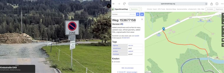
                  pic.jpg

                  Should be allowed for cars and motorbikes.

                  Converted_ 1 Reply Last reply
                  1
                  • martin-phogel.de martin-phogel.de

                    It's a "no parking zone", a "Rettungsweg" / "escape lane(?)", private property (typically means "use at your own risk") but not restricted.
                    OSM shows no restriction either.

                    pic.jpg

                    Should be allowed for cars and motorbikes.

                    Converted_ Offline
                    Converted_ Offline
                    Converted_
                    wrote on last edited by
                    #9

                    @Martin-Wilcke thank you very much for clarification!

                    1 Reply Last reply
                    0
                    • martin-phogel.de Offline
                      martin-phogel.de Offline
                      martin-phogel.de
                      wrote on last edited by
                      #10

                      Out of curiosity, I registered for the "HERE map creator" and had a look:
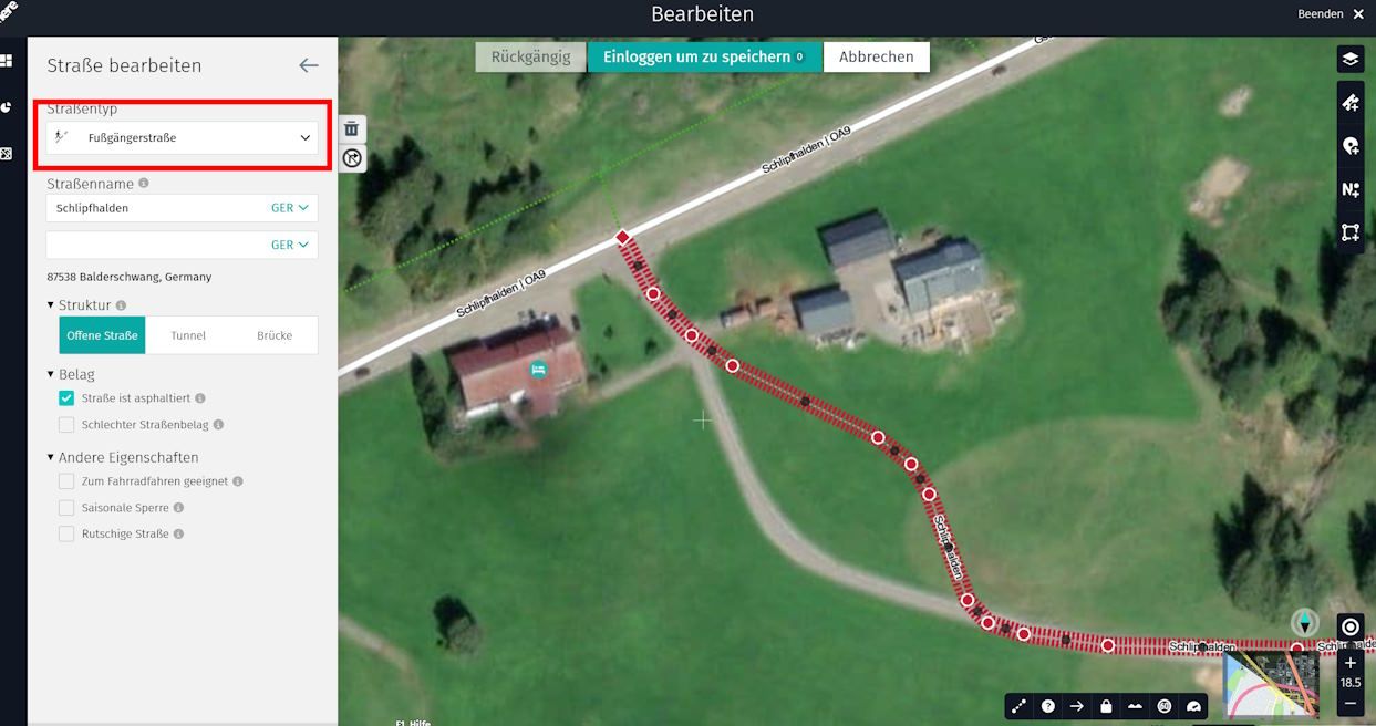
                      pic2.jpg

                      The information on the HERE map seems to be outdated, but as I have no local knowledge of this area, I don't want to change that.

                      1 Reply Last reply
                      0

                      Hello! It looks like you're interested in this conversation, but you don't have an account yet.

                      Getting fed up of having to scroll through the same posts each visit? When you register for an account, you'll always come back to exactly where you were before, and choose to be notified of new replies (either via email, or push notification). You'll also be able to save bookmarks and upvote posts to show your appreciation to other community members.

                      With your input, this post could be even better 💗

                      Register Login
                      Reply
                      • Reply as topic
                      Log in to reply
                      • Oldest to Newest
                      • Newest to Oldest
                      • Most Votes


                      ACTIVE USERS
                      Con Hennekens
                      Con Hennekens
                      martin-phogel.de
                      martin-phogel.de
                      Rob Kelley
                      Rob Kelley
                      Converted_
                      Converted_
                      POPULAR TOPICS
                      • GPX Versions 1.1 vs 1.2 for Garmin Visually Explained
                        Guzzist
                        Guzzist
                        7
                        166
                        11.7k

                      • HERE maps updates
                        Peter Zehentreiter
                        Peter Zehentreiter
                        0
                        4
                        105

                      • Linker in MRA kleurt blauw (alles geselecteerd)
                        Alfred Schrittwieser
                        Alfred Schrittwieser
                        0
                        10
                        186

                      • Auto skip many waypoints by itself while I was on route. [5.2.0 - 474]
                        Brian McG
                        Brian McG
                        0
                        34
                        1.3k

                      • Useful Speed Camera Information
                        Marinus van Deudekom
                        Marinus van Deudekom
                        3
                        3
                        152

                      • Route maken in TomTom kaart en vervolgens met de app navigeren
                        Bruno 7
                        Bruno 7
                        0
                        6
                        119

                      • Straatnamen worden uitgesproken
                        Theo Lammerts
                        Theo Lammerts
                        0
                        5
                        304

                      • The compas direction on the elevation circle is wrong
                        Dave J 0
                        Dave J 0
                        0
                        23
                        591

                      MY GROUPS
                      • Login

                      • Login or register to search.
                      • First post
                        Last post
                      0
                      • Categories
                      • Recent
                      • Popular
                      • Support
                      • MyRoute-app