Updated beta! 4.3.4 (372)
-
Hi all!

Before the weekend an updated beta is coming your way with the following improvements:
- Added a setting to also show shapingpoints while navigating a track
- Fixed issue with track calculation warnings and changed the general appearance of this too
- Longer duration for some alerts
- Fixed issue with track navigation for very short routes
- Stability CarPlay / Android Auto regarding syncing data between the car and the phone
Enjoy!
-
Hi all!
Before the weekend an updated beta is coming your way with the following improvements:
- Added a setting to also show shapingpoints while navigating a track
- Fixed issue with track calculation warnings and changed the general appearance of this too
- Longer duration for some alerts
- Fixed issue with track navigation for very short routes
- Stability CarPlay / Android Auto regarding syncing data between the car and the phone
Enjoy!
@Corjan-Meijerink That’s great. But with the added ability to also see shaping points in a track, what will be the main differences between a route and a track? What are the advantages or disadvantages for both?
Always willing to help if I can.
Triumph Tiger 1200 XRT called Tina.
MRA Navigation Next and SilverFox BJ8 -
@Corjan-Meijerink That’s great. But with the added ability to also see shaping points in a track, what will be the main differences between a route and a track? What are the advantages or disadvantages for both?
@Nick-Carthew, it offers great value for people who are afraid their route is not exactly as planned. Also shaping points can have info like announcements, symbols and pictures that are nice to have, but are not mandatory stops (for which you would use VIA points). The skip algorithm works a bit different, and for many people probably more logically. Like @Corjan-Meijerink said in his announcement "This might become my preferred method of navigating".
")
There are some cons to. adding POI's on the fly for example is not possible.
-
@Corjan-Meijerink That’s great. But with the added ability to also see shaping points in a track, what will be the main differences between a route and a track? What are the advantages or disadvantages for both?
@Nick-Carthew, and to add to myself: It makes it also entirely possible to plan a curvy TomTom route using TomTom toolkit, and navigate it in the MRA app, without comparing and making equal, but with the availability of all waypoint info
Personally I have always been an advocate of navigating routes instead of tracks, but this new feature changes A LOT
I am just an enthusiastic MRA user, and hope you will be one too!
Most motorcycle problems are caused by the nut that connects the handlebar to the saddle.
Check out RideSleepRepeat.eu, a biker community for sharing stays across Europe
-
@Nick-Carthew, and to add to myself: It makes it also entirely possible to plan a curvy TomTom route using TomTom toolkit, and navigate it in the MRA app, without comparing and making equal, but with the availability of all waypoint info
Personally I have always been an advocate of navigating routes instead of tracks, but this new feature changes A LOT
Thanks @Con-Hennekens But I am fully aware about what can be added to a shaping point and the difference between a shaping point and a via point.
My understanding of a track was that it is a breadcrumb trail between two points on a map, the navigation device will follow this trail exactly. Whereas a route is a series of route points where the navigation device chooses the best route between each point.
Like you I have always used routes for navigation but I might change to track navigation now.
But if a track can now contain both shaping points and via points I can't see why we would still have the option of both route and track?
This is why I would like a clear answer to the advantages or disadvantages for both?Always willing to help if I can.
Triumph Tiger 1200 XRT called Tina.
MRA Navigation Next and SilverFox BJ8 -
Thanks @Con-Hennekens But I am fully aware about what can be added to a shaping point and the difference between a shaping point and a via point.
My understanding of a track was that it is a breadcrumb trail between two points on a map, the navigation device will follow this trail exactly. Whereas a route is a series of route points where the navigation device chooses the best route between each point.
Like you I have always used routes for navigation but I might change to track navigation now.
But if a track can now contain both shaping points and via points I can't see why we would still have the option of both route and track?
This is why I would like a clear answer to the advantages or disadvantages for both?@Nick-Carthew I guess that in the track mode, waypoints and shaping points are only for the information - in the right top corner - and should not affect the route.
Correct me if I am wrong.--
Regards
Staszek -
@Nick-Carthew I guess that in the track mode, waypoints and shaping points are only for the information - in the right top corner - and should not affect the route.
Correct me if I am wrong.@Stanisław That's exactly what it is!
You follow the breadcrumb exactly as planned and the waypoints (shaping and via) are purely visual information and do not influence the route calculation.However.....all waypoints can still be used to manipulate the track.
So long pressing anywhere on the breadcrumb will allow you to continue from there. But you can also use the waypoints as visual aid to return from a specific point / skip a section of the track")
-
@Stanisław That's exactly what it is!
You follow the breadcrumb exactly as planned and the waypoints (shaping and via) are purely visual information and do not influence the route calculation.However.....all waypoints can still be used to manipulate the track.
So long pressing anywhere on the breadcrumb will allow you to continue from there. But you can also use the waypoints as visual aid to return from a specific point / skip a section of the track@Corjan-Meijerink Just been testing this version and it works really well and the ‘pop up’ duration is good from my perspective. Routing back to track following deviation worked great. The navigate track option is looking like my preferred method for me navigating my routes. Like the option to show shaping points or not.
Just one aspect that caught me out was if I stop navigation (to pause) without having selected ‘start from nearest waypoint’, the track will resume at the start and not where I have got too on the track. I need to test with the option selected but not sure what would happen with a circular route from home as the finish will be nearer then the start point - I always have a start point away from my house to navigate to. What is the expected behaviour I should see?
Great update though.
-
Isn't the fundamental difference that a track will not be dynamically altered due to traffic or road closures, whereas a route can be?
Following a track, you'll just be led (very elegantly and convincingly now!) into any blockage/problem.
Or have I misunderstood?
-
Isn't the fundamental difference that a track will not be dynamically altered due to traffic or road closures, whereas a route can be?
Following a track, you'll just be led (very elegantly and convincingly now!) into any blockage/problem.
Or have I misunderstood?
@richtea999 that is correct
However with routes the chances of it occurring is quite small too unless there is a big distance between the two relevant waypoints -
@richtea999 that is correct
However with routes the chances of it occurring is quite small too unless there is a big distance between the two relevant waypoints@Corjan-Meijerink it seems that there’s no longer a differance Between route and track. My question is what Will happen if you export that track to let’s say a Garmin device. Will it see is as a normal track and thus having the same problems as a track has in a Garmin. Just 2 viapoints and when déviations from the track resulting in a boring ride to the end or Will there bée a lot of shaping points beeing added to that track and making it a route. My guess is that it doesn’t so for Garmin user it would mean that a route still would be MY prefered situation.
What do you think @Corjan-Meijerink or even better what us your expert opinion on thisHonda Goldwing GL1500,
Honda Silverwing GL 650
DMD2 T865X 8 inch Android tablet using MRA next for navigation
Garmin XT sold
Samsung S24FE mounted on a Quadlock and using Android Auto in my car -
@Corjan-Meijerink it seems that there’s no longer a differance Between route and track. My question is what Will happen if you export that track to let’s say a Garmin device. Will it see is as a normal track and thus having the same problems as a track has in a Garmin. Just 2 viapoints and when déviations from the track resulting in a boring ride to the end or Will there bée a lot of shaping points beeing added to that track and making it a route. My guess is that it doesn’t so for Garmin user it would mean that a route still would be MY prefered situation.
What do you think @Corjan-Meijerink or even better what us your expert opinion on this@Marinus-van-Deudekom that’s where the fun part starts
(and why it has been quite some work).
Under the hood we use a lot of internal stops along the track to prevent you ever being sent straight to the endIf you have 2 viapoints (start & finish) you won’t ever be sent straight to the end. The only situation where this happens would be if you press and hold the end waypoint. You can always long press near a point along the track to resume from there

In short:
- route calculation always has a degree of freedom to calculate the route between individual waypoints. Due to traffic you can indeed get a different route than plannend.
- track navigation is identical to planned always as we follow the breadcrumb (disclaimer for offroad waypoints). The shown waypoints are there for visual information but do not influence the calculation. You can use them to skip a section / resume from a point. But even without displaying them that would be possible as you can long press anywhere near the line.
In both situations, viapoints are never skipped / missed
-
@Marinus-van-Deudekom that’s where the fun part starts
(and why it has been quite some work).
Under the hood we use a lot of internal stops along the track to prevent you ever being sent straight to the endIf you have 2 viapoints (start & finish) you won’t ever be sent straight to the end. The only situation where this happens would be if you press and hold the end waypoint. You can always long press near a point along the track to resume from there
In short:
- route calculation always has a degree of freedom to calculate the route between individual waypoints. Due to traffic you can indeed get a different route than plannend.
- track navigation is identical to planned always as we follow the breadcrumb (disclaimer for offroad waypoints). The shown waypoints are there for visual information but do not influence the calculation. You can use them to skip a section / resume from a point. But even without displaying them that would be possible as you can long press anywhere near the line.
In both situations, viapoints are never skipped / missed
@Corjan-Meijerink This is all great information that helps us understand exactly what to expect. Can I assume that track navigation (created as a route with shaping points) will not suffer with the problem where audio instructions are not read aloud because a route point is positioned before a turn?
-
@Marinus-van-Deudekom that’s where the fun part starts
(and why it has been quite some work).
Under the hood we use a lot of internal stops along the track to prevent you ever being sent straight to the endIf you have 2 viapoints (start & finish) you won’t ever be sent straight to the end. The only situation where this happens would be if you press and hold the end waypoint. You can always long press near a point along the track to resume from there
In short:
- route calculation always has a degree of freedom to calculate the route between individual waypoints. Due to traffic you can indeed get a different route than plannend.
- track navigation is identical to planned always as we follow the breadcrumb (disclaimer for offroad waypoints). The shown waypoints are there for visual information but do not influence the calculation. You can use them to skip a section / resume from a point. But even without displaying them that would be possible as you can long press anywhere near the line.
In both situations, viapoints are never skipped / missed
@Corjan-Meijerink Hi Corjan. As far as the MRA next app I'm with you all the way. My question was related to the external devices such as the Garmin Zumo's. How do those devices react on the track beein send by for instance the Drive app. Do the Zumo's see the track of the track with all of the fine extra's you've added.
Honda Goldwing GL1500,
Honda Silverwing GL 650
DMD2 T865X 8 inch Android tablet using MRA next for navigation
Garmin XT sold
Samsung S24FE mounted on a Quadlock and using Android Auto in my car -
@Marinus-van-Deudekom that’s where the fun part starts
(and why it has been quite some work).
Under the hood we use a lot of internal stops along the track to prevent you ever being sent straight to the endIf you have 2 viapoints (start & finish) you won’t ever be sent straight to the end. The only situation where this happens would be if you press and hold the end waypoint. You can always long press near a point along the track to resume from there
In short:
- route calculation always has a degree of freedom to calculate the route between individual waypoints. Due to traffic you can indeed get a different route than plannend.
- track navigation is identical to planned always as we follow the breadcrumb (disclaimer for offroad waypoints). The shown waypoints are there for visual information but do not influence the calculation. You can use them to skip a section / resume from a point. But even without displaying them that would be possible as you can long press anywhere near the line.
In both situations, viapoints are never skipped / missed
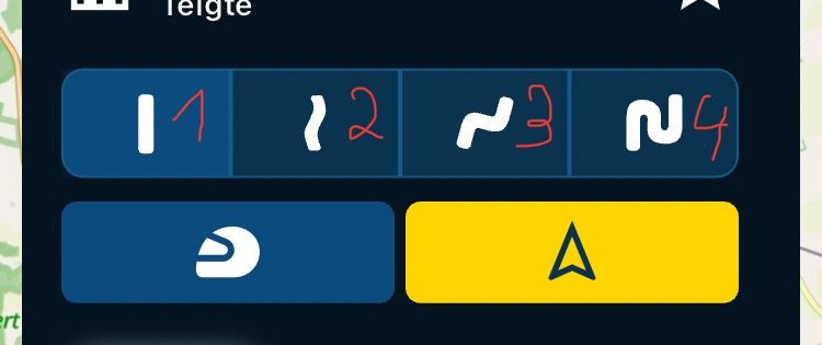
Hey Corjan, that's exactly what I've always missed personally, and the way it looks and apparently behaves, this also applies to this button 1./ 2. /3. / 4./ in the picture.
Thank you very much for that

-
@Marinus-van-Deudekom that’s where the fun part starts
(and why it has been quite some work).
Under the hood we use a lot of internal stops along the track to prevent you ever being sent straight to the endIf you have 2 viapoints (start & finish) you won’t ever be sent straight to the end. The only situation where this happens would be if you press and hold the end waypoint. You can always long press near a point along the track to resume from there
In short:
- route calculation always has a degree of freedom to calculate the route between individual waypoints. Due to traffic you can indeed get a different route than plannend.
- track navigation is identical to planned always as we follow the breadcrumb (disclaimer for offroad waypoints). The shown waypoints are there for visual information but do not influence the calculation. You can use them to skip a section / resume from a point. But even without displaying them that would be possible as you can long press anywhere near the line.
In both situations, viapoints are never skipped / missed
@Corjan-Meijerink Great work and I am really liking the options. One quick query for when navigating a route as a track, how would a road closure be handled? Would the app route around or would the rider have to take a detour and be directed back and, in this case, would the new directions be to beyond the known closure? Understand that the app can only deal with promulgated and known closures.
-
@Corjan-Meijerink Hi Corjan. As far as the MRA next app I'm with you all the way. My question was related to the external devices such as the Garmin Zumo's. How do those devices react on the track beein send by for instance the Drive app. Do the Zumo's see the track of the track with all of the fine extra's you've added.
@Marinus-van-Deudekom said in Updated beta! 4.3.4 (372):
My question was related to the external devices such as the Garmin Zumo's.
The change in navigating a route as a track is entirely implemented in the navigation app. Nothing changed in regard to a GPX export, and therefore nothing will change on your Zumo.
I am just an enthusiastic MRA user, and hope you will be one too!
Most motorcycle problems are caused by the nut that connects the handlebar to the saddle.
Check out RideSleepRepeat.eu, a biker community for sharing stays across Europe
-
@Marinus-van-Deudekom said in Updated beta! 4.3.4 (372):
My question was related to the external devices such as the Garmin Zumo's.
The change in navigating a route as a track is entirely implemented in the navigation app. Nothing changed in regard to a GPX export, and therefore nothing will change on your Zumo.
@Con-Hennekens That's indeed what I already thought so I will keep exporting the route to my Zumo and leave the track where it is
-
@Marinus-van-Deudekom that’s where the fun part starts
(and why it has been quite some work).
Under the hood we use a lot of internal stops along the track to prevent you ever being sent straight to the endIf you have 2 viapoints (start & finish) you won’t ever be sent straight to the end. The only situation where this happens would be if you press and hold the end waypoint. You can always long press near a point along the track to resume from there
In short:
- route calculation always has a degree of freedom to calculate the route between individual waypoints. Due to traffic you can indeed get a different route than plannend.
- track navigation is identical to planned always as we follow the breadcrumb (disclaimer for offroad waypoints). The shown waypoints are there for visual information but do not influence the calculation. You can use them to skip a section / resume from a point. But even without displaying them that would be possible as you can long press anywhere near the line.
In both situations, viapoints are never skipped / missed
@Corjan-Meijerink would be possible to have in track navigation more visible info if we are currently on the (planned) track or not? There is a line along the route but quite weakly visible. Maybe some color change od the arrow would be good idea, what do you think?
-
@Corjan-Meijerink
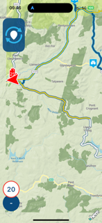
I planned a test ride with some of my favourite parts of mid wales in order to test version 4.3.4 - 272 properly on a long route with navigation of the route to be by track with only ‘vias’ showing - display of the navigation was through CarPlay.First issue was at the start as the app kept saying, “Reached Waypoint 40” (the end) and then ended the navigation! I had to ride the bike nearer towards Waypoint 1 and skip to Waypoint 2 for navigation of the track to resume correctly.
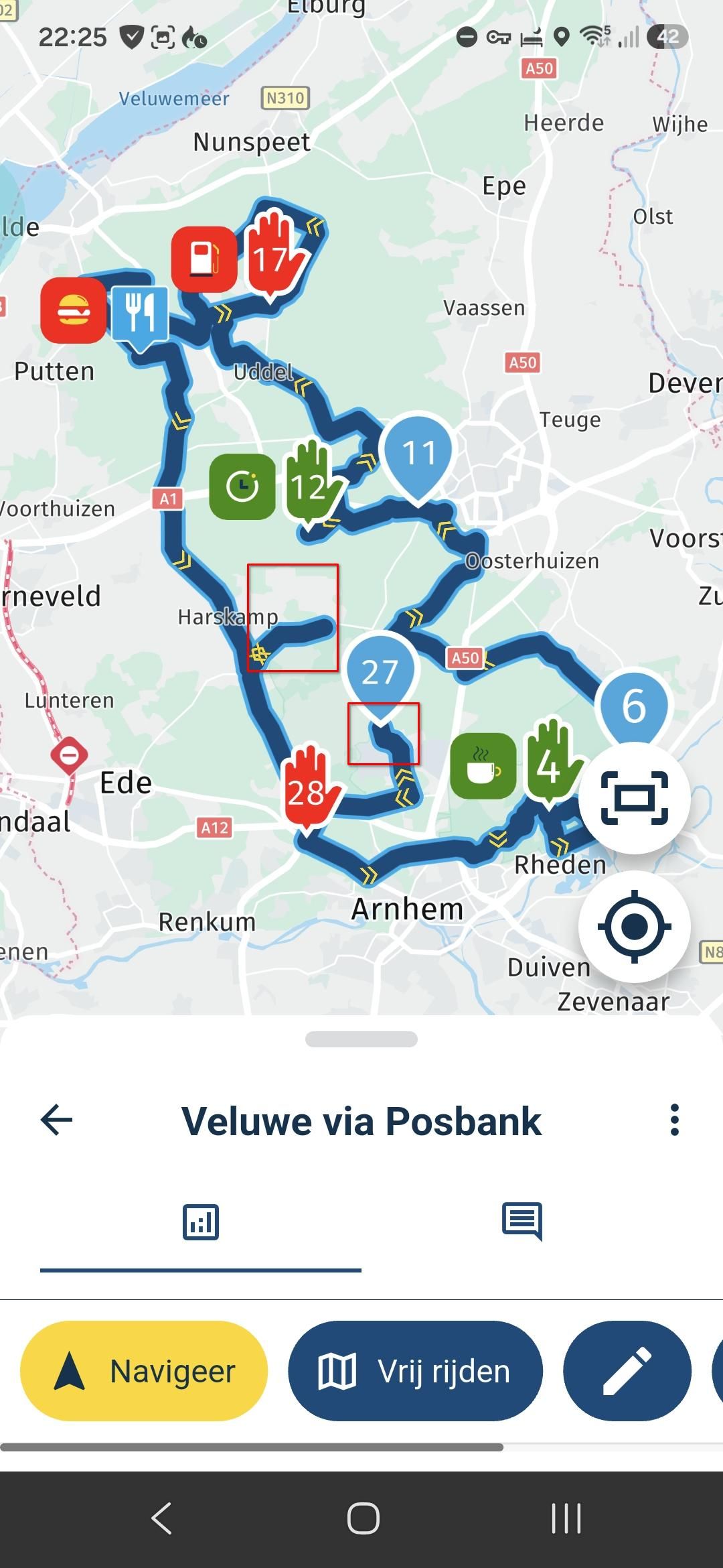
All good and no problems on the way to Waypoint 7 for a disconnect and coffee break. On reconnect and recommencing navigation after the ‘stop’, I followed the app to see where it would take me and I followed the instructions to Waypoint 25 - the next via on what appeared to be the fastest route and not the desired track. The routetrack should have taken on a southern loop (white):
Before stopping at Waypoint 25, I took a SE direction to backtrack the intended track to see what would happen. I was quickly presented with ‘recalculating’ as mobile signals for both data plans on my iPhone dropped but the app did not switch to ‘offline’ for the next 20 mins and the app appeared to have frozen when I stopped at Waypoint 25.
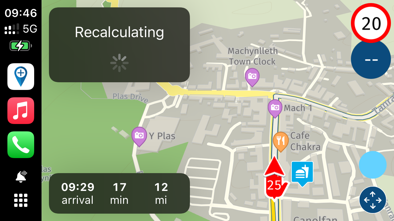
The app had to be closed on the iPhone to resume the track recording but the app would not recalculate the route even though I had signal with both sims. A switch to offline also did not resolve the issue despite having the correct maps loaded for offline use. A soft reset of the iPhone did not resolve the problem either.
Abandoning the route and setting a ‘course for home’ was met with repeated ‘no route found’ for offline and online. Manually selecting the destination from the map also did not help.
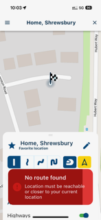
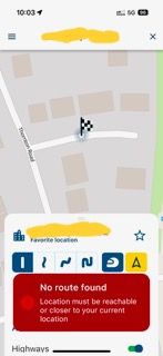
Not sure what was happening but I will raise a support ticket with app logs attached for you @Corjan-Meijerink .
Interesting trip.
Kind Regards. Help where I can.
Ducati Multistrada V4 Rally
iPhone 15 Pro
CHIGEE AIO-6 LTE
Google Pixel 6 Pro - mounted on SP Connect Plus
Ex Garmin XT2 and XT1 as well as Ex TomTom Rider User

Hello! It looks like you're interested in this conversation, but you don't have an account yet.
Getting fed up of having to scroll through the same posts each visit? When you register for an account, you'll always come back to exactly where you were before, and choose to be notified of new replies (either via email, or push notification). You'll also be able to save bookmarks and upvote posts to show your appreciation to other community members.
With your input, this post could be even better 💗
Register Login-
1663.0k
-
011106
-
21280
-
111282
-
06126
-
028709
-
0228
-
09553