Altitude
-
@Rob-Verhoeff Android

-
https://play.google.com/store/apps/details?id=com.amphebia.maps_altimeter&hl=gsw
I don´t think it is by country limited.
-
@Rob-Verhoeff This app is only for Android, IOs doesn't allow the floating icon.
-
Oh, sorry did not get this. Yes only Android.

Hardware
iPhone 12 pro (iOS 26.2.1)
iPad (7.Gen.) 18.7.3
Oukitel RT3 Pro (Andr. 14)
Wireless CarPlay mit (Elebest C650)
Wired CarPlay (SEAT Arona - 2021)
MRA Workshops in Deutsch sind hier zu finden -
@Jörgen Then again, that's clear and I was misled by your own footer in which I only have eyes for the iPhone
-
@Jörgen A bit late, but thanks. Being an iPhone-user, that app is not for me, but good to know something like that is available.

-
@Rob-Veerman Sorry this was in the Beta area.
Here the text.
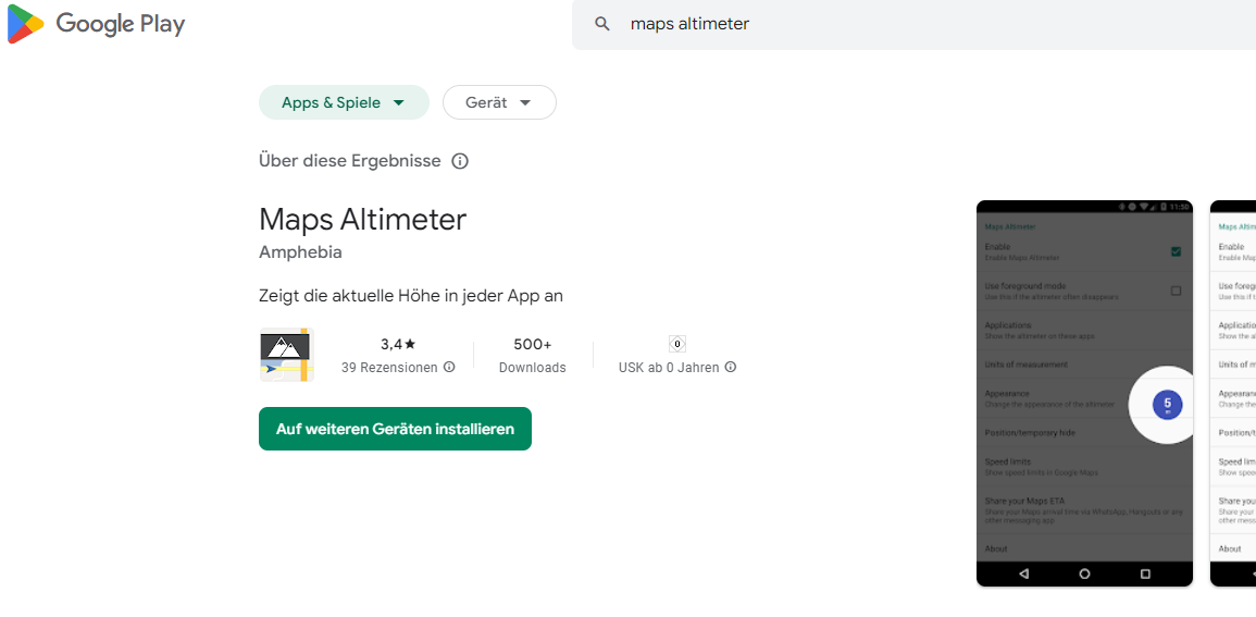
Hi, just found an App to Display the hight where you are. Adjustable in size, color, position etc. and displayed where you want.
The App is called Maps Altimeter.
@Jörgen
Very useful - thanks for sharing! -
Wow, too bad this is not possible within iOS. Hopefully the feature can be built into the app in the future

-
@Rob-Veerman Sorry this was in the Beta area.
Here the text.
Hi, just found an App to Display the hight where you are. Adjustable in size, color, position etc. and displayed where you want.
The App is called Maps Altimeter.@Jörgen Thanks for this suggestion. I have been using this app since I found this suggestion, but I will note that it has a limitation. Because it relies on Accessibility Services in Android, depending on your phone, permissions for Accessiblity can be reset every time you restart your phone.
On my Pixel 7 Pro running Android 16, Accessibility Services permissions are retained between restarts.
On my Nokia XR20 running Android 14, Accessibility Services permissions are reset after each restart. As the XR20 is my dedicated nav phone running MRA (it's a very good phone for this purpose), that means I have to change a bunch of permissions each time I start the phone.
A dedicated altitude field (toggleable on and off) would still be great to have in MRA.
-
@Jörgen Thanks for this suggestion. I have been using this app since I found this suggestion, but I will note that it has a limitation. Because it relies on Accessibility Services in Android, depending on your phone, permissions for Accessiblity can be reset every time you restart your phone.
On my Pixel 7 Pro running Android 16, Accessibility Services permissions are retained between restarts.
On my Nokia XR20 running Android 14, Accessibility Services permissions are reset after each restart. As the XR20 is my dedicated nav phone running MRA (it's a very good phone for this purpose), that means I have to change a bunch of permissions each time I start the phone.
A dedicated altitude field (toggleable on and off) would still be great to have in MRA.
@David-Emmett said in Altitude:
A dedicated altitude field (toggleable on and off) would still be great to have in MRA.
I totally agree.
Hardware
iPhone 12 pro (iOS 26.2.1)
iPad (7.Gen.) 18.7.3
Oukitel RT3 Pro (Andr. 14)
Wireless CarPlay mit (Elebest C650)
Wired CarPlay (SEAT Arona - 2021)
MRA Workshops in Deutsch sind hier zu finden -
@David-Emmett said in Altitude:
A dedicated altitude field (toggleable on and off) would still be great to have in MRA.
I totally agree.
Hi @Jörgen @David-Emmett just curious as to why altitude information is useful when navigating?
In an aircraft for sure, but on a motorcycle / car to me it seems like nice information but not much practical useBlackView BV7100, Android 12
Navigate "Routes as Tracks" in Offline mode with Offline Maps
No Wifi, no internet, no interruptions, works well -
Hi @Jörgen @David-Emmett just curious as to why altitude information is useful when navigating?
In an aircraft for sure, but on a motorcycle / car to me it seems like nice information but not much practical useHi, altitude information is for me like weather report, I like to know e.g. when I hit 1000m and where.
Everyone as he likes. -
Hi @Jörgen @David-Emmett just curious as to why altitude information is useful when navigating?
In an aircraft for sure, but on a motorcycle / car to me it seems like nice information but not much practical use@Brian-McG, it's just interesting information, not much more. Especially for people living in flatlands like the netherlands, like myself
-
Dutch guys don't need mountains........any I've met are really tall

-
As @Jörgen says, it's just useful and interesting information.
-
As @Jörgen says, it's just useful and interesting information.
Hi @David-Emmett I will concede it is interesting information but I still don't see how it is a useful piece of when navigating a motorcycle or car
I believe the altitude information may be contained in the recorded logs so it is available to inspect after the trip is completedBlackView BV7100, Android 12
Navigate "Routes as Tracks" in Offline mode with Offline Maps
No Wifi, no internet, no interruptions, works well -
It is in the logs. But where is the fun in digging through the logs? (I mean, there is fun in digging through the logs, but it's an entirely different activity).
I find it interesting, as I ride, to see speed, compass direction (roughly, I don't need bearing) and elevation. My interest is purely fleeting, at the moment of riding, and does not extend beyond "I wonder how high we are now?". I think I am not unique in having this casual curiosity.
This is not information that is absolutely necessary while navigating. It is merely additional information that some of us find interesting while riding. Hence my suggestion to make it a togglable field (in fact, adding a togglable field would also allow that field to be used for a selection of values, such as bearing in degrees, temperature, barometric pressure, GPS accuracy, battery %, or whatever. None of these are necessary, but I can imagine people being interested enough to want to see them.)
It was a feature of Garmin devices to show elevation. Though the worst bug I saw on the last Garmin I used was that elevation would be shown in metres up to 999m, then switch to kilometres. So it would go 997-998-999-1km and then you had to wait for the next 1000 metres of elevation before the display changed to 2km. Which sucked.
Anyway, there are workarounds for this, but they are a pain in the behind. It is just a nice to have feature, which is why I am posting it in this part of the forum
-
Hi @David-Emmett I will concede it is interesting information but I still don't see how it is a useful piece of when navigating a motorcycle or car
I believe the altitude information may be contained in the recorded logs so it is available to inspect after the trip is completed@Brian-McG, it is just fun to know at what altitude you are if you pass a high point. Why is your location considered essential, and your height not? Some people even have motorbike angle info on their display. How non-informative is that...? They just like to know the info
Hello! It looks like you're interested in this conversation, but you don't have an account yet.
Getting fed up of having to scroll through the same posts each visit? When you register for an account, you'll always come back to exactly where you were before, and choose to be notified of new replies (either via email, or push notification). You'll also be able to save bookmarks and upvote posts to show your appreciation to other community members.
With your input, this post could be even better 💗
Register Login-
012154
-
-436970
-
010184
-
1313234
-
0101.3k
-
08749
-
03105
-
0499