Add option for stripping shaping points in gpx export
-
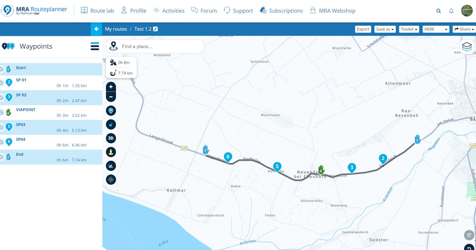
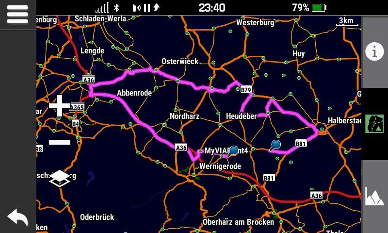
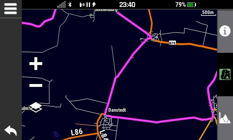
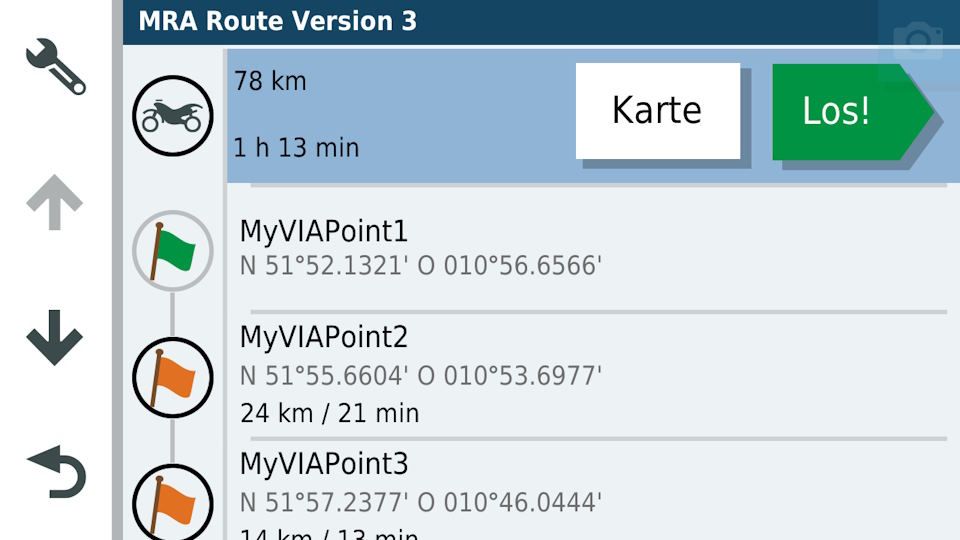
Let's asume, you have planed a simple route with a couple of VIA points and SHAPING points.
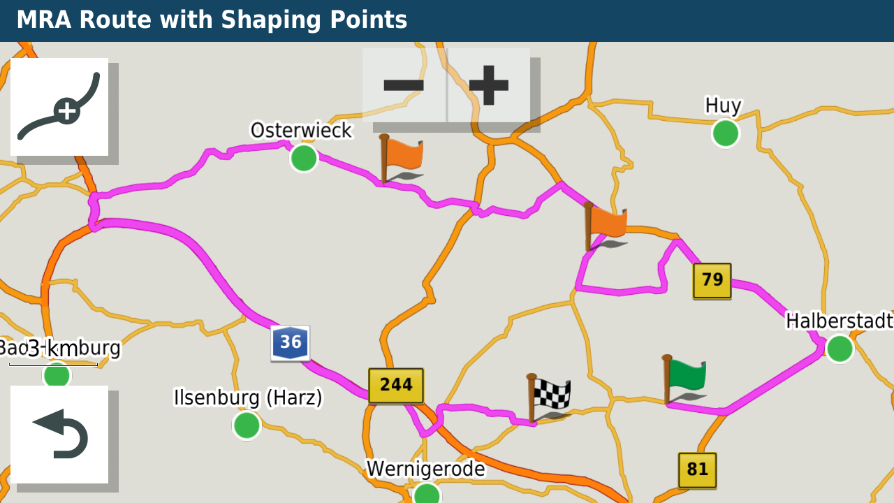
Garmin 'Automotive' devices, like Zumo XT and XT2 do understand shaping points. So you can have a high count of shaping points.
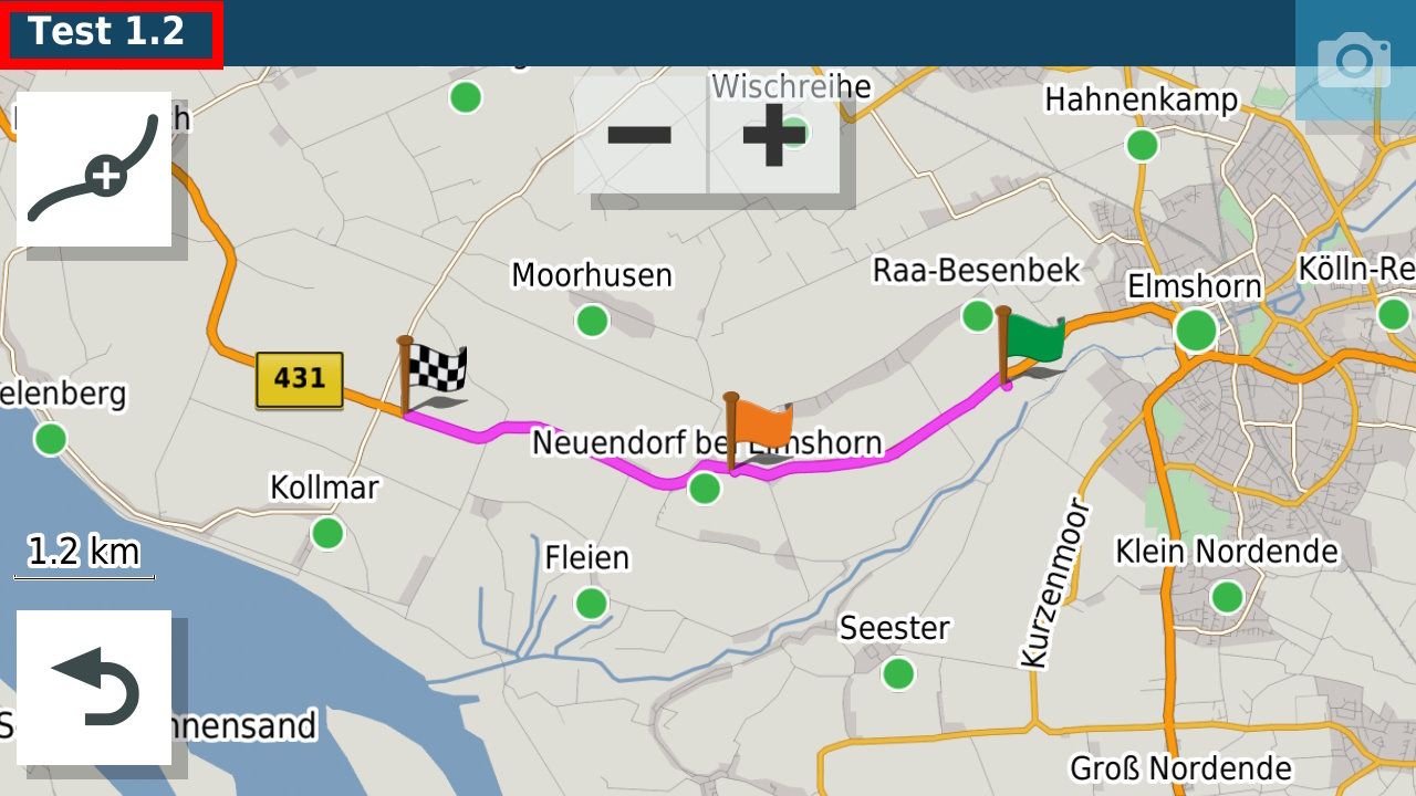
But if you have instead a Garmin 'Outdoor' device, like Garmin Montana 7xx, GPSMap 6x or GPSMap 276Cx, the device will behave different.
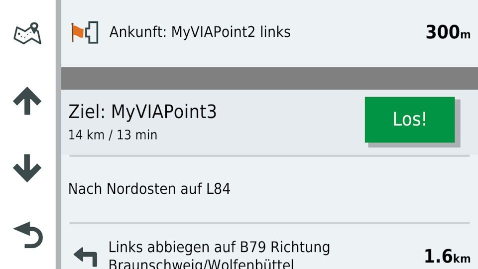
'Outdoor' devices from Garmin do not support shaping points. Instead, all shaping points are treated as VIA points. Additionally, there is a total limit of 50 via points including start and end.
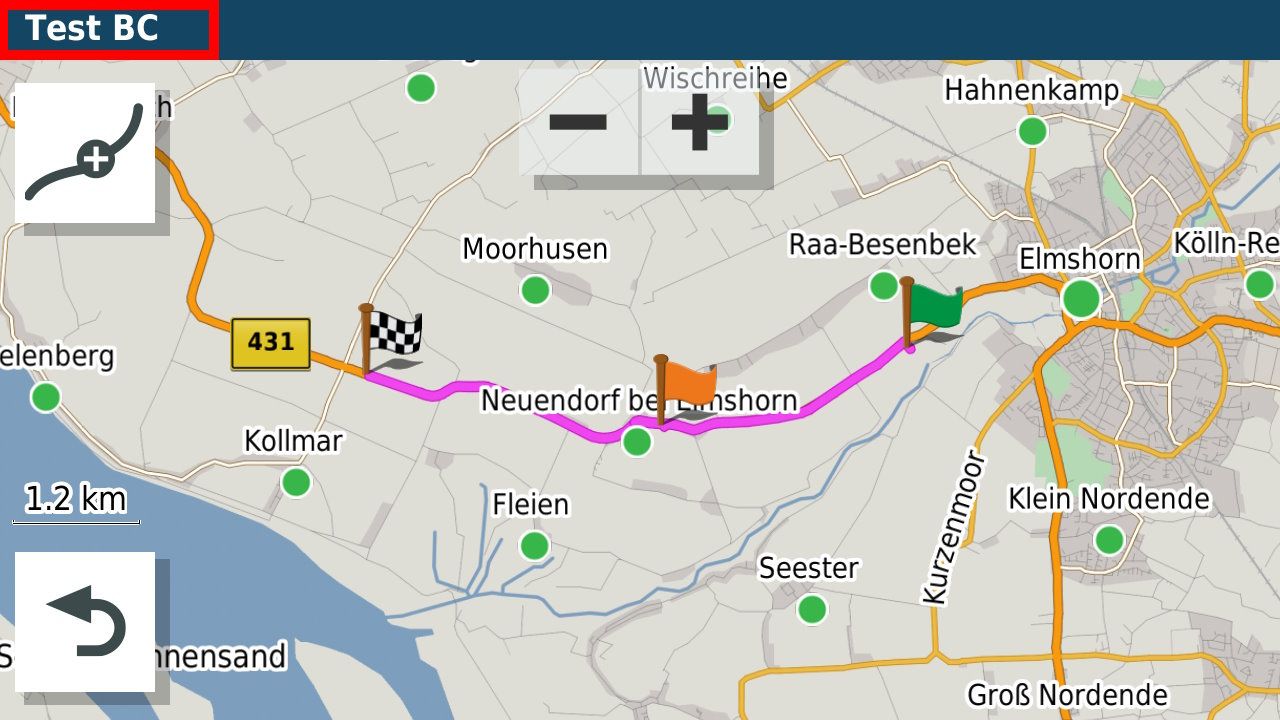
This leads to a problem, that you cannot plan routes with more than 50 points. But there is in Garmin BaseCamp a workaround for that. If you plan a route with many SHAPING points and only a few VIA points, you can enable in Garmin BaseCamp an option called "Strip shaping points during transfer to device". This means, if you transfer a route from BaseCamp to an outdoor device, all shaping points are removed. As the embedded RPE data is still contained (gpxx:rpt points), the route will be still the same as in basecamp and can use more than 50 points.
So I would like to see a new export option, something like " .gpx 1.2 (route, track, POI) without shaping points". This would add full support for Garmin outdoor devices.
-
@ConiKost
Hello,
in MRA (Gold Subsription) You you can reduce the number of way points to the limit you need in the tool kit option before transfer.
So if there are 90 waipoints und your max is 50 then go in Tool kit/
Tools/ Reduce and set the value e.g. to 49.MRA reduce the number now in a manner that your route is equal as before.
Nevertheless, check the route again best in higher magnification of the map that all remaining waypoints are as wished and that the route overall is ok and then take the transfer to your Garmin -
You can use the Track in outdoor devices, I also do that with my Garmin Edge 1030 bicycle navigation. Plan your route, then choose save as... gpx 1.1 (Track, POI)
-
@Peter-Schiefer While reducing the total waypoints to 50 would work, it is not really a good option. Since Outdoor devices consider all waypoints as VIA points, this still make it hard to distinguish, which are the real VIA points you wan to make a stop. The stripping option for shaping points in BaseCamp only leaves real VIA points in route, so you know, that this are the ones where you really want to stop or do something else. IMHO there are also situations, where 50 waypoints may not be enough.
-
While a track of course will just work fine, there are two major things missing:
- You won't get any turn-by-turn instructions with audio (Montana 7xx and GPSMap 276Cx support bluetooth audio just fine)
- A track does not contain any VIA points. You see only the track consisting of a 'breadcrump path'. So you can't see your planed VIA points.
Btw, I am not sure, if Garmin Edge can be considered as an Outdoor device, as older models even not supported any routes, but only Courses (Fit). So I am not sure here, how it compares to the other outdoor devices.
It would be very handy, if MRA could support stripping shaping points during export as Basecamp supports that during transfer to device.
Currently, I always need first to export the Route, import into BaseCamp and let do it's magic
-
@ConiKost said in Add option for stripping shaping points in gpx export:
As the embedded RPE data is still contained (gpxx:rpt points), the route will be still the same as in basecamp and can use more than 50 points.
Do I understand correctly that the shapingpoints are actually still in the GPX, but named differently? If that is the case, it would be an easy fix for when the website gets a major update. I think it is a valuable suggestion, if the "by foot" and "bicycle" profiles are taken seriously. I think GPX export optimized for outdoor devices would be really great! Especially if you consider that most people use OSM maps on their Garmin outdoor devices, which makes the use of the OSM maps in MRA webplanner very valuable!
Now I am wondering why I have never tried to export anything from MRA to my Garmin Oregon...
In the meantime I think this old but still working programm can be of value for you:
https://www.javawa.nl/rtwtool_en.html -
@ConiKost said in Add option for stripping shaping points in gpx export:
As the embedded RPE data is still contained (gpxx:rpt points), the route will be still the same as in basecamp and can use more than 50 points.
So I would like to see a new export option, something like " .gpx 1.2 (route, track, POI) without shaping points".I understand the issue - but an MRA export as GPX 1.2 does exactly what you need: the viapoints are retained but the shaping points are removed and replaced by gpxx:rpt.
This should correspond to what happens when transferring from BC with the ‘strip SPs’ option.
If you transfer the same route to your Garmin outdoor device using both methods, how do the results differ?
-
This post is deleted! -
@ConiKost said in Add option for stripping shaping points in gpx export:
@Peter-Schiefer While reducing the total waypoints to 50 would work, it is not really a good option. Since Outdoor devices consider all waypoints as VIA points, this still make it hard to distinguish, which are the real VIA points you wan to make a stop. The stripping option for shaping points in BaseCamp only leaves real VIA points in route, so you know, that this are the ones where you really want to stop or do something else. IMHO there are also situations, where 50 waypoints may not be enough.
Coni Kost
I believe, what a not seldom issue is with the different Garmin Devices that user think the device is a one fit all device.
But an outdoor navi like the GpX serie is for outdoor activities were the moving speed in average is usually at 5 to 50 kilometers per hour. So the maximum distance for a route per day is somewhat between 200 to 400 kilometers. Who need on such a distance more than 50 viapoints for a stop like coffebeak, fillingstation, interesting point and finally route cotrol.the 700i allows to intall the Eu road map for long distance and here again when you need to cover more than kilometer on a daytrip you need to drive over highways or other long distance class roads were you not so often need to change the direction and can reduce the number of WP.
I use Navigation now close to 20 years for trip distances between 100 km (short few our daytrip) to 250 km on windy roads up to 800 km for a day ride to a far destination like a holiday house. Never used more than 50 Wp to adjust those tours like I want to ride.
-
@Con-Hennekens said in Add option for stripping shaping points in gpx export:
In the meantime I think this old but still working programm can be of value for you:
https://www.javawa.nl/rtwtool_en.htmlLet me add two other tools that may help.
and
-
I don't think that any of the tools mentioned will help. It's not about format conversion, but about changing the content (stripping SPs).
I have created a route with both MRA-Export 1.2 and BC-Transfer (with ‘Strip-SP-Option’) and the result is almost identical (the BC-version additionally contains gpxx:subclasses, but that should be irrelevant).
On my Zumo XT both versions behave the same. It may be different on a Garmin outdoor device, but I doubt it.
-
@Martin-Wilcke, My suggestion was more targetted towards the mentioned Garmin Edge. It seems that JaVaWa is able to turn GPXs into courses for the Edge. But besides that, Javawa is able to "unflag" soft waypoints, which sounds very much like the stripping you explained. But I am not really educated about that.
I will try to import a GPX 1.2 into my Oregon later, see what happens.
-
Well, so many answers here. Thank you very much! I will do some tests and report back.
-
I'm looking forward to the result!
Here I've stored the two route versions I created - if you like, you can also load them onto your oregon and see how they differ...
-
@Peter-Schiefer excercise caution doing this, as if you reduce it by too many points, that actual route planned will change.
For me, to help avoid that from happening, I will experiment reducing the points until the route changes, then undo that change to get the route as planned, back. From there, if I feel there are still too many points, I will start to delete them individually. Again, caution needs to be used as at a certain point, the route will change if not careful.
Good luck!
-
@GT-JWR said in Add option for stripping shaping points in gpx export:
@Peter-Schiefer excercise caution doing this, as if you reduce it by too many points, that actual route planned will change.
For me, to help avoid that from happening, I will experiment reducing the points until the route changes, then undo that change to get the route as planned, back. From there, if I feel there are still too many points, I will start to delete them individually. Again, caution needs to be used as at a certain point, the route will change if not careful.
Good luck!
GT-JWR
thank you for the wishes „Good Luck“,
but, up to now I never used „automatic wp-reduction“.
If I copy a route proposal, e g. from a bike magazine, I copy the track as sample-overlay in MRA in build my own route. In most cases I have a different startpoint and other POIs or route preferences -
Hi everybody,
interesting topic, although it doesn´t concern my use case. Hope you´ll find a solution or at least a workaround.
Just to give an example of scale and "sustainble" use of routing points: this route is 13 days and approx. 7200 km. It uses 192 waypoints. The individual day trips have around 25 to 30 waypoints and average ca. 550 km.
My "dirty solution" for the problem with the old Garmin would be simple: I´d build a loop. Let´s say your planning is a stop at waypoint 8, but you have no waypoints. Why not set waypoint 9 before the real stop? If you reached your planned stop, the Garmin would tell you to turn back. Not suitable for leading groups, I guess.^^
Regards from Austria,
André -
All right, I did now run some tests and have so say, that I was completly wrong in my mind. The "GPX 1.2" export does work indeed. No shaping points are exported, so a route with more than 50 shaping points just works fine. The route is also correctly being shown.
But: There seems to be an issue with Outdoor devices. All VIA points are missing and not shown. Only Start and End Point is shown, but all Via Points between are gone. This seems only be an export issue, as the VIA points are corrently shown on the MRA web route planer. I can also see those VIA points in the GPX 1.2 file, but the Montana seems just not detect them. I can reproduce that with my Montana.
This does not happen, when using the same exported route from BaseCamp.
I am attaching the same route
- Transfer with BaseCamp including Shaping Points
- Transfer with BaseCamp without Shaping Points
- Transfer GPX 1.2 from MRA to Montana
@Hans-van-de-Ven-MR-MRA This would be an investigation worth, because if that could be fixed, we would have full support for Outdoor devices like Montana.
The routes can be found here:
MRA Route GPX 1.2
BC Route with Shaping Points
BC Route without Shaping Points -
@Martin-Wilcke I have the same issue with your example routes. "Test BC.gpx" works correctly and shows the VIA point in the middle. With "Test 1.2.gpx", the VIA point in the middle is missing and not shown.
-
@ConiKost said in Add option for stripping shaping points in gpx export:
"Test BC.gpx" works correctly and shows the VIA point in the middle. With "Test 1.2.gpx", the VIA point in the middle is missing and not show
That's strange and I didn't expect it.
I have looked at the files - the differences are rather insignificant. But obviously the Montana behaves differently, because the MRA 1.2 is displayed correctly on the XT:
I have made two manual changes to the MRA 1.2 to find out the secret. Can you please load the ‘MRA Route version 2’ saved here
https://hidrive.ionos.com/share/pquvtok.yw
onto your Montana and check whether one of the two Viapoints is displayed?