MRA and the BMW Connected App
-
@Wim-Dekker said in MRA and the BMW Connected App:
@Boonants-Chris De routes die ik zelf maak hebben minder dan 50 waypoints. Dit is ook het geval met routes die ik overneem. Ik denk dat jij routepunten bedoeld i.p.v. waypoints. Het probleem met de info die je toevoegt heb ik ook. Wat ik soms wel doe is om in de BMW-app favorieten aanmaak op plaatsen die ik niet wil missen. Deze komen wel in de BMW-app.
Ik probeer dit even te herleiden naar de functionaliteit van de MRA Planner. Die kent Via- of Vormingspunten.
De BMW Connected App kent dat onderscheid niet. Als je vanuit MRA exporteert krijg je het aantal "Steunpunten" dat overeenkomt met het aantal Via- en Vormingspunten samen.@Boonants-Chris The routes I create myself have fewer than 50 waypoints. This is also the case with routes that I take over. I think you mean waypoints instead of waypoints. I also have the problem with the info you added. What I sometimes do is create favorites in the BMW app at places that I don't want to miss. These will be included in the BMW app.
I am trying to trace this back to the functionality of the MRA Planner. It has Via or Shaping Points.
The BMW Connected App does not make that distinction. If you export from MRA you will receive the number of "Waypoints" that corresponds to the number of Via and Shaping Points together.@Jack-van-Tilburg Thank you for translating the Dutch and I'm not sure if there's still questions here?
To clarify. both Via and Shaping Points in MRA are seen as Waypoints in the Connected app and currently the limit is 50 waypoints. Many see that as insufficient and I'm not wanting to start a debate, but if you plan carefully, in my experience 50 is plenty for a day's route. This is because in general the route with be 'natural' (A to B). It's only when the route is 'unnatural' (I must go this way) that you need a shaping point to force the move. I normally plot my route manually to do what I wish and then (Gold membership needed), expand the number of points to say 48 or similar. I travelled 10,000km in June in 30 days to Nordkapp and back through Finland, etc. using this functionality and it was pretty well perfect.
The only downside is you get an announcement at each connected app waypoint, which in the main are only shaping points from MRA. "In 800 metres you will reach your stop". That is in one way confusing/annoying, but in another way reassuring that you're 'on route'
As I say, not sure there were further questions there but since posting my process I have used extensively with great success.
NOTE: It would be great if you could change the announcement to be something typed in MRA but we'll need to wait for planets to align.
-
@Jack-van-Tilburg Thank you for translating the Dutch and I'm not sure if there's still questions here?
To clarify. both Via and Shaping Points in MRA are seen as Waypoints in the Connected app and currently the limit is 50 waypoints. Many see that as insufficient and I'm not wanting to start a debate, but if you plan carefully, in my experience 50 is plenty for a day's route. This is because in general the route with be 'natural' (A to B). It's only when the route is 'unnatural' (I must go this way) that you need a shaping point to force the move. I normally plot my route manually to do what I wish and then (Gold membership needed), expand the number of points to say 48 or similar. I travelled 10,000km in June in 30 days to Nordkapp and back through Finland, etc. using this functionality and it was pretty well perfect.
The only downside is you get an announcement at each connected app waypoint, which in the main are only shaping points from MRA. "In 800 metres you will reach your stop". That is in one way confusing/annoying, but in another way reassuring that you're 'on route'
As I say, not sure there were further questions there but since posting my process I have used extensively with great success.
NOTE: It would be great if you could change the announcement to be something typed in MRA but we'll need to wait for planets to align.
@Nick-Hodge
The number of allowed waypoints in BMW CA may indeed be too short in our country (NL).
For example, I have a route of 152 km in the middle of the Netherlands with 57 waypoints. The route there goes over small back roads (as you say "must go this way").
At the same time I am also planning a trip to the North Cape and do not need more than 25 waypoints for the outward route via Sweden.NOTE: It would be great if you could change the announcement to be something typed in MRA but we'll need to wait for planets to align.
That must be more due to the developers of TomTom than to BMW, I think?
-
@Nick-Hodge
The number of allowed waypoints in BMW CA may indeed be too short in our country (NL).
For example, I have a route of 152 km in the middle of the Netherlands with 57 waypoints. The route there goes over small back roads (as you say "must go this way").
At the same time I am also planning a trip to the North Cape and do not need more than 25 waypoints for the outward route via Sweden.NOTE: It would be great if you could change the announcement to be something typed in MRA but we'll need to wait for planets to align.
That must be more due to the developers of TomTom than to BMW, I think?
@Jack-van-Tilburg Certainly the further up Norway you get the less roads you have choice of
")
-
@Jack-van-Tilburg Certainly the further up Norway you get the less roads you have choice of
I think by now the Connected app or Connected Navigator can use more than 50 points. Or am I missing something?
-
I think by now the Connected app or Connected Navigator can use more than 50 points. Or am I missing something?
@Michiel-14
The app can not use more than 50.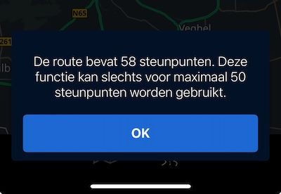
-
I think by now the Connected app or Connected Navigator can use more than 50 points. Or am I missing something?
@Michiel-14 if you plot in MRA (or any other app) and set more than 50 ‘shaping points’ it will not load how I set in my post
-
@Michiel-14 if you plot in MRA (or any other app) and set more than 50 ‘shaping points’ it will not load how I set in my post
@Nick-Hodge @Jack-van-Tilburg Ok, dank voor de info!
-
@Nick-Hodge @Jack-van-Tilburg Ok, dank voor de info!
Save it as .itn and place the file in the route folder on the CRN and import the route
-
Or use the track. If the TomTom engine in the Connected Ride App works the same as in TomTom's own software. You do not need any skipping functionality.
The engine will always guide you back to the original route.The biggest drawback of riding with a track is, not able to use waypoints. That can be a dealbreaker sometimes. You maybe can use POI as an alternative for waypoints
But the stability of the TomTom engine on track support is very hard to break. -
@Nick-Hodge this is of great help to others! Thanks
")
Exporting to other apps like you’ve shown is really one of the great features we developed in the app.@Corjan-Meijerink
Very helpful , can you confirm that the file should be saved as a GPX 1.1 file with tracks and waypoints being imported.I am also using a BMW connected TFT screen.
Thanks
-
@Corjan-Meijerink
Very helpful , can you confirm that the file should be saved as a GPX 1.1 file with tracks and waypoints being imported.I am also using a BMW connected TFT screen.
Thanks
@Shahed-Rafique-0 This is a bit late to be replying, but yes, save as a GPX1.1 (Route and Track)
-
 undefined King 06 referenced this topic on
-
nick, I'm planning a trip as you've described for next year. I would be interested to see the timings you allowed for each day, anything you would have changed, etc.
Thanks.
-
nick, I'm planning a trip as you've described for next year. I would be interested to see the timings you allowed for each day, anything you would have changed, etc.
Thanks.
@steve-poole I have all the maps and the actual ridden tracks. It was a phenomenal ride over 28 days up Norway (via Holland, Germany, Denmark and Sweden, although these were just transit days). Norway during June for us was spectacular. Down Finland through Estonia, Latvia, Lithuania, Czechia, Poland, Belgium and France. 10,000km with two days off and a couple of short days. Email me for more info (nick at nickhodge dot co dot uk)
-
@steve-poole I have all the maps and the actual ridden tracks. It was a phenomenal ride over 28 days up Norway (via Holland, Germany, Denmark and Sweden, although these were just transit days). Norway during June for us was spectacular. Down Finland through Estonia, Latvia, Lithuania, Czechia, Poland, Belgium and France. 10,000km with two days off and a couple of short days. Email me for more info (nick at nickhodge dot co dot uk)
@Nick-Hodge thanks Nick. I'll send you an email in the morning.
-
@steve-poole I have all the maps and the actual ridden tracks. It was a phenomenal ride over 28 days up Norway (via Holland, Germany, Denmark and Sweden, although these were just transit days). Norway during June for us was spectacular. Down Finland through Estonia, Latvia, Lithuania, Czechia, Poland, Belgium and France. 10,000km with two days off and a couple of short days. Email me for more info (nick at nickhodge dot co dot uk)
@Nick-Hodge mail sent with my contact details. Thank you.
-
 undefined Cleo referenced this topic on
-
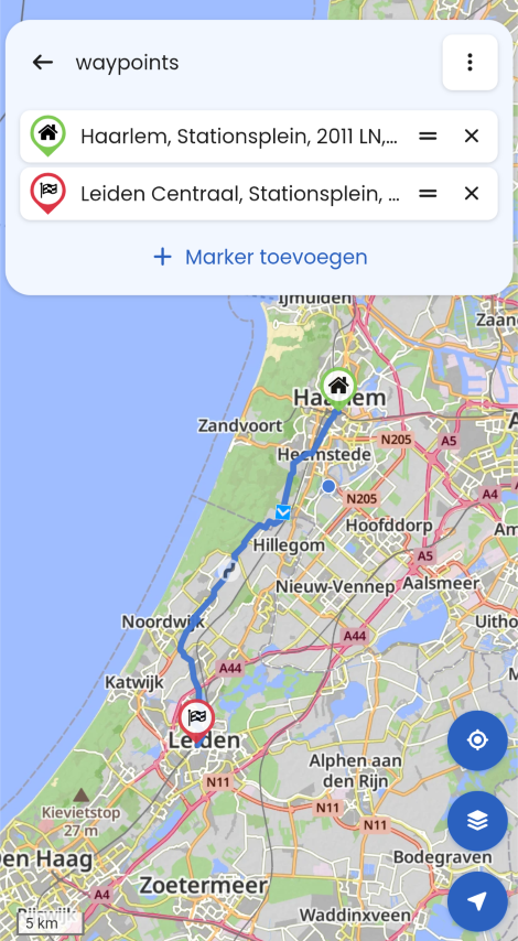
Been enjoying plotting routes for a trip from UK to Nordkapp and back home down Finland et al starting on 29th May, using my new Lifetime Gold Membership (Caveat: BMW Connected App uses TomTom maps, so you need Gold and to plot using those maps). I have a K1600GT where the new 10.25in TFT has 'map view' and the Connected App is nearly 100% functional with it, unlike with my last 3 GS(A)s.
I am also looking forward to MRA-app Next with Navigation for other vehicles, but currently I love being able to use a quality online tool to plot my routes accurately. The beauty of this too is the new simplicity of using the MRA phone app (iPhone in my case) to move the routes WITH WAY/VIA POINTS into the connected app. These waypoints are not exactly as they are set up in MRA. (They seem to take the 'default' TomTom name for the location of your plotted waypoint in MRA not any custom name you give it. NOTE: This has a further advantage when using the 'expand' function in MRA as the MRA default-named 'Waypoint' gets converted to something more meaningful. FURTHER NOTE: There is a fifty waypoint limit in the Connected App).
Below is the process after plotting the route, all on my phone using the two apps.
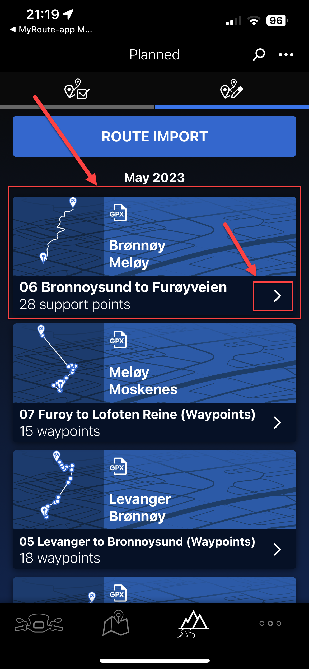
- Open the MRA app and going through Route Lab>Routes, open your route.
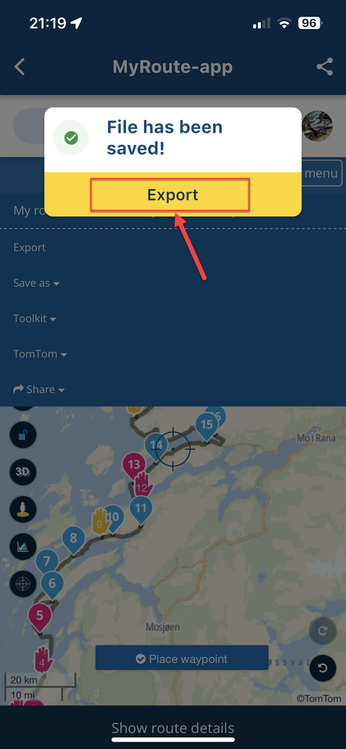
- Hit the 'Page menu' and select '.gpx 1.1 (route, track, POI)'
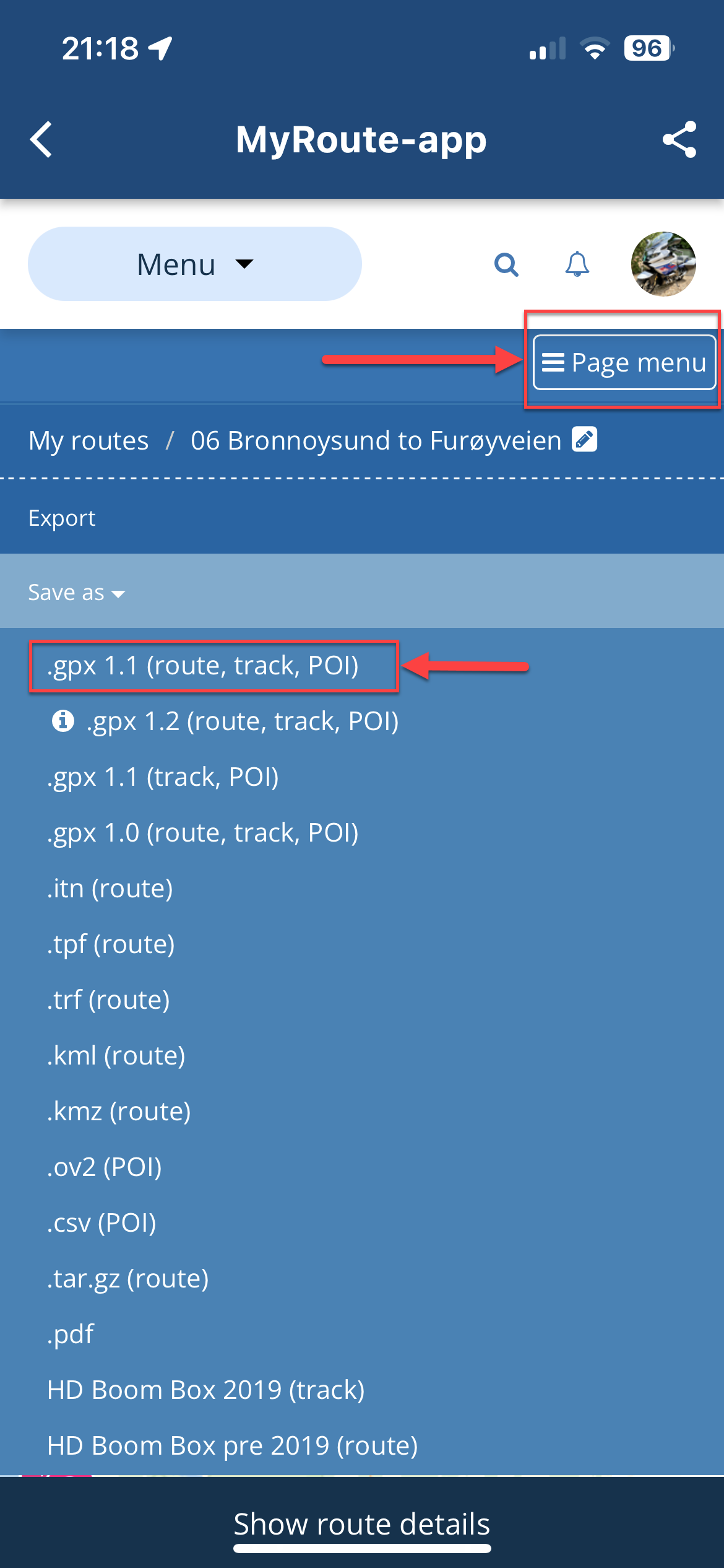
- This will prepare the file for export and present a dialog. Hit 'Export'
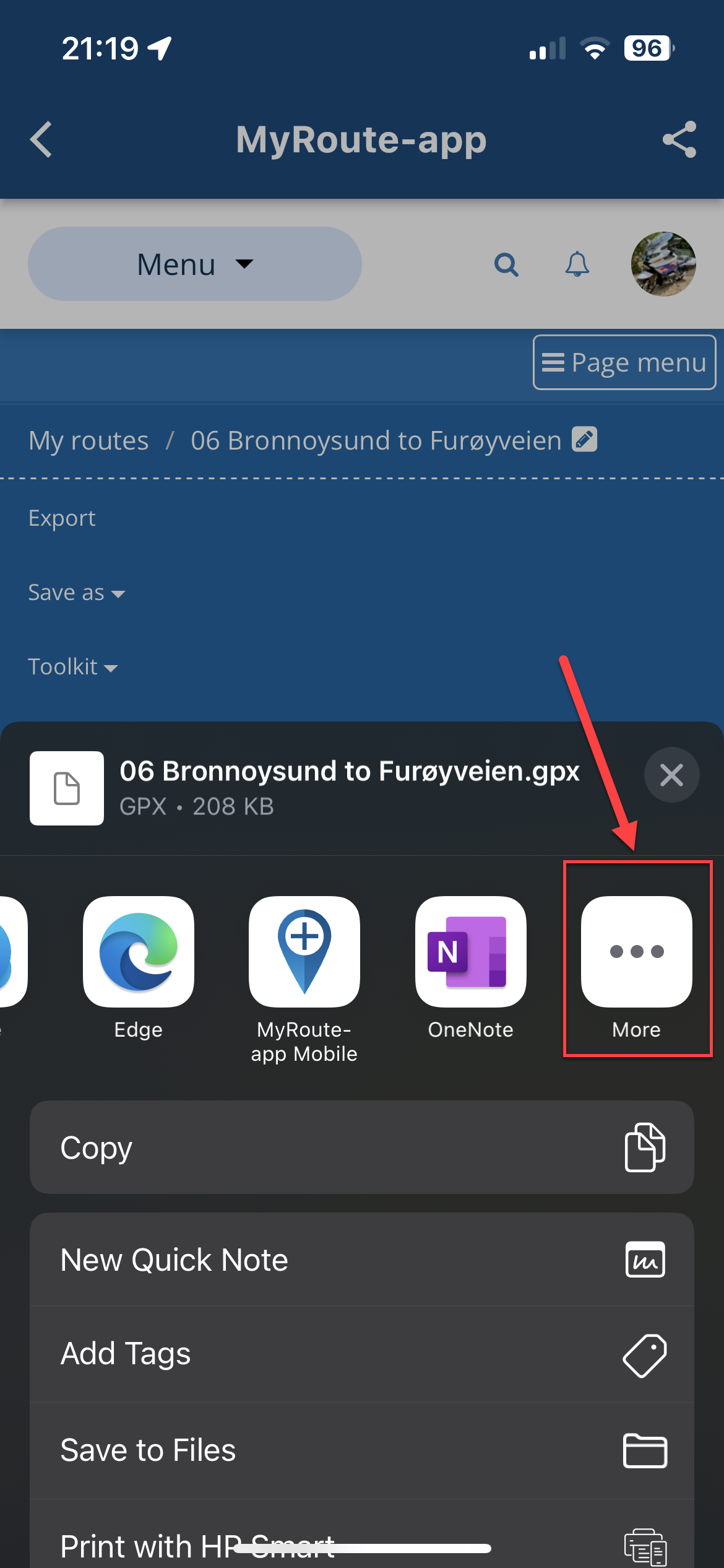
- This will display the 'options list'. Scroll fully right and select 'More'
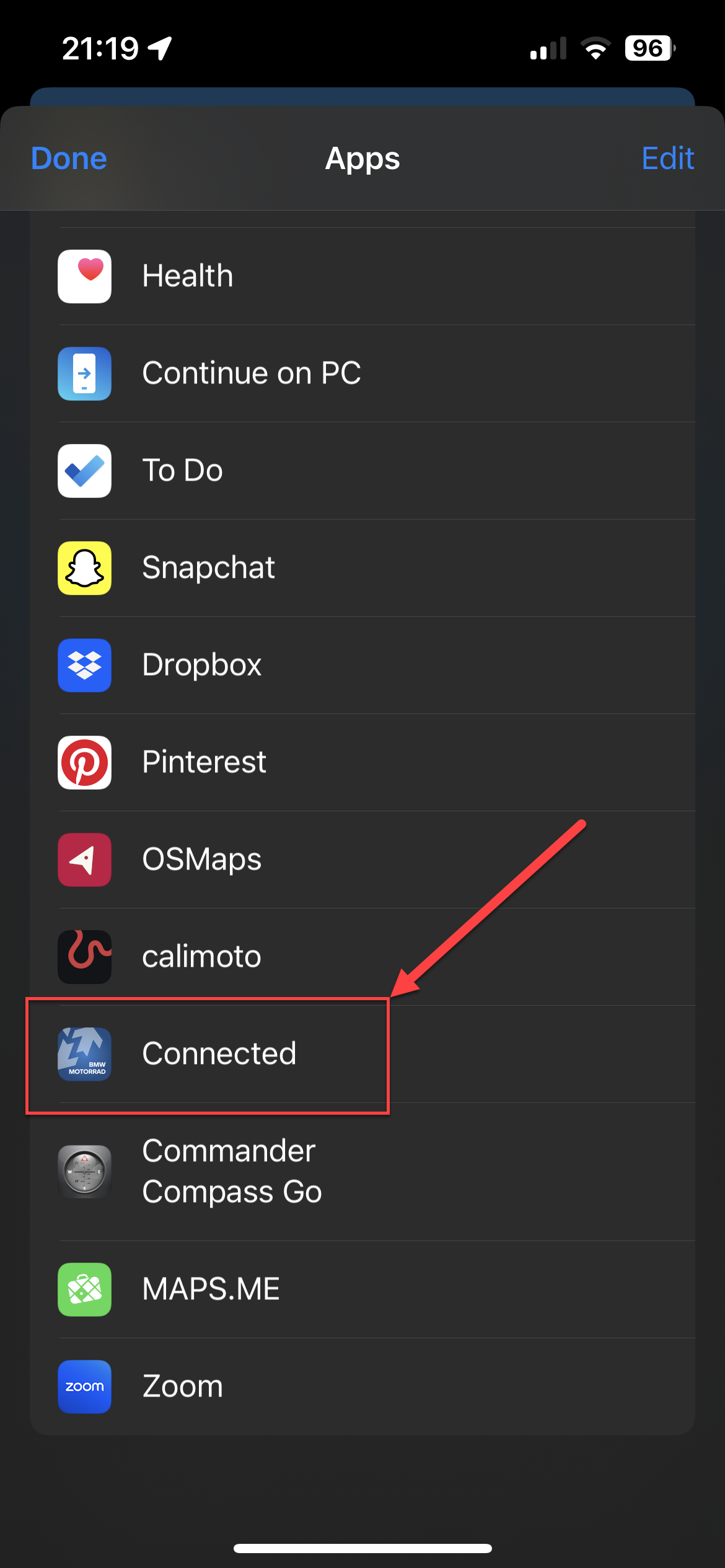
- From the list, navigate to 'Connected' and click that.
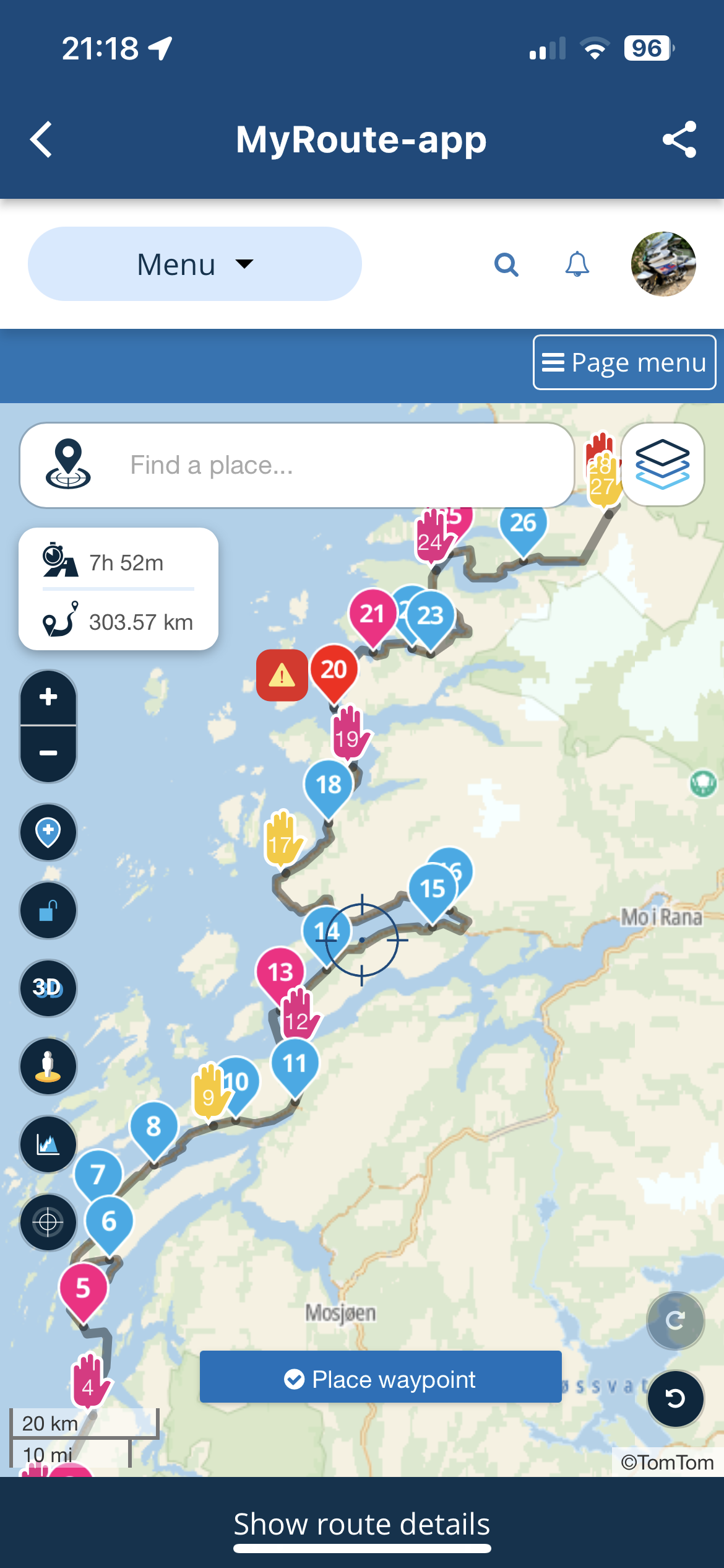
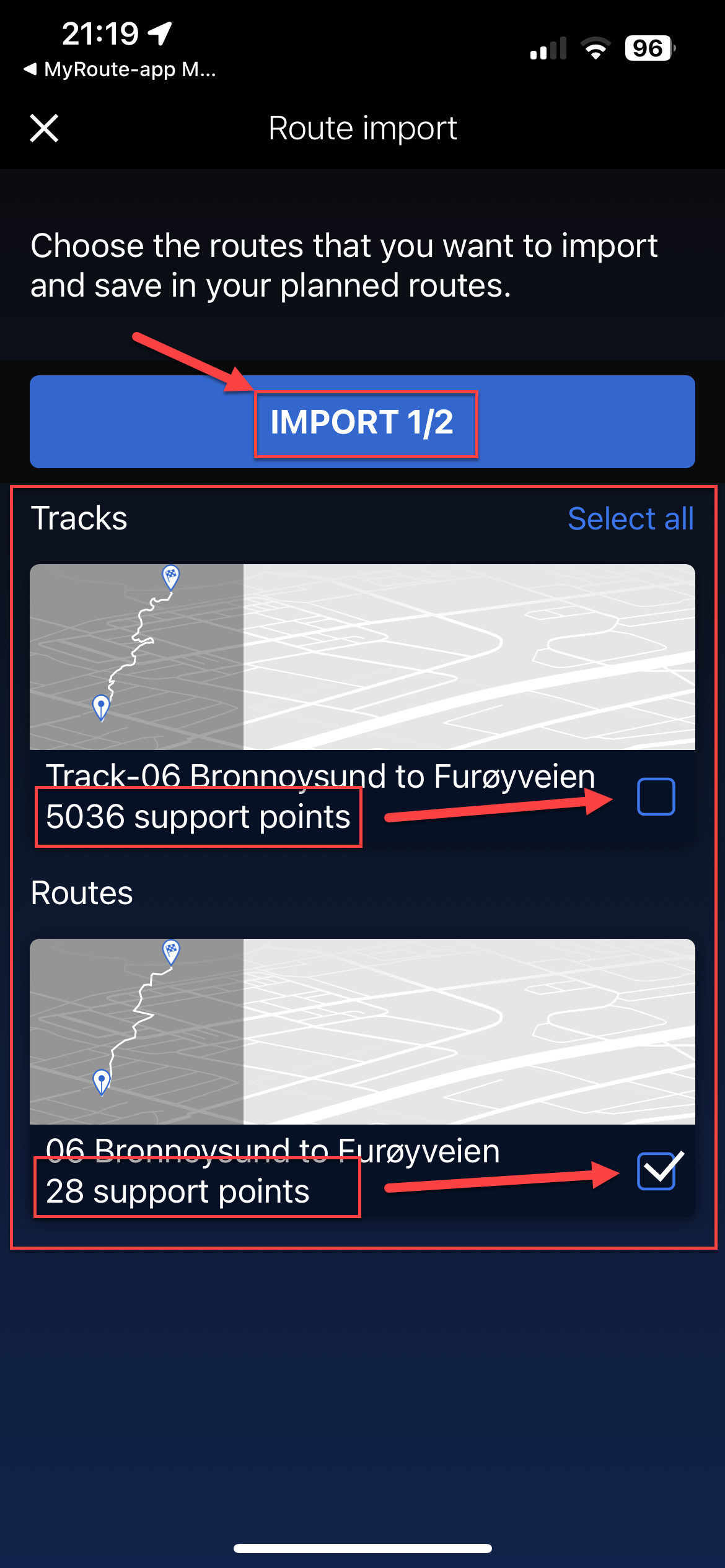
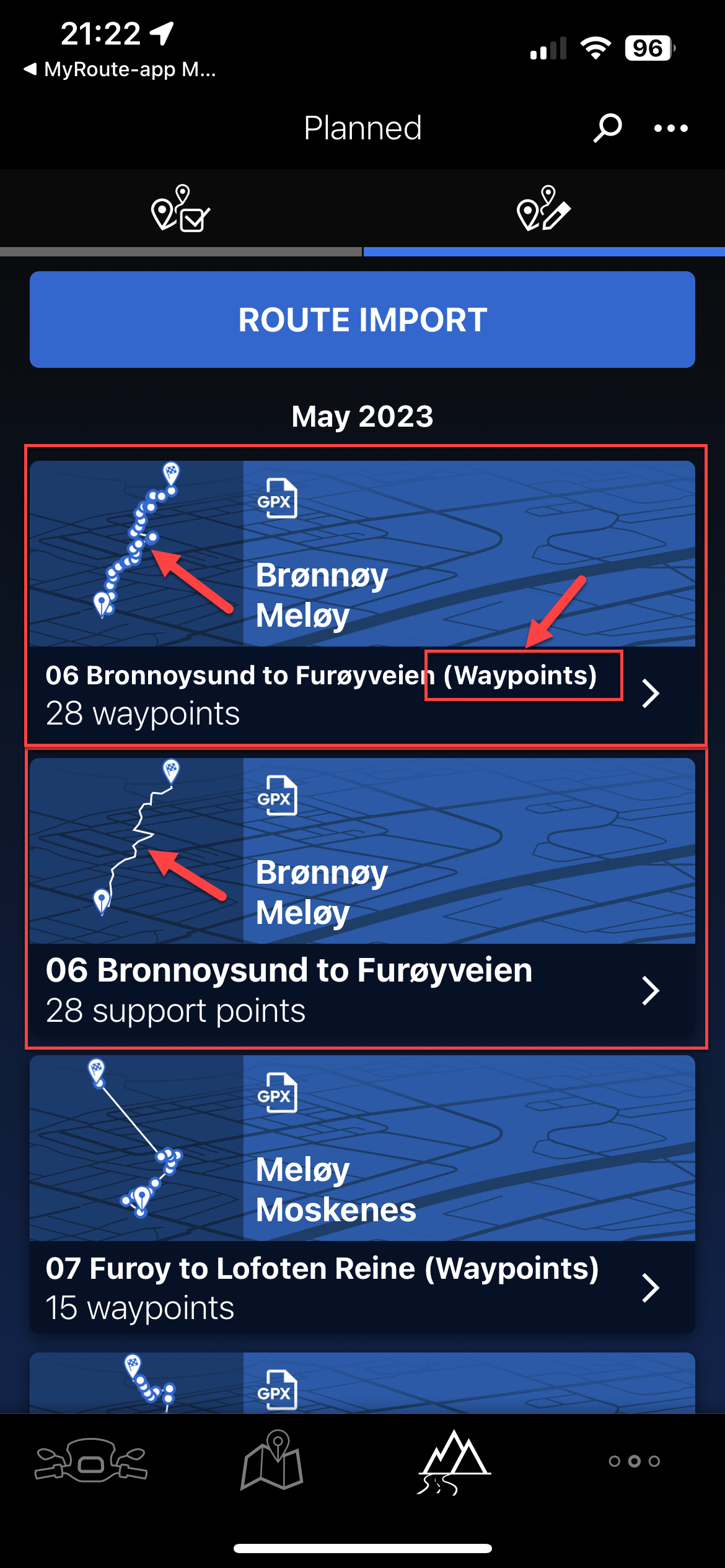
- This will load the two components of the data (Route and Track). You may get a third if you added something from the POI list in MRA. You can ignore this third one entirely. You will notice the track has many points (normally thousands), the route will have the same number of 'Support' points as the Way and Via points in your MRA route. Uncheck the track (and POI if you have a third), so you just have the 'Route' selected. Click 'Import'
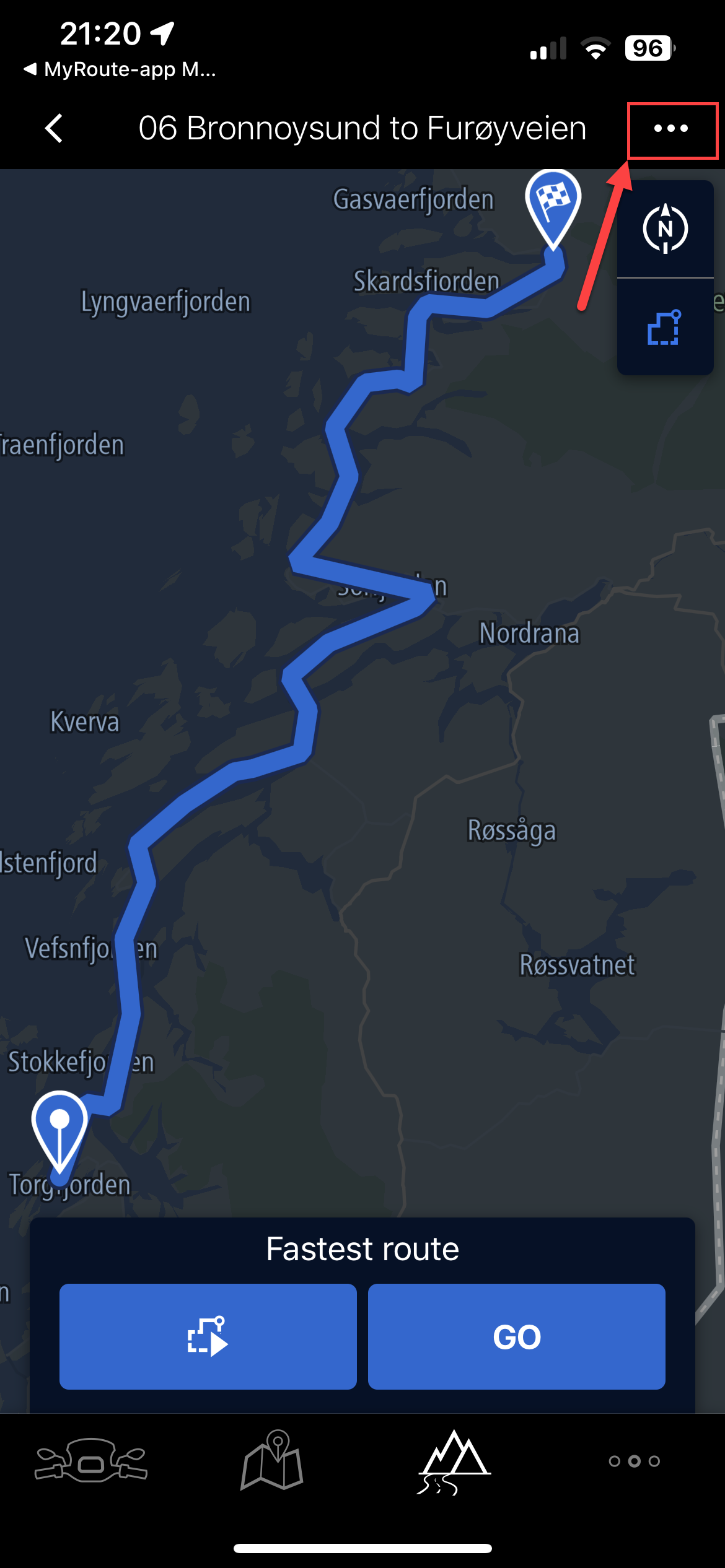
- This will import the route into the BMW Connected App as below, still showing 'Support Points'. Click on the route to open it.
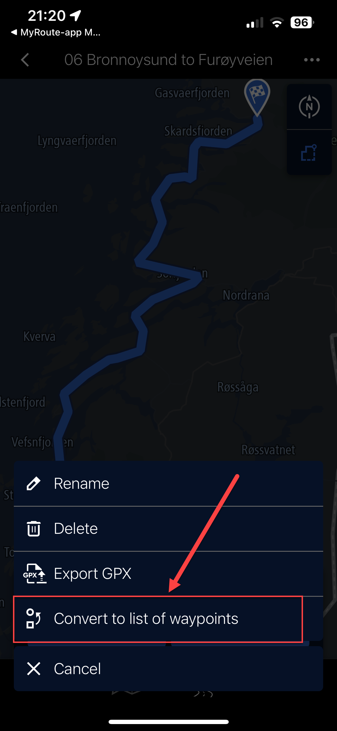
- This will show you a rough representation of the route but no waypoints will be shown. Hit the three buttons top right of this screen (...)
- Select 'Convert to list of waypoints'
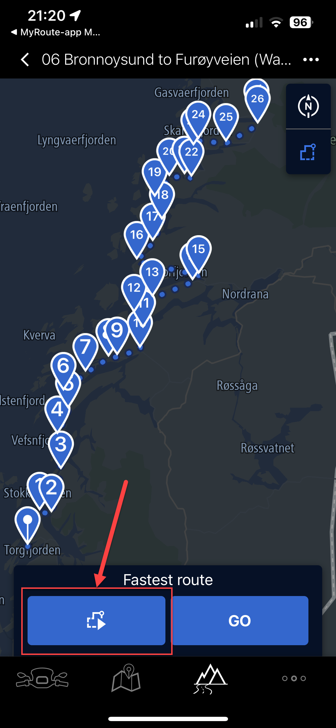
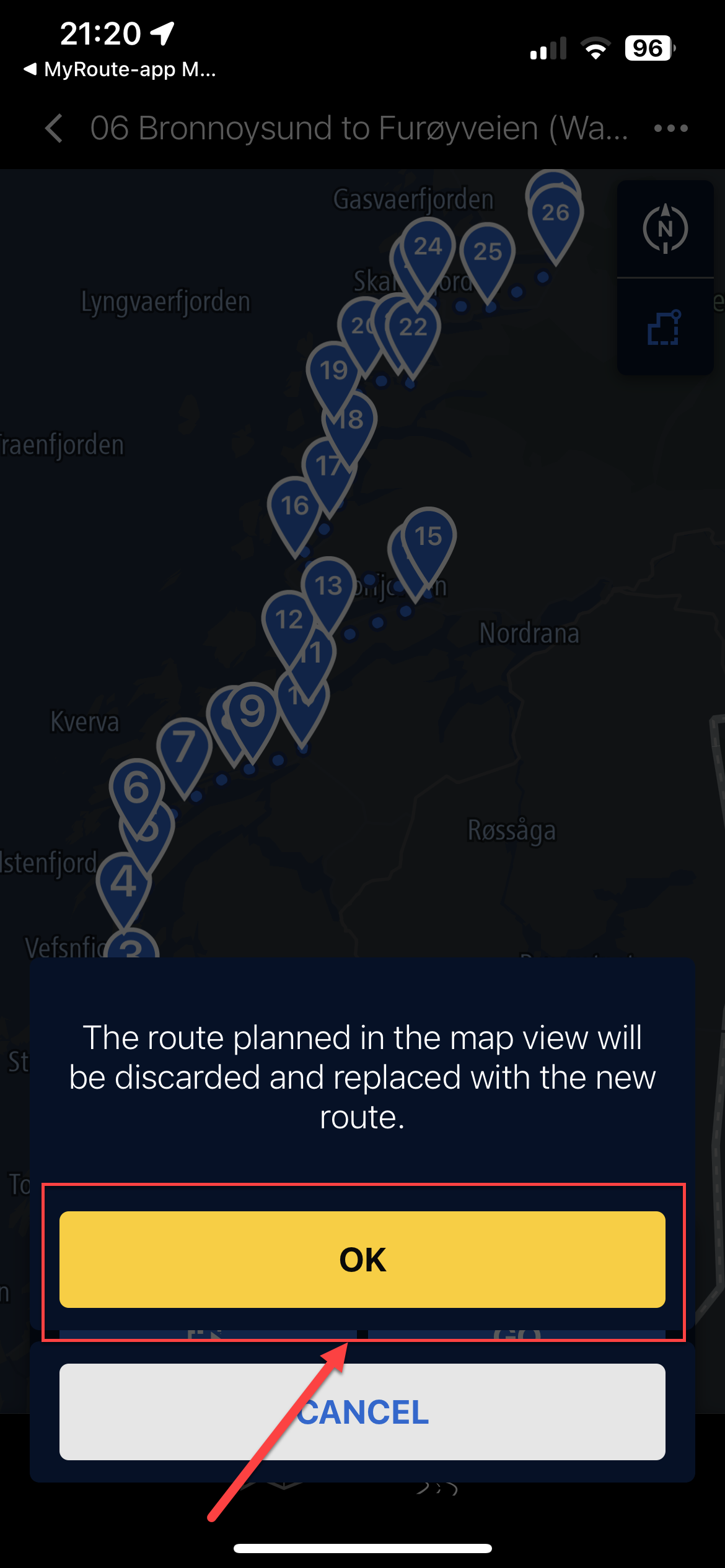
- This will literally plot single dot waypoints on the map in the connected app, with dots joining them. Hit the 'route' button. (as shown)
- It warns the current map will be discarded and replaced, select 'OK'
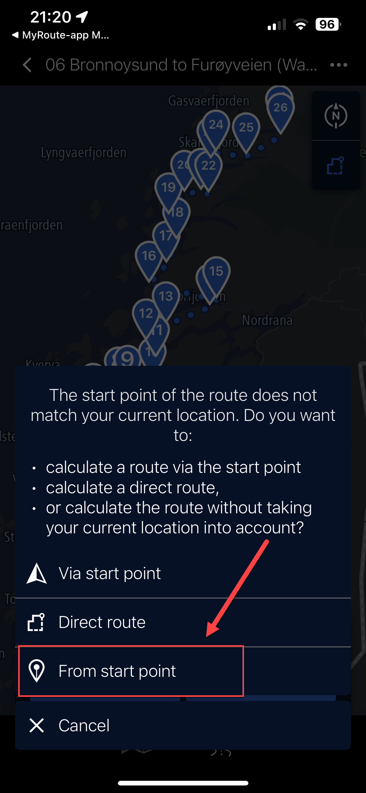
- If you are not near the start point, click 'From start point' and it'll plot the route from waypoint 1 to waypoint (max) on your imported route.
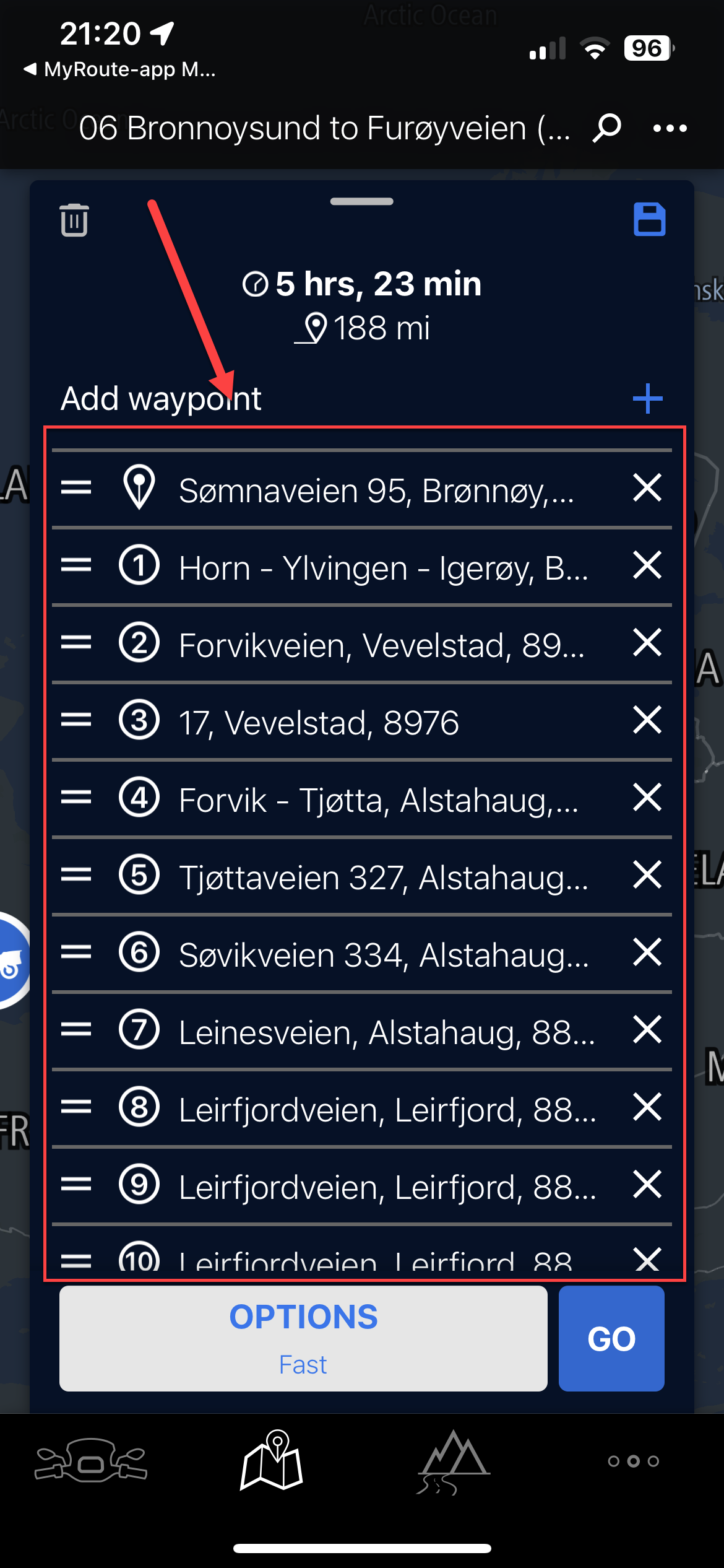
- Not sure if this is the clever point but the Connected app, using the same TomTom map points, grabs the internal waypoint (and name) from the data in the imported route and maps it. Making a full list of named waypoints matching your waypoints in MRA (not by name, but position). These all show as waypoints on the bike's TFT, so can be skipped, announce, etc.
- The route has now been fully built in the Connected App.
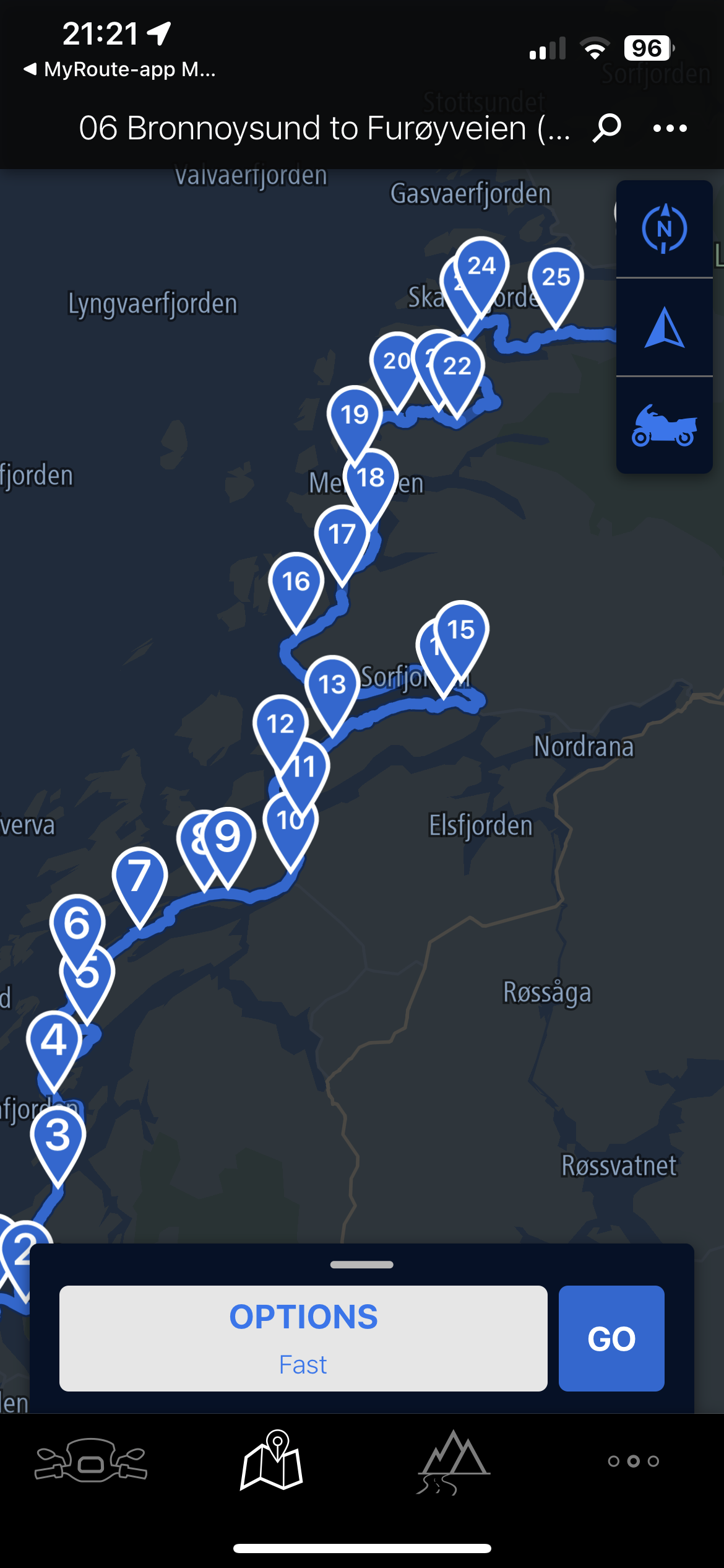
- The route has been saved as a copy and the word '(Waypoints)' has been added. You can keep the old one or delete it. Note too the thumbnail of the route is clearly shown with waypoints.
Lastly, you can of course use the Track with thousands of points and the route will be true, but you will have no ability to see waypoints and therefore if any mid-route issues arise, you cannot really manipulate it (skip), so would have to just re-plot a new route in the app.
Hope this helps those using the same two tools and Ride Safe.
UPDATE: 31st August 2024 (Connected App Version 5.4.0 - now with a black icon)
The limit of 50 waypoints still applies but interestingly, if you add more through the 'Expand' functionality in MRA Route Planner (Gold feature) and import the route as above it seems to 'honour' those waypoints whilst not allowing you to 'convert to list of waypoints' I just tried this for a route from home to Edinburgh with 75 'way/support' points and no matter the setting I chose in the Connected app (shortest, winding, etc.) the route remained the same distance and time
@Nick-Hodge Thank you, Great detail and very helpful.
-
Neat. thanks for sharing. info is useful cheers. oh I'm using the aoocci 6 pro (program)... on my GSA. works a treat....
0
-
undefined Cleo referenced this topic on
Hello! It looks like you're interested in this conversation, but you don't have an account yet.
Getting fed up of having to scroll through the same posts each visit? When you register for an account, you'll always come back to exactly where you were before, and choose to be notified of new replies (either via email, or push notification). You'll also be able to save bookmarks and upvote posts to show your appreciation to other community members.
With your input, this post could be even better 💗
Register Login-
0492.1k
-
7271.6k
-
08144
-
0586
-
0478
-
0263
-
09284
-
35181