UPDATE: SOLVED // MR doesn't recognise a specific (short) road which I did ride (in Belgium)
-
@Trui-Hanoulle No problem. I have downloaded the route so you can change the privacy now. I will look at it in the morning when I switch my PC on and then give you some feedback.
@Nick-Carthew great !
just modified the last bits on day 5, tried the 'cw' tool with 'here', and adapted two locations.
Tomtom gives odd curls in a few places. I can compare with the track I actually rode, so I know for a fact what can be done. (I had a few 'no go' roads so turned around and do not included those of course) : https://www.myrouteapp.com/routetrack/open/3488620 (track now public) -
@Nick-Carthew great !
just modified the last bits on day 5, tried the 'cw' tool with 'here', and adapted two locations.
Tomtom gives odd curls in a few places. I can compare with the track I actually rode, so I know for a fact what can be done. (I had a few 'no go' roads so turned around and do not included those of course) : https://www.myrouteapp.com/routetrack/open/3488620 (track now public)@Trui-Hanoulle I generally find the TomTom map to be more accurate so if there is a discrepancy, I tend towards trusting the TT.
I will look in the morning and give you complete feedback and maybe some tips for getting the best out of all the tools. -
@Nick-Carthew great !
just modified the last bits on day 5, tried the 'cw' tool with 'here', and adapted two locations.
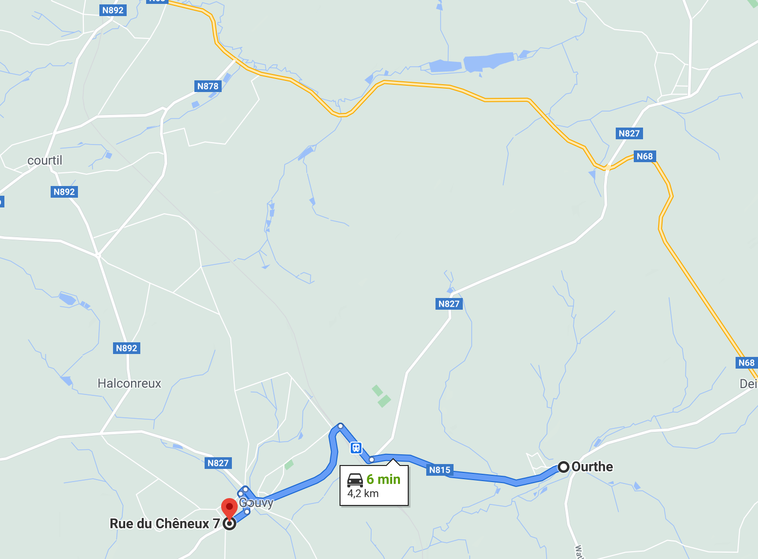
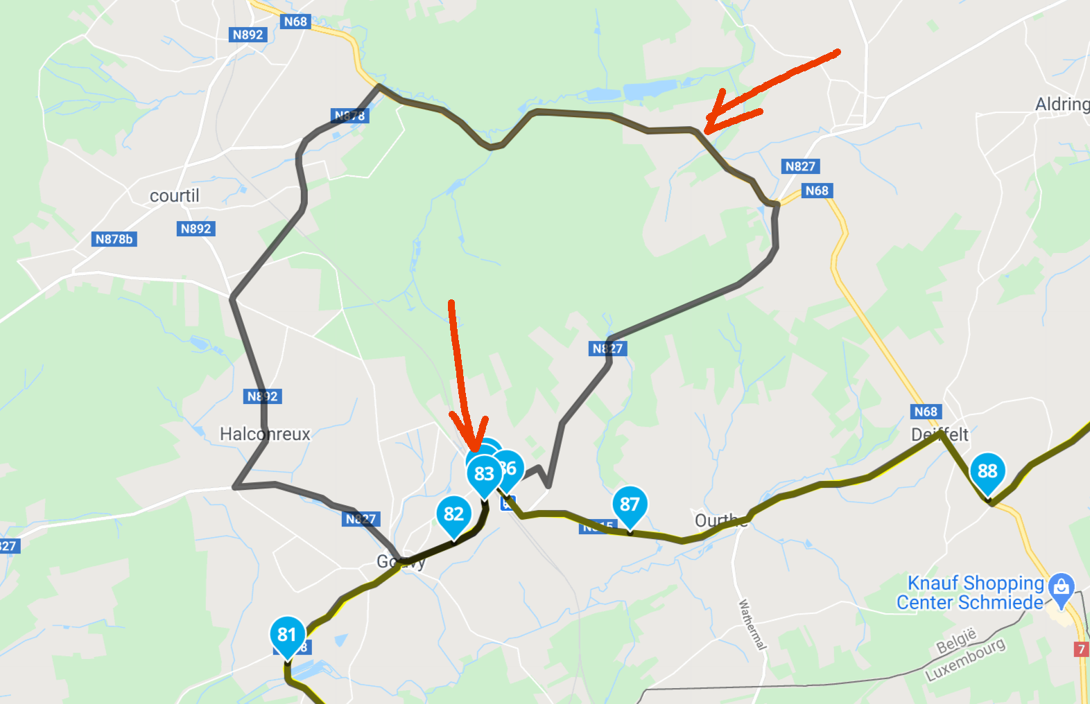
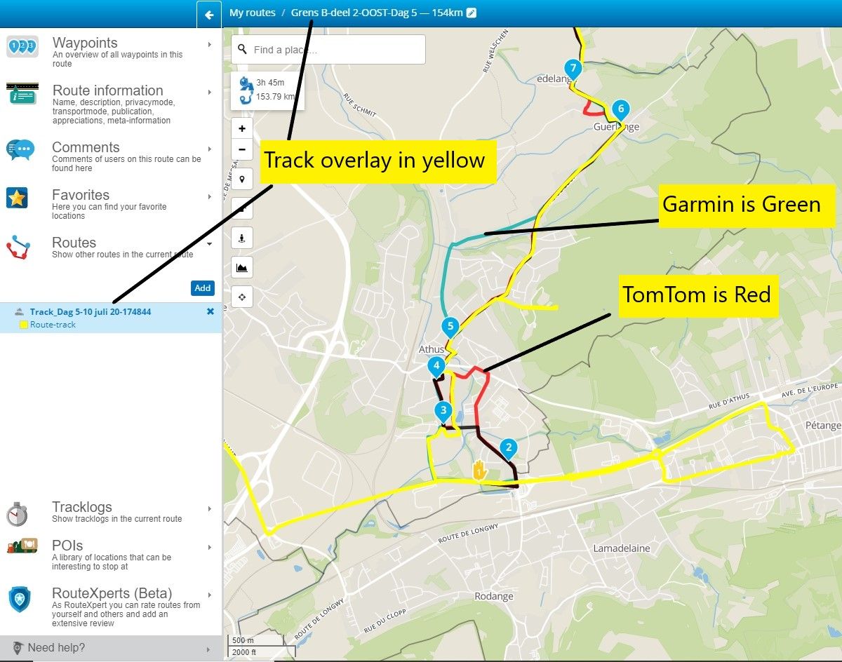
Tomtom gives odd curls in a few places. I can compare with the track I actually rode, so I know for a fact what can be done. (I had a few 'no go' roads so turned around and do not included those of course) : https://www.myrouteapp.com/routetrack/open/3488620 (track now public)Hi @Trui-Hanoulle I have overlaid your track (yellow) by selecting 'Routes' in the left column and then 'Add'. I have the Compare With TomTom and Garmin tool turned on. TT is red and Garmin is green. There are several places where TT and Garmin disagree with your black route and yellow track. If you were to share this route to other users as it is, TT and Garmin users will have problems. Some of the discrepancies are caused because you have chosen to go off road. There are solutions that will enable ALL users to follow your intended route. Some solutions are an easy fix and just require moving a route point and some are a little more complicated. See my next pictures.
Always willing to help if I can.
Triumph Tiger 1200 XRT called Tina.
MRA Navigation Next and SilverFox BJ8 -
@Nick-Carthew great !
just modified the last bits on day 5, tried the 'cw' tool with 'here', and adapted two locations.
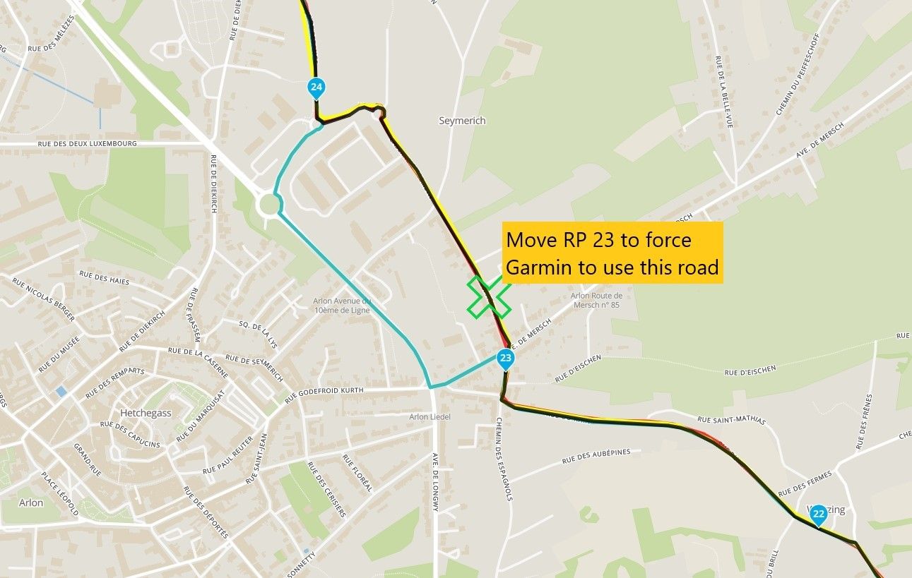
Tomtom gives odd curls in a few places. I can compare with the track I actually rode, so I know for a fact what can be done. (I had a few 'no go' roads so turned around and do not included those of course) : https://www.myrouteapp.com/routetrack/open/3488620 (track now public)@Trui-Hanoulle This is an easy fix:
-
@Nick-Carthew great !
just modified the last bits on day 5, tried the 'cw' tool with 'here', and adapted two locations.
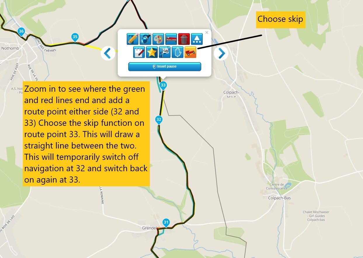
Tomtom gives odd curls in a few places. I can compare with the track I actually rode, so I know for a fact what can be done. (I had a few 'no go' roads so turned around and do not included those of course) : https://www.myrouteapp.com/routetrack/open/3488620 (track now public)@Trui-Hanoulle Some fixes involve a little more work and an understanding of how certain functions work.
-
@Nick-Carthew great !
just modified the last bits on day 5, tried the 'cw' tool with 'here', and adapted two locations.
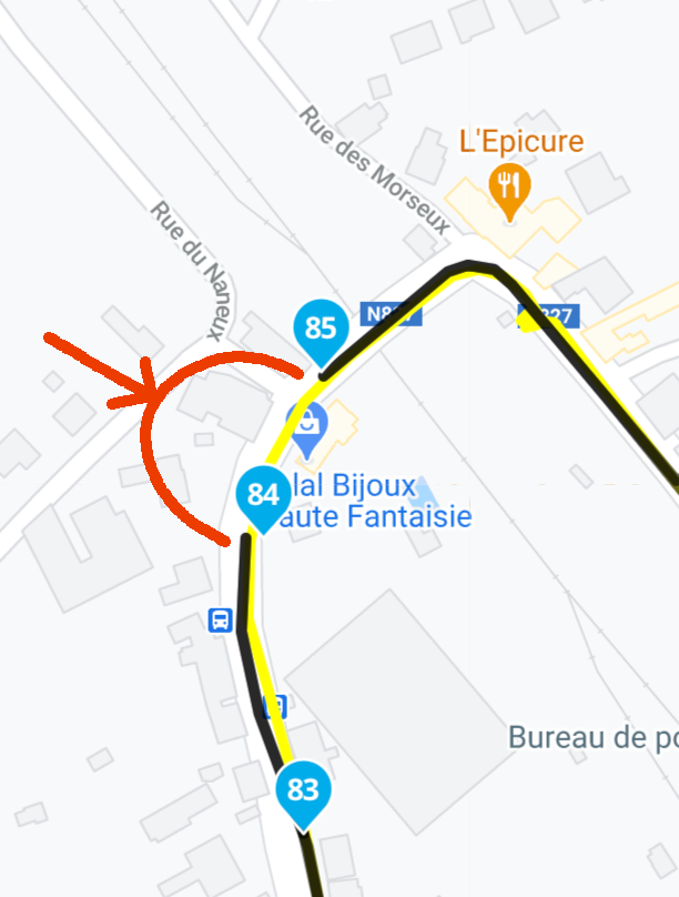
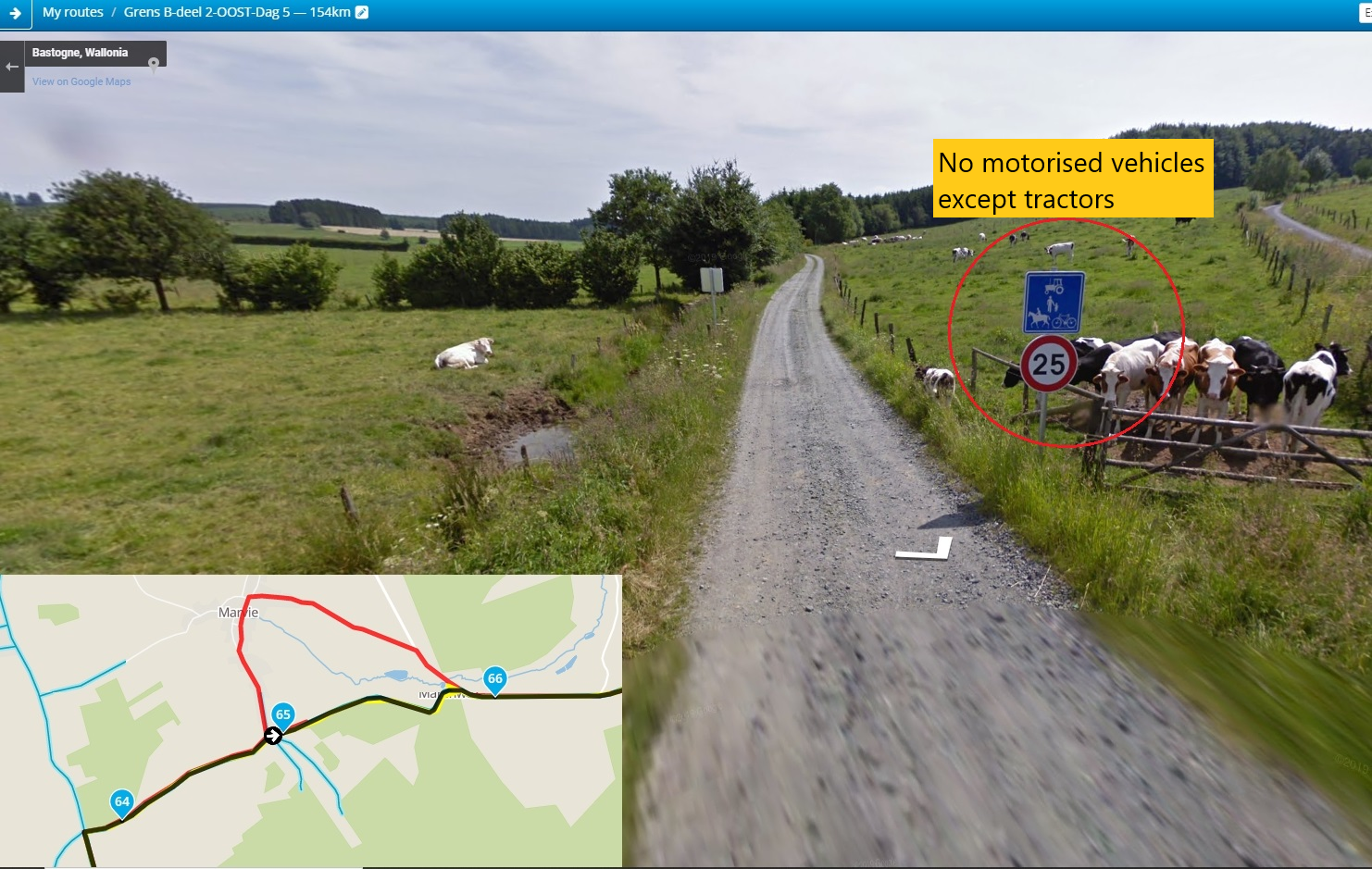
Tomtom gives odd curls in a few places. I can compare with the track I actually rode, so I know for a fact what can be done. (I had a few 'no go' roads so turned around and do not included those of course) : https://www.myrouteapp.com/routetrack/open/3488620 (track now public)@Trui-Hanoulle TomTom won't use this road as there are restrictions to motor vehicles:
Always willing to help if I can.
Triumph Tiger 1200 XRT called Tina.
MRA Navigation Next and SilverFox BJ8 -
@Nick-Carthew great !
just modified the last bits on day 5, tried the 'cw' tool with 'here', and adapted two locations.
Tomtom gives odd curls in a few places. I can compare with the track I actually rode, so I know for a fact what can be done. (I had a few 'no go' roads so turned around and do not included those of course) : https://www.myrouteapp.com/routetrack/open/3488620 (track now public)@Trui-Hanoulle If you would like any further help, please ask. I can even adjust your route for you if you would prefer that. Good luck and keep enjoying making routes

Always willing to help if I can.
Triumph Tiger 1200 XRT called Tina.
MRA Navigation Next and SilverFox BJ8 -
@Trui-Hanoulle TomTom won't use this road as there are restrictions to motor vehicles:
@Nick-Carthew you caught me, haha ! I didn't remember that I ignored this sign indeed ;))) And I shouldn't promote illegal riding, obviously.
-
Hi @Trui-Hanoulle I have overlaid your track (yellow) by selecting 'Routes' in the left column and then 'Add'. I have the Compare With TomTom and Garmin tool turned on. TT is red and Garmin is green. There are several places where TT and Garmin disagree with your black route and yellow track. If you were to share this route to other users as it is, TT and Garmin users will have problems. Some of the discrepancies are caused because you have chosen to go off road. There are solutions that will enable ALL users to follow your intended route. Some solutions are an easy fix and just require moving a route point and some are a little more complicated. See my next pictures.
@Nick-Carthew As for the offroad, this has been a choice and is written as such in the article. I go offroad wherever possible (which is not very often alas in Belgium).
This very image (starting point): I noticed differences indeed + I rode into Lux for fuel (yellow line) but do not want to add that to the route — that's everybody's own choice.
I fixed that one immediately, and will fix the other places too, especially the one with the sign, ha. -
@Trui-Hanoulle If you would like any further help, please ask. I can even adjust your route for you if you would prefer that. Good luck and keep enjoying making routes
@Nick-Carthew Thank you so much for your offer and very good help.
I will change it myself, no worries.
I also modified my own track (yellow) for the final route. In one part I skipped an interesting option to stay closer to the border, in another I added specific waypoints (on the Vennbahn which is a train track still belonging to Belgium...!).Readers do download the gps-files but they are not Americans who would sue the magazine / me for having a mistake somewhere. On the other hand, of course I try to make it as accurate as possible.
THANK you and YESSSS, you bet I enjoy making routes ! But enjoy even more riding them ! Next article up is the Iron Curtain and Italian Northeastern mountains, which I rode afterwards. For Germany I prepared also like mad on MR, for Italy I used old school maps. Both I tracked what I rode for the 2 articles.
I'm a maps freak actually, still taking those along and a compass and altimeter even, hihi.Have a GOOD 2021 and 'talk' to you later, Nick !
Trui Hanoulle -
@Nick-Carthew Thank you so much for your offer and very good help.
I will change it myself, no worries.
I also modified my own track (yellow) for the final route. In one part I skipped an interesting option to stay closer to the border, in another I added specific waypoints (on the Vennbahn which is a train track still belonging to Belgium...!).Readers do download the gps-files but they are not Americans who would sue the magazine / me for having a mistake somewhere. On the other hand, of course I try to make it as accurate as possible.
THANK you and YESSSS, you bet I enjoy making routes ! But enjoy even more riding them ! Next article up is the Iron Curtain and Italian Northeastern mountains, which I rode afterwards. For Germany I prepared also like mad on MR, for Italy I used old school maps. Both I tracked what I rode for the 2 articles.
I'm a maps freak actually, still taking those along and a compass and altimeter even, hihi.Have a GOOD 2021 and 'talk' to you later, Nick !
Trui Hanoulle@Trui-Hanoulle Good luck with your magazine article, I hope you get lots of positive feedback. Let’s hope that we can enjoy lots of rides in 2021.

Hello! It looks like you're interested in this conversation, but you don't have an account yet.
Getting fed up of having to scroll through the same posts each visit? When you register for an account, you'll always come back to exactly where you were before, and choose to be notified of new replies (either via email, or push notification). You'll also be able to save bookmarks and upvote posts to show your appreciation to other community members.
With your input, this post could be even better 💗
Register Login-
014149
-
0606.5k
-
011162
-
024710
-
1886.0k
-
0423
-
17238.5k
-
255612.9k