Garmins bad update and the new Zumo XT
-
Garmin why oh why?
So I update my Zumo 660 only to find out 1.5hrs later that all my Full Europe Maps have gone plus all the functionality and ‘Points of Interest’ eg. Hotels, Restaurants etc have gone also. I now have a unit were I have to install the maps of areas ‘as and when’ I need them….what a con!
So I jumped into the deep end and bought a new Zumo XT, with reluctance to actually buying another Garmin product ever again.
It was faster than the 660, brighter than the 660 and generally I felt it was better than the 660… until that is, I wanted a route putting on it. Test routes were created in MRA installed and ridden….dear dear dear….terrible!
Go off route and the unit recalculates and ‘it’ tells ‘you’ which route you are going on, ignores what waypoints you designed and generally became a useless bit of kit.
After much searching of the web it transpires the new method of riding along a predetermined route involves using ‘Via Points’ or ‘Shape Points’? Whatever happened to good old waypoints for God’s sake? The waypoints created from MRA that appeared on the display as you approached them, the same waypoints that if a road was blocked and you rode off route, the unit would direct you ‘clearly’ I might add, to the quickest way back on your chosen route that you created. So I tried using my test route as a track and converting it to a route….WTF! I tried gpx 1.1 files, and finally the gpx 1.1 BETA file, in a vain desperation that my new £400 sat nav just might be as good as my old one that Garmin ruined, yes ruined, without giving me the option to leave it ‘as is’.
Not good….the damn unit did not import my MRA gpx files properly, with waypoints in-between the start and end of the route.
I was about to seriously consider returning the unit back to Halfords and get a Tom Tom instead when I had a ‘eureka’ moment! Why don’t you try downloading your MRA route as a gpx 1.0 format?
I did, imported into the Garmin and Voila!!! Waypoints!!! Waypoints like flags that the 660 showed. Time to ride the new test route again! Miracle of miracles the waypoint appeared on the screen as I approached them, they were identified with address and postcode, would you believe it!I thought ‘hang on’, what will happen if I go off route will the Zumo design a new route straight to the end waypoint and ignore the others not too far away? So I deliberately went off route, the Zumo XT showed me a new route direct to the next ‘planned’ waypoint! Amazing!
So all my long tours later in the year around Spain (if that goes ahead) might not have been created in vain.
Garmin, please, please, please….do not let your updates bork this up!
Tony
-
Hi @Teejay
Tony,
Yes, it takes some getting used to when you switch from a Zumo 660 to an XT.
You can just use the routes you create in MRA, with the save or export option .gpx 1.1 Beta, which is made especially for the XT.
What I always do is make the Track visible of the route I'm going to drive, then you always see if you have deviated from the route, how you can drive back to the route and immediately check how the XT with recalculating the route goes. So you can leave it on with the XT when you are going to drive a route. Note that if you drive a route based on a track and convert the track to a journey, you may be led directly to the end point.
use the via points in your route to be sure to drive along these points, these are also called at 2 KM and 600 meters and shown in your XT.
I have been using the XT for over 1 year now and am very satisfied with it. I use the XT in combination with MRA Navigation on my iPhone.Garmin Zumo XT3/XT2/XT/BMW Connected Ride Navigator/Tourstart/ MyRouteapp (The App)/...
Een dag niet gelachen is een dag niet geleefd / Een route is net zo goed als deze uitgezet is. -
Hi Hans, thank you for your advice. I assume to make a track visible permanently one finds that in the settings?
Are there other advantages to me (or any XT owner) to use the Beta file format compared to the older 1.0 (route,track,POI) ?This recent painful 'baptism' in using the XT has me thinking if it works leave things alone?

Tony
-
Hi Hans, thank you for your advice. I assume to make a track visible permanently one finds that in the settings?
Are there other advantages to me (or any XT owner) to use the Beta file format compared to the older 1.0 (route,track,POI) ?This recent painful 'baptism' in using the XT has me thinking if it works leave things alone?
Tony
@Teejay I‘am using this combination like Hans as well und it works great. For the route transfer I prefer the new beta GPX Format. The route transfer from my IPad or IPhone via Garmin Drive App and I use the new beta GPX format. The route import takes longer but the route follows exactly what you have planned in Myroute-app.
The newer Garmin devices like Zumo 590, 595 , XT can distinguish between the way points with alarm ( via points) and without alarm ( shaping points). I have only 3-5 via points within a route. All other points are shaping points.The advantage of shaping points is you must not pass them. During riding a route the screen is clean and not full of flags. -
Hi Reinhard, just realised that I know you well my Pan friend, I hope are well and we can meet again at the Portugal rally

So what happens in your setup Reinhard when you have to ride off your planned route (due to road block, diversion etc?). My wish would be that the Garmin system gets you back 'on route' as soon as possible, certainly without removing waypoints or changing the planned route all together.
Tony
-
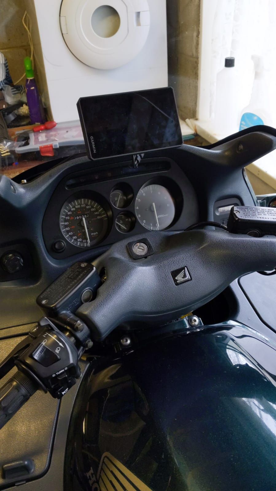
Wired it up to the ST this morning BTW and it looks great!!
Tony
-
Hi @Teejay
Tony,
Yes, it takes some getting used to when you switch from a Zumo 660 to an XT.
You can just use the routes you create in MRA, with the save or export option .gpx 1.1 Beta, which is made especially for the XT.
What I always do is make the Track visible of the route I'm going to drive, then you always see if you have deviated from the route, how you can drive back to the route and immediately check how the XT with recalculating the route goes. So you can leave it on with the XT when you are going to drive a route. Note that if you drive a route based on a track and convert the track to a journey, you may be led directly to the end point.
use the via points in your route to be sure to drive along these points, these are also called at 2 KM and 600 meters and shown in your XT.
I have been using the XT for over 1 year now and am very satisfied with it. I use the XT in combination with MRA Navigation on my iPhone.@Hans-van-de-Ven-MRA-Master
Hans, Reinhard et al,
After reading your replies I thought I would go on a test ride again.
This time a 70 mile circular route comprising of 17 waypoints. I saved 3 copies in gpx 1.1 Beta track, route POI format, a gpx track + POI and finally the old gpx 1.0 track, route, POI. The route made using the HERE setup.
The general idea was to follow the route (of course) but periodically go ‘off route’ or stop and switch the Garmin off plus ask the unit for a petrol station en-route.
Started off with the Beta file. All was going well, I went off route and after a re-calc it did indeed point me back on route towards a waypoint created within MRA. I ignored this, went another way which I knew re-joined the route further along. Again the Garmin steered me along the route but this time it was leading to a waypoint further away from the one I knew I was coming to. I pulled over and stopped the route altogether. I then loaded the gpx 1.0. I was off route and asked for the ‘nearest point’ to re-join. It successfully directed me ‘forward’ along the route and not further back to a known waypoint.
Again I continued along all going well, paused and flipped back to the Beta file. Set off again but later on searched for a known garage en-route. On approaching the small town a heading gave the chosen garage name and distance ahead. As it was by the roadside I just drove straight past it. I ignored the prompts to u-turn back to the garage and after 100M the Garmin ignored the garage stop and continued. I then stopped for 30 minutes before re-starting. On heading back home after 15 miles it was trying to lead me back home via another road? Strange, I ignored this and sure enough I continued on the chosen route only to find 10 miles later the Garmin was trying to take me off route again. I stopped before the Garmin ‘detour and stopped the route. I loaded the gpx 1.0 files and sure enough it was heading me back on my chosen route.
So, I realise Hans/Reinhard that this is a bit ‘hit & miss’ and ideally 2 bikes each with the different formats would be better than me stopping, starting and changing formats. I agree the Beta format does not have the waypoint flags and therefore there may be no limit to Via or Shape points when imported into the Garmin. I am allowed 29 waypoints in the 1.0 format.
The practise of importing a ‘track’ and letting the Garmin convert to ‘route’ does not fill me with confidence, although it may be perfect! I also realise that shaping routes and adding points via the Garmin is something I am not used to doing.
I am I guess not that proficient in using Sat Navs and therefore just want something simple that just works. I want a unit or file format that takes me from A to G and if I go off route at D it will not guide me towards B or C but point me in the direction of E and F. I don’t want to find myself in the middle of nowhere wrestling with a unit that does not want to go where I want it to go.
After further practise Hans and speaking to, or reading about, other users methods or procedures then I may see the benefits of using the Beta format.
As the famous Eric Morecambe (British comedian) once said whilst sat at a piano and getting a telling off from Andre Previn, “I’m playing all the right notes, but not necessarily in the right order?”.
Tony
-
My preference for the XT, after much testing like yourself, is to use the Beta export but I only ever use shaping points and I use the Trip Planner exclusively.
I actually put at least 1 shaping point on every road on the route.
Yes it means extra work creating the route but for those times when I do go off route there are less chances for dodgy recalculations.
I did use the Track Visible option for a while but I have found it pointless due to the amount of shaping points I add.For me Garmin Tracks have only one purpose.
UK Green Lanes (Byways Open to All Traffic).
I plot them on the OS Maps Software and Transfer directly to the XT.
No more accidentally going down a Bridleway and enduring the wrath of the Walkers and Horse Riders.
Hello! It looks like you're interested in this conversation, but you don't have an account yet.
Getting fed up of having to scroll through the same posts each visit? When you register for an account, you'll always come back to exactly where you were before, and choose to be notified of new replies (either via email, or push notification). You'll also be able to save bookmarks and upvote posts to show your appreciation to other community members.
With your input, this post could be even better 💗
Register Login-
08109
-
7281.7k
-
08167
-
0587
-
0372
-
0492.1k
-
04146
-
0216