IRAN planning problems
-
Hi, i am trying to prepare tracks for Iran
example: https://www.myrouteapp.com/it/social/route/10647187?mode=shareit doesn't work properly and i do not understand why. I need to export in GARMIN XT and i know i have to use here maps.
Open street shows me better maps but finally doesn't works.
In garmin i will use openstreets Iran map normal or DEM.2nd problem roads names are in arabic is there a tips to see in english?
-
 undefined Nick Carthew moved this topic from [Web] Problems, Bugs and other Issues on
-
Hi, i am trying to prepare tracks for Iran
example: https://www.myrouteapp.com/it/social/route/10647187?mode=shareit doesn't work properly and i do not understand why. I need to export in GARMIN XT and i know i have to use here maps.
Open street shows me better maps but finally doesn't works.
In garmin i will use openstreets Iran map normal or DEM.2nd problem roads names are in arabic is there a tips to see in english?
@DANIELZ77 Have you tried changing the profile of the route to car? I rode almost the same route in October 2024 using an OSM map on a Garmin ZUMO XT.
-
Hi, i am trying to prepare tracks for Iran
example: https://www.myrouteapp.com/it/social/route/10647187?mode=shareit doesn't work properly and i do not understand why. I need to export in GARMIN XT and i know i have to use here maps.
Open street shows me better maps but finally doesn't works.
In garmin i will use openstreets Iran map normal or DEM.2nd problem roads names are in arabic is there a tips to see in english?
@DANIELZ77 I used the OSM map that I downloaded from BBBike and it showed a lot of Latin names that sometimes were translated in a bit crooked way, but still understandable.
-
Hi, i am trying to prepare tracks for Iran
example: https://www.myrouteapp.com/it/social/route/10647187?mode=shareit doesn't work properly and i do not understand why. I need to export in GARMIN XT and i know i have to use here maps.
Open street shows me better maps but finally doesn't works.
In garmin i will use openstreets Iran map normal or DEM.2nd problem roads names are in arabic is there a tips to see in english?
@DANIELZ77, maybe not everyone knows this, but it is perfectly possible to load OSM maps to your Garmin device. If you do that, also the advised map to use in the planner is the OSM map.
Check out https://garmin.bbbike.org/ if you are interested in this.
I am just an enthusiastic MRA user, and hope you will be one too!
Most motorcycle problems are caused by the nut that connects the handlebar to the saddle.
Check out RideSleepRepeat.eu, a biker community for sharing stays across Europe
-
@DANIELZ77, maybe not everyone knows this, but it is perfectly possible to load OSM maps to your Garmin device. If you do that, also the advised map to use in the planner is the OSM map.
Check out https://garmin.bbbike.org/ if you are interested in this.
@Con-Hennekens Ty in advance for your precious help. But my problem is not on my garmin xt device but in myrouteappweb.... the planner doesn't work on Iran map using openstreet or here maps. I don't know what's wrong.
-
@Con-Hennekens i used bbbike and i know i can load on garmin those open maps. My problem is on myrouteweb planner that doesn't works on any map with iran.
-
@Con-Hennekens i used bbbike and i know i can load on garmin those open maps. My problem is on myrouteweb planner that doesn't works on any map with iran.
@DANIELZ77, commercial providers like TomTom lack an enormous amount of detail, I can see that, probably not allowed by the regime. The OSM map seems to be pretty detailed, though in Arabic. I opened your route and I can plan without problem. What exactly makes it unusable for you?
I am just an enthusiastic MRA user, and hope you will be one too!
Most motorcycle problems are caused by the nut that connects the handlebar to the saddle.
Check out RideSleepRepeat.eu, a biker community for sharing stays across Europe
-
@DANIELZ77, commercial providers like TomTom lack an enormous amount of detail, I can see that, probably not allowed by the regime. The OSM map seems to be pretty detailed, though in Arabic. I opened your route and I can plan without problem. What exactly makes it unusable for you?
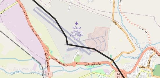
@Con-Hennekens i send 2 simple waypoints and the route is illogic ….. it goes inside the airport
 and the hotel destination is unavaiable. I dont know what to do
 -
@Con-Hennekens i send 2 simple waypoints and the route is illogic ….. it goes inside the airport
and the hotel destination is unavaiable. I dont know what to do@DANIELZ77, if this is what you mean:
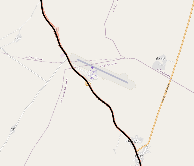
I don't see why this is illogical. just a road that goes near an airport. If you wat another route, just add shaping points.
I am just an enthusiastic MRA user, and hope you will be one too!
Most motorcycle problems are caused by the nut that connects the handlebar to the saddle.
Check out RideSleepRepeat.eu, a biker community for sharing stays across Europe
-
@DANIELZ77, if this is what you mean:
I don't see why this is illogical. just a road that goes near an airport. If you wat another route, just add shaping points.
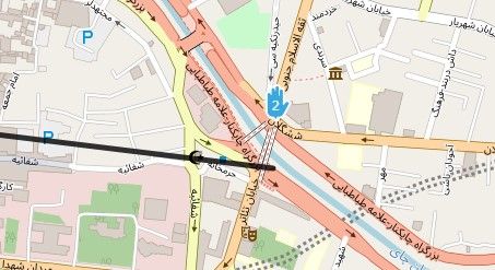
This is the problem. waypoints not respected and i must pass inside airport
") i think that iranias will shot me
i think that iranias will shot me -
tried it on my Web browser, Firefox and all seemed to work OK. Weypoints in sensible places and route line followed the road. But only when using OSM, which aligns with Google satelite. HERE and Tom Tom looked useless. The HERE route does go through the airport, but not on the line shown in your screen shot
-
tried it on my Web browser, Firefox and all seemed to work OK. Weypoints in sensible places and route line followed the road. But only when using OSM, which aligns with Google satelite. HERE and Tom Tom looked useless. The HERE route does go through the airport, but not on the line shown in your screen shot
@Tony-13 said in IRAN planning problems:
tried it on my Web browser, Firefox and all seemed to work OK. Weypoints in sensible places and route line followed the road. But only when using OSM, which aligns with Google satelite. HERE and Tom Tom looked useless. The HERE route does go through the airport, but not on the line shown in your screen shot
so considering that I have to create tracks that will have to run on the garmin XT.... what should I do? how should I set up myroute? thank you for your help
Hello! It looks like you're interested in this conversation, but you don't have an account yet.
Getting fed up of having to scroll through the same posts each visit? When you register for an account, you'll always come back to exactly where you were before, and choose to be notified of new replies (either via email, or push notification). You'll also be able to save bookmarks and upvote posts to show your appreciation to other community members.
With your input, this post could be even better 💗
Register Login-
1542.7k
-
024627
-
27462.9k
-
113492
-
2651
-
-15189
-
06173