Skip to content
  • Categories
  • Recent
  • Popular
  • Support
  • MyRoute-app
Collapse
Brand Logo

MRA Community Forum

  1. Home
  2. MyRoute-app Routeplanner
  3. [Web] Problems, Bugs and other Issues
  4. Vraagje mbt Plannen met behulp van satellietbeelden

Vraagje mbt Plannen met behulp van satellietbeelden

Scheduled Pinned Locked Moved [Web] Problems, Bugs and other Issues
3 Posts 2 Posters 238 Views 1 Watching
  • Oldest to Newest
  • Newest to Oldest
  • Most Votes
Reply
  • Reply as topic
Log in to reply
This topic has been deleted. Only users with topic management privileges can see it.
  • undefined Offline
    undefined Offline
    Erik 35
    wrote on 23 Jan 2025, 15:37 last edited by
    #1

    Normaal gesproken maak ik altijd gebruik van de mogelijkheid om de map met satellietbeelden te gebruiken tijdens het plannen van routes .
    tot van middag stonden deze altijd in het rijtje van de te selecteren kaarten hier staan nu nog maar drie mogelijkheden Standaard Open street map,Tom Tom ,Here .
    Doe ik iets fout ik heb er vanochtend nog gewoon mee kunnen plannen ?

    Normally I always take advantage of the option to use the satellite images folder when planning routes.
    Until this afternoon these were always in the list of maps to be selected, here there are now only three options. Standard Open street map, Tom Tom , Here .
    Am I doing something wrong? I was able to plan with it this morning?

    undefined 1 Reply Last reply 23 Jan 2025, 15:51
    0
    • undefined Erik 35
      23 Jan 2025, 15:37

      Normaal gesproken maak ik altijd gebruik van de mogelijkheid om de map met satellietbeelden te gebruiken tijdens het plannen van routes .
      tot van middag stonden deze altijd in het rijtje van de te selecteren kaarten hier staan nu nog maar drie mogelijkheden Standaard Open street map,Tom Tom ,Here .
      Doe ik iets fout ik heb er vanochtend nog gewoon mee kunnen plannen ?

      Normally I always take advantage of the option to use the satellite images folder when planning routes.
      Until this afternoon these were always in the list of maps to be selected, here there are now only three options. Standard Open street map, Tom Tom , Here .
      Am I doing something wrong? I was able to plan with it this morning?

      undefined Offline
      undefined Offline
      Nick Carthew
      RouteXpert
      wrote on 23 Jan 2025, 15:51 last edited by
      #2

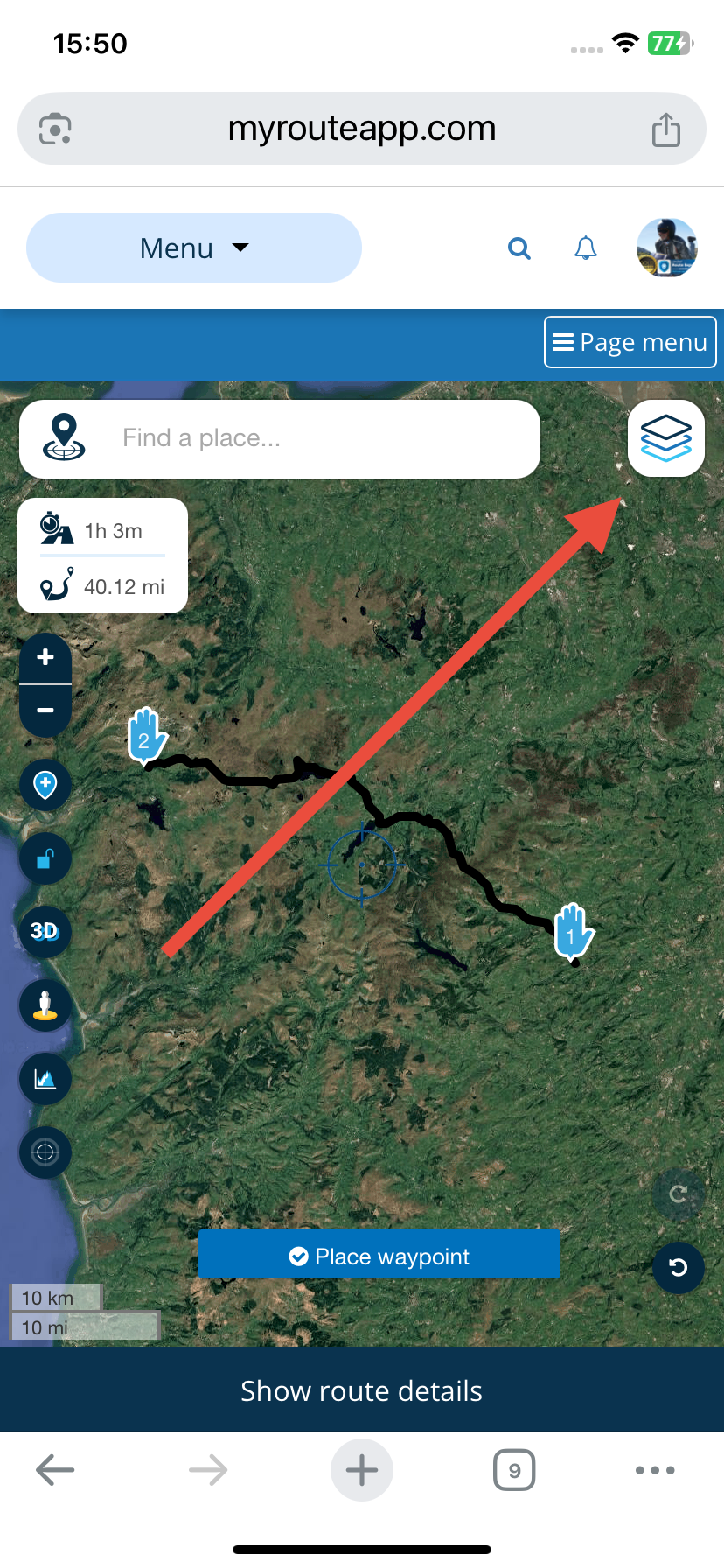
      @Erik-35 The maps that you list are the planning maps. Google Satellite is one of the overlay maps.
      149c9416-ca88-455f-9920-6aa649c27f76-image.png

      Always willing to help if I can.
      Triumph Tiger 1200 XRT called Tina.
      MRA Navigation Next and SilverFox B8J bar buttons.
      Quadlock wireless mount for IPhone 11.
      Cardo Scala Packtalk Bold.
      TomTom Rider 500. (In the cupboard now)

      1 Reply Last reply
      0
      • undefined Offline
        undefined Offline
        Erik 35
        wrote on 24 Jan 2025, 08:10 last edited by
        #3

        Bedankt gewoon overheen gekeken .
        soms kan het zo simpel zijn 👍

        1 Reply Last reply
        0
        • undefined Hans van de Ven MR.MRA locked this topic on 24 Jan 2025, 08:18
        Reply
        • Reply as topic
        Log in to reply
        • Oldest to Newest
        • Newest to Oldest
        • Most Votes

        1/3

        23 Jan 2025, 15:37


        ACTIVE USERS
        undefined
        Nick Carthew
        about 18 hours ago
        undefined
        Erik 35
        22 Apr 2025, 16:08
        POPULAR TOPICS
        • 12 Tage in den Seealpen mit MRA und es war eher NICHT gut..
          undefined
          Thomas Neumeyer
          about 13 hours ago
          0
          18
          316

        • New beta! 4.4.0 (400)
          undefined
          Arno 0
          about 12 hours ago
          9
          8
          63

        • Myroute App sluit tijdens het rijden vanzelf af.
          undefined
          Rene NT
          about 10 hours ago
          0
          5
          101

        • Anyone successful using Off Road .gpx files
          undefined
          Kenny 1
          about 15 hours ago
          0
          5
          83

        • Garmin XT2 waypoint
          undefined
          Carl Lee
          about 8 hours ago
          0
          5
          113

        • route calculatie werkt sinds vanmiddag niet. ?
          undefined
          Rob Veerman
          about 9 hours ago
          0
          6
          109

        • Looking for a Route from Roermond to Ijmuiden, Netherlands?
          undefined
          Rob Veerman
          about 9 hours ago
          0
          4
          86

        • route non revĂȘtue
          undefined
          Herman Veldhuizen
          about 12 hours ago
          0
          3
          67
        MY GROUPS
        • Login

        • Login or register to search.
        1 / 1
        • First post
          1/3
          Last post
        0
        • Categories
        • Recent
        • Popular
        • Support
        • MyRoute-app