MRA Navigation: Show Route AND Track simultaneously
-
Hi,
Sorry if this question has been discussed ealrier. Simply I couldn‘t find .
Coming from a Zumo XT where the user can select a track to be displayed while navigating a route I would like to know whether this option is (or will be) possible with MRA Navigation.
Showing both route and track while navigating would make it much easier to follow detours or deviations for sightseeing or gas stations etc and then finding back to your originally planned tour.
Any chance to get this feature in MRA?PS: Using: MRA on an iPhone 11,
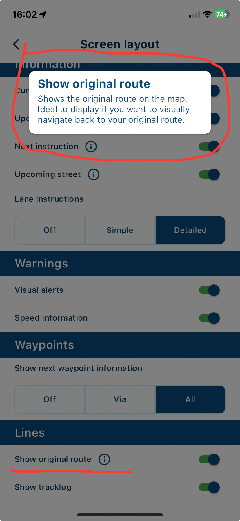
@Kerbel In Navigation settings - Screen layout, there is an option to see original route, this draws a white line of your original route should you deviate away from it.

-
@Kerbel In Navigation settings - Screen layout, there is an option to see original route, this draws a white line of your original route should you deviate away from it.

@Nick-Carthew thanks, that sounds very good.
-
@Kerbel In Navigation settings - Screen layout, there is an option to see original route, this draws a white line of your original route should you deviate away from it.

Problem is the "track" is difficult to see, and I.. not sure its a true track, but the route it calculated at the time you started it.
For example, you plan a trip on MRA for your Garmin, then set to display track - this will be 100% what was on screen when you exported it.
I think with MRA it will calculate the route when you select start, if, say, MRA thinks there is a road closure it will plan around it, and this will be the white line "original route"
The main road out of my town shows as closed on MRA and Zumo XT and has done for almost 2 years, I drive it often and have never seen it closed.
Also on a trip I gave up on MRA as it kept saying roads closed in Germany when they weren't- XT is as bad, so I tend to run a route to remind me of stop points, but use Track to ensure I stay on planned path.
Overall MRA and the XT are both worse than my old 345 as the "live traffic" stuff is hopeless, and cannot be turned off on either.
I only use MRA for getting me to final destination (last mile kind of thing) in car and use Garmin tracks for bike trips.
MRA is very neat, but makes awful routing decisions at times....
....you can choose to navigate track of course, but then lose all your waypoints which I like to tell me where points of interest and stops are - real handy in group as you can say "if we get split up go to next coffee stop" or whatever
IF you could navigate the track and get alerts approaching waypoint it would be MUCH better.
-
Problem is the "track" is difficult to see, and I.. not sure its a true track, but the route it calculated at the time you started it.
For example, you plan a trip on MRA for your Garmin, then set to display track - this will be 100% what was on screen when you exported it.
I think with MRA it will calculate the route when you select start, if, say, MRA thinks there is a road closure it will plan around it, and this will be the white line "original route"
The main road out of my town shows as closed on MRA and Zumo XT and has done for almost 2 years, I drive it often and have never seen it closed.
Also on a trip I gave up on MRA as it kept saying roads closed in Germany when they weren't- XT is as bad, so I tend to run a route to remind me of stop points, but use Track to ensure I stay on planned path.
Overall MRA and the XT are both worse than my old 345 as the "live traffic" stuff is hopeless, and cannot be turned off on either.
I only use MRA for getting me to final destination (last mile kind of thing) in car and use Garmin tracks for bike trips.
MRA is very neat, but makes awful routing decisions at times....
....you can choose to navigate track of course, but then lose all your waypoints which I like to tell me where points of interest and stops are - real handy in group as you can say "if we get split up go to next coffee stop" or whatever
IF you could navigate the track and get alerts approaching waypoint it would be MUCH better.
@Robert-Randall said in MRA Navigation: Show Route AND Track simultaneously:
IF you could navigate the track and get alerts approaching waypoint it would be MUCH better.
You might want to try this:
Plan a route with the MRA Webplanner and use any routing engine that best fits your needs (HERE, OSM, TomTom).
Set "Navigate routes as tracks" in the MRA NN app, then open the route and start navigation.
You will see the original planned route as a white line and the automatically calculated route as a blue line. All your VIA points will show up (or all shaping points as well if you enable "Use all waypoints").
