Tunnels and navigation

-
Hi, what I forgot in my list after the trip to Norway.
The Here map did not show tunnels and there are a lot in Norway.
I have not noticed how it is in other countries, may be you can report.The other problem was, if the tunnel is very long (and there some in Norway) then first the position arrow follows the street, but after some time (10min) it stops moving and the map starts to turn around to left, to right until you are out of the tunnel again.
If for example there is an exit or a roundabout, you have no idea where to drive.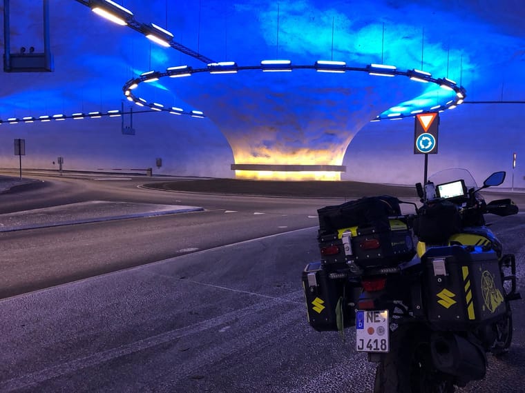
Hardware
iPhone 12 pro (iOS 26.2.1)
iPad (7.Gen.) 18.7.3
Oukitel RT3 Pro (Andr. 14)
Wireless CarPlay mit (Elebest C650)
Wired CarPlay (SEAT Arona - 2021)
MRA Workshops in Deutsch sind hier zu finden -
Hi, what I forgot in my list after the trip to Norway.
The Here map did not show tunnels and there are a lot in Norway.
I have not noticed how it is in other countries, may be you can report.The other problem was, if the tunnel is very long (and there some in Norway) then first the position arrow follows the street, but after some time (10min) it stops moving and the map starts to turn around to left, to right until you are out of the tunnel again.
If for example there is an exit or a roundabout, you have no idea where to drive.@Jörgen I think that you are using an extreme example of a tunnel. I can’t think of many tunnels with a roundabout in the middle apart from Norway. I presume that there was signposts in the tunnel?
Always willing to help if I can.
Triumph Tiger 1200 XRT called Tina.
MRA Navigation Next and SilverFox BJ8 -
@Jörgen I think that you are using an extreme example of a tunnel. I can’t think of many tunnels with a roundabout in the middle apart from Norway. I presume that there was signposts in the tunnel?
@Nick-Carthew said in Tunnels and navigation:
I presume that there was signposts in the tunnel?
I forgot how to use them
")
Yes they helped me to get out.
Hardware
iPhone 12 pro (iOS 26.2.1)
iPad (7.Gen.) 18.7.3
Oukitel RT3 Pro (Andr. 14)
Wireless CarPlay mit (Elebest C650)
Wired CarPlay (SEAT Arona - 2021)
MRA Workshops in Deutsch sind hier zu finden -
@Nick-Carthew said in Tunnels and navigation:
I presume that there was signposts in the tunnel?
I forgot how to use them
Yes they helped me to get out.
But usually the satnav follows the treet in normal speed until the exit.
-
GPS won't work unless you have line-of-sight of 4 or more satellites. You're not going to get that in a tunnel.
I suspect the encumbent satnav makers have marked the tunnels in some way, and when you enter that segment of road they then make some sort of assumption about your average speed through the tunnel to keep your position approximately correct.
I can't see any other way of doing it (unless there's WiFi in the tunnels to locate you).
i.e. what Jörgen said - much more succintly than me!
-
Hi, what I forgot in my list after the trip to Norway.
The Here map did not show tunnels and there are a lot in Norway.
I have not noticed how it is in other countries, may be you can report.The other problem was, if the tunnel is very long (and there some in Norway) then first the position arrow follows the street, but after some time (10min) it stops moving and the map starts to turn around to left, to right until you are out of the tunnel again.
If for example there is an exit or a roundabout, you have no idea where to drive.@Jörgen thanks for sharing! Long tunnels will always be an issue. 10 minutes in a tunnel is extreme.
When I was driving through a Swiss tunnel a few months back, both our app and Google Maps stopped positioning correctly in a tunnel after a few minutes at almost the same time!
The app guesses your position as soon as you enter a tunnel and the signal weakens. This is a HERE SDK feature. After some time, it just becomes way too unsure to guess and without GPS, it won’t ever know for sure.
Luckily tunnels are always one entry / exit. Well….then there is this in Norway
Nothing to do about it really

-
GPS won't work unless you have line-of-sight of 4 or more satellites. You're not going to get that in a tunnel.
I suspect the encumbent satnav makers have marked the tunnels in some way, and when you enter that segment of road they then make some sort of assumption about your average speed through the tunnel to keep your position approximately correct.
I can't see any other way of doing it (unless there's WiFi in the tunnels to locate you).
i.e. what Jörgen said - much more succintly than me!
@richtea999 correct. Your location is extrapolated based on the tunnels coordinates and your estimated speed.
-
Hi, what I forgot in my list after the trip to Norway.
The Here map did not show tunnels and there are a lot in Norway.
I have not noticed how it is in other countries, may be you can report.The other problem was, if the tunnel is very long (and there some in Norway) then first the position arrow follows the street, but after some time (10min) it stops moving and the map starts to turn around to left, to right until you are out of the tunnel again.
If for example there is an exit or a roundabout, you have no idea where to drive.@Jörgen : das Bild kommt mir bekannt vor, mit dem Signal und verhalten auf der Karte auch, da hilft sich auch Richtungen bzw. nächste Ziele zu merken ..
In den meisten Tunneln lief es aber sehr gut habe mich oft gewundert das es noch ging !!
Wars dieser hier … An der Großen Brücke
VG

-
Using every day underground rondabout and underground exits in Barcelona city (on the Ronda)
Example of one ‘double decker’
https://maps.app.goo.gl/r1myiQ5kqrY42uQ66?g_st=ic -
It might (I am not sure) also depend on your hardware. As far as I know (and I am not sure
) Google location services uses GPS (obviously) but also uses compass (a REAL one, not the GPS extrapolated ones, some phones have REAL compasses) and even gyroscopic hardware (if available).Maybe this could be one of the seldom occasion on which the "enhanced accuracy" settings would be helpful, since that uses GSM and wifi signals too. Those probably are available in some tunnels. But I have never been to Norway (yet
). -
Anyway, I just wanted to pass along this finding. I am not a programmer and have no idea how to do something like that, but I could imagine that after losing the GPS signal and after info of the map data, one is in a tunnel, that then a routine with the normal average speed drives through the tunnel, eventually a departure takes if necessary and one comes out so about the same time at the exit.
Hello! It looks like you're interested in this conversation, but you don't have an account yet.
Getting fed up of having to scroll through the same posts each visit? When you register for an account, you'll always come back to exactly where you were before, and choose to be notified of new replies (either via email, or push notification). You'll also be able to save bookmarks and upvote posts to show your appreciation to other community members.
With your input, this post could be even better 💗
Register Login-
08153
-
07149
-
1571
-
08174
-
0424
-
0217
-
7221.4k
-
0341.6k