Route planning based on daily drive time
-
Route planning. Is it possible to create legs based on time of travel? For instance I want to travel from the east coast to Arizona with an average daily drive time between 8 and 10 hours. If I start at A and will end at B I would like MRA to suggest stop points in-between at the designated travel times.
@Johnny-V-Rodgers
With all due respect, that is called route planning and it is exactly what the MRA Route Planner is used for.
Let's say your route starts from Brooklyn Bridge, NY, position a route point somewhere west of there to gauge a rough travel time and distance.
In my example below, I have positioned the end point just east of Columbus and the travel time is 8hrs with a distance of a little over 500 miles. The system will use the fastest route, so highways, if you would prefer smaller roads drag the end point back a little and start adding additional route points on the roads that you want to use taking in any sights or towns that you would like to visit.
Creating your own routes rather than relying on a system built route is so much more enjoyable.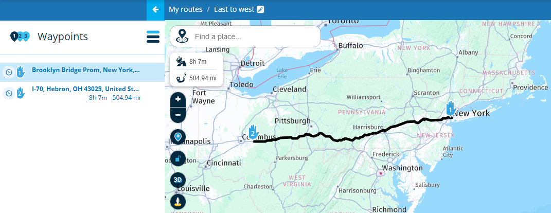
Always willing to help if I can.
Triumph Tiger 1200 XRT called Tina.
MRA Navigation Next and SilverFox BJ8 -
Route planning. Is it possible to create legs based on time of travel? For instance I want to travel from the east coast to Arizona with an average daily drive time between 8 and 10 hours. If I start at A and will end at B I would like MRA to suggest stop points in-between at the designated travel times.
@Johnny-V-Rodgers I do it in same style as @Nick-Carthew explained. After I splitted in daily stints, I do it once more to set waypoints for pause an refuelling

-
@Johnny-V-Rodgers
With all due respect, that is called route planning and it is exactly what the MRA Route Planner is used for.
Let's say your route starts from Brooklyn Bridge, NY, position a route point somewhere west of there to gauge a rough travel time and distance.
In my example below, I have positioned the end point just east of Columbus and the travel time is 8hrs with a distance of a little over 500 miles. The system will use the fastest route, so highways, if you would prefer smaller roads drag the end point back a little and start adding additional route points on the roads that you want to use taking in any sights or towns that you would like to visit.
Creating your own routes rather than relying on a system built route is so much more enjoyable.@Nick-Carthew Thank you for your response. I have been using it the way you demonstrated and it works very well. It would be nice if the program would place markers on long routes based on the desired travel time. NC to AZ is a long route. If the program placed a marker, tic mark or something every 8 hours of travel time along the route it would just add a quick stop point along the way to search for lodging rather than picking a point only to find out it is 12 hours and then have to back track to try and pinpoint an area around 8 hours. I hope this makes sense. This is an awesome program, I'll never go back to Garmin Basecamp.
-
@Nick-Carthew Thank you for your response. I have been using it the way you demonstrated and it works very well. It would be nice if the program would place markers on long routes based on the desired travel time. NC to AZ is a long route. If the program placed a marker, tic mark or something every 8 hours of travel time along the route it would just add a quick stop point along the way to search for lodging rather than picking a point only to find out it is 12 hours and then have to back track to try and pinpoint an area around 8 hours. I hope this makes sense. This is an awesome program, I'll never go back to Garmin Basecamp.
@Johnny-V-Rodgers Great to hear that you'll never go back to BC but hardly surprising

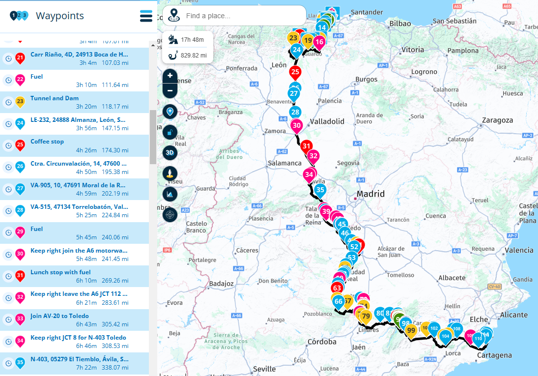
If you get a few more route points on the map then deciding where and when you're going to stop is a little easier. The screenshot below is a tour I made in 2019 from the north of Spain down to the Mediterranean, a distance of a little over 800 miles. The basic shape of the route was formed by places that we wanted to visit. I can look down the waypoint list and choose a time or distance for where I would like to stop, either for coffee, fuel or a bed for the night. Once I have the overnight stops in place, I'll split the main route into daily routes and then work on them further giving each route more detail which normally means finding the twisty roads
-
@Nick-Carthew that's a lot of waypoints. I haven't figured the colors out yet. Do you assign the colors as to what they stand for, like pink for fuel? I still have a lot to learn with this program.
-
@Nick-Carthew that's a lot of waypoints. I haven't figured the colors out yet. Do you assign the colors as to what they stand for, like pink for fuel? I still have a lot to learn with this program.
@Johnny-V-Rodgers This Route was from 2019 and I now use the colour scheme from the RouteXperts.
Blue - Just used for shaping the route.
Yellow - From the exact position of the route point, something can be seen, a castle on a hill, a waterfall on the right or a significant mountain on the horizon. Information for all coloured route points is added in the note.
Green - A place for a photo stop
Red - All other stops, fuel, coffee, lunch or to visit an attraction, route point icon used for quick recognition.
Pink - Used in conjunction with the warning icon to give warnings, could be for bad road surface, unprotected road edgings with drop off. Pink is also used for general route information, this could be to indicate a possible shortcut, or to give information about the area or town that you’re about to pass through.
All this information can be displayed on screen as scrolling text or read aloud to you when using MRA Navigation Next.
A complete game changer in my opinion.
Hello! It looks like you're interested in this conversation, but you don't have an account yet.
Getting fed up of having to scroll through the same posts each visit? When you register for an account, you'll always come back to exactly where you were before, and choose to be notified of new replies (either via email, or push notification). You'll also be able to save bookmarks and upvote posts to show your appreciation to other community members.
With your input, this post could be even better 💗
Register Login-
09183
-
0431.1k
-
0779
-
010308
-
0352
-
06222
-
017342