Odd MRA treatment of last shaping point
-
Warning: Lots of Garmin content.
I recently began experimenting with MRA as a backup route planner while on trips. Up to this point I have used Garmin BaseCamp exclusively and I am very comfortable with its operation.
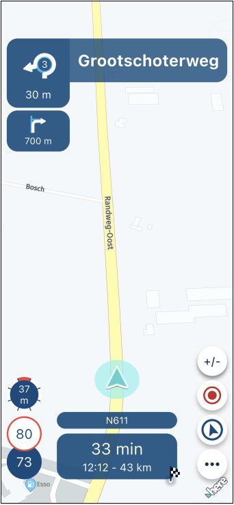
For practice I created a local route on MRA (Basic subscription) using only shaping points and sent it to the Zumo via the Garmin Drive app. Oddly, the Zumo preview showed the last shaping point as a flag as though it was a via point. As a check I saved the route as .gpx 1.1 in MRA, imported it into BaseCamp, and sent it to the Zumo via USB. Once imported by the Zumo, that same shaping point showed properly. Any thoughts as to what's different about MRA? See the screen captures below.
Route in MRA (point 35 is the one in question):

MRA to Zumo, point 35 showing as via/flag:

Route in BaseCamp:

MRA to BaseCamp to Zumo, same point showing as expected shaping point:

-
Warning: Lots of Garmin content.
I recently began experimenting with MRA as a backup route planner while on trips. Up to this point I have used Garmin BaseCamp exclusively and I am very comfortable with its operation.
For practice I created a local route on MRA (Basic subscription) using only shaping points and sent it to the Zumo via the Garmin Drive app. Oddly, the Zumo preview showed the last shaping point as a flag as though it was a via point. As a check I saved the route as .gpx 1.1 in MRA, imported it into BaseCamp, and sent it to the Zumo via USB. Once imported by the Zumo, that same shaping point showed properly. Any thoughts as to what's different about MRA? See the screen captures below.
Route in MRA (point 35 is the one in question):
MRA to Zumo, point 35 showing as via/flag:
Route in BaseCamp:
MRA to BaseCamp to Zumo, same point showing as expected shaping point:
@twinfan on MRA without a subscription, you are working with OSM maps ... Garmin is working with Here maps ! Maybe there is your issue.
Best regards,
AdrianSamsung S24 Ultra and Motorola Thinkphone with Android Auto
MyRoute-APP (Planner+Navigation, GOLD Lifetime)
Honda NC750X (2021) with CHIGEE Aio-5 Play -
Warning: Lots of Garmin content.
I recently began experimenting with MRA as a backup route planner while on trips. Up to this point I have used Garmin BaseCamp exclusively and I am very comfortable with its operation.
For practice I created a local route on MRA (Basic subscription) using only shaping points and sent it to the Zumo via the Garmin Drive app. Oddly, the Zumo preview showed the last shaping point as a flag as though it was a via point. As a check I saved the route as .gpx 1.1 in MRA, imported it into BaseCamp, and sent it to the Zumo via USB. Once imported by the Zumo, that same shaping point showed properly. Any thoughts as to what's different about MRA? See the screen captures below.
Route in MRA (point 35 is the one in question):
MRA to Zumo, point 35 showing as via/flag:
Route in BaseCamp:
MRA to BaseCamp to Zumo, same point showing as expected shaping point:
The dirst and last point are always via points (hard points as in BC) In BC all points are hard points.
-
@twinfan on MRA without a subscription, you are working with OSM maps ... Garmin is working with Here maps ! Maybe there is your issue.
@Adrian-Avram said in Odd MRA treatment of last shaping point:
@twinfan on MRA without a subscription, you are working with OSM maps ... Garmin is working with Here maps ! Maybe there is your issue.
This area is well established and developed so hopefully the maps are close enough not to create an issue.
@Hans-van-de-Ven-MR-MRA said in Odd MRA treatment of last shaping point:
The dirst and last point are always via points (hard points as in BC) In BC all points are hard points.
I know there is some mixing of terms between MRA and BaseCamp. Shouldn't the second to last point (orange flag) then be a "soft" point (shaping point in BaseCamp terms)?
-
@Adrian-Avram said in Odd MRA treatment of last shaping point:
@twinfan on MRA without a subscription, you are working with OSM maps ... Garmin is working with Here maps ! Maybe there is your issue.
This area is well established and developed so hopefully the maps are close enough not to create an issue.
@Hans-van-de-Ven-MR-MRA said in Odd MRA treatment of last shaping point:
The dirst and last point are always via points (hard points as in BC) In BC all points are hard points.
I know there is some mixing of terms between MRA and BaseCamp. Shouldn't the second to last point (orange flag) then be a "soft" point (shaping point in BaseCamp terms)?
@twinfan said in Odd MRA treatment of last shaping point:
@Adrian-Avram said in Odd MRA treatment of last shaping point:
@twinfan on MRA without a subscription, you are working with OSM maps ... Garmin is working with Here maps ! Maybe there is your issue.
This area is well established and developed so hopefully the maps are close enough not to create an issue.
It doesn’t matter how well an area is established or developed, each map has its own set of algorithms and it is these algorithms that dictate which roads are used and why you should use the correct planning map for your device. This is the point that @Adrian-Avram was highlighting.
This will not be the cause of your problem, but I thought I would just mention it. -
Thank you, @Nick-Carthew. I'm well established with BaseCamp but I can see the value in a Gold MRA subscription. I already found a routing problem with OSM while playing with MRA Basic. I would like the confidence of knowing the maps I use for routing are the same regardless of the planning tool.
-
@Adrian-Avram said in Odd MRA treatment of last shaping point:
@twinfan on MRA without a subscription, you are working with OSM maps ... Garmin is working with Here maps ! Maybe there is your issue.
This area is well established and developed so hopefully the maps are close enough not to create an issue.
@Hans-van-de-Ven-MR-MRA said in Odd MRA treatment of last shaping point:
The dirst and last point are always via points (hard points as in BC) In BC all points are hard points.
I know there is some mixing of terms between MRA and BaseCamp. Shouldn't the second to last point (orange flag) then be a "soft" point (shaping point in BaseCamp terms)?
Would you be so kind to share the url of the route, make sure it is set public
-
Hopefully, I've done this correctly:
-
Hopefully, I've done this correctly:
@twinfan
Point 35 is correctly in the gpx file, as a shaping point, why the Zumo shows this as a flag, I dare not say.Point 35 in the BC GPX file:
</rtept>
<rtept lat="38.721981095150113" lon="-121.224045753479">
<time>2025-02-13T07:38:26Z</time>
<name>4306 Old Auburn Rd, Granite Bay, CA 95746-6489, United States</name>
<sym>Flag, Blue</sym>
<extensions>
<trp:ShapingPoint />
gpxx:RoutePointExtension
gpxx:Subclass000000000000FFFFFFFFFFFFFFFFFFFFFFFFFF</gpxx:Subclass>
</gpxx:RoutePointExtension>
</extensions>
</rtept>Point 35 in the MRA GPX file:
<rtept lat="38.721981115079" lon="-121.22404575348">
<name>4306 Old Auburn Rd, Granite Bay, CA 95746-6489, United States</name>
<extensions>trp:ShapingPoint/</extensions>
</rtept>You can see that MRA uses fewer options than BC to compose the GPX file, but that can't be the reason that point 35 is shown as a flag in the Zumo.
I would create a support ticket via the website, so that the developers can look into this.
-
Thank you, @Hans-van-de-Ven-MR-MRA. I only have the Basic subscription for now so am unable to create a support ticket. However, I am also discussing this on the Zumo Users Forum. Many of the experienced Zumo users are also very familiar with MRA.
Hello! It looks like you're interested in this conversation, but you don't have an account yet.
Getting fed up of having to scroll through the same posts each visit? When you register for an account, you'll always come back to exactly where you were before, and choose to be notified of new replies (either via email, or push notification). You'll also be able to save bookmarks and upvote posts to show your appreciation to other community members.
With your input, this post could be even better 💗
Register Login-
013236
-
0391.9k
-
1825.3k
-
0456
-
0354
-
0243
-
014
-
02106