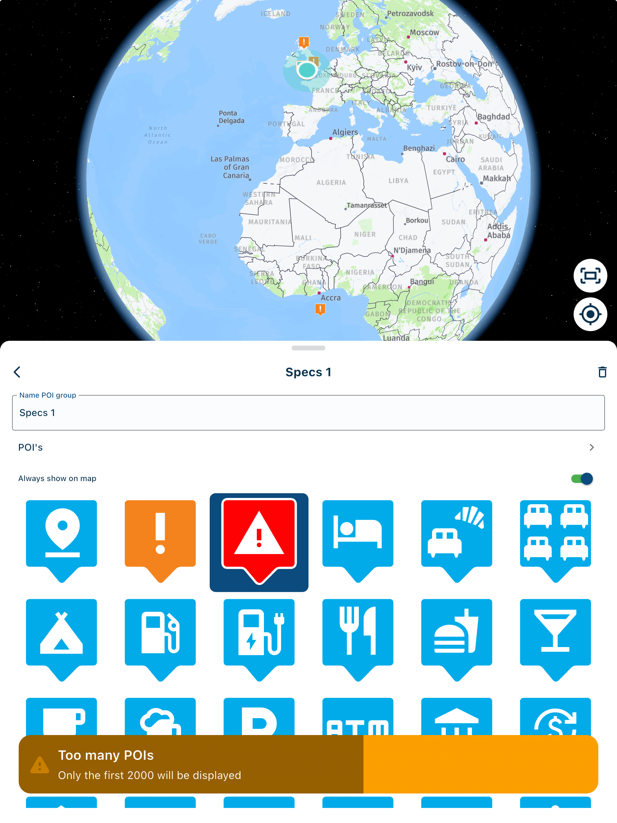
Expert Review of route
-
@Marinus-van-Deudekom Did I mentioned to use 1.2? Don't think so.
@Guzt exactly that would be my advise
I see that you still use Basecamp from way back when. Keep up with up progressive planning of MRA and make the world a bit more beautifull -
@Greenham In the toolkit under optimize you have the possibility to change the route calculation. That option is only available in the HERE map set when you make your route using the car/auto mobile profile.
You can either add a copy of the route (hamburger menu - routes - add) or make the track underlying (which I prefer) visible as reference (I already have an uploaded track of the route as I make all my routes mostly in Basecamp).
When one recalculates with shorter distance e.g. the route will differ from the original. By dragging the recalculated route to the track or reference route, you force the route to follow the original as intended. Hence the reason that one can leave auto-calculation to on on the gps when using gpx 1.11 last question.
What do you do when the tracklog and the route don't line up, but you want to KEEP the route. I can't move the Tracklog to match.
Will the Garmin follow my route or the tracklog?
This is the issue with GPS's and Motorcycles. If you want to take a more scenic route will the GPS let you?
Mike
-
@Greenham The XT has a nasty habbit of thinking it can make a better route then the one you planned. To force the XT to do what YOU want add extra shapingpoints. Use the compare function in the planning mode to see what TomTom and OSM do whit your route. It gives you a small inside of what might happen to your route if you didn't put in enough shapingpoints
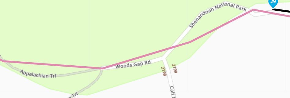
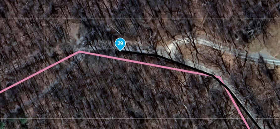
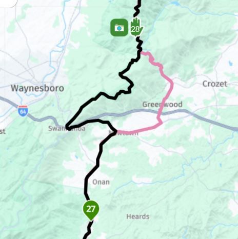
Here is an example of what you are talking about. using @Guzt Workflow and using Tracklogs to compare your DESIRED route to the Tracklog I get these anomalies
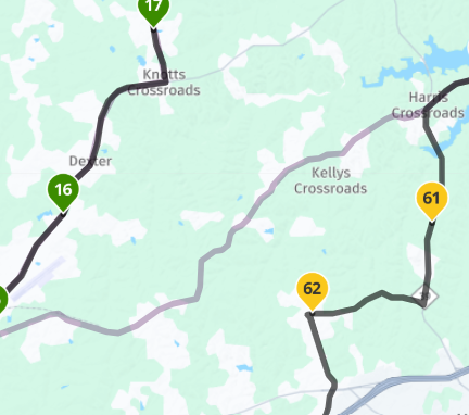
Notice the gray line is the Tracklog the dark line is my preferred route of travel. Will these Tracklogs be the route the Zumo will take me?
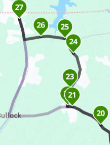
Finally I have this anomaly with a Tracklog/Route comparison.
I've tried all kind of fixes like moving shaping points adding Via points, still get this odd occurrences. The Tracklog is Red, the route is black.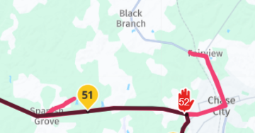
"There is no problem so bad that you can't make it worse"
- Chris Hadfield (NASA Astronaut)
-
Here is an example of what you are talking about. using @Guzt Workflow and using Tracklogs to compare your DESIRED route to the Tracklog I get these anomalies
Notice the gray line is the Tracklog the dark line is my preferred route of travel. Will these Tracklogs be the route the Zumo will take me?
Finally I have this anomaly with a Tracklog/Route comparison.
I've tried all kind of fixes like moving shaping points adding Via points, still get this odd occurrences. The Tracklog is Red, the route is black.@Greenham Did you get those anomalys when switching between shortest en fastest?
That can only be done using the Car profile. In the bike profile you don't have that choise.
For planning I stricktly use the car profile.
I compare the prefered route (planned in the Here map) with the TomTom and OSM maps and make shure adding extra shaping points to the route when there's an anomaly. Then in the end when I'm satisfied and the 3 maps are alike I transfer the route to the XT, using the Drive app.
I don't use any avoid items in the planner and I dopn't use any in the XT. That way the route stays the same. Make sure that recalculating in your XT is OFF.
Why: although there's a lot of different opinions on this theme, if you deviate from the route, let's say there's roadworks going on and the route is blocked, and you have recalculate ON, the XT will break free from its harness, the route, and grab it's change to change your route. There's a 100% garantee that it will mess up your rouite.
If you want us to say something about the anomalys you've mentioned, share such a route here and make shure it's set to public.
have funHonda Goldwing GL1500,
Honda Silverwing GL 650
DMD2 T865X 8 inch Android tablet using MRA next for navigation
Garmin XT sold
Samsung S24FE mounted on a Quadlock and using Android Auto in my car -
@Greenham Did you get those anomalys when switching between shortest en fastest?
That can only be done using the Car profile. In the bike profile you don't have that choise.
For planning I stricktly use the car profile.
I compare the prefered route (planned in the Here map) with the TomTom and OSM maps and make shure adding extra shaping points to the route when there's an anomaly. Then in the end when I'm satisfied and the 3 maps are alike I transfer the route to the XT, using the Drive app.
I don't use any avoid items in the planner and I dopn't use any in the XT. That way the route stays the same. Make sure that recalculating in your XT is OFF.
Why: although there's a lot of different opinions on this theme, if you deviate from the route, let's say there's roadworks going on and the route is blocked, and you have recalculate ON, the XT will break free from its harness, the route, and grab it's change to change your route. There's a 100% garantee that it will mess up your rouite.
If you want us to say something about the anomalys you've mentioned, share such a route here and make shure it's set to public.
have fun@Marinus-van-Deudekom said in Expert Review of route:
@Greenham Did you get those anomalys when switching between shortest en fastest?
That can only be done using the Car profile. In the bike profile you don't have that choise.
For planning I stricktly use the car profile.
I compare the prefered route (planned in the Here map) with the TomTom and OSM maps and make shure adding extra shaping points to the route when there's an anomaly. Then in the end when I'm satisfied and the 3 maps are alike I transfer the route to the XT, using the Drive app.
I don't use any avoid items in the planner and I dopn't use any in the XT. That way the route stays the same. Make sure that recalculating in your XT is OFF.
Why: although there's a lot of different opinions on this theme, if you deviate from the route, let's say there's roadworks going on and the route is blocked, and you have recalculate ON, the XT will break free from its harness, the route, and grab it's change to change your route. There's a 100% garantee that it will mess up your rouite.
If you want us to say something about the anomalys you've mentioned, share such a route here and make shure it's set to public.
have funIt's the only route (So far) that has done this. I do your the CAR profile, I don't use any avoidances. I downloaded the tracklog at @Guzt outlined in his paper, then compared with both the fastest and shortest comparisons.
Thanks for your thoughts.
Mike
."There is no problem so bad that you can't make it worse"
- Chris Hadfield (NASA Astronaut)
-
@Marinus-van-Deudekom said in Expert Review of route:
@Greenham Did you get those anomalys when switching between shortest en fastest?
That can only be done using the Car profile. In the bike profile you don't have that choise.
For planning I stricktly use the car profile.
I compare the prefered route (planned in the Here map) with the TomTom and OSM maps and make shure adding extra shaping points to the route when there's an anomaly. Then in the end when I'm satisfied and the 3 maps are alike I transfer the route to the XT, using the Drive app.
I don't use any avoid items in the planner and I dopn't use any in the XT. That way the route stays the same. Make sure that recalculating in your XT is OFF.
Why: although there's a lot of different opinions on this theme, if you deviate from the route, let's say there's roadworks going on and the route is blocked, and you have recalculate ON, the XT will break free from its harness, the route, and grab it's change to change your route. There's a 100% garantee that it will mess up your rouite.
If you want us to say something about the anomalys you've mentioned, share such a route here and make shure it's set to public.
have funIt's the only route (So far) that has done this. I do your the CAR profile, I don't use any avoidances. I downloaded the tracklog at @Guzt outlined in his paper, then compared with both the fastest and shortest comparisons.
Thanks for your thoughts.
Mike
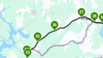
.@Greenham I find it very strange that the saved and imported track differs from your initialy desired route. MRA is not always 100% accurate when exporting the track and can have some undesired peak paths which one should ignore. (Sometimes when I import a BC track, the stranges things happen).
I imported your route, saved it as a track and imported this track in my tracklogs
[link text]https://www.myrouteapp.com/nl/social/track/707609?mode=share(link url)
Went back to the route and and made the track visible. Lowered the routing points to 20 and adjusted the route to the track (The blue routing numbers). Recalculated with shortest distance and adjusted the route to the track. Switched back to fastest distance and changed the map set to TT. Problems occured after routing point 29 where there is no road any more but a trail. So on the TT map the route is no longer following the track but redirected.
[link text]https://www.myrouteapp.com/profile/routes/17526#options-route-social(link url)
For the rest I had no problems at all to optimize your route.!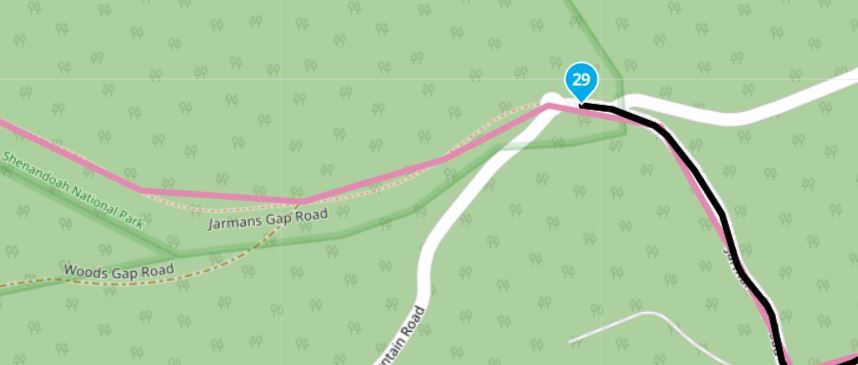
Hello! It looks like you're interested in this conversation, but you don't have an account yet.
Getting fed up of having to scroll through the same posts each visit? When you register for an account, you'll always come back to exactly where you were before, and choose to be notified of new replies (either via email, or push notification). You'll also be able to save bookmarks and upvote posts to show your appreciation to other community members.
With your input, this post could be even better 💗
Register Login-
1936.3k
-
0468
-
014220
-
0257
-
17438.7k
-
255613.0k
-
0948
-
04155