BMW Connected Ride Navigator not importing waypoints
-
If I create a route in MRA, no matter what format I save it or what map I use when imported into my BMW Connected Ride Navigator it doesn't recognise the waypoints. It calls them "support points" which seems to acknowledge them when calculating the route but then doesn't show them along the route. I've retried other gpx files from other route planners and these are fine so it must be how I'm creating/saving them in MRA. I've seen some advice where I can convert the imported routes to waypoints by using the Connected Ride App on my phone but then it defeats the object of me having a separate sat nav as there's no option on there. I've also noticed the gpx file created from MRA is a lot smaller in size compared to other route planners so again, I'm thinking it must be what I'm doing in MRA that's the problem.
Any advice or info welcomed!
Cheers -
If I create a route in MRA, no matter what format I save it or what map I use when imported into my BMW Connected Ride Navigator it doesn't recognise the waypoints. It calls them "support points" which seems to acknowledge them when calculating the route but then doesn't show them along the route. I've retried other gpx files from other route planners and these are fine so it must be how I'm creating/saving them in MRA. I've seen some advice where I can convert the imported routes to waypoints by using the Connected Ride App on my phone but then it defeats the object of me having a separate sat nav as there's no option on there. I've also noticed the gpx file created from MRA is a lot smaller in size compared to other route planners so again, I'm thinking it must be what I'm doing in MRA that's the problem.
Any advice or info welcomed!
CheersUse the TomTom map, use max 50 shaping points. Then send it to the connected app, choose the track and route with 50 points.
Then in the route file tick on the 3 dots in the upper right corner and choose convert to route with points. The 50 points will be visible.
Choose that route on the CRN and you can also make the track visible on the CRNGarmin Zumo XT3/XT2/XT/BMW Connected Ride Navigator/Tourstart/ MyRouteapp (The App)/...
Een dag niet gelachen is een dag niet geleefd / Een route is net zo goed als deze uitgezet is. -
hi @Topcat502
i draw your attention to this thread which is on the K1600 forum, it is very informative,
i think he wrote on here but i cannot find it, hope the above helps.
it looks long winded but in reality it is not,
i would like to add the above link explains how to import routes from MRA in to the connected app
-
Use the TomTom map, use max 50 shaping points. Then send it to the connected app, choose the track and route with 50 points.
Then in the route file tick on the 3 dots in the upper right corner and choose convert to route with points. The 50 points will be visible.
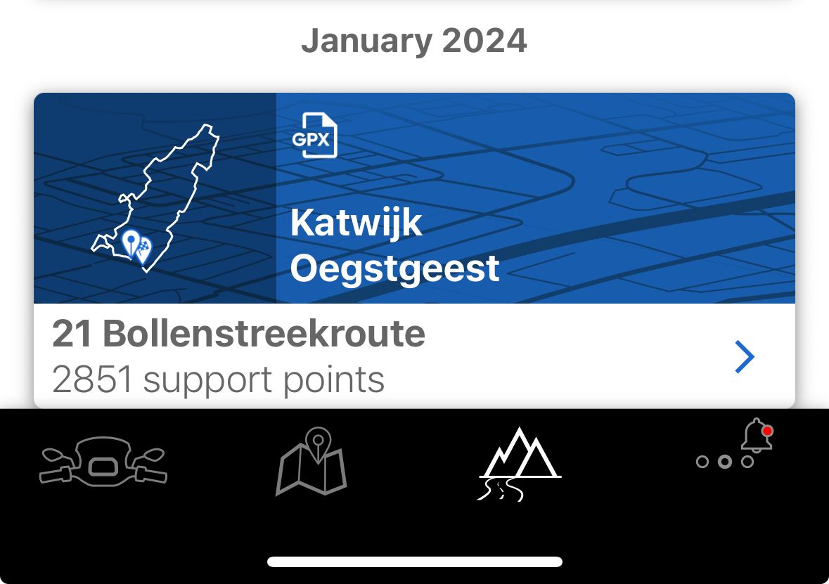
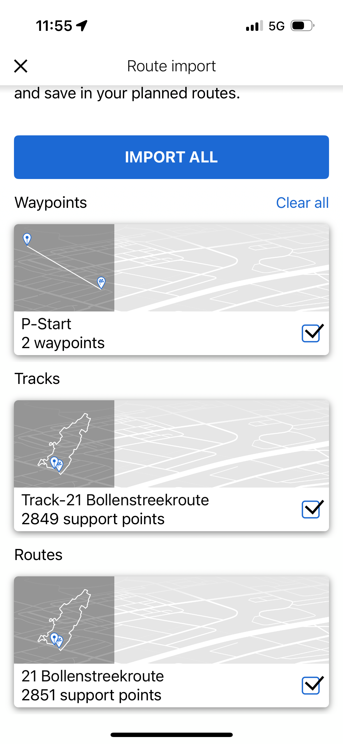
Choose that route on the CRN and you can also make the track visible on the CRN@Hans-van-de-Ven-MR-MRA How do I control the number of shaping points? For example if I pick a public route like this (https://www.myrouteapp.com/en/motor-and-car-routes/nl/Noord-Holland/295532/21-Bollenstreekroute), this shows up as 2851 support points in the Connected App and Navigator. There's only 32 actual waypoints in the route.
I'm just so confused by this BMW Connected App/Navigator. I only want the waypoints to show up and I don't really care about the exact route, as long as it's an approximation.
-
@Hans-van-de-Ven-MR-MRA How do I control the number of shaping points? For example if I pick a public route like this (https://www.myrouteapp.com/en/motor-and-car-routes/nl/Noord-Holland/295532/21-Bollenstreekroute), this shows up as 2851 support points in the Connected App and Navigator. There's only 32 actual waypoints in the route.
I'm just so confused by this BMW Connected App/Navigator. I only want the waypoints to show up and I don't really care about the exact route, as long as it's an approximation.
that to me looks like you have imported the track and not the route/waypoints.
i doubt anyone would plan a route with 2800 waypoints, that would be excessive in my viewsomebody may correct me on this fact.
did you read the post i inserted above.
to achieve, we must first attempt ✌️
K1600 GTL
Oukitel RT3
iPhone 13 Pro, carpuride 702b -
that to me looks like you have imported the track and not the route/waypoints.
i doubt anyone would plan a route with 2800 waypoints, that would be excessive in my viewsomebody may correct me on this fact.
did you read the post i inserted above.
@paul69 I imported the route. However there is little difference in the route vs track when it comes to support points. Importing the waypoints alone gives me just a straight line between the start and the end.
-
@paul69 I imported the route. However there is little difference in the route vs track when it comes to support points. Importing the waypoints alone gives me just a straight line between the start and the end.
@Philip-Goh
The 2 points are the via points in the route, don’t use this routeThe other 2 you can use, the one with more then 1000 start porting points is the track
The other one is the routeGarmin Zumo XT3/XT2/XT/BMW Connected Ride Navigator/Tourstart/ MyRouteapp (The App)/...
Een dag niet gelachen is een dag niet geleefd / Een route is net zo goed als deze uitgezet is. -
@Philip-Goh
The 2 points are the via points in the route, don’t use this routeThe other 2 you can use, the one with more then 1000 start porting points is the track
The other one is the route@Hans-van-de-Ven-MR-MRA So the one that is the "route" with the 2851 support points i the one I want while the "track" with 2849 support points is the one I want to avoid?
-
Use the TomTom map, use max 50 shaping points. Then send it to the connected app, choose the track and route with 50 points.
Then in the route file tick on the 3 dots in the upper right corner and choose convert to route with points. The 50 points will be visible.
Choose that route on the CRN and you can also make the track visible on the CRN@Hans-van-de-Ven-MR-MRA said in BMW Connected Ride Navigator not importing waypoints:
Use the TomTom map, use max 50 shaping points. Then send it to the connected app, choose the track and route with 50 points.
Then in the route file tick on the 3 dots in the upper right corner and choose convert to route with points. The 50 points will be visible.
Choose that route on the CRN and you can also make the track visible on the CRNSuperbedankt Hans. Op die manier worden er inderdaad punten zichtbaar. Ik heb niet het idee overigens dat dit de punten zijn die ik in MRA heb aangemaakt. Dus een lunchstop of koffiestop heeft mogelijk geen punt in de CRN.
Heb je misschien daar weer een oplossing voor?
BMW R1300 GS, BMW Connect Ride Next navigator; Quad Lock with Samsung Galaxy Ultra, iPad Pro (iPadOS 18.0 bèta version) MacBook Pro (MacOS Sequoia 15.2 bèta version), iMac (MacOS Monterey 12.7.6)
-
@paul69 I imported the route. However there is little difference in the route vs track when it comes to support points. Importing the waypoints alone gives me just a straight line between the start and the end.
This is also what I see when exporting from MRA to the Connect Ride app on my iPhone WHEN I EXPORT the route as a GPX1.2 file. When exporting as a GPX1.1 file, the number of point in the route are always below 50.
Like the Track, also the route with the many points (sometimes >3000) can be used by the CRN!
BMW R1300 GS, BMW Connect Ride Next navigator; Quad Lock with Samsung Galaxy Ultra, iPad Pro (iPadOS 18.0 bèta version) MacBook Pro (MacOS Sequoia 15.2 bèta version), iMac (MacOS Monterey 12.7.6)
-
@Hans-van-de-Ven-MR-MRA said in BMW Connected Ride Navigator not importing waypoints:
Use the TomTom map, use max 50 shaping points. Then send it to the connected app, choose the track and route with 50 points.
Then in the route file tick on the 3 dots in the upper right corner and choose convert to route with points. The 50 points will be visible.
Choose that route on the CRN and you can also make the track visible on the CRNSuperbedankt Hans. Op die manier worden er inderdaad punten zichtbaar. Ik heb niet het idee overigens dat dit de punten zijn die ik in MRA heb aangemaakt. Dus een lunchstop of koffiestop heeft mogelijk geen punt in de CRN.
Heb je misschien daar weer een oplossing voor?
Klopt TT kent geen via punten of harde punten. De route splitsen bij de koffie, lunchstop is een optie
-
@paul69 I imported the route. However there is little difference in the route vs track when it comes to support points. Importing the waypoints alone gives me just a straight line between the start and the end.
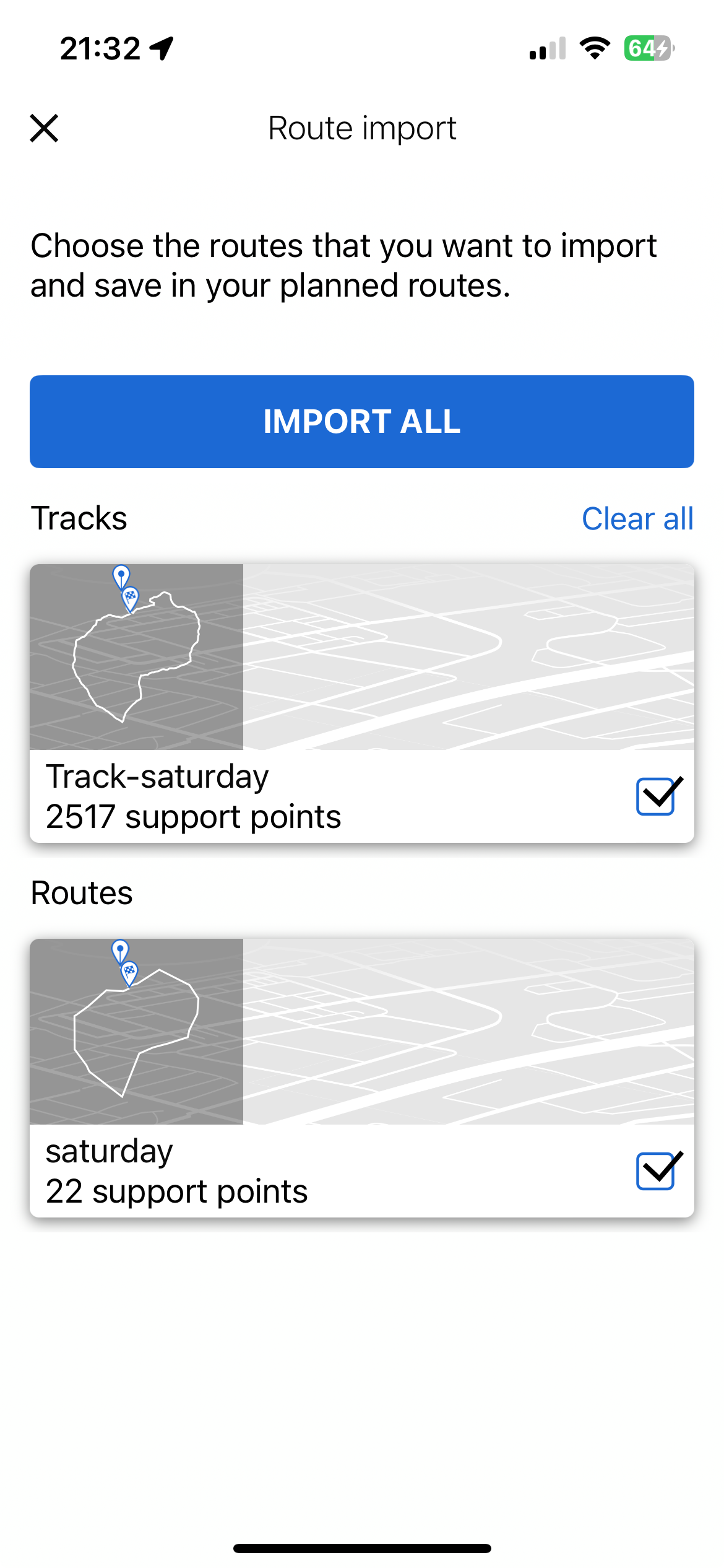
i have just exported a simple route from MRA to my connected app, if you notice the two are very different, one has 2517 support points and the other only 22. obviously the lower number is the route with the waypoints.
perhaps you should try to import again and see if you get the same result
i cannot explain why you would have so many way/support points in a route.
-
@paul69 I imported the route. However there is little difference in the route vs track when it comes to support points. Importing the waypoints alone gives me just a straight line between the start and the end.
i have downloaded the same route as the one you used, i do not seem to be having the issue that you have
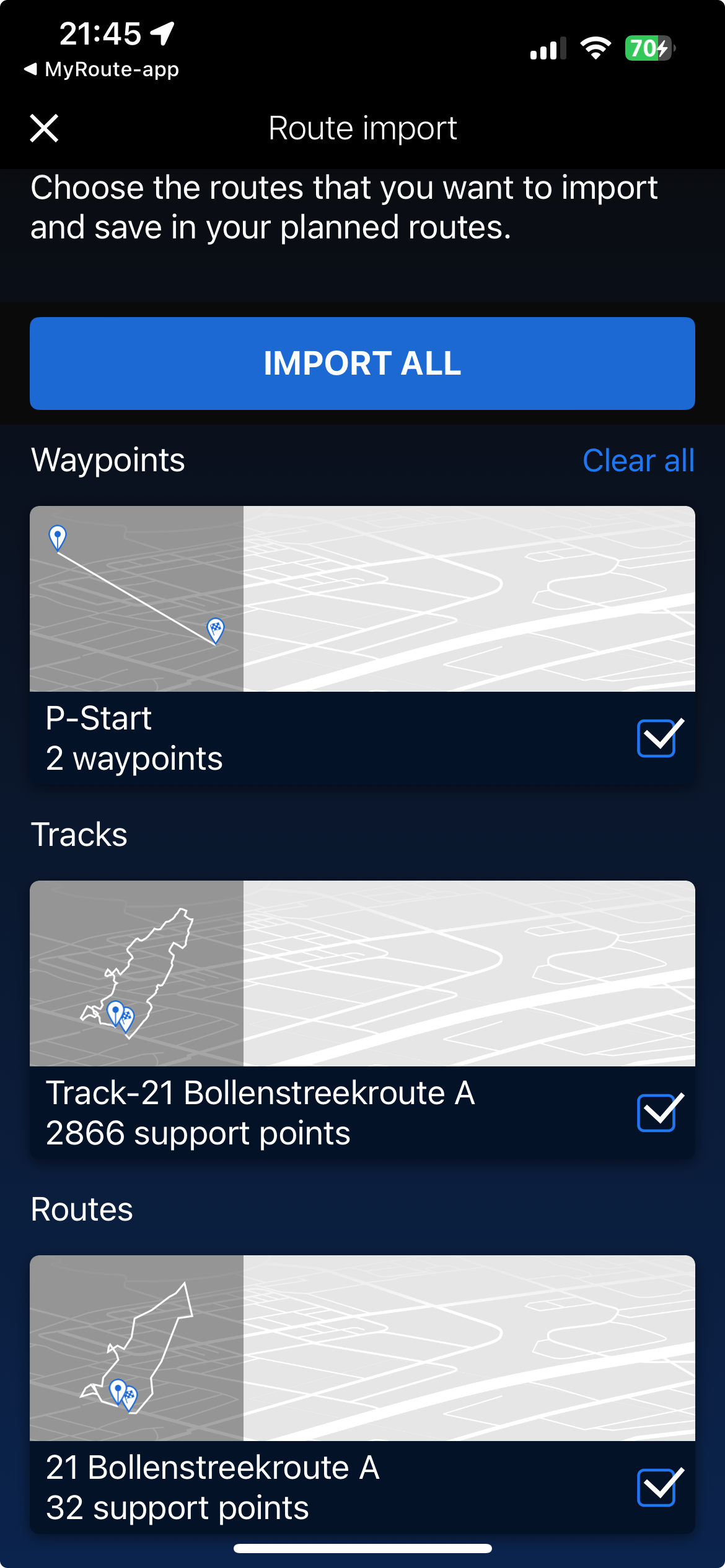
as you can see i have something similar to you except my route only shows 32 support points.
i have added a capital A to the name just for reference.
this was in the mRA app on my iPhone.
the route saved in my routes on the website,MRA app>click route> click download as 1.1gpx>then click export>click connected app>this gives the above page>select route to import.
-
This is also what I see when exporting from MRA to the Connect Ride app on my iPhone WHEN I EXPORT the route as a GPX1.2 file. When exporting as a GPX1.1 file, the number of point in the route are always below 50.
Like the Track, also the route with the many points (sometimes >3000) can be used by the CRN!
@Dikke-Wim This was it!! I was always using GPX 1.2 and that seems to generate files that are 2x the size of the GPX 1.1 files. When I switch to using GPX 1.1, then it works as expected!
GPX 1.1 is the way to go for BMW’s connected ride app and navigator.
-
@Dikke-Wim This was it!! I was always using GPX 1.2 and that seems to generate files that are 2x the size of the GPX 1.1 files. When I switch to using GPX 1.1, then it works as expected!
GPX 1.1 is the way to go for BMW’s connected ride app and navigator.
@Philip-Goh said in BMW Connected Ride Navigator not importing waypoints:
@Dikke-Wim This was it!! I was always using GPX 1.2 and that seems to generate files that are 2x the size of the GPX 1.1 files. When I switch to using GPX 1.1, then it works as expected!
GPX 1.1 is the way to go for BMW’s connected ride app and navigator.
Exctually, I'm not sure yet that GPX1.1 is the best option. If I look at the ROUTE in the pictures above, I see differences between the route and the Track.
A good check is to:
- make the track visible (e.g. in the color black instead of the default white color)
- then start the route with the fewer waypoints (<50)
- compare the route with the tack on the map.
- differences are easily seen when the blue line (route) deviates from the black line (track).
I'm curious about the result.
Please let me know the outcome!BMW R1300 GS, BMW Connect Ride Next navigator; Quad Lock with Samsung Galaxy Ultra, iPad Pro (iPadOS 18.0 bèta version) MacBook Pro (MacOS Sequoia 15.2 bèta version), iMac (MacOS Monterey 12.7.6)
-
@Philip-Goh said in BMW Connected Ride Navigator not importing waypoints:
@Dikke-Wim This was it!! I was always using GPX 1.2 and that seems to generate files that are 2x the size of the GPX 1.1 files. When I switch to using GPX 1.1, then it works as expected!
GPX 1.1 is the way to go for BMW’s connected ride app and navigator.
Exctually, I'm not sure yet that GPX1.1 is the best option. If I look at the ROUTE in the pictures above, I see differences between the route and the Track.
A good check is to:
- make the track visible (e.g. in the color black instead of the default white color)
- then start the route with the fewer waypoints (<50)
- compare the route with the tack on the map.
- differences are easily seen when the blue line (route) deviates from the black line (track).
I'm curious about the result.
Please let me know the outcome!@Dikke-Wim you have to do what Hans suggested above, which is to take the route, convert it to a set of waypoints and then the route looks very similar to the track. Much better than what was in the screenshot.
-
@Dikke-Wim you have to do what Hans suggested above, which is to take the route, convert it to a set of waypoints and then the route looks very similar to the track. Much better than what was in the screenshot.
Thanks for adding this information. Very useful.
Indeed, the route becomes much better and similar to the track after calculating the routepoints in de Connect Ride App on the smartphone. Once inside the Connect Ride Next it looks good!
So the small image of the route in de App is misleading.
BMW R1300 GS, BMW Connect Ride Next navigator; Quad Lock with Samsung Galaxy Ultra, iPad Pro (iPadOS 18.0 bèta version) MacBook Pro (MacOS Sequoia 15.2 bèta version), iMac (MacOS Monterey 12.7.6)
-
Thanks for adding this information. Very useful.
Indeed, the route becomes much better and similar to the track after calculating the routepoints in de Connect Ride App on the smartphone. Once inside the Connect Ride Next it looks good!
So the small image of the route in de App is misleading.
@Dikke-Wim said in BMW Connected Ride Navigator not importing waypoints:
Thanks for adding this information. Very useful.
Indeed, the route becomes much better and similar to the track after calculating the routepoints in de Connect Ride App on the smartphone. Once inside the Connect Ride Next it looks good!
So the small image of the route in de App is misleading.and that is exactly the information given in the link i posted at the beginning of this thread.
to achieve, we must first attempt ✌️
K1600 GTL
Oukitel RT3
iPhone 13 Pro, carpuride 702b -
@Dikke-Wim said in BMW Connected Ride Navigator not importing waypoints:
Thanks for adding this information. Very useful.
Indeed, the route becomes much better and similar to the track after calculating the routepoints in de Connect Ride App on the smartphone. Once inside the Connect Ride Next it looks good!
So the small image of the route in de App is misleading.and that is exactly the information given in the link i posted at the beginning of this thread.
Sometimes I'm hard learning...
")
BMW R1300 GS, BMW Connect Ride Next navigator; Quad Lock with Samsung Galaxy Ultra, iPad Pro (iPadOS 18.0 bèta version) MacBook Pro (MacOS Sequoia 15.2 bèta version), iMac (MacOS Monterey 12.7.6)
-
@Dikke-Wim said in BMW Connected Ride Navigator not importing waypoints:
Sometimes I'm hard learning...
hi
did you look at the thread I inserted. although it's a different forum.
I have actually copied into pdf doc and have easy access to it, for when i forget how to do it.to achieve, we must first attempt ✌️
K1600 GTL
Oukitel RT3
iPhone 13 Pro, carpuride 702b
Hello! It looks like you're interested in this conversation, but you don't have an account yet.
Getting fed up of having to scroll through the same posts each visit? When you register for an account, you'll always come back to exactly where you were before, and choose to be notified of new replies (either via email, or push notification). You'll also be able to save bookmarks and upvote posts to show your appreciation to other community members.
With your input, this post could be even better 💗
Register Login-
18103
-
010215
-
17142
-
310264
-
012308
-
06187
-
0549
-
0249