Suggestion based on what I saw in REVER
-
Hi, love the webapp and I have been using it for years to plan my Motorcycle trips. Recently someone showed me REVER. I wasn't that impressed and IMO I think MyRoute has a better and faster interface. One feature I did like was the Butler Map integration. I was wondering if that would be possible to add as an option (and yes I understand it would cost more).
Thank you
Ron G - Mtl Qc. Canada
@Ron-Gardiner I think that's a great idea.
-
Hi, love the webapp and I have been using it for years to plan my Motorcycle trips. Recently someone showed me REVER. I wasn't that impressed and IMO I think MyRoute has a better and faster interface. One feature I did like was the Butler Map integration. I was wondering if that would be possible to add as an option (and yes I understand it would cost more).
Thank you
Ron G - Mtl Qc. Canada
@Ron-Gardiner said in Suggestion based on what I saw in REVER:
I had to search a bit to find out what that Butler card can do for me.
If I see it correctly on Rever's site, you have to purchase the Pro version and it costs $39.95. Is that right??
Would you also be willing to pay for that at MRA?
I think it's a really nice addition. But wouldn't buy it as an extra -
Hi, love the webapp and I have been using it for years to plan my Motorcycle trips. Recently someone showed me REVER. I wasn't that impressed and IMO I think MyRoute has a better and faster interface. One feature I did like was the Butler Map integration. I was wondering if that would be possible to add as an option (and yes I understand it would cost more).
Thank you
Ron G - Mtl Qc. Canada
@Ron-Gardiner My wife and I planned a 8000 mile 'bucket list' trip last year. I used MRA to route our travel over 30 days. Each day was downloaded to my Zumo XT.
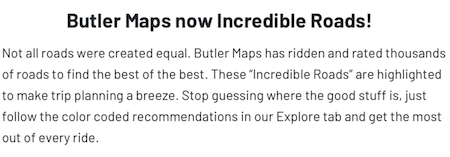
As part of our planning, I did buy a subscription to the Butler map option in REVER. I found it somewhat helpful in identifying popular roads. I saw that most routes were short duration, or day trips. We were trying to find the most scenic route through a state on the way to a more distant destination.
So the Rever maps were not a big factor in our planning, even though they were paid for. I found I was much more productive using MRA for routing. Rever / Butler maps were just another way of identifying points of interest, along with paper maps and rider reports.
If I could see Butler maps as an overlay in MRA, I would probably spend the $40 (again). Anything that can be displayed (or turned off) in the MRA workspace would add value to my routing time.
I'll mention another feature that I would buy for a reasonable price.
I believe that another post mentioned an interactive Google map option. I am a MRA gold member, and use the Google map almost exclusively. It shows me exact road names with less zooming in and out than the other map displays. My workflow usually involves a second open window with an actual Google map session open. On that map I can then click on icons for restaurants and hotels, and learn more about their business. Being able to do this within MRA would be a huge time saver!As a side note, I would like to say that I don't know how I would manage a long trip without MRA. It's a lot of work to build long routes with many stops, and for me MRA has been the best way to get that work done. My thanks to all involved in developing and supporting this great application!
-
@Ron-Gardiner My wife and I planned a 8000 mile 'bucket list' trip last year. I used MRA to route our travel over 30 days. Each day was downloaded to my Zumo XT.
As part of our planning, I did buy a subscription to the Butler map option in REVER. I found it somewhat helpful in identifying popular roads. I saw that most routes were short duration, or day trips. We were trying to find the most scenic route through a state on the way to a more distant destination.
So the Rever maps were not a big factor in our planning, even though they were paid for. I found I was much more productive using MRA for routing. Rever / Butler maps were just another way of identifying points of interest, along with paper maps and rider reports.
If I could see Butler maps as an overlay in MRA, I would probably spend the $40 (again). Anything that can be displayed (or turned off) in the MRA workspace would add value to my routing time.
I'll mention another feature that I would buy for a reasonable price.
I believe that another post mentioned an interactive Google map option. I am a MRA gold member, and use the Google map almost exclusively. It shows me exact road names with less zooming in and out than the other map displays. My workflow usually involves a second open window with an actual Google map session open. On that map I can then click on icons for restaurants and hotels, and learn more about their business. Being able to do this within MRA would be a huge time saver!As a side note, I would like to say that I don't know how I would manage a long trip without MRA. It's a lot of work to build long routes with many stops, and for me MRA has been the best way to get that work done. My thanks to all involved in developing and supporting this great application!
@Don-Stauffer said in Suggestion based on what I saw in REVER:
I found it somewhat helpful in identifying popular roads.
In the MRA routeplanner I use the michelin map overlay (and the green marked roads) for this. It works very well for Europe but I don't know about the rest of the world.
Hello! It looks like you're interested in this conversation, but you don't have an account yet.
Getting fed up of having to scroll through the same posts each visit? When you register for an account, you'll always come back to exactly where you were before, and choose to be notified of new replies (either via email, or push notification). You'll also be able to save bookmarks and upvote posts to show your appreciation to other community members.
With your input, this post could be even better 💗
Register Login-
0936
-
09177
-
06111
-
08118
-
7281.7k
-
04178
-
0222
-
36211