Duelling Banjos with MyRouteApp
-
Hi,
As you may know I've been travelling throughout mainland Europe recently with a mate - Mike.
To ensure that we followed exactly the same route, Mike and I both subscribed to the new app as lifetime members. I also have RouteLab lifetime gold.
I use Android, Mike is on ios. However, I made sure that we were on the same app release (4.02 - 203) had the same map download release, and the same functional settings - see attachment.
I set a daily route and shared it with Mike via WhatsApp link. This works great initially.
We suffered a number of points however, where our SatNavs disagreed on the route - minor at first, then ...
See pic attached. My planned route was to make a sharp left at the circled point, headed for the numbered shaping points.
As we approached the junction, Mike stopped me as his Mra nav was pointing straight on!
This would mean skipping a number of the shaping points - and the interesting route I had planned.
I find it disconcerting that despite our best efforts to create a unified route, we keep having to stop to discuss differences - minor and major.
Am I missing something in the setup? Are we able to correct this, and drive a single agreed route?
Any help gratefully appreciated ...
Note : Am unable to send an image from my phone screen, but here's the route link ...
https://www.myrouteapp.com/route/open/7810275
The turn I referred to is early in the route - on the D618 just before Camors.
My Nav wanted to follow the set route via the shaping points. Mike's wanted to send him straight on via Avajan etc and skipping multiple shaping points. -
@Jem-Cotton I don't see any attached image with a circled point. It might be helpful to include it to accurately determine where the issue is occurring for you. Generally, I do notice that some waypoints are completely off the road. Make sure to place all the waypoints in the middle of the road at the very least. Ideally, place them directly on the route line. You can achieve this by zooming in as much as possible on each waypoint.
If it's only happening at the beginning, then it's very simple: add an extra waypoint on the D618 just after the exit.
In fact, I always place waypoints at significant course changes. -
@Rob-Verhoeff Hi Rob.
I'd love to upload a screenshot but can't work out how. However, the linked route and description gives the necessary info ...
... or if you can point to how to attach an image using my phone ...
-
-
@Jem-Cotton Actually, you already have my answer. As soon as the D618 starts, place a waypoint there. This applies to other points in your route where the route sharply turns or transitions from a main road to a smaller secondary road. And make sure to place all waypoints directly on the route line!
-
@StefanHummelink Hi Stefan. Thanks.
The button was hidden off screen. Tried it twice buy it just crashes the forum and my app shuts down. Duh!
Will keep trying
-
@Jem-Cotton, This is not where it went wrong for you but I am taking this as an example:
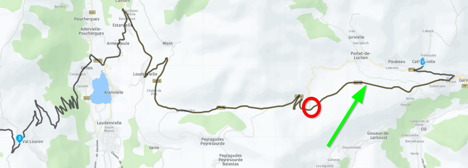
You have a distance of 25km between wp1 and 2. The difference in distance and/or time between taking the D76 and the D618 to the red circle marked crossing is marginal. That leaves interpretation to the route calculation engine to take either. Based on trafic info for example. I would have placed an extra WP at the green arrow, to force that part of the route.
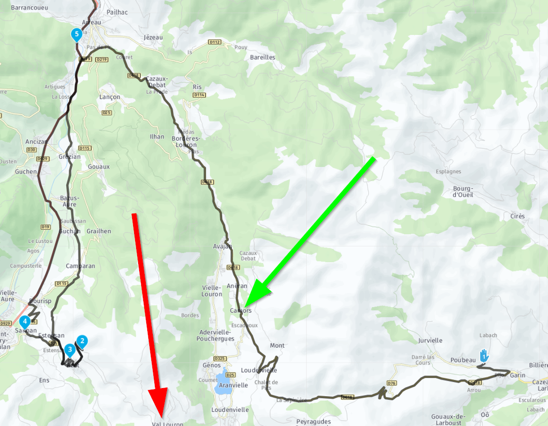
Taking the D618 up North from Camors looks like multiple waypoints are being skipped, but that is actually not true. Only skipping WP2 already leads to taking the long way up north, probably because of the very slow interesting route you made, but with not enough waypoints

The green arrow shows where you deviated. The red arrow shows the location of WP2 being skipped. The route engine says it is faster to go up North to (originally) WP3 instead of South like you intended.
Why WP2 got skipped before it was reached, I don't know. Could be by accident, pressing on the upper right tile. But there are also a few posts about premature skipping of waypoints. But I have not experienced that myself yet.
It is not uncommon to add shaping points at every 2 to 10 km. But more important is it to check your route for possible alternative calculations, like depicted in my first picture.
-
@Con-Hennekens @Jem-Cotton And that brings me exactly to my point of placing a waypoint after every important intersection or road split, at the very least. You can easily skip a 40km stretch without a waypoint, especially when the route winds through the mountains with no side roads.
-
@Rob-Verhoeff said in Duelling Banjos with MyRouteApp:
You can easily skip a 40km stretch without a waypoint, especially when the route winds through the mountains with no side roads.
Yes you can indeed. There are not much alternatives if there are no side roads
 . But the further the waypoints are apart, the more impact skipping a waypoint can have. That's what we are seeing here.
 -
Hi all,
I understand about the placement of waypoints, but that doesn't address the main point of my issue which is ..
Why would 2 MRA apps with the same version and same downloaded maps, and sharing exactly the same route ... make different route choices?
Cheers, Jem
-
@Jem-Cotton said in Duelling Banjos with MyRouteApp:
the same functional settings
Did you look at the setting that are shown in the first screen after opening a route for navigation too?
-
@Jem-Cotton said in Duelling Banjos with MyRouteApp:
I understand about the placement of waypoints, but that doesn't address the main point
I think it does... Obviously your pal Mike skipped WP2 somehow. Be it by an unintended manual skip, or by a premature skipping by the app itself. Long-pressing WP2 would have put you in the same direction again. My pictures above illustrate that skipping only WP2 has the effect you experienced.
-
@Jack-van-Tilburg, Those settings are deemed to be equal for them both, since they are inherited from the online route nowadays. Unless they were altered manually before starting the route of course.
-
@Con-Hennekens
So is a difference ruled out? -
@Jack-van-Tilburg, if not altered manually at the location you show, I think yes.
If the impact of the routing options was that big, it would already be visible in the route overview window where you press Start too.Doesn't my explanation above sound more plausible, you think?
-
@Con-Hennekens said in Duelling Banjos with MyRouteApp:
Doesn't my explanation above sound more plausible, you think?
Yes it does. More then mine i should say.
But even your option doesn't exclude un unintended action of the user. -
@Jack-van-Tilburg, certainly not indeed.
-
All your points are plain 'waypoints' / shaping points, which means they're not mandatory and can be skipped, should the routing engine dynamically decide it knows better.
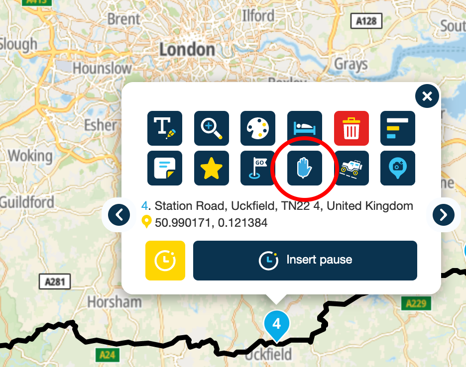
Change one (or more) of the waypoints - say point 3 - to a 'via' point, i.e. a point that you must pass through. Then the routing engine should behave as you expect.
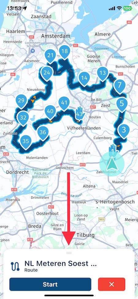
You can do that by tapping on the hand symbol (possibly teaching Grandma to suck eggs, here - sorry!):
I think the only downside to via points is if there's a road closure, serious traffic problem, etc, it will still attempt to get you to go through that 'via' point, which could cause some interesting routing.
For example if the road was closed a mile after your point 2 then the routing engine would do some complex re-routing to make sure you still got to point 3, whereas in real life, you might just think - 'forget it, let's go another route today'.All that fluff above doesn't explain why both instances of the app didn't behave in a similar manner, but it might help get them better aligned next time.

-
@richtea999, It seems I keep repeating myself, but my pictures above show that even if WP3 was a viapoint, by skipping WP2 the navigation would take the long way up north to WP3 because it is quicker than the winding roads down south.
Via points are used to indicate mandatory waypoints, nothing more. The ultimate reason why the deviation after skipping WP2 is so big, is that there are not enough shaping points in the route to force it down south.
-
@Con-Hennekens You're right, Con - apologies. I have had similar oddities that seem to have been solved by using 'via' points. Maybe that was just luck.
Maybe the route planner needs an extra option:
- calculate shortest route
