New Beta! (v3.2.16)
-
A big congratulations for the work accomplished in such a short time.
One more small step on offline research and free navigation and my zumo 660 will be only a memory...It's amazing what you have achieved !
-
Nog even en mijn Garmin zumo XT kan de kast in.

Ziet er goed uit.@Albert-van-den-Elsen mijn TomTom er ook afgehaald ondertussen
🏍️ Tiger: DMD Nor7e + SilverFox controller
🏍️ Bobber: iPhone 15 Pro + Quad Lock mount
🚗 Car: iPhone 15 Pro with wireless Apple CarPlay -
Hey everyone!

Today is the day for another big update! We've fixed the most crucial issue in the app and added / tweaked a lot of functionalities! We're pretty sure that you will be very pleased with this update

It will be available somewhere between today and tomorrow
")
Obviously we gave this update a good test about which you can read here: https://forum.myrouteapp.com/topic/4379/alpha-test-result
Position delay
Finally the day is here that we can announce that the position delay in the app has been fixed! Not a lot of images to share or to write about but this is the most important change of the update! I’d simply recommend that you all go out and enjoy the weather to experience it for yourself.
App walkthrough
As we are approaching the release, we need to make sure that users understand the app! Therefore we’ve added two walkthroughs in the app
- The first explains the basic functionalities of the app previously known as the “Mobile” app. This will allows users to understand where they can find which features.
- The second walkthrough explains the layout of the navigation module and the important nifty little features you can find there. For example tapping the ETA field.
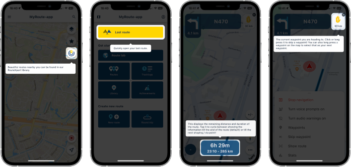
Can the walkthroughs be skipped? No! It only takes a few click and we believe it adds a lot of information about the app, such that everybody should see it at least once

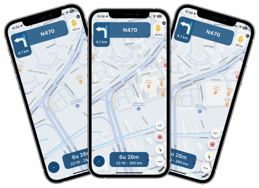
Improved tilt / zoom (dynamic camera)
In almost every update we tried to accomplish this. However..... we were stupid and missed a very stupid little detail. This explained all the user reports where they mentioned that the map would not be tilted at all So now we can finally say that the dynamic camera correctly tilts in all scenario’s. This means that you will always have a tilted view! You don’t want that? Keep on reading!
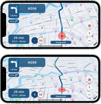
Fixed camera & zoom buttons
You knew that tapping the compass would cycle between the dynamic camera (automatic tilt & zoom) and the fixed camera (top-down view). In the fixed mode, north would always be facing up. This has been changed so that your heading faces up (like the dynamic camera).
In this camera mode the camera will always show a top-down (no tilt) view and you may choose your own zoom level using the new zoom buttons!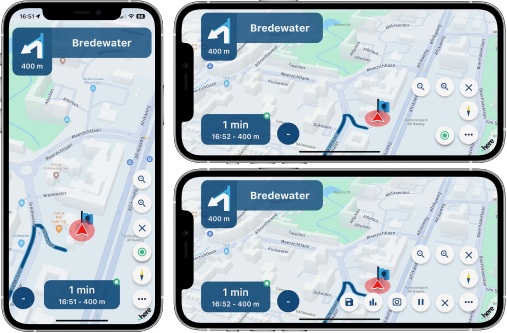
UI rework of tracking button
Adding the previously mentioned zoom buttons was a pain in the ass regarding the layout. Therefore we reworked some buttons to make better use of available space Tapping the tracklog button now pops out the different options. This allows a more scalable solution for adding buttons to the map. The same type of button has been used for the zoom buttons.
Building layout
Some people prefer 3D buildings on the map (like the app was until today) but others hated it. You can now choose this for yourself!
- “Off” doesn’t show any buildings
- “2D” only shows the footprint of buildings (this is now the default setting)
- “3D” shows them like you were used to
We thought it would be best to make 2D the default as this is what most people seem to prefer.
Where can you change this setting? Map layout might be a good place to look.
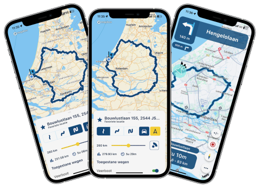
Long routes issue
The app wasn’t able to calculate the fastest route to a destination far away (> 600km). This has now been fixed!
A nice extra is that the calculated fastest route now matches the selected suggested route when starting navigation.Traffic preference
In the functional navigation settings there was a setting to toggle “Traffic information”. This has been renamed to “Traffic aware route calculation”. When enabled the map will show traffic jams and takes them into account when calculating the route
Using routes from the website? The behavior in the app and routeplanner are aligned! This ensures that you always drive the route exactly as you planned it.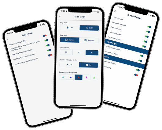
Improved waypoint list
The waypoint list is a great tool to show the passed and remainder of your route.
As of this update it actually opens at the upcoming waypoint, the menu cannot be closed accidentally anymore and we’ve added a visual distinction between the passed, current and upcoming waypoints.Resume navigation issue
When resuming a previous navigation session sometimes the incorrect waypoint was used. This issue has been fixed!
Bad internet & login page
If you had a bad internet connection the login page would sometimes appear. We’ve made improvements to prevent this from happening. If you still encounter it, please let us know!Creating scenic routes & round tours
Fixed two major frustrations regarding the route creation menu:- It cannot be closed anymore by swiping it down
- When changing the travel mode the calculated route now also updates appropriately
Offline mode indicator
Are you driving in offline mode? We’ve added a nice little indicator to show this.Track navigation validation
When loading a track in navigation, you sometimes see warnings about errors in the route. This popup is purely informational but can be frustrating if you drive a lot of tracks. If you really don’t care about the warning, it can be turned off from the functional navigation settingsUsing TomTom / OSM routes
If you open a route created in the TomTom / OSM map for navigation, we now display a warning that the calculated route might differ from the planned route. This makes sense because the app uses HERE as foundation of the navigation. You may choose to accept any (possible) differences for what it is or load it as track. Using track navigation ensures you drive exactly what you planned but you loose all waypoint functionality.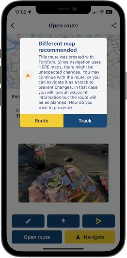
What's next?
The release is approaching fast! With this update we are confident that the app is ready for a great release
In the remaining two weeks the most important issues we will work on and make sure that they are fixed are:- Offline maps download stability / lack of progress
- Voice prompt stability & configuration options
- Battery usage
Obviously we still got some other minor features we want to implement but the above will be the focus. Besides that, we'll keep on processing all your feedback
Looking forward to your experiences with this update!
Best,
Corjan@Corjan-Meijerink Next up... developing a new app symbol?
-
@Corjan-Meijerink That is what I thought. Thank you. Looking good so far.
-
@Albert-van-den-Elsen mijn TomTom er ook afgehaald ondertussen
Dan wordt dit een optie met een ruggedized tablet
https://www.facebook.com/groups/drivemodeusers -
Hey everyone!
Today is the day for another big update! We've fixed the most crucial issue in the app and added / tweaked a lot of functionalities! We're pretty sure that you will be very pleased with this update
It will be available somewhere between today and tomorrow
Obviously we gave this update a good test about which you can read here: https://forum.myrouteapp.com/topic/4379/alpha-test-result
Position delay
Finally the day is here that we can announce that the position delay in the app has been fixed! Not a lot of images to share or to write about but this is the most important change of the update! I’d simply recommend that you all go out and enjoy the weather to experience it for yourself.App walkthrough
As we are approaching the release, we need to make sure that users understand the app! Therefore we’ve added two walkthroughs in the app- The first explains the basic functionalities of the app previously known as the “Mobile” app. This will allows users to understand where they can find which features.
- The second walkthrough explains the layout of the navigation module and the important nifty little features you can find there. For example tapping the ETA field.
Can the walkthroughs be skipped? No! It only takes a few click and we believe it adds a lot of information about the app, such that everybody should see it at least once
Improved tilt / zoom (dynamic camera)
In almost every update we tried to accomplish this. However..... we were stupid and missed a very stupid little detail. This explained all the user reports where they mentioned that the map would not be tilted at all So now we can finally say that the dynamic camera correctly tilts in all scenario’s. This means that you will always have a tilted view! You don’t want that? Keep on reading!Fixed camera & zoom buttons
You knew that tapping the compass would cycle between the dynamic camera (automatic tilt & zoom) and the fixed camera (top-down view). In the fixed mode, north would always be facing up. This has been changed so that your heading faces up (like the dynamic camera).
In this camera mode the camera will always show a top-down (no tilt) view and you may choose your own zoom level using the new zoom buttons!UI rework of tracking button
Adding the previously mentioned zoom buttons was a pain in the ass regarding the layout. Therefore we reworked some buttons to make better use of available space Tapping the tracklog button now pops out the different options. This allows a more scalable solution for adding buttons to the map. The same type of button has been used for the zoom buttons.Building layout
Some people prefer 3D buildings on the map (like the app was until today) but others hated it. You can now choose this for yourself!- “Off” doesn’t show any buildings
- “2D” only shows the footprint of buildings (this is now the default setting)
- “3D” shows them like you were used to
We thought it would be best to make 2D the default as this is what most people seem to prefer.
Where can you change this setting? Map layout might be a good place to look.
Long routes issue
The app wasn’t able to calculate the fastest route to a destination far away (> 600km). This has now been fixed!
A nice extra is that the calculated fastest route now matches the selected suggested route when starting navigation.Traffic preference
In the functional navigation settings there was a setting to toggle “Traffic information”. This has been renamed to “Traffic aware route calculation”. When enabled the map will show traffic jams and takes them into account when calculating the route
Using routes from the website? The behavior in the app and routeplanner are aligned! This ensures that you always drive the route exactly as you planned it.Improved waypoint list
The waypoint list is a great tool to show the passed and remainder of your route.
As of this update it actually opens at the upcoming waypoint, the menu cannot be closed accidentally anymore and we’ve added a visual distinction between the passed, current and upcoming waypoints.Resume navigation issue
When resuming a previous navigation session sometimes the incorrect waypoint was used. This issue has been fixed!Bad internet & login page
If you had a bad internet connection the login page would sometimes appear. We’ve made improvements to prevent this from happening. If you still encounter it, please let us know!Creating scenic routes & round tours
Fixed two major frustrations regarding the route creation menu:- It cannot be closed anymore by swiping it down
- When changing the travel mode the calculated route now also updates appropriately
Offline mode indicator
Are you driving in offline mode? We’ve added a nice little indicator to show this.Track navigation validation
When loading a track in navigation, you sometimes see warnings about errors in the route. This popup is purely informational but can be frustrating if you drive a lot of tracks. If you really don’t care about the warning, it can be turned off from the functional navigation settingsUsing TomTom / OSM routes
If you open a route created in the TomTom / OSM map for navigation, we now display a warning that the calculated route might differ from the planned route. This makes sense because the app uses HERE as foundation of the navigation. You may choose to accept any (possible) differences for what it is or load it as track. Using track navigation ensures you drive exactly what you planned but you loose all waypoint functionality.What's next?
The release is approaching fast! With this update we are confident that the app is ready for a great release
In the remaining two weeks the most important issues we will work on and make sure that they are fixed are:- Offline maps download stability / lack of progress
- Voice prompt stability & configuration options
- Battery usage
Obviously we still got some other minor features we want to implement but the above will be the focus. Besides that, we'll keep on processing all your feedback
Looking forward to your experiences with this update!
Best,
Corjan@Corjan-Meijerink Goed bezig! Is nu al een verbetering tov de oude app, wordt alleen nog maar beter!
-
Dan wordt dit een optie met een ruggedized tablet
https://www.facebook.com/groups/drivemodeusers@Johan-Ri ja of een CarPlay/Android Auto apparaat voor op de motor. Althans dat is wat ik heb.
-
Corjan
Wat ik nog mis naast de flitscamera’s is de gemiddelde snelheid die je rijdt bij traject controles. In mijn omgeving zijn zijn er die veel. TomTom heeft dat goed voor elkaar en is de enige reden dat ik dat ook nog gebruik. Hopenlijk kun je dit na de relase nog inbouwen.
Hans
-
@Hans-van-de-Weem dat zou inderdaad heel nuttig zijn! Flitsmeister heeft dat ook. Verder is het team natuurlijk goed bezig !
-
Unbelievable! Great work, as ever.
greetings
ronni
Hello! It looks like you're interested in this conversation, but you don't have an account yet.
Getting fed up of having to scroll through the same posts each visit? When you register for an account, you'll always come back to exactly where you were before, and choose to be notified of new replies (either via email, or push notification). You'll also be able to save bookmarks and upvote posts to show your appreciation to other community members.
With your input, this post could be even better 💗
Register Login-
08155
-
1572
-
07151
-
08176
-
0425
-
0225
-
7221.4k
-
0341.6k