Export 1.2 gpx
-
I understand the question about the formation points, but the choice to change the gpx 1.1 (Beta) is that it can now be used for all Zumo devices with the NTU card (XT, 590, 346, BMW Navigator 6), and there is no need to create a separate gpx file for each Zumo.
You can only put 29 waypoints in a route today without the Zumo splitting them.
What do you use the formation points for if I may ask Dave?@Hans-van-de-Ven-MRA-Master I use via/flag points as definite stops that I must get too for facilities and RV. The formation/shaping allows me to see the points that I had planned to ‘go through’ but I can skip one or more of these on the device if I need/want with the device then recalculating to the next formation point - I can also see the points on the map overview if I am looking on how many I need/want to skip. Having just a track showing in the background means I have to manually route back to the track further along with the device trying to route me back to the original track and/or next via (not sure as I have not tried live yet). I do have the track on in the background as a safeguard against strange routing calculation that devices can do ‘on the day’ but, for me, a whole level of functionality has been removed by not having the formation/shaping points included in the ‘trip’. I am aware that there is a limit to via/waypoints on Zumo but you can have a large number of formation/shaping points between these via points. I have also had a TomTom previously where track was king but the Zumo works differently and it took me a while to get used to this different approach but I now like it. I hope this all makes sense.
I understand that you want a common export for Zumo models but this change from the beta is forcing me to use my device in a backward step way. I am somewhat disappointed with what was released from what I had come to expect from the beta. MRA was my Basecamp(yuk) alternative and it worked well, please find a way to re-implement what we had in the beta.
-
@Dave-J-0
Hi Dave,If you use / import route from the gpx 1.0 and gpx 1.1 into your Zumo, all formation points are seen as waypoints, therefore you will get the message that the route is being split.
The advice was always to use the Track. With the release of the XT, the Beta version of the gpx 1.1 was used to test whether
the via points could be worked. So the waypoints only worked on the XT, but not on the older Zumos because all formation points were seen as waypoints, and you don't want that either. How Garmin handles this is Garmin's secret and they won't reveal it.I will submit the request for Beta version for the XT to MRA.
@Hans-van-de-Ven-MRA-Master said in Export 1.2 gpx:
I will submit the request for Beta version for the XT to MRA.
Thank you Hans.

-
Today I have tested the new GPX 1.2 format with my ZumoXT. If you use this format, the newcalculation must swiched off. Otherwise the route will be destroyed.
I have created a route only with shaping point ( points without alarm). After the import into my ZumoXT via Garmin Drive app the route was exactly the same as planned in MRA. Everything looks good. Then I forces the ZumoXT to a new calculation. This ends up with a route from start to destination. In my case from home start to home. The route was only 100 m long.
When I use a route in the older beta formart then a new calculation follows the shaping points.
Conclusion: MRA shold use the shapingpoints in the GPX 1.2 format.Kindly regards
ReinhardMontana 700i and Mac
-
Today I have tested the new GPX 1.2 format with my ZumoXT. If you use this format, the newcalculation must swiched off. Otherwise the route will be destroyed.
I have created a route only with shaping point ( points without alarm). After the import into my ZumoXT via Garmin Drive app the route was exactly the same as planned in MRA. Everything looks good. Then I forces the ZumoXT to a new calculation. This ends up with a route from start to destination. In my case from home start to home. The route was only 100 m long.
When I use a route in the older beta formart then a new calculation follows the shaping points.
Conclusion: MRA shold use the shapingpoints in the GPX 1.2 format.Thanks for the reply. If you don't use via-points (point with alarm) then it is better to use the track.
-
Hi all,
From the developers, if you don't use via-points, you can use the gpx 1.1 file.
I did a small test with a route, starting from home to the first point of the route, with recalculation ON.
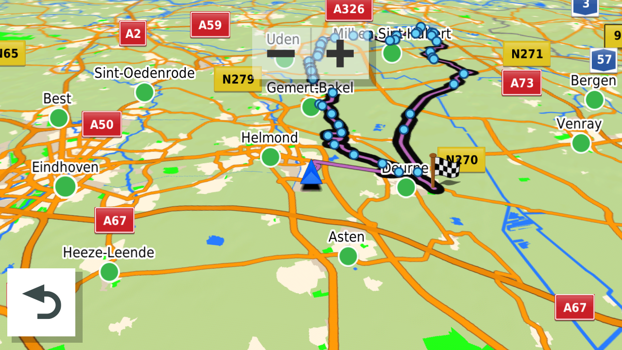
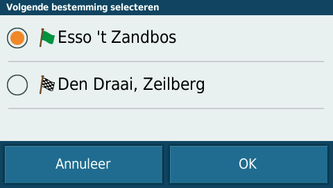
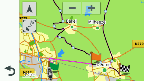
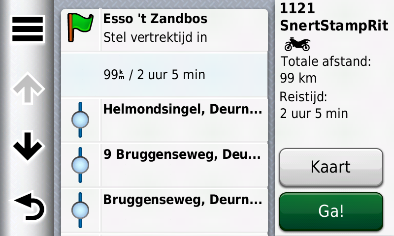
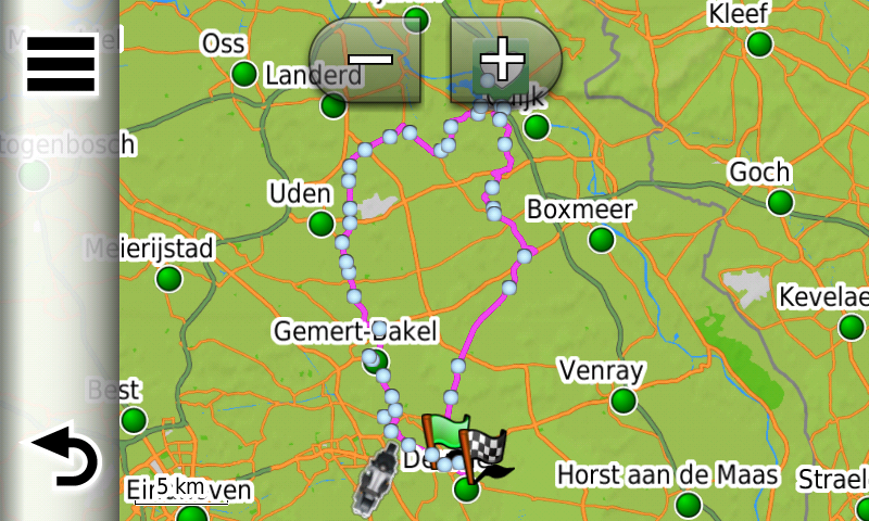
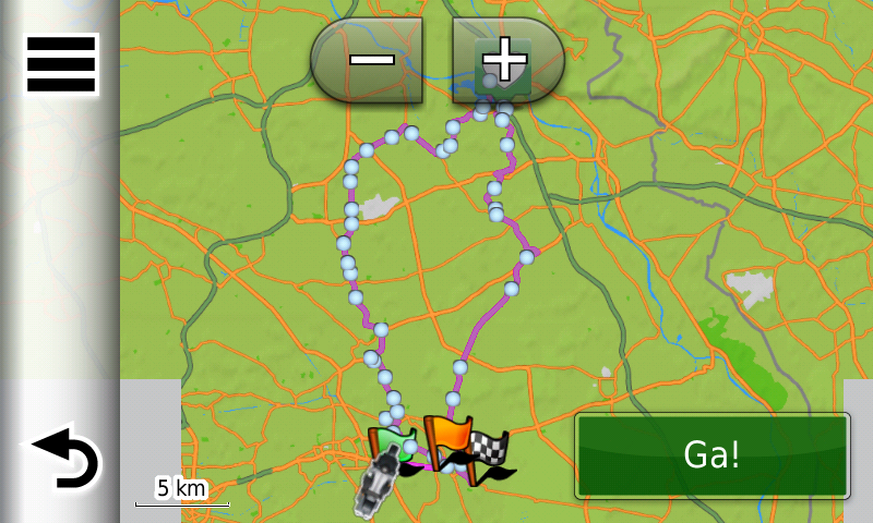
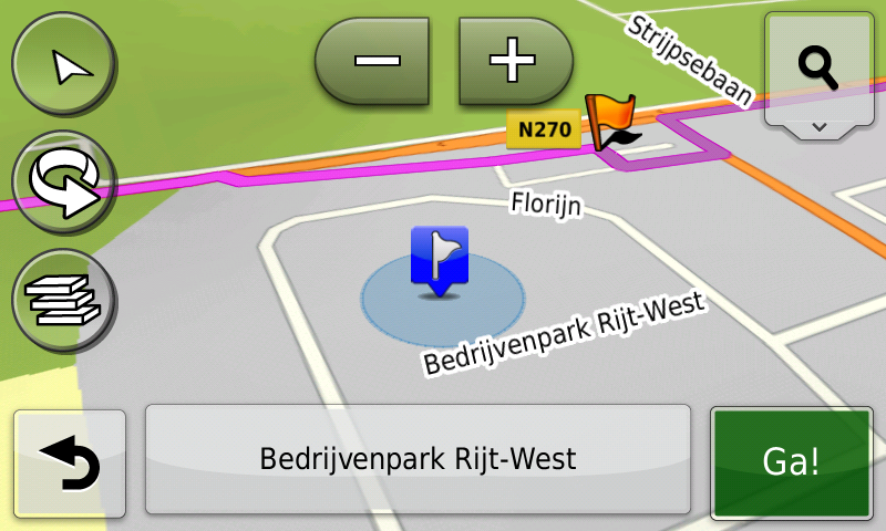
The route is NOT distroyed, see pictures below: (tack is black in the background)Route exported as Garmin Zumo gpx 1.1, all the shaping points are there.
The route in my XT.
The route, recalculated from my home to the first point on the route:
Only the via-points are not in this file,
Special for the users who want via-points (places where you will sop or drive by) is the Garmin Zumo gpx 1.2 file
The gpx 1.2 is basicly an Unflagged routeHope this wil help?
-
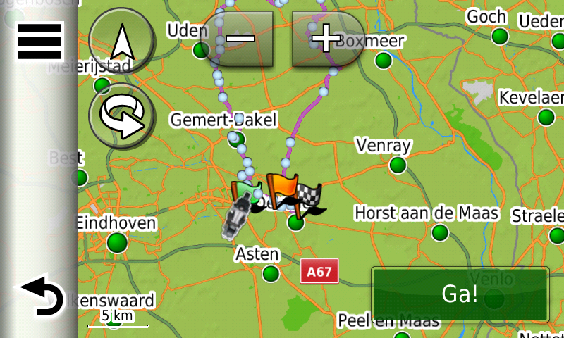
Hi all, test in the Zumo 346 gpx 1.1
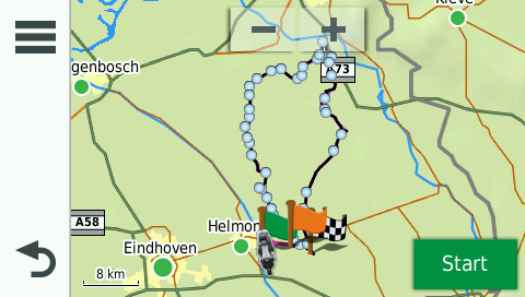
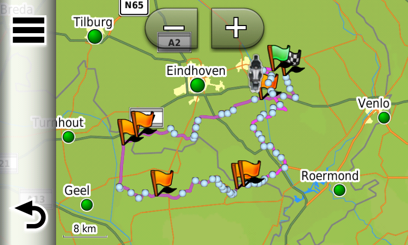
The route with shaping points:
Route as picture:
Option to start the route, DO NOT CHOOSE THE END POINT!, because you wil be directed to the end point.
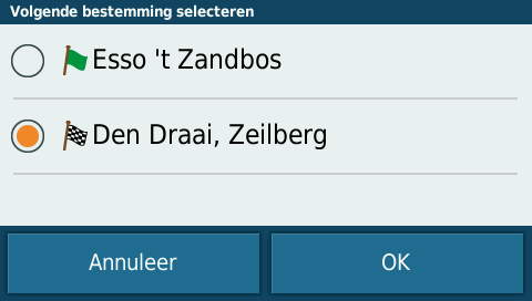
Choose the starting point of the route!
Directed to the startpoint and the route is not destroyed.
-
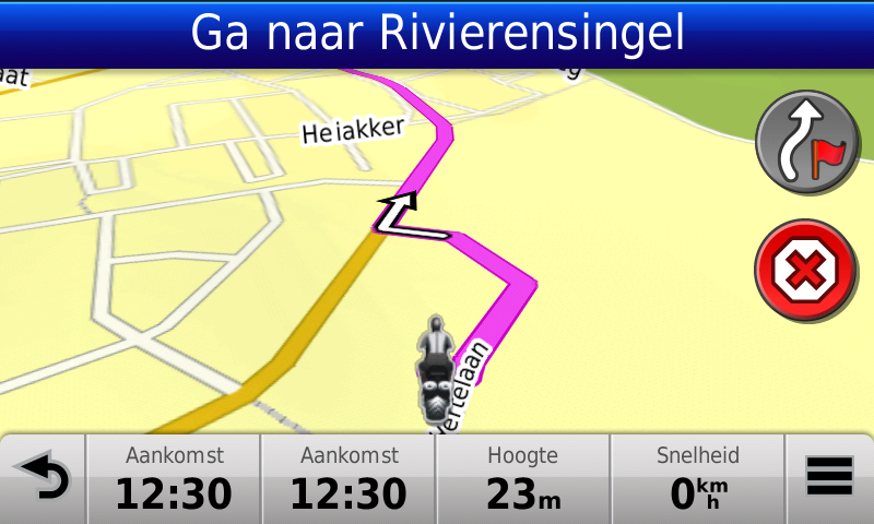
Hi all, test in de BMW Navigator 6 with the gpx 1.1 file
Route with shaping points:
Route as picture
Start option, choose the start location
route = OK
Directed to the start location and route is not destroyed.
-
Hi all, test in the Zumo 660 with the gpx 1.0 and 1.1 file (same results)
The 660 creates .bmp files, unfortunally this fileformat is not supported on the forum.
The 660 shows all shaping points as via-points (flags)
First drive to the starting point before you start the route, otherwise the route wil be destroyed. -
@Dave-J-0
Hi Dave,If you use / import route from the gpx 1.0 and gpx 1.1 into your Zumo, all formation points are seen as waypoints, therefore you will get the message that the route is being split.
The advice was always to use the Track. With the release of the XT, the Beta version of the gpx 1.1 was used to test whether
the via points could be worked. So the waypoints only worked on the XT, but not on the older Zumos because all formation points were seen as waypoints, and you don't want that either. How Garmin handles this is Garmin's secret and they won't reveal it.I will submit the request for Beta version for the XT to MRA.
@Hans-van-de-Ven-MRA-Master
I created a new route for testing and testet it last Sunday.
The good news: the route works. But shaping points are not displayed but they are existing. The defined route with all detours shows it.
Unfortunately there are a few points to criticise:
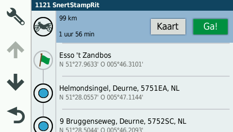
The import in the navigator, - i.e. the time the navigator needs to import the route - is veeeeery slow. A route with 8 viapoints and 29 shaping points needed more than 6 minutes. With Beta 1.2, such a route needed about 30 seconds. ????
Shaping points are not displayed after the import. Neither in the map nor in the list. If I have to make a change in the navigator on the way (e.g. when a street is blocked), how can I change a shaping point into a via point? I can't. I can change a via point into a shaping point in the navigator. The shaping point then will be displayed. The recalculation now takes a few seconds.
The export (Save as) with GPX 1.2 works. In other programmes like Tyre or ITN converter only via points are imported, in kuviger.de via and shaping points. After copying a GPX-file edited by kuviger.de into the Navigator, only Viapoints are displayed again.
Despite all the joy that GPX 1.2 finally works on the Navigator, the lack of shaping points is a clear step backwards. I can only agree: please bring back the shaping points.
Grüße aus dem Schwabenland
Stefan -
@Hans-van-de-Ven-MRA-Master
I created a new route for testing and testet it last Sunday.
The good news: the route works. But shaping points are not displayed but they are existing. The defined route with all detours shows it.
Unfortunately there are a few points to criticise:
The import in the navigator, - i.e. the time the navigator needs to import the route - is veeeeery slow. A route with 8 viapoints and 29 shaping points needed more than 6 minutes. With Beta 1.2, such a route needed about 30 seconds. ????
Shaping points are not displayed after the import. Neither in the map nor in the list. If I have to make a change in the navigator on the way (e.g. when a street is blocked), how can I change a shaping point into a via point? I can't. I can change a via point into a shaping point in the navigator. The shaping point then will be displayed. The recalculation now takes a few seconds.
The export (Save as) with GPX 1.2 works. In other programmes like Tyre or ITN converter only via points are imported, in kuviger.de via and shaping points. After copying a GPX-file edited by kuviger.de into the Navigator, only Viapoints are displayed again.
Despite all the joy that GPX 1.2 finally works on the Navigator, the lack of shaping points is a clear step backwards. I can only agree: please bring back the shaping points.
Hallo Stefan,
Lesen Sie sorgfältig, das gpx 1.1 hat sowohl Formation als auch Wegpunkte. Funktioniert nur bei Zumos mit NTU-Karte, also auch beim Navigator 6. An der Langsamkeit des Imports können wir nichts ändern, es hängt vom Gerät ab, wie schnell es die Daten verarbeiten kann.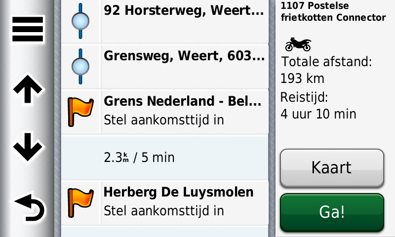
Garmin Zumo XT3/XT2/XT/BMW Connected Ride Navigator/Tourstart/ MyRouteapp (The App)/...
Een dag niet gelachen is een dag niet geleefd / Een route is net zo goed als deze uitgezet is. -
Hallo Stefan,
Lesen Sie sorgfältig, das gpx 1.1 hat sowohl Formation als auch Wegpunkte. Funktioniert nur bei Zumos mit NTU-Karte, also auch beim Navigator 6. An der Langsamkeit des Imports können wir nichts ändern, es hängt vom Gerät ab, wie schnell es die Daten verarbeiten kann.@Hans-van-de-Ven-MRA-Master
Hello Hans,GPX 1.1 can transmit shaping points and via points, Obviously. However, when importing GPX 1.1, only shaping points are transferred. I have to change the shaping points into via points manually. Why should I do this when GPX 1.2 transfers BOTH types. The shaping points are there, you just should make them visible and editable again.
Since yesterday I have a Zumo XT. The import is indeed much faster than with Navigator 6.
Grüße aus dem Schwabenland
Stefan -
@Hans-van-de-Ven-MRA-Master
Hello Hans,GPX 1.1 can transmit shaping points and via points, Obviously. However, when importing GPX 1.1, only shaping points are transferred. I have to change the shaping points into via points manually. Why should I do this when GPX 1.2 transfers BOTH types. The shaping points are there, you just should make them visible and editable again.
Since yesterday I have a Zumo XT. The import is indeed much faster than with Navigator 6.
When you are in the planner, change a shapingpiont into a viapunt. Then export to the device
-
@Hans-van-de-Ven-MRA-Master
I have to agree with all the other users who are saying that we want to actually see the shaping points (Blue Dots) on the XT map.
As we could on the XT with the previous Beta version.
My personal preference is to never use Via Points.
When I create a new route I don’t know at what point I might need a coffee or at what point in time I am going to get hungry.
I like to make those decisions whilst actually riding the route.
What do i do if I want to skip part of the of the route for some reason?
If we can’t see the shaping points how can we skip them?@Steve-Lynch I use viewpoints for coffee stops and lunch stops as this is another way of making sure that everyone in a group gets to the same place and a chance for stragglers to catch up. Having a coffee stop mid morning then lunch etc. means that if someone falls behind, they are never that far behind.
Like you, skipping a shaping point causes a problem. Perhaps there are roadworks or a diversion. If you skip and go to the next point, the GPS will skip the next viapoint (ignoring the viapoint).
To get round this I publish two files for each route with the 2nd one having all the shaping points converted to a viapoint and, to keep them tidy, I rename them with the prefix Z which means that you can find them if needed but they are not mixed in with your normal day to day files.
Another option would be to pass the diversion following the signs then start the route again with the next point being the next viapoint. This would however skip any shaping points that you had planned.
I am of course working with groups of Riders. Had I been solo, I would do as you do and not plan coffee stops etc.
-
@Steve-Lynch I use viewpoints for coffee stops and lunch stops as this is another way of making sure that everyone in a group gets to the same place and a chance for stragglers to catch up. Having a coffee stop mid morning then lunch etc. means that if someone falls behind, they are never that far behind.
Like you, skipping a shaping point causes a problem. Perhaps there are roadworks or a diversion. If you skip and go to the next point, the GPS will skip the next viapoint (ignoring the viapoint).
To get round this I publish two files for each route with the 2nd one having all the shaping points converted to a viapoint and, to keep them tidy, I rename them with the prefix Z which means that you can find them if needed but they are not mixed in with your normal day to day files.
Another option would be to pass the diversion following the signs then start the route again with the next point being the next viapoint. This would however skip any shaping points that you had planned.
I am of course working with groups of Riders. Had I been solo, I would do as you do and not plan coffee stops etc.
90% of the time I prefer to travel alone. (Billy No Mates or maybe Victor Meldrew
 ).
).
I live in London but my Biker Mates are mostly down the South Coast, from Brighton to Eastbourne, generally I meet up with them only during the summer month’s, except one in particular that I went to School with and often ride to him for a stay over consisting of beer, curry and the obligatory hangover.
Generally this crowd stay around the south coast area and generally one them will lead as they have the better local knowledge of the South Coast. -
The same effect, when exporting direct to BMW Navigator. It's not uasable.
Friedhelm -
The same effect, when exporting direct to BMW Navigator. It's not uasable.
Friedhelm@Bepperling
Which Navigator do you have the 5 or the 6?
With the navigator 5, it uses the NT map, it doesn't work, just like the older zumo's. -
@Hans-van-de-Ven-MRA-Master
Hello Hans,GPX 1.1 can transmit shaping points and via points, Obviously. However, when importing GPX 1.1, only shaping points are transferred. I have to change the shaping points into via points manually. Why should I do this when GPX 1.2 transfers BOTH types. The shaping points are there, you just should make them visible and editable again.
Since yesterday I have a Zumo XT. The import is indeed much faster than with Navigator 6.
Good choice on updating to the Garmin XT.
I have had mine for a while now and in my experience the plethora of recent updates by the MRA Devs have made the XT even better.
Happy days.You don’t stop riding when you get old, you get old when you stop riding.
-
Good choice on updating to the Garmin XT.
I have had mine for a while now and in my experience the plethora of recent updates by the MRA Devs have made the XT even better.
Happy days.@Steve-Lynch said in Export 1.2 gpx:
My Navigator 6 had ghosting. My BMW dealer offers as an exchange only the XT, because the ghosting occurs again sooner or later with a new NAvigator. Because the XT is a new device, I have again a warranty of 2 years.

-
Use via-points in your route, otherwise use gpx1.1
@Hans-van-de-Ven-MRA-Master I just wanted to agree with other replies in this thread. In the past I would have the formation points (blue dots) and waypoints (flags). I would often put multiple waypoints (flags) that I may stop at and I wanted announced, knowing I would stop at some and skip some depending on how the day went. In the past I would have the one skip button on my Zumo xt and I would skip waypoints (flags) but because of all the formation points (blue dots) the overall navigation would stay intact.
Now when I first load the trip into my Zumo the track looks good and the navigation is accurate even without the blue dot formation points. However the first time I skip something on my route the Zumo recalculates everything without any regard to the formation points that would have been there in the past and I get a direct route to my next flag point rather than the planned route between the flags I had.
I bought the garmin xT specifically because of how MyRoute-app and the xT worked well together, with this change to the beta 1.2 export my Zumo really no longer does the things I need it to do. If you could restore the functionality it would be greatly appreciated.
-
@Hans-van-de-Ven-MRA-Master I just wanted to agree with other replies in this thread. In the past I would have the formation points (blue dots) and waypoints (flags). I would often put multiple waypoints (flags) that I may stop at and I wanted announced, knowing I would stop at some and skip some depending on how the day went. In the past I would have the one skip button on my Zumo xt and I would skip waypoints (flags) but because of all the formation points (blue dots) the overall navigation would stay intact.
Now when I first load the trip into my Zumo the track looks good and the navigation is accurate even without the blue dot formation points. However the first time I skip something on my route the Zumo recalculates everything without any regard to the formation points that would have been there in the past and I get a direct route to my next flag point rather than the planned route between the flags I had.
I bought the garmin xT specifically because of how MyRoute-app and the xT worked well together, with this change to the beta 1.2 export my Zumo really no longer does the things I need it to do. If you could restore the functionality it would be greatly appreciated.
This was resolved.
Use GPX 1.1 (Route, Track, POI)
That will give you the Via Points and Shaping Points on the XT.You don’t stop riding when you get old, you get old when you stop riding.
Hello! It looks like you're interested in this conversation, but you don't have an account yet.
Getting fed up of having to scroll through the same posts each visit? When you register for an account, you'll always come back to exactly where you were before, and choose to be notified of new replies (either via email, or push notification). You'll also be able to save bookmarks and upvote posts to show your appreciation to other community members.
With your input, this post could be even better 💗
Register Login-
7733.3k
-
09137
-
120549
-
316929
-
04117
-
05173
-
04113
-
-15211