Skip to content
  • Categories
  • Recent
  • Popular
  • Support
  • MyRoute-app
Collapse
Brand Logo

MRA Community Forum

  1. Home
  2. General Discussion
  3. Best way to set my Garmin Zumo XT to play well with the MRA?

Best way to set my Garmin Zumo XT to play well with the MRA?

Scheduled Pinned Locked Moved General Discussion
14 Posts 7 Posters 320 Views 6 Watching
  • Oldest to Newest
  • Newest to Oldest
  • Most Votes
Reply
  • Reply as topic
Log in to reply
This topic has been deleted. Only users with topic management privileges can see it.
  • Mike wiruthundefined Offline
    Mike wiruthundefined Offline
    Mike wiruth
    wrote last edited by
    #1

    Hello all, I'm looking for advice for setting up my Garmin Zumo XT. I plan my routes with the desktop app and then I transfer the gpx file to my garmin. For those that do the same, can you advise me on the settings for my garmin so it will not change my route that was sent from the MRA app. The last big trip I took my garmin would try to change the route and not match what was on my phone with the MRA. Has anyone else had this problem. I like to run them both as it seems easier to search things on my zumo.
    Thanks for any help you can give me.
    Mike

    Mike W
    2013 Honda Goldwing
    Bushtec Trailer
    Garmin Zumo XT
    Nebraska
    youTube channel https://www.youtube.com/@mrjawmaster5854

    Brian McGundefined 1 Reply Last reply
    0
    • Mzokkundefined Offline
      Mzokkundefined Offline
      Mzokk
      wrote last edited by
      #2

      Try this Link. It has most of the information you're after.

      https://forum.myrouteapp.com/topic/9299/how-to-keep-routes-consistent-when-exporting-to-garmin-zumo-xt/3?_=1779717812842

      I used my Garmin Zumo XT on my Honda Africa Twin for navigation until spring of 2025 when MyRoute app became reliable enough for me to use it for navigation via the Honda's Android Auto Screen. I use old Zumo 340 and 390 for navigation on my 24 year old R1150GS and I much prefer these for navigation as with Basecamp they are WYSIWYG as long as the settings on the unit and basecamp match. I'm a 22 year user of Garmin motorcycle navigators but between the Zumo 340 and 390 that I have and the XT they changed the routing algorithm so that "Faster Time" between waypoints now means faster roads.....so the unit will always try to take you via motorways and dual carriageways between waypoints if possible.

      I only use my Zumo XT for tracks and proximity alerted POI's which MRA does not do yet.

      1 Reply Last reply
      0
      • Mzokkundefined Offline
        Mzokkundefined Offline
        Mzokk
        wrote last edited by
        #3

        Just another point. Garmin tracks on older zumo's displayed as a thin line on top of the magenta navigation line. On the XT the track is displayed BELOW the magenta line and is the same width so you can only see it if the route line deviates from the track. To fix this you can do as I've done and make a custom theme that makes the track line thicker so that you can see it below the route line. And for the sake of your sanity do not connect your XT to "Garmin Explore" and if you have follow the instructions on the Garmin Zumo Forums to disconnect it!

        1 Reply Last reply
        0
        • Hubert Thoringundefined Offline
          Hubert Thoringundefined Offline
          Hubert Thoring
          Valued contributor
          wrote last edited by
          #4

          The Garmin on "fastest connection" between the WP and SP.

          Export the MRA Route as format 1.1 GPX and load it in the Garmin ...

          When planning as much as possible SP put so that the path is clearly described,...

          Then that should fit, the Garmin is limited with fixed WP as far as I know.

          VG 👋

          VG Hubert
          Beta Test "Next App" dazu die Hardware .
          iPad 9. Gen iOS 26.5 / iPhone 16e iOS 26.5/ Navi iPhone Xr iOS 18.7.9 / PC mit MS Win11 /❗️MyRoute-App im Cradel und Remotek-One❗️ Info zu MRA & Remotek One

          1 Reply Last reply
          0
          • AWDC LAOundefined Offline
            AWDC LAOundefined Offline
            AWDC LAO
            wrote last edited by
            #5

            There are two versions of GPS v1.1; v1.0 is older but more reliable.
            MARA has become so good that for on-road use, your smartphone is all you need.
            I use the XT2 or XT3 for off-road use and for following a track.

            R1300GS Adv BlackPanther BMW, Apple MacBook Pro M4, Carpe Iter V4c, ervaring met TTR550, ZumoXT2 & iPhone 12 pro max.

            1 Reply Last reply
            1
            • white.mouseundefined Offline
              white.mouseundefined Offline
              white.mouse
              Valued contributor
              wrote last edited by
              #6

              The best way, I found out is to make the route in MRA and export it as GPX 1.1 (route, track, poi).
              Then use the "good" old Basecamp and import this file. you will see now in Basecamp the track and a route existing of straight lines.
              Now open the route and let Basecamp recalculate. You'll find out that the route now follows more or less the track which is also visible in Basecamp .
              Manualy put in extra waypoint to make the route follow the track exact.
              There is no standard setting to avoid this problem.
              After that you can connect the GPS to your computer and in Basecamp, with a left click on the map existing the track and route you get an option to send it direct to the GPS.
              This is the most solit way.

              met een R1250RT met TFT en BMW Connected Ride App (die dus nog steeds niet voldoet!) ;
              de Garmin Zumo XT en M.R.A. in combinatie met de Carpuride W702 (voor Android op de Motor!)

              1 Reply Last reply
              0
              • Mzokkundefined Offline
                Mzokkundefined Offline
                Mzokk
                wrote last edited by
                #7

                Nope you don't need to put the additional unnecessary step of exporting to Basecamp. Just create the route with plenty of shaping (teardrop) points between Via(hand) points and download the file as gpx1.1 and send it via your phone using Garmin Drive. You can also use GPX 1.2 but if you do switch off auto recalculate......or the Garmin will take you straight to the end.

                1 Reply Last reply
                0
                • Guzzistundefined Offline
                  Guzzistundefined Offline
                  Guzzist
                  Valued contributor
                  wrote last edited by
                  #8

                  That is the issue with every Route planner, sending the route to another navigation app/device. Each has it's own algorithm. So it's nearly impossible, to setup on each end the same settings. The only way is, to enter "enough" route points during planning, to force navigation apps/devices to use exactly that roads you have planned.
                  But as @hubert-thoring said: Garmin devices has limited capacity for work with via points (route points). But you can work in MRA with shaping points, which are also route points (with some differences in the effect).

                  Nothing is impossible ;-)
                  In past: GARMIN Zumo 210->GARMIN Zumo 395->GARMIN XT=> now: DMD T865-X + MyRoute-App, LocusMaps, OsmAnd.
                  In past: GARMIN MapSource ->GARMIN BaseCamp->Tyre->Kurviger->Calimoto=> now: MRA-Routplanner.

                  1 Reply Last reply
                  1
                  • Mzokkundefined Offline
                    Mzokkundefined Offline
                    Mzokk
                    wrote last edited by
                    #9

                    The Zumo XT can handle 30 via (stop points) and 125 shaping points between each via point. So plenty for most purposes. Tracks cancelled have 10,000 points.

                    1 Reply Last reply
                    1
                    • AWDC LAOundefined Offline
                      AWDC LAOundefined Offline
                      AWDC LAO
                      wrote last edited by AWDC LAO
                      #10

                      Garmin has also an APP : TREAD for the XT2/3, or do you have XT1 ?

                      R1300GS Adv BlackPanther BMW, Apple MacBook Pro M4, Carpe Iter V4c, ervaring met TTR550, ZumoXT2 & iPhone 12 pro max.

                      white.mouseundefined Guzzistundefined 2 Replies Last reply
                      0
                      • AWDC LAOundefined AWDC LAO

                        Garmin has also an APP : TREAD for the XT2/3, or do you have XT1 ?

                        white.mouseundefined Offline
                        white.mouseundefined Offline
                        white.mouse
                        Valued contributor
                        wrote last edited by
                        #11

                        @AWDC-LAO said:

                        Garmin has also an APP : TREAD for the XT2/3, or do you have XT1 ?

                        I haven't heard much good about it. Especially when it comes to importing routes

                        met een R1250RT met TFT en BMW Connected Ride App (die dus nog steeds niet voldoet!) ;
                        de Garmin Zumo XT en M.R.A. in combinatie met de Carpuride W702 (voor Android op de Motor!)

                        1 Reply Last reply
                        0
                        • Mike wiruthundefined Mike wiruth

                          Hello all, I'm looking for advice for setting up my Garmin Zumo XT. I plan my routes with the desktop app and then I transfer the gpx file to my garmin. For those that do the same, can you advise me on the settings for my garmin so it will not change my route that was sent from the MRA app. The last big trip I took my garmin would try to change the route and not match what was on my phone with the MRA. Has anyone else had this problem. I like to run them both as it seems easier to search things on my zumo.
                          Thanks for any help you can give me.
                          Mike

                          Brian McGundefined Offline
                          Brian McGundefined Offline
                          Brian McG
                          wrote last edited by Brian McG
                          #12

                          @Mike-wiruth as @guzzist suggests use lots of points to constrain the route to the path that you want to take

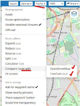
                          on the web planner you definitely want to be using "Compare" tool to ensure that OpenStreetMap & TomTom also follow the same path that Here is calculating in the MRA web planner
                          2ae9b09c-6f29-4026-9673-e81f0d7b7f67-image.jpeg
                          if TomTom or OpenStreetMap can find an alternative path you can bet that your XT will also find a different path to what you had planned

                          the XT is using a different path calculator profile to MRA even though they are both using Here maps 
                          so any calculation done by the XT is possibly going to be different unless you force (constrain) it to the same path with as many points as it takes
                          & again as @guzzist says you have to make sure the settings you have on the MRA planner match the settings on your XT as closely as you can

                          a rough guide that paths are closely matching is to make sure the mileage for the path in MRA is similar to the path on the XT
                          it is not a perfect check but if the variation is small, chances are more likely the paths are more similar

                          it is a lot of work trying to coral an XT to stick on a path you want to go & ultimately the XT will defeat you
                          you will be taken off your chosen path, I know from bitter experience

                          yes the search & poi capabilities on a Garmin are far better than MRA, especially when it comes to things like finding petrol
                          but I would rather my navigation device actually navigates exactly the path I want to go (MRA navigation does this) & sacrifice the nice feature of being able to find restaurants or hotels etc
                          after all we do have google for that sort of thing

                          & as @mzokk you dont need to pass the mra file through basecamp, that fixes nothing

                          BlackView BV7100, Android 12
                          Normally navigate "Routes as Tracks" in Offline mode with Offline Maps

                          1 Reply Last reply
                          1
                          • AWDC LAOundefined AWDC LAO

                            Garmin has also an APP : TREAD for the XT2/3, or do you have XT1 ?

                            Guzzistundefined Offline
                            Guzzistundefined Offline
                            Guzzist
                            Valued contributor
                            wrote last edited by
                            #13

                            @AWDC-LAO said:

                            Garmin has also an APP : TREAD for the XT2/3, or do you have XT1 ?

                            Folks, the issue is not the transmission method to the Garmin XT, nor the gpx file format! O.k. the file format has other issues in the Garmin device, but this is not the point in this discussion.
                            After transmit a route via gpx file to the Navi Device, it is starting the calculation, how to come from WP1 to the next WP. Yes, you can deny recalculation - but the first interpretation/calculation is necessary.

                            By the way: in many forum discussion (also in Garmin forum) users suggests not to use the bloody TREAD app...

                            And @mike-wiruth asked only why the planned route differs after transmission into the navi.

                            Nothing is impossible ;-)
                            In past: GARMIN Zumo 210->GARMIN Zumo 395->GARMIN XT=> now: DMD T865-X + MyRoute-App, LocusMaps, OsmAnd.
                            In past: GARMIN MapSource ->GARMIN BaseCamp->Tyre->Kurviger->Calimoto=> now: MRA-Routplanner.

                            1 Reply Last reply
                            0
                            • white.mouseundefined Offline
                              white.mouseundefined Offline
                              white.mouse
                              Valued contributor
                              wrote last edited by
                              #14

                              That is simply the only reason I still use Basecamp.
                              In all the time until now the route I check there (and if neccesary modify) has never been different in my XT1

                              met een R1250RT met TFT en BMW Connected Ride App (die dus nog steeds niet voldoet!) ;
                              de Garmin Zumo XT en M.R.A. in combinatie met de Carpuride W702 (voor Android op de Motor!)

                              1 Reply Last reply
                              0

                              Hello! It looks like you're interested in this conversation, but you don't have an account yet.

                              Getting fed up of having to scroll through the same posts each visit? When you register for an account, you'll always come back to exactly where you were before, and choose to be notified of new replies (either via email, or push notification). You'll also be able to save bookmarks and upvote posts to show your appreciation to other community members.

                              With your input, this post could be even better 💗

                              Register Login
                              Reply
                              • Reply as topic
                              Log in to reply
                              • Oldest to Newest
                              • Newest to Oldest
                              • Most Votes


                              ACTIVE USERS
                              white.mouseundefined
                              white.mouse
                              Guzzistundefined
                              Guzzist
                              Brian McGundefined
                              Brian McG
                              Mzokkundefined
                              Mzokk
                              AWDC LAOundefined
                              AWDC LAO
                              Mike wiruthundefined
                              Mike wiruth
                              Hubert Thoringundefined
                              Hubert Thoring
                              POPULAR TOPICS
                              • V5.1.0 - 462 New altitude/heading shows incorrect Data
                                Stanisławundefined
                                Stanisław
                                0
                                22
                                496

                              • No altitude on Android Auto screen
                                Lluis Arasanzundefined
                                Lluis Arasanz
                                0
                                7
                                82

                              • Adding a Via Point to or Edit a Round Trip
                                Con Hennekensundefined
                                Con Hennekens
                                0
                                6
                                15

                              • Navigation arrow still not stable
                                Peter Zehentreiterundefined
                                Peter Zehentreiter
                                1
                                13
                                342

                              • Best way to set my Garmin Zumo XT to play well with the MRA?
                                white.mouseundefined
                                white.mouse
                                0
                                14
                                320

                              • Live Map Updates
                                Con Hennekensundefined
                                Con Hennekens
                                2
                                12
                                336

                              • Altitude does not match
                                Stanisławundefined
                                Stanisław
                                0
                                9
                                86

                              • My route app
                                Hub 1undefined
                                Hub 1
                                0
                                9
                                229

                              MY GROUPS
                              • Login

                              • Login or register to search.
                              • First post
                                Last post
                              0
                              • Categories
                              • Recent
                              • Popular
                              • Support
                              • MyRoute-app