Shaping points and Via points
-
Hi,
Please help me to understand. I know the difference between shaping and via points and how they work, e.g., on a Garmin and not working differently for a TomTom.
I have been told that there is also a difference for Navigation Next.
But I did not notice any difference in NN.
What is the difference? Something to do with how waypoints will be automatically skipped?Hardware
iPhone 12 pro (iOS 26.2.1)
iPad (7.Gen.) 18.7.3
Oukitel RT3 Pro (Andr. 14)
Wireless CarPlay mit (Elebest C650)
Wired CarPlay (SEAT Arona - 2021)
MRA Workshops in Deutsch sind hier zu finden -
Hi,
Please help me to understand. I know the difference between shaping and via points and how they work, e.g., on a Garmin and not working differently for a TomTom.
I have been told that there is also a difference for Navigation Next.
But I did not notice any difference in NN.
What is the difference? Something to do with how waypoints will be automatically skipped?@Jörgen Via points will not be skipped automatically if you have set Automatically skip waypoints.
Also, notes for via points are read aloud at 2km but shaping point notes are read aloud at 750m.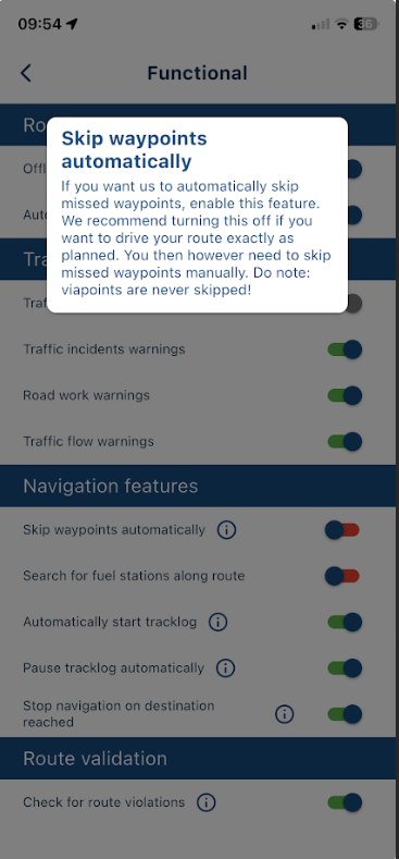
Always willing to help if I can.
Triumph Tiger 1200 XRT called Tina.
MRA Navigation Next and SilverFox BJ8 -
@Jörgen Via points will not be skipped automatically if you have set Automatically skip waypoints.
Also, notes for via points are read aloud at 2km but shaping point notes are read aloud at 750m.@Nick-Carthew said in Shaping points and Via points:
Via points will not be skipped automatically if you have set Automatically skip waypoints
Hi, thanks. I will try this, respectively I will try is again.
-
Hi,
Please help me to understand. I know the difference between shaping and via points and how they work, e.g., on a Garmin and not working differently for a TomTom.
I have been told that there is also a difference for Navigation Next.
But I did not notice any difference in NN.
What is the difference? Something to do with how waypoints will be automatically skipped?@Jörgen, Honestly, I am amazed by you asking this. This can't be new stuff to you?
I am just an enthusiastic MRA user, and hope you will be one too!
Most motorcycle problems are caused by the nut that connects the handlebar to the saddle.
Check out RideSleepRepeat.eu, a biker community for sharing stays across Europe
-
@Jörgen, Honestly, I am amazed by you asking this. This can't be new stuff to you?
@Con-Hennekens maybe it has something to do with the date
")
-
@Jörgen, Honestly, I am amazed by you asking this. This can't be new stuff to you?
@Con-Hennekens said in Shaping points and Via points:
@Jörgen, Honestly, I am amazed by you asking this. This can't be new stuff to you?
Yeah, I can imagine. I was already familiar with both features to some extent. The reason I’m asking is that the automatic skip feature didn’t work for me that way. And I just wanted to confirm that I’m understanding this correctly. I’ll have to create a test route and give it another try.
Hardware
iPhone 12 pro (iOS 26.2.1)
iPad (7.Gen.) 18.7.3
Oukitel RT3 Pro (Andr. 14)
Wireless CarPlay mit (Elebest C650)
Wired CarPlay (SEAT Arona - 2021)
MRA Workshops in Deutsch sind hier zu finden -
@Con-Hennekens said in Shaping points and Via points:
@Jörgen, Honestly, I am amazed by you asking this. This can't be new stuff to you?
Yeah, I can imagine. I was already familiar with both features to some extent. The reason I’m asking is that the automatic skip feature didn’t work for me that way. And I just wanted to confirm that I’m understanding this correctly. I’ll have to create a test route and give it another try.
@Jörgen said in Shaping points and Via points:
The reason I’m asking is that the automatic skip feature didn’t work for me that way
If you primarily use shaping points for planning rather than navigation, try the "routes as track" navigation option and toggle "Use all waypoints" off.
You get rid of all SPs, a clean look and perfect focus on your VIAs.
I like this feature when I have a route with plenty of SPs just to nail it to a specific path (typically when I convert a route-track into a route).
-
@Jörgen said in Shaping points and Via points:
The reason I’m asking is that the automatic skip feature didn’t work for me that way
If you primarily use shaping points for planning rather than navigation, try the "routes as track" navigation option and toggle "Use all waypoints" off.
You get rid of all SPs, a clean look and perfect focus on your VIAs.
I like this feature when I have a route with plenty of SPs just to nail it to a specific path (typically when I convert a route-track into a route).
@Martin-Wilcke I wish I could use MRA like that. I also would like to use shaping points just to shape the route and nothing more (no need to have ETA info for them). But the fact that via points are not skipped prevents me from doing this. Hopefully one day MRA can pick up the route when I am back on it again (meaning skip any point which is behind me).
-
@Martin-Wilcke I wish I could use MRA like that. I also would like to use shaping points just to shape the route and nothing more (no need to have ETA info for them). But the fact that via points are not skipped prevents me from doing this. Hopefully one day MRA can pick up the route when I am back on it again (meaning skip any point which is behind me).
@Herman-Veldhuizen said in Shaping points and Via points:
@Martin-Wilcke I wish I could use MRA like that. I also would like to use shaping points just to shape the route and nothing more (no need to have ETA info for them). But the fact that via points are not skipped prevents me from doing this. Hopefully one day MRA can pick up the route when I am back on it again (meaning skip any point which is behind me).
@Herman-Veldhuizen
Just use VIA only for start and finish and ride the route as track will solve your issue? -
@Herman-Veldhuizen said in Shaping points and Via points:
@Martin-Wilcke I wish I could use MRA like that. I also would like to use shaping points just to shape the route and nothing more (no need to have ETA info for them). But the fact that via points are not skipped prevents me from doing this. Hopefully one day MRA can pick up the route when I am back on it again (meaning skip any point which is behind me).
@Herman-Veldhuizen
Just use VIA only for start and finish and ride the route as track will solve your issue?@BertM No I need the ETA info to my waypoints which represent possible stops.
-
@BertM No I need the ETA info to my waypoints which represent possible stops.
@Herman-Veldhuizen said in Shaping points and Via points:
@BertM No I need the ETA info to my waypoints which represent possible stops.
ok, clear.
Never tried it, but does a 3rd VIA point not work in a track? -
@Herman-Veldhuizen said in Shaping points and Via points:
@BertM No I need the ETA info to my waypoints which represent possible stops.
ok, clear.
Never tried it, but does a 3rd VIA point not work in a track?@BertM You can get the ETA info for viapoints (hand icon) or for both viapoints and shaping points (droplet icon). How you navigate a route (route or route as track) makes currently no difference.
If you use shaping points for your possible stops they will eventually be skipped (still annoying to be sent back to the ones you missed and you will unfortunately also see the ETA for points which you added for the sole purpose to shape the route).
If you use via points for your possible stops then you can filter out the shaping points but the via points will never be skipped.
A number of people (and me) in this forum would like to see that the route can get priority over the points. They dont necessarily want to stop at each possible stop and expect the app to skip each point which is behind them on the route.
Most apps I know work that way. Apparently there is something missing in the HERE platform today to make this an option. -
@Herman-Veldhuizen
If you make the stops “possible” I get your point. -
@BertM You can get the ETA info for viapoints (hand icon) or for both viapoints and shaping points (droplet icon). How you navigate a route (route or route as track) makes currently no difference.
If you use shaping points for your possible stops they will eventually be skipped (still annoying to be sent back to the ones you missed and you will unfortunately also see the ETA for points which you added for the sole purpose to shape the route).
If you use via points for your possible stops then you can filter out the shaping points but the via points will never be skipped.
A number of people (and me) in this forum would like to see that the route can get priority over the points. They dont necessarily want to stop at each possible stop and expect the app to skip each point which is behind them on the route.
Most apps I know work that way. Apparently there is something missing in the HERE platform today to make this an option.I do remember a long discussion on your use case.
I'm fine with the current logic; however, I'd follow this view:
-
When navigating a track, your focus is on "the line". If you deviate, with auto-recalc turned on, the app will redirect you to the most logical point on the track without taking any particular points into account - there are none.
-
Navigating "route as track" is a bit of a hybrid, but it should follow the same pattern. All existing points (SPs and VIAs) will provide additional information (ETA) but will not affect your navigation and will therefore be skipped automatically.
-
If you want to consider VIAs (and SPs) when recalculating, you should navigate a route because it is its natural behaviour
-
-
I do remember a long discussion on your use case.
I'm fine with the current logic; however, I'd follow this view:
-
When navigating a track, your focus is on "the line". If you deviate, with auto-recalc turned on, the app will redirect you to the most logical point on the track without taking any particular points into account - there are none.
-
Navigating "route as track" is a bit of a hybrid, but it should follow the same pattern. All existing points (SPs and VIAs) will provide additional information (ETA) but will not affect your navigation and will therefore be skipped automatically.
-
If you want to consider VIAs (and SPs) when recalculating, you should navigate a route because it is its natural behaviour
@Martin-Wilcke Unfortunately this is not what I observe. I wish it did and i believe it worked like that for a short while when route as track was added.
ETA info to my (optional) waypoints are important for me. So I have never considered pure track navigation.
When I navigate my route as track the app DOES use the way points in my route to navigate. I suppose it tries to find a logical reentry point but it also sends me back to a waypoint. How many times it tries to send me back to a shaping point seems to depend on how far the next point is. -
-
@BertM You can get the ETA info for viapoints (hand icon) or for both viapoints and shaping points (droplet icon). How you navigate a route (route or route as track) makes currently no difference.
If you use shaping points for your possible stops they will eventually be skipped (still annoying to be sent back to the ones you missed and you will unfortunately also see the ETA for points which you added for the sole purpose to shape the route).
If you use via points for your possible stops then you can filter out the shaping points but the via points will never be skipped.
A number of people (and me) in this forum would like to see that the route can get priority over the points. They dont necessarily want to stop at each possible stop and expect the app to skip each point which is behind them on the route.
Most apps I know work that way. Apparently there is something missing in the HERE platform today to make this an option.@Herman-Veldhuizen said in Shaping points and Via points:
A number of people (and me) in this forum would like to see that the route can get priority over the points. They dont necessarily want to stop at each possible stop and expect the app to skip each point which is behind them on the route.
Most apps I know work that way. Apparently there is something missing in the HERE platform today to make this an option.That's correct, there is no way of knowing what point is "behind" you in a route, only the first targeted route point is relevant in the calculations. I am not sure how other apps work, but I do know that Garmins, when navigating a track, do "sense" if they are actually on the track and go from there (which also is not always the most desirable method).
What I would like to know is, considering your long standing (constructive!) critique and your claim that most apps work better in this regard, what it is that keeps you on MRA. It must have very strong advantages otherways
")
I am just an enthusiastic MRA user, and hope you will be one too!
Most motorcycle problems are caused by the nut that connects the handlebar to the saddle.
Check out RideSleepRepeat.eu, a biker community for sharing stays across Europe
-
@Martin-Wilcke Unfortunately this is not what I observe. I wish it did and i believe it worked like that for a short while when route as track was added.
ETA info to my (optional) waypoints are important for me. So I have never considered pure track navigation.
When I navigate my route as track the app DOES use the way points in my route to navigate. I suppose it tries to find a logical reentry point but it also sends me back to a waypoint. How many times it tries to send me back to a shaping point seems to depend on how far the next point is.@Herman-Veldhuizen said in Shaping points and Via points:
Unfortunately this is not what I observe.
My thoughts were meant as a suggestion for a change:
When navigating "Routes as tracks", all waypoints (SPs and VIAs) should be skipped automatically, as this is how track navigation works.
From a conceptual POV, it is "line priority over point priority".
-
@Herman-Veldhuizen said in Shaping points and Via points:
A number of people (and me) in this forum would like to see that the route can get priority over the points. They dont necessarily want to stop at each possible stop and expect the app to skip each point which is behind them on the route.
Most apps I know work that way. Apparently there is something missing in the HERE platform today to make this an option.That's correct, there is no way of knowing what point is "behind" you in a route, only the first targeted route point is relevant in the calculations. I am not sure how other apps work, but I do know that Garmins, when navigating a track, do "sense" if they are actually on the track and go from there (which also is not always the most desirable method).
What I would like to know is, considering your long standing (constructive!) critique and your claim that most apps work better in this regard, what it is that keeps you on MRA. It must have very strong advantages otherways
@Con-Hennekens Yes MRA has many good things. But thats maybe something for another topic. I might come over as somebody who complains a lot but I am impressed by how much work has been done and how the app develops. Kudos to the team!
One thing I want to mention is that MRA today is not only for bikers and I hope it stays like that. It's up to the team of coarse but I see big potential for other users like me. MRA could for example have the concept of a pluggable route library and offer it with a separate license. Companies could have their own internal library that way.
The issue that the route cannot be given the priority over the points is one which keeps popping up in this forum. I hope (and are convinced) that it will be possible one day. I dont have many issues with MRA but this one tops the list by far.
-
@Con-Hennekens Yes MRA has many good things. But thats maybe something for another topic. I might come over as somebody who complains a lot but I am impressed by how much work has been done and how the app develops. Kudos to the team!
One thing I want to mention is that MRA today is not only for bikers and I hope it stays like that. It's up to the team of coarse but I see big potential for other users like me. MRA could for example have the concept of a pluggable route library and offer it with a separate license. Companies could have their own internal library that way.
The issue that the route cannot be given the priority over the points is one which keeps popping up in this forum. I hope (and are convinced) that it will be possible one day. I dont have many issues with MRA but this one tops the list by far.
@Herman-Veldhuizen, by no means I meant to imply you being a complainer, hence the addition of the word "constructive!" as in "opbouwende kritiek" in Dutch. I think your way of usage is interesting for sure but probably not practised a lot, not by the target audience anyway. It could be a future expansion perhaps, but in that case indeed probably as an extra licence (more as a logistics solution). I don't think however that is something MRA is willing to spent time on at the moment. For sure not until the new web planner is live and bug free.
@Martin-Wilcke said in Shaping points and Via points:
When navigating "Routes as tracks", all waypoints (SPs and VIAs) should be skipped automatically, as this is how track navigation works.
That is a bit strange, since the one-and-only function of a VIA point is that it cannot be skipped automatically
. How track navigation works is without any route points at all.I am just an enthusiastic MRA user, and hope you will be one too!
Most motorcycle problems are caused by the nut that connects the handlebar to the saddle.
Check out RideSleepRepeat.eu, a biker community for sharing stays across Europe
-
@Herman-Veldhuizen, by no means I meant to imply you being a complainer, hence the addition of the word "constructive!" as in "opbouwende kritiek" in Dutch. I think your way of usage is interesting for sure but probably not practised a lot, not by the target audience anyway. It could be a future expansion perhaps, but in that case indeed probably as an extra licence (more as a logistics solution). I don't think however that is something MRA is willing to spent time on at the moment. For sure not until the new web planner is live and bug free.
@Martin-Wilcke said in Shaping points and Via points:
When navigating "Routes as tracks", all waypoints (SPs and VIAs) should be skipped automatically, as this is how track navigation works.
That is a bit strange, since the one-and-only function of a VIA point is that it cannot be skipped automatically
. How track navigation works is without any route points at all.@Con-Hennekens In this topic (https://forum.myrouteapp.com/topic/9552/waypoint-skipping.-mra-vs-beeline) I made a test route in both MRA and Beeline. Both have bikers as their target audience. The behaviour of the apps are however very different when it comes to skipping points. I dont think that Beelines behaviour is odd.
Hello! It looks like you're interested in this conversation, but you don't have an account yet.
Getting fed up of having to scroll through the same posts each visit? When you register for an account, you'll always come back to exactly where you were before, and choose to be notified of new replies (either via email, or push notification). You'll also be able to save bookmarks and upvote posts to show your appreciation to other community members.
With your input, this post could be even better 💗
Register Login-
71044.9k
-
0483
-
744597
-
1643
-
09287
-
04236
-
011149
-
06192
