Travel time discrepancies
-
Does anyone have any idea why the HERE maps calculate a travel time for a route that's WAY more than any of the other maps? Here's a link to my route. The calculated times are for the various maps are:
MRA - HERE map - 4:17
MRA - TomTom - 3:25
MRA - OpenStreetMap - 3:31
Kurviger - 3:15
Google Maps - 3:15I can understand a little difference, but this seems excessive to me.
Thanks for your help!
Steve
-
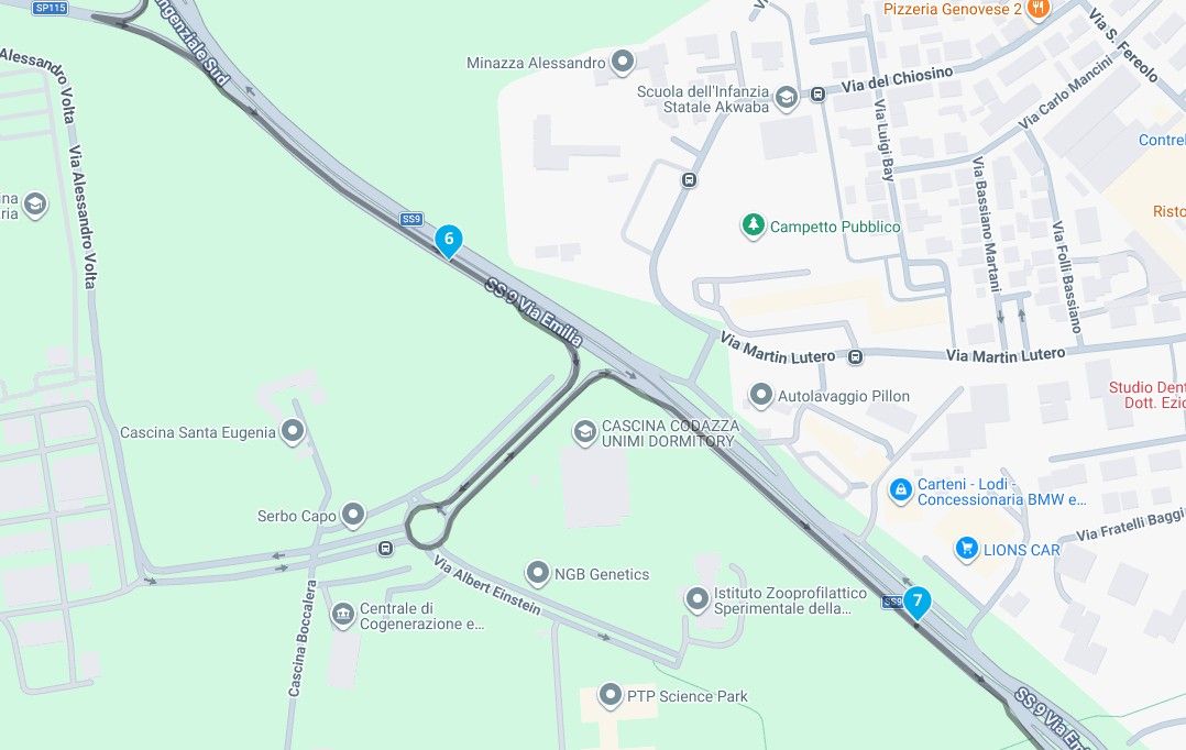
It's specifically the road after waypoint 26 that gives way longer estimates than other map sources. It's based on the realistic travel time HERE tracks for that section and my guess is that their data on that is wrong.
Either incorrect speed limit or some anomalies in their realistic travel time estimation
-
It's specifically the road after waypoint 26 that gives way longer estimates than other map sources. It's based on the realistic travel time HERE tracks for that section and my guess is that their data on that is wrong.
Either incorrect speed limit or some anomalies in their realistic travel time estimation
@Corjan-Meijerink That's interesting. Google Maps is estimating an average speed of 28 mph for the entire route which seems to be very reasonable. I have found Google Maps and Waze to be extremely accurate in their route time estimations. A greater than 1 hour discrepancy between what Google calculates to be a 3:15 minute drive is a BIG discrepancy.
I'm riding this entire route tomorrow with our local BMW riders' group at a leisurely pace and we'll be taking a 15 minute break halfway through. I'll report back with the exact time it took.
My guess is that there's something wrong with the HERE map's calculations for some reason instead of the other 4 calculations being wrong, but there's nothing like riding it to see for sure!
")
Steve Jarrell
Western North Carolina USLifetime Routeplanner Gold & Navigation Next
2025 BMW R1200GS
2025 Can-Am Spyder
DMD T865-X 8" Tablet
Garmin XT3 -
@Corjan-Meijerink That's interesting. Google Maps is estimating an average speed of 28 mph for the entire route which seems to be very reasonable. I have found Google Maps and Waze to be extremely accurate in their route time estimations. A greater than 1 hour discrepancy between what Google calculates to be a 3:15 minute drive is a BIG discrepancy.
I'm riding this entire route tomorrow with our local BMW riders' group at a leisurely pace and we'll be taking a 15 minute break halfway through. I'll report back with the exact time it took.
My guess is that there's something wrong with the HERE map's calculations for some reason instead of the other 4 calculations being wrong, but there's nothing like riding it to see for sure!
@Steve-Jarrell keep me posted!
Might also check what the navigation itself estimates once you load the track itself! (Not the converted route) -
@Steve-Jarrell keep me posted!
Might also check what the navigation itself estimates once you load the track itself! (Not the converted route)@Corjan-Meijerink I have. The route-track and just the track both are 3:15, exactly like Google and Kurviger. It's only the HERE route that's way off. I think the solution for me going forward is going to be just using the OSM map as my default and forget about using the HERE map. The HERE map seems to have limitations that the others don't for whatever reason.
Hopefully the "The selected mode only works with the HERE / TomTom map" dialog won't be displayed in a future update if I have my transport mode set to Car as we discussed in a separate post.
Thanks,
Steve
Steve Jarrell
Western North Carolina USLifetime Routeplanner Gold & Navigation Next
2025 BMW R1200GS
2025 Can-Am Spyder
DMD T865-X 8" Tablet
Garmin XT3 -
@Corjan-Meijerink I have. The route-track and just the track both are 3:15, exactly like Google and Kurviger. It's only the HERE route that's way off. I think the solution for me going forward is going to be just using the OSM map as my default and forget about using the HERE map. The HERE map seems to have limitations that the others don't for whatever reason.
Hopefully the "The selected mode only works with the HERE / TomTom map" dialog won't be displayed in a future update if I have my transport mode set to Car as we discussed in a separate post.
Thanks,
Steve
@Steve-Jarrell said in Travel time discrepancies:
The route-track and just the track both are 3:15, exactly like Google and Kurviger. It's only the HERE route that's way off
I suspect that distance and duration of tracks are values that are embedded in the track data. They won't change on any platform unless recalculated.
I am just an enthusiastic MRA user, and hope you will be one too!
Most motorcycle problems are caused by the nut that connects the handlebar to the saddle.
Check out RideSleepRepeat.eu, a biker community for sharing stays across Europe
-
@Steve-Jarrell said in Travel time discrepancies:
The route-track and just the track both are 3:15, exactly like Google and Kurviger. It's only the HERE route that's way off
I suspect that distance and duration of tracks are values that are embedded in the track data. They won't change on any platform unless recalculated.
@Con-Hennekens If I look at the .gpx file it looks like the coordinates start at 13:35 and end at 16:15. If my "clock math" is correct that's 3:40.
It does seem strange though that MRA's track, route-track, and Google's MyMap all show the same time down to the minute (they're all just using the track) so It would seem reasonable they're calculating it from the track somehow. I'm sure some of the MRA gurus could shed some light on this.We rode the route today and it took 3:20, but that included a 15 minute break and about 10 minutes in delays for road construction where they're still rebuilding roads here in Western North Carolina that were destroyed by Hurricane Helene back in late September.
That would make the actual ride time about 2:55.
Steve Jarrell
Western North Carolina USLifetime Routeplanner Gold & Navigation Next
2025 BMW R1200GS
2025 Can-Am Spyder
DMD T865-X 8" Tablet
Garmin XT3 -
@Con-Hennekens If I look at the .gpx file it looks like the coordinates start at 13:35 and end at 16:15. If my "clock math" is correct that's 3:40.
It does seem strange though that MRA's track, route-track, and Google's MyMap all show the same time down to the minute (they're all just using the track) so It would seem reasonable they're calculating it from the track somehow. I'm sure some of the MRA gurus could shed some light on this.We rode the route today and it took 3:20, but that included a 15 minute break and about 10 minutes in delays for road construction where they're still rebuilding roads here in Western North Carolina that were destroyed by Hurricane Helene back in late September.
That would make the actual ride time about 2:55.
@Steve-Jarrell, I checked some GPX files here, they all have no end-time at all, nor a duration or anything ;-). Yeah, I have seen many different formats of GPX. Especially Garmin tends to use a lot of non-standard extensions
")
I am just an enthusiastic MRA user, and hope you will be one too!
Most motorcycle problems are caused by the nut that connects the handlebar to the saddle.
Check out RideSleepRepeat.eu, a biker community for sharing stays across Europe
-
@Steve-Jarrell, I checked some GPX files here, they all have no end-time at all, nor a duration or anything ;-). Yeah, I have seen many different formats of GPX. Especially Garmin tends to use a lot of non-standard extensions
@Con-Hennekens said in Travel time discrepancies:
Especially Garmin tends to use a lot of non-standard extensions
As long as a gpx file includes corresponding namespace/schema definitions, extensions are GPX standard compliant.
Garmin extensions are widely used, even by MRA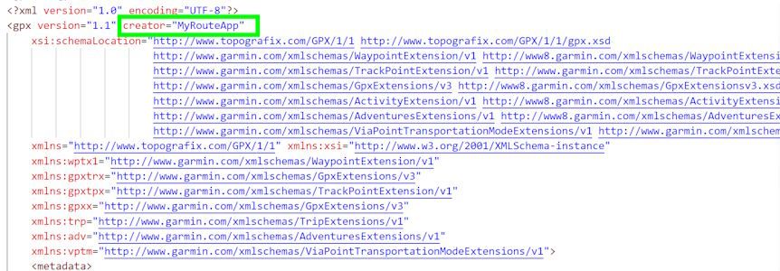
-
@Steve-Jarrell, I checked some GPX files here, they all have no end-time at all, nor a duration or anything ;-). Yeah, I have seen many different formats of GPX. Especially Garmin tends to use a lot of non-standard extensions
@Con-Hennekens Thanks. That lead me to dig a little deeper. The ride in question was created by the ride coordinator using Kurviger, then he distributed a gpx 1.1 file created by Kurviger.
This gpx file does contain time values for each gps point in the track, no doubt that coincide with the calculations the Kurviger made for the route. That's why the route in Kurviger and the track's times coincide, and why the Garmin MyMap time, the MRA track time from the imported Kurviger track file, and the MRA route-track time created from the MRA track that was imported from the Kurviger track all have exactly the same time.
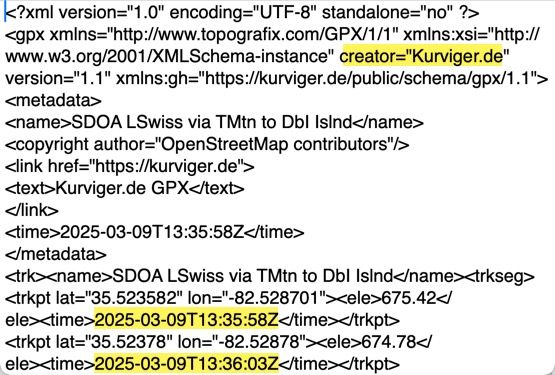
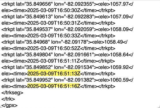
When Kurviger creates a gpx 1.1 track time it includes the time values for each gps point. When MRA creates one it does not (I double checked). However MRA, and Google MyMaps do read and use these values during import. Interesting. I've included screenshots below of the beginning and end of the 1.1 gpx file for the route that I'm talking about.
Bottom line is for this particular route Kurviger's time calculation was FAR more accurate than MRA's, especially when using the HERE map. I would think that would be worth looking into, but it's probably a low priority.
-
@Con-Hennekens said in Travel time discrepancies:
Especially Garmin tends to use a lot of non-standard extensions
As long as a gpx file includes corresponding namespace/schema definitions, extensions are GPX standard compliant.
Garmin extensions are widely used, even by MRA@Martin-Wilcke It looks like MRA is using the Garmin extensions to do their track and route calculations whereas Kurviger doesn't. The strange part is that for this exact same route if I use the OSM map in MRA the calculated time shows as 3:13, with the TomTom map it's 3:11 (both are close to the actual time that it took to ride the route and the time calculated by Google and Kurviger) and with the HERE map it is 4:17.
Gpx 1.1 files exported by all three maps show that the tracks created used the Garmin extensions, however the actual route creation calculations must be a function of the underlying map itself.
I pointed out in another post that the HERE map consistently does not follow an imported track as well as the other two, and the route's time calculations are definitely inferior as well.
I definitely see the disadvantages of using the HERE map over using the OSM map in MRA. Can anyone tell me the actual advantages?
Thanks!
Steve Jarrell
Western North Carolina USLifetime Routeplanner Gold & Navigation Next
2025 BMW R1200GS
2025 Can-Am Spyder
DMD T865-X 8" Tablet
Garmin XT3 -
@Martin-Wilcke It looks like MRA is using the Garmin extensions to do their track and route calculations whereas Kurviger doesn't. The strange part is that for this exact same route if I use the OSM map in MRA the calculated time shows as 3:13, with the TomTom map it's 3:11 (both are close to the actual time that it took to ride the route and the time calculated by Google and Kurviger) and with the HERE map it is 4:17.
Gpx 1.1 files exported by all three maps show that the tracks created used the Garmin extensions, however the actual route creation calculations must be a function of the underlying map itself.
I pointed out in another post that the HERE map consistently does not follow an imported track as well as the other two, and the route's time calculations are definitely inferior as well.
I definitely see the disadvantages of using the HERE map over using the OSM map in MRA. Can anyone tell me the actual advantages?
Thanks!
@Steve-Jarrell A small note on the side. I tried Kurviger a while ago and found the ETA's, while navigating, far too conservative (the rides were taking me less time). This was when driving a car on asfalt roads. They definitely don't include live traffic data and I think they have their own algorithm to calculate the ETA's. The ETA info to the next waypoint is a very important feature for my use cases and the conservative estimates in Kurviger were the main reason for me to switch to MRA (where I found the ETAs to be very accurate).
-
@Martin-Wilcke It looks like MRA is using the Garmin extensions to do their track and route calculations whereas Kurviger doesn't. The strange part is that for this exact same route if I use the OSM map in MRA the calculated time shows as 3:13, with the TomTom map it's 3:11 (both are close to the actual time that it took to ride the route and the time calculated by Google and Kurviger) and with the HERE map it is 4:17.
Gpx 1.1 files exported by all three maps show that the tracks created used the Garmin extensions, however the actual route creation calculations must be a function of the underlying map itself.
I pointed out in another post that the HERE map consistently does not follow an imported track as well as the other two, and the route's time calculations are definitely inferior as well.
I definitely see the disadvantages of using the HERE map over using the OSM map in MRA. Can anyone tell me the actual advantages?
Thanks!
@Steve-Jarrell said in Travel time discrepancies:
It looks like MRA is using the Garmin extensions to do their track and route calculations whereas Kurviger doesn't.
To avoid confusion: Using GPX extensions (like "Garmin extensions") is a way to store additional information in a gpx file that is not part of the core gpx data model. The most popular example is the differentiation between VIA and shaping route points using the garmin:trp extension.
For time information, however, there is no need to use an extension as this is part of the core gpx data model.
And it's about storing information and has nothing to do with time calculation.
-
@Martin-Wilcke It looks like MRA is using the Garmin extensions to do their track and route calculations whereas Kurviger doesn't. The strange part is that for this exact same route if I use the OSM map in MRA the calculated time shows as 3:13, with the TomTom map it's 3:11 (both are close to the actual time that it took to ride the route and the time calculated by Google and Kurviger) and with the HERE map it is 4:17.
Gpx 1.1 files exported by all three maps show that the tracks created used the Garmin extensions, however the actual route creation calculations must be a function of the underlying map itself.
I pointed out in another post that the HERE map consistently does not follow an imported track as well as the other two, and the route's time calculations are definitely inferior as well.
I definitely see the disadvantages of using the HERE map over using the OSM map in MRA. Can anyone tell me the actual advantages?
Thanks!
@Steve-Jarrell said in Travel time discrepancies:
I definitely see the disadvantages of using the HERE map over using the OSM map in MRA. Can anyone tell me the actual advantages?
There is one I'm aware of: consideration of road closures.
-
@Steve-Jarrell A small note on the side. I tried Kurviger a while ago and found the ETA's, while navigating, far too conservative (the rides were taking me less time). This was when driving a car on asfalt roads. They definitely don't include live traffic data and I think they have their own algorithm to calculate the ETA's. The ETA info to the next waypoint is a very important feature for my use cases and the conservative estimates in Kurviger were the main reason for me to switch to MRA (where I found the ETAs to be very accurate).
@Herman-Veldhuizen Thanks for your respons Herman. With the TomTom and OSM maps I'm finding the calculated route times to be very accurate. With the HERE maps I find it to be inconsistent.
The only thing that I can surmise is that the route calculations and the calculations that create a route from a track are built into the maps themselves and MRA has very little, if any, control over them otherwise the HERE map would not be inferior to the other two in this regard.
I also switched from Kurviger as I find the user interface to be very, very unintuitive whereas I find MRA to be extremely easy to use. I also find MRA's tech support to be excellent, and the user forum is extremely helpful as well.
Unless someone can show me why there are important advantages to using the HERE maps as the default I'm going to make the OSM maps my default, and hopefully the MRA developers will fix the bug that causes the following dialog to appear when I switch to the OSM map or import a track into it even though I have my driving mode set to "Driving" which, according to MRA, should avoid this message:

Steve Jarrell
Western North Carolina USLifetime Routeplanner Gold & Navigation Next
2025 BMW R1200GS
2025 Can-Am Spyder
DMD T865-X 8" Tablet
Garmin XT3 -
@Herman-Veldhuizen Thanks for your respons Herman. With the TomTom and OSM maps I'm finding the calculated route times to be very accurate. With the HERE maps I find it to be inconsistent.
The only thing that I can surmise is that the route calculations and the calculations that create a route from a track are built into the maps themselves and MRA has very little, if any, control over them otherwise the HERE map would not be inferior to the other two in this regard.
I also switched from Kurviger as I find the user interface to be very, very unintuitive whereas I find MRA to be extremely easy to use. I also find MRA's tech support to be excellent, and the user forum is extremely helpful as well.
Unless someone can show me why there are important advantages to using the HERE maps as the default I'm going to make the OSM maps my default, and hopefully the MRA developers will fix the bug that causes the following dialog to appear when I switch to the OSM map or import a track into it even though I have my driving mode set to "Driving" which, according to MRA, should avoid this message:
@Steve-Jarrell I never really looked at the route times, only the ETAs while navigating.
But now I did for one of my routes which goes mostly over a highway
Route time for MRA-OSM is noticeably longer than MRA-Here! Kurviger is the slowest.
220km, paths are very similar in all 3.MRA Here: 2h 52m
MRA OSM: 3h 13m
Kurviger: 4h 4m -
@Steve-Jarrell I never really looked at the route times, only the ETAs while navigating.
But now I did for one of my routes which goes mostly over a highway
Route time for MRA-OSM is noticeably longer than MRA-Here! Kurviger is the slowest.
220km, paths are very similar in all 3.MRA Here: 2h 52m
MRA OSM: 3h 13m
Kurviger: 4h 4m@Herman-Veldhuizen Thanks Herman.. That's weird..... there doesn't seem to be any consistency. My "gold standard" is normally Waze or Google maps as I find them to be extremely accurate, but since you can't upload a specific route into either they're of no help. Although you can import a track into Google MyMaps it really doesn't create a Google route from it, so it uses the tracks time information so that's no help.
I could be wrong so if I am someone please let me know. I'm here to learn.... that's half the fun!
If I have time I'll go back and compare 5 or 6 of our group's tracks/routes and compare them in MRA using the HERE, OSM and TomTom maps.
Thanks for your input. I really appreciate it!
-
@Herman-Veldhuizen Thanks for your respons Herman. With the TomTom and OSM maps I'm finding the calculated route times to be very accurate. With the HERE maps I find it to be inconsistent.
The only thing that I can surmise is that the route calculations and the calculations that create a route from a track are built into the maps themselves and MRA has very little, if any, control over them otherwise the HERE map would not be inferior to the other two in this regard.
I also switched from Kurviger as I find the user interface to be very, very unintuitive whereas I find MRA to be extremely easy to use. I also find MRA's tech support to be excellent, and the user forum is extremely helpful as well.
Unless someone can show me why there are important advantages to using the HERE maps as the default I'm going to make the OSM maps my default, and hopefully the MRA developers will fix the bug that causes the following dialog to appear when I switch to the OSM map or import a track into it even though I have my driving mode set to "Driving" which, according to MRA, should avoid this message:
@Steve-Jarrell said in Travel time discrepancies:
Unless someone can show me why there are important advantages to using the HERE maps as the default I'm going to make the OSM maps my default
The biggest advantage to use HERE maps for planning is the least chance for the planner map to be different than the navigation map. The advice is to plan your route on map that is ost equal to the one you navigate with. For MRA Navigation that is HERE, as is for Garmin devices. There are many differences in maps between OSM and HERE, especially in rural mountenesque areas.
@Steve-Jarrell said in Travel time discrepancies:
the bug that causes the following dialog to appear when I switch to the OSM map or import a track into it even though I have my driving mode set to "Driving"
I am not aware of a driving mode called "driving". I only get this message when I switch from HERE or TomTom to OSM while I have "Motorbike" selected as driving mode.
I am just an enthusiastic MRA user, and hope you will be one too!
Most motorcycle problems are caused by the nut that connects the handlebar to the saddle.
Check out RideSleepRepeat.eu, a biker community for sharing stays across Europe
-
@Steve-Jarrell said in Travel time discrepancies:
It looks like MRA is using the Garmin extensions to do their track and route calculations whereas Kurviger doesn't.
To avoid confusion: Using GPX extensions (like "Garmin extensions") is a way to store additional information in a gpx file that is not part of the core gpx data model. The most popular example is the differentiation between VIA and shaping route points using the garmin:trp extension.
For time information, however, there is no need to use an extension as this is part of the core gpx data model.
And it's about storing information and has nothing to do with time calculation.
@Martin-Wilcke Thank you for the explanation!
-
@Steve-Jarrell said in Travel time discrepancies:
I definitely see the disadvantages of using the HERE map over using the OSM map in MRA. Can anyone tell me the actual advantages?
There is one I'm aware of: consideration of road closures.
@Martin-Wilcke Thank you.
That's one that I prefer not to use anyway as I've found (in our area at least) that often it's not accurate, or I'm creating a route that I'll be riding when they don't exist so I almost always disable it anyway.
Hello! It looks like you're interested in this conversation, but you don't have an account yet.
Getting fed up of having to scroll through the same posts each visit? When you register for an account, you'll always come back to exactly where you were before, and choose to be notified of new replies (either via email, or push notification). You'll also be able to save bookmarks and upvote posts to show your appreciation to other community members.
With your input, this post could be even better 💗
Register Login-
017298
-
016416
-
7321.9k
-
9442
-
0464
-
17425
-
17400
-
015473