Suggestion - POI 30km scale
-
Would it be possible to view POIs on the 30km scale instead of the 10km scale?
Viewing the larger picture can make it easier to "see" a route between Points of Interest. It's very much like marking a paper map to see the larger picture.When I think of it, it would be nice to click on a POI and add to a route
@Wallace-Shackleton said in Suggestion - POI 30km scale:
When I think of it, it would be nice to click on a POI and add to a route
That's exactly how it works...
Click on a POI: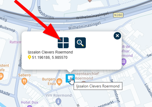
Then click where the arrow points:
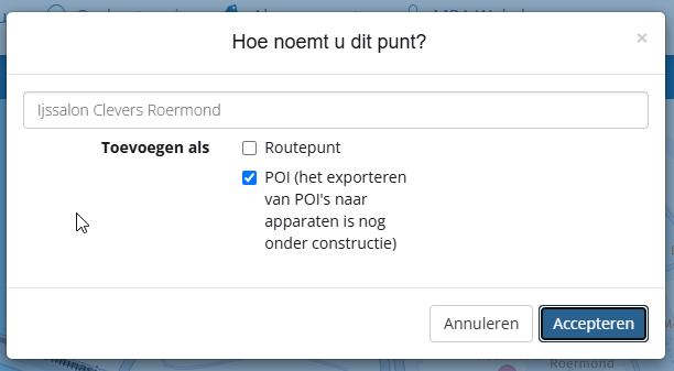
You can add the POI as just a POI or as a waypoint.
Great, isn't it?")
I am just an enthusiastic MRA user, and hope you will be one too!
Most motorcycle problems are caused by the nut that connects the handlebar to the saddle.
Check out RideSleepRepeat.eu, a biker community for sharing stays across Europe
-
@Wallace-Shackleton said in Suggestion - POI 30km scale:
When I think of it, it would be nice to click on a POI and add to a route
That's exactly how it works...
Click on a POI:Then click where the arrow points:
You can add the POI as just a POI or as a waypoint.
Great, isn't it?That's great, thanks for that. Although, in my defence"Place POI" is not that obvious what the cross actually does.
Hello! It looks like you're interested in this conversation, but you don't have an account yet.
Getting fed up of having to scroll through the same posts each visit? When you register for an account, you'll always come back to exactly where you were before, and choose to be notified of new replies (either via email, or push notification). You'll also be able to save bookmarks and upvote posts to show your appreciation to other community members.
With your input, this post could be even better 💗
Register Login-
014191
-
0606.5k
-
1906.1k
-
0536
-
011179
-
024732
-
0350
-
255612.9k