Import Coordinates/Excel data
-
Have searched and couldn't find previous history - is it possible to import coordinate data sets, from an excel spreadsheet, for example, into the planner?
-
Have searched and couldn't find previous history - is it possible to import coordinate data sets, from an excel spreadsheet, for example, into the planner?
@GT-JWR
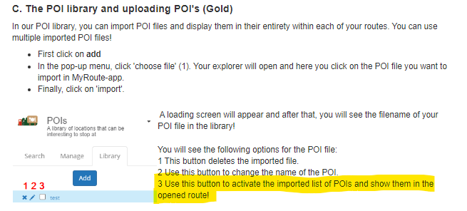
Yes you can. create a csv file with the data like this
-4.4740426540375,57.522252802735,"The Singleton of Glen Ord Distillery, Visitor Centre & Whisky Shop",""
Import the file as a POI file.Garmin Zumo XT3/XT2/XT/BMW Connected Ride Navigator/MyRouteapp (The App)/...
Een dag niet gelachen is een dag niet geleefd / Een route is net zo goed als deze uitgezet is. -
@GT-JWR
Yes you can. create a csv file with the data like this
-4.4740426540375,57.522252802735,"The Singleton of Glen Ord Distillery, Visitor Centre & Whisky Shop",""
Import the file as a POI file.@Hans-van-de-Ven-MR-MRA thanks.
-
@GT-JWR
Yes you can. create a csv file with the data like this
-4.4740426540375,57.522252802735,"The Singleton of Glen Ord Distillery, Visitor Centre & Whisky Shop",""
Import the file as a POI file.@Hans-van-de-Ven-MR-MRA I have successfully created and imported a *.csv file into POI.
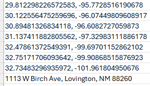

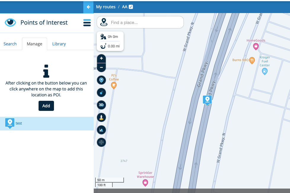
However, I am not having any success with the coordinates showing up in/along the planned route - what am I missing?
For example, the 4th set of coordinates should show up where the yellow highlighted circle is...
-
@Hans-van-de-Ven-MR-MRA I have successfully created and imported a *.csv file into POI.
However, I am not having any success with the coordinates showing up in/along the planned route - what am I missing?
For example, the 4th set of coordinates should show up where the yellow highlighted circle is...
@GT-JWR
Add the name like in the exampleGarmin Zumo XT3/XT2/XT/BMW Connected Ride Navigator/MyRouteapp (The App)/...
Een dag niet gelachen is een dag niet geleefd / Een route is net zo goed als deze uitgezet is. -
@GT-JWR
Add the name like in the example@Hans-van-de-Ven-MR-MRA when I click on 'Add', it simply wants me to re-import the file - it does not add it to the route map.

-
@Hans-van-de-Ven-MR-MRA when I click on 'Add', it simply wants me to re-import the file - it does not add it to the route map.
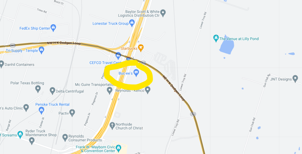
@GT-JWR use the 3 bar menu (top left side) to display points of interest.
2010 GL1800 Goldwing using Samsung Galaxy S20 5G Android 13.
-
@GT-JWR use the 3 bar menu (top left side) to display points of interest.
@RetiredWingMan I did...see this image above.
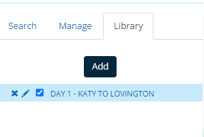
Clicking on 'Add' does nothing except wanting to re-import the file - absolutely no coordinates from that file get added to the map I am wanting to add them to.
Something's missing? -
@RetiredWingMan I did...see this image above.
Clicking on 'Add' does nothing except wanting to re-import the file - absolutely no coordinates from that file get added to the map I am wanting to add them to.
Something's missing?@GT-JWR when you go back to the map your POIs should appear. You may have to zoom in a bit for them to appear.
-
hi @GT-JWR
i have just used the top co-ordinate that you put in the screen shot
29.812298226572583, -95.7728516190678and this was the rsult when i added it as a POI, obviously the blue square, i just named it test for a sample.
so this seems to work for me.
to achieve, we must first attempt ✌️
K1600 GTL
Oukitel RT3
iPhone 13 Pro, carpuride 702b -
hi @GT-JWR
i have just used the top co-ordinate that you put in the screen shot
29.812298226572583, -95.7728516190678and this was the rsult when i added it as a POI, obviously the blue square, i just named it test for a sample.
so this seems to work for me.
@paul69 @RetiredWingMan - appreciate the advice.
Perhaps I need to clarify, to make sure I understand what takes place vs what is supposed to take place.
If I have a *.csv file, that has 20 coordinates it it, for example, what are the steps? My understanding of what should happen:
- click on POI, which opens 3 options.... Search, Manage & Library.
- go to Library, click on Add...select the *.csv file, and it imports
- place a check in the box, and ALL coordinates in that file should now show on the map.
Is this correct?
None of the coordinates show up, even when zoomed in.
According to the Manual in loading POI's, it should work.
-
hi @GT-JWR
apologies but I am unable to help any further, I do not normally use this function, I only tried it to see if it worked for me.
somebody with a lot more experience than I will be along to help you, of that, I am sure.
-
@paul69 @RetiredWingMan - appreciate the advice.
Perhaps I need to clarify, to make sure I understand what takes place vs what is supposed to take place.
If I have a *.csv file, that has 20 coordinates it it, for example, what are the steps? My understanding of what should happen:
- click on POI, which opens 3 options.... Search, Manage & Library.
- go to Library, click on Add...select the *.csv file, and it imports
- place a check in the box, and ALL coordinates in that file should now show on the map.
Is this correct?
None of the coordinates show up, even when zoomed in.
According to the Manual in loading POI's, it should work.
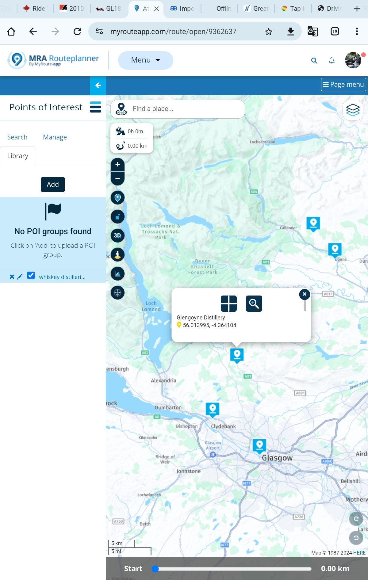
@GT-JWR as you can see in the screen shot below, I added a POI list of distilleries in Scotland. When I zoom in sufficiently, they appear on the planning map. The only thing I can think of is that your file of POIs does not include all of the data required to properly create the POIs. You did not replicate the example in June of the first responses. Your missing a name for the POI as well as a trailing text field.

2010 GL1800 Goldwing using Samsung Galaxy S20 5G Android 13.
-
@GT-JWR as you can see in the screen shot below, I added a POI list of distilleries in Scotland. When I zoom in sufficiently, they appear on the planning map. The only thing I can think of is that your file of POIs does not include all of the data required to properly create the POIs. You did not replicate the example in June of the first responses. Your missing a name for the POI as well as a trailing text field.
@RetiredWingMan I will input names and see if that brings me success! Thanks.
-
@RetiredWingMan I will input names and see if that brings me success! Thanks.
Download this file as: POI.csv
https://www.facebook.com/share/p/BPkBZXz1GWxdUjU1/And then upload it as POi
Garmin Zumo XT3/XT2/XT/BMW Connected Ride Navigator/MyRouteapp (The App)/...
Een dag niet gelachen is een dag niet geleefd / Een route is net zo goed als deze uitgezet is. -
Download this file as: POI.csv
https://www.facebook.com/share/p/BPkBZXz1GWxdUjU1/And then upload it as POi
@Hans-van-de-Ven-MR-MRA I did that - the link opens MRA directly, and all POI's are there.
So then out of curiousity, I went to the 'Files' on that FB page, found this file, Afsluitingen_NLD_20220118.csv, and when saving to my PC, noticed it was a 'CSV UTF-8' file. Thinking this might have something to do with the issue I'm having, I also saved it as a simple '*,CSV' file.
Then added both to my POI list, both opened up and showed as expected.
Perhaps I have something wrong with the file I am trying to load?
...tried to copy file here, saying I don't have enough privelages...will try to copy in a 2nd reply.
-
@Hans-van-de-Ven-MR-MRA I did that - the link opens MRA directly, and all POI's are there.
So then out of curiousity, I went to the 'Files' on that FB page, found this file, Afsluitingen_NLD_20220118.csv, and when saving to my PC, noticed it was a 'CSV UTF-8' file. Thinking this might have something to do with the issue I'm having, I also saved it as a simple '*,CSV' file.
Then added both to my POI list, both opened up and showed as expected.
Perhaps I have something wrong with the file I am trying to load?
...tried to copy file here, saying I don't have enough privelages...will try to copy in a 2nd reply.
@Hans-van-de-Ven-MR-MRA ...well, appears I cannot attach the file...

Hello! It looks like you're interested in this conversation, but you don't have an account yet.
Getting fed up of having to scroll through the same posts each visit? When you register for an account, you'll always come back to exactly where you were before, and choose to be notified of new replies (either via email, or push notification). You'll also be able to save bookmarks and upvote posts to show your appreciation to other community members.
With your input, this post could be even better 💗
Register Login-
1733.4k
-
0674
-
3642
-
0655
-
08136
-
013648
-
2427
-
0340