Import von Wegpunkten (POI) aus Basecamp nach MRA - Notizenfeldinhalte gehen verloren
-
Hallo, ich habe in grosses Problem mit diesem sonst sehr guten Programm.
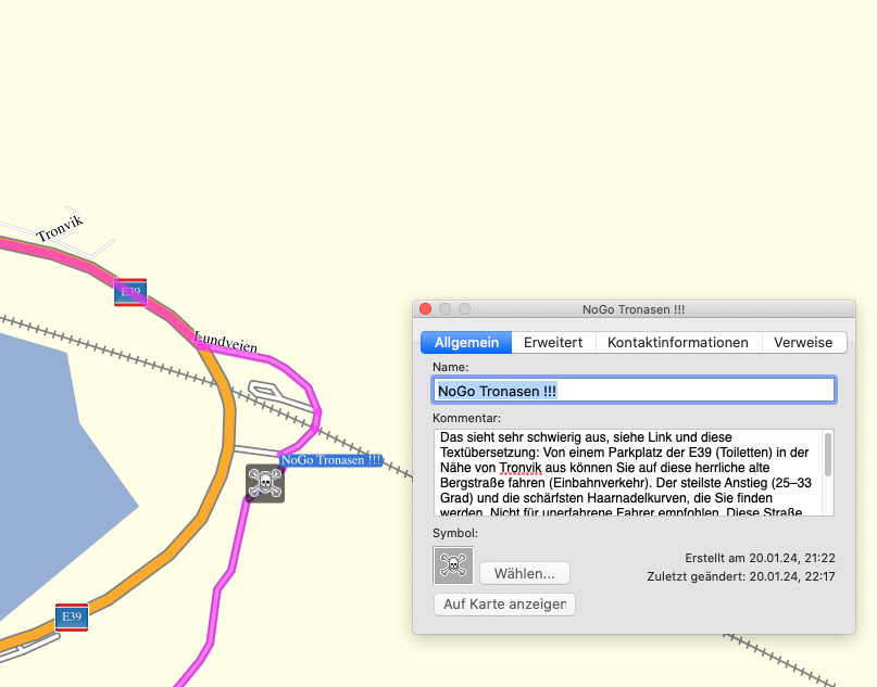
Beim Import einer gpx-Datei aus dem Export von BaseCamp gehen die Inhalte im Feld Notizen (in BaseCamp) verloren. Es wird nur die Namenszeile der POI in MRA übernommen. Damit wird MRA für mich unbrauchbar da ich mehrere Hundert davon in den Jahren gesammelt habe.
Ein Beispiel:

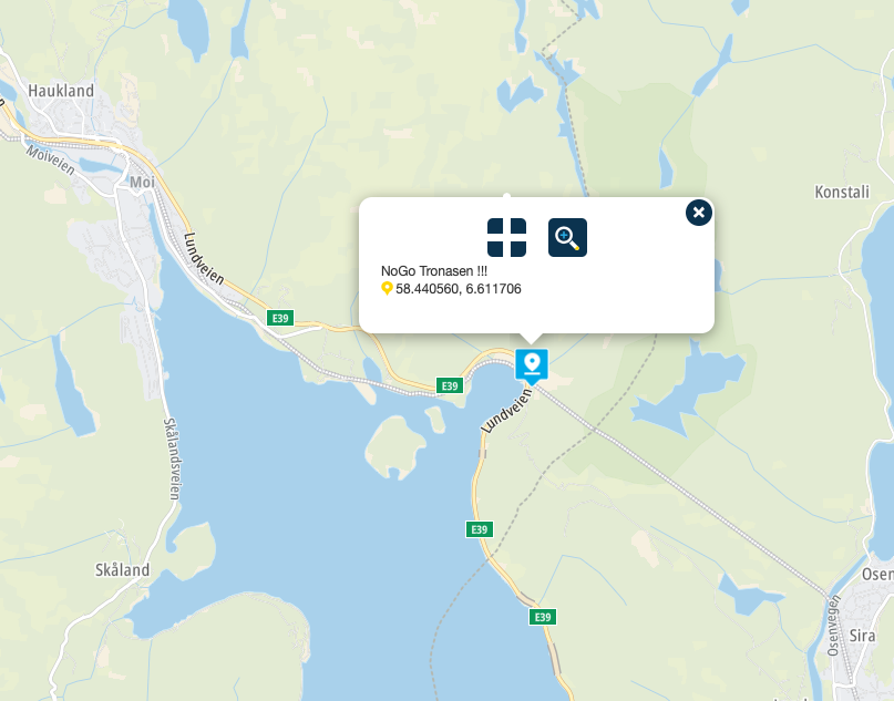
Nach dem Import dieses (und anderer Punkte) in MRA bleibt dort nur noch das übrig:

Wie man sieht gehen die im Fenster Kommentar erstellten Notizen verloren.Sollte das nicht möglich sein diese mit zu importieren ist MRA nicht die richtige App für mich. Aber ich habe Hoffnung das man mir hier einen Weg aufzeichnen kann wie das geht.
Grüße an alle
Klaus aus NRW -
@Peter-Schiefer Danke Peter für die Erklärungen - ich habe das auch nicht mit CSV hinbekommen. Ich wollte aber einmal mit einem Macrorecorder für Windows oder Mac probieren - hatte aber noch keine Zeit
-
@Peter-Schiefer Danke Peter für die Erklärungen - ich habe das auch nicht mit CSV hinbekommen. Ich wollte aber einmal mit einem Macrorecorder für Windows oder Mac probieren - hatte aber noch keine Zeit
@RideOnWithFriends
Hallo Peter, herzlichen Dank für die schnelle und ausführliche Antwort. Damit wird mir einiges klarer.
Schade, ich habe gedacht in der modernen Computerwelt müsste das doch möglich, ZUMAL ja in MRA selber die Möglichkeit besteht zu Wegpunkten nicht nur Namen sondern auch "Anmerkungen" zu vergeben, allerdings wohl mit begrenzter Zeichenanzahl.
MRA scheint mir ein tolles Naviprogramm zu sein, aber es ist sehr verwirrend und wenig intuitiv wenn man von BaseCamp kommt. Damit werde ich wohl auch weiterhin planen, aber dann mit dem Export File in MRA navigieren.
Ich habe ja als Gold-Mitglied auch noch mehr als 11 Monate Zeit mir das Wissen um MRA anzueigen. Mit BaseCamp war das am Anfang ja auch so.Vielen Dank
Klaus -
Hallo, ich habe in grosses Problem mit diesem sonst sehr guten Programm.
Beim Import einer gpx-Datei aus dem Export von BaseCamp gehen die Inhalte im Feld Notizen (in BaseCamp) verloren. Es wird nur die Namenszeile der POI in MRA übernommen. Damit wird MRA für mich unbrauchbar da ich mehrere Hundert davon in den Jahren gesammelt habe.
Ein Beispiel:

Nach dem Import dieses (und anderer Punkte) in MRA bleibt dort nur noch das übrig:

Wie man sieht gehen die im Fenster Kommentar erstellten Notizen verloren.Sollte das nicht möglich sein diese mit zu importieren ist MRA nicht die richtige App für mich. Aber ich habe Hoffnung das man mir hier einen Weg aufzeichnen kann wie das geht.
Grüße an alle
Klaus aus NRW@Klaus-Huber, can you check if the note-field exists in a GPX export made by BaseCamp? If it is, it is like @Peter-Schiefer explained, not conform the GPX standard, but nevertheless the MRA import routine could be adapted to honor that field if it exists. I think the MRA devs will be open to this suggestion (and most likely small change), if it can bring in more BaseCamp users to the MRA alternative.
-
@Klaus-Huber, can you check if the note-field exists in a GPX export made by BaseCamp? If it is, it is like @Peter-Schiefer explained, not conform the GPX standard, but nevertheless the MRA import routine could be adapted to honor that field if it exists. I think the MRA devs will be open to this suggestion (and most likely small change), if it can bring in more BaseCamp users to the MRA alternative.
@Con-Hennekens
It ist like you descripe it ! maybe MRA will do it in the future.
The Hope Never Never goes away.
Klaus -
@Con-Hennekens
It ist like you descripe it ! maybe MRA will do it in the future.
The Hope Never Never goes away.
Klaus@Klaus-Huber, indeed, but for it to happen at all, the note will have to show up in a GPX export first. The export of a GPX file from BaseCamp of a small test route that contains a waypoint with a note could prove that.
-
@Klaus-Huber, indeed, but for it to happen at all, the note will have to show up in a GPX export first. The export of a GPX file from BaseCamp of a small test route that contains a waypoint with a note could prove that.
@Con-Hennekens
It is as you can see:
<?xml version="1.0"?>
<gpx xmlns="http://www.topografix.com/GPX/1/1" xmlns:xsi="http://www.w3.org/2001/XMLSchema-instance" xmlns:wptx1="http://www.garmin.com/xmlschemas/WaypointExtension/v1" xmlns:gpxtrx="http://www.garmin.com/xmlschemas/GpxExtensions/v3" xmlns:gpxtpx="http://www.garmin.com/xmlschemas/TrackPointExtension/v1" xmlns:gpxx="http://www.garmin.com/xmlschemas/GpxExtensions/v3" xmlns:trp="http://www.garmin.com/xmlschemas/TripExtensions/v1" xmlns:adv="http://www.garmin.com/xmlschemas/AdventuresExtensions/v1" xmlns:prs="http://www.garmin.com/xmlschemas/PressureExtension/v1" xmlns:tmd="http://www.garmin.com/xmlschemas/TripMetaDataExtensions/v1" xmlns:vptm="http://www.garmin.com/xmlschemas/ViaPointTransportationModeExtensions/v1" xmlns:ctx="http://www.garmin.com/xmlschemas/CreationTimeExtension/v1" xmlns:gpxacc="http://www.garmin.com/xmlschemas/AccelerationExtension/v1" xmlns:gpxpx="http://www.garmin.com/xmlschemas/PowerExtension/v1" xmlns:vidx1="http://www.garmin.com/xmlschemas/VideoExtension/v1" creator="Garmin Desktop App" version="1.1" xsi:schemaLocation="http://www.topografix.com/GPX/1/1 http://www.topografix.com/GPX/1/1/gpx.xsd http://www.garmin.com/xmlschemas/WaypointExtension/v1 http://www8.garmin.com/xmlschemas/WaypointExtensionv1.xsd http://www.garmin.com/xmlschemas/TrackPointExtension/v1 http://www.garmin.com/xmlschemas/TrackPointExtensionv1.xsd http://www.garmin.com/xmlschemas/GpxExtensions/v3 http://www8.garmin.com/xmlschemas/GpxExtensionsv3.xsd http://www.garmin.com/xmlschemas/ActivityExtension/v1 http://www8.garmin.com/xmlschemas/ActivityExtensionv1.xsd http://www.garmin.com/xmlschemas/AdventuresExtensions/v1 http://www8.garmin.com/xmlschemas/AdventuresExtensionv1.xsd http://www.garmin.com/xmlschemas/PressureExtension/v1 http://www.garmin.com/xmlschemas/PressureExtensionv1.xsd http://www.garmin.com/xmlschemas/TripExtensions/v1 http://www.garmin.com/xmlschemas/TripExtensionsv1.xsd http://www.garmin.com/xmlschemas/TripMetaDataExtensions/v1 http://www.garmin.com/xmlschemas/TripMetaDataExtensionsv1.xsd http://www.garmin.com/xmlschemas/ViaPointTransportationModeExtensions/v1 http://www.garmin.com/xmlschemas/ViaPointTransportationModeExtensionsv1.xsd http://www.garmin.com/xmlschemas/CreationTimeExtension/v1 http://www.garmin.com/xmlschemas/CreationTimeExtensionsv1.xsd http://www.garmin.com/xmlschemas/AccelerationExtension/v1 http://www.garmin.com/xmlschemas/AccelerationExtensionv1.xsd http://www.garmin.com/xmlschemas/PowerExtension/v1 http://www.garmin.com/xmlschemas/PowerExtensionv1.xsd http://www.garmin.com/xmlschemas/VideoExtension/v1 http://www.garmin.com/xmlschemas/VideoExtensionv1.xsd">
<metadata>
<link href="http://www.garmin.com">
<text>Garmin International</text>
</link>
<time>2024-04-07T22:41:51Z</time>
<bounds maxlat="51.961097996681929" maxlon="7.965689627453685" minlat="51.961097996681929" minlon="7.965689627453685"/>
</metadata>
<wpt lat="51.961097996681929" lon="7.965689627453685">
<time>2023-02-06T16:19:14Z</time>
<name>Wertstoffhof 113</name>
<cmt>Neuwarendorf 113
Warendorf, Warendorf, 48231, DEU
Dieser ist freitags von 13 bis 16 Uhr sowie samstags von 9 bis 13 Uhr geöffnet.</cmt>
<desc>Neuwarendorf 113
Warendorf, Warendorf, 48231, DEU
Dieser ist freitags von 13 bis 16 Uhr sowie samstags von 9 bis 13 Uhr geöffnet.</desc>
<sym>Circle, Red</sym>
<type>user</type>
<extensions>
gpxx:WaypointExtension
gpxx:DisplayModeSymbolAndName</gpxx:DisplayMode>
gpxx:Address
gpxx:StreetAddressNeuwarendorf 113</gpxx:StreetAddress>
gpxx:CityWarendorf</gpxx:City>
gpxx:StateWarendorf</gpxx:State>
gpxx:CountryDEU</gpxx:Country>
gpxx:PostalCode48231</gpxx:PostalCode>
</gpxx:Address>
</gpxx:WaypointExtension>
wptx1:WaypointExtension
wptx1:DisplayModeSymbolAndName</wptx1:DisplayMode>
wptx1:Address
wptx1:StreetAddressNeuwarendorf 113</wptx1:StreetAddress>
wptx1:CityWarendorf</wptx1:City>
wptx1:StateWarendorf</wptx1:State>
wptx1:CountryDEU</wptx1:Country>
wptx1:PostalCode48231</wptx1:PostalCode>
</wptx1:Address>
</wptx1:WaypointExtension>
ctx:CreationTimeExtension
ctx:CreationTime2023-02-06T16:19:14Z</ctx:CreationTime>
</ctx:CreationTimeExtension>
</extensions>
</wpt>
</gpx>I wonder that it is two times there but that is not a problem (only on the Garmin Zumo because there you get this text two times in on window.
-
@Peter-Schiefer, I see. Well then, it is up to the devs if they choose to make that adjustment

