Ben niet blij met de nieuwe HERE kaart!
-
Wat een onduidelijke kaart nu!
De "oude" was veel beter en kon je duidelijk het verschil zien tussen de rode snel- en hoofdwegen, gele doorgaande wegen, de witte wat meer binnenwegen en daar onder de smallere wegen en onverharde wegen. Zelfs wandelpaden konden gezien worden. De huidige kaar is veel te onduidelijk. -
Het is zeker een verandering!
Wel in lijn met de kaart zoals gebruikt in de app - ook is dit de nieuwe officiële kaart die we ook moeten gaan gebruiken (de oude wordt niet meer ondersteund binnenkort).We hebben echter al wel meerdere verbeterpunten aangeleverd met anderen
")
-
Wat een onduidelijke kaart nu!
De "oude" was veel beter en kon je duidelijk het verschil zien tussen de rode snel- en hoofdwegen, gele doorgaande wegen, de witte wat meer binnenwegen en daar onder de smallere wegen en onverharde wegen. Zelfs wandelpaden konden gezien worden. De huidige kaar is veel te onduidelijk.@Dwars Dan kan je jezelf nog steeds trakteren op een andere kaart. Selecteer simpel een andere overlay (Michelin, OSM of TomTom) en je kan helemaal los met alle kleurtjes. De hoofdkaart voor de route berekening is dan nog steeds Here (TT of OSM). En aan de wandelpaden of onverharde wegen heb je toch al niets in de Here-kaart omdat de meeste simpelweg ontbreken en de navigatie over dat soort wegverharding niet wordt ondersteund.
🏍️ BMW K1600GT-P (2013) | Nolan N100-5 with Sena 30K
📱 iOS on iPhone 13 & 16 (mounted on Quadlock or AliExpress extention on BMW-cradle)
🚙 Apple CarPlay in VW T-Roc
💻 Routelab on MacBook Air & iMac (Tahoe & Ventura) -
@Dwars Dan kan je jezelf nog steeds trakteren op een andere kaart. Selecteer simpel een andere overlay (Michelin, OSM of TomTom) en je kan helemaal los met alle kleurtjes. De hoofdkaart voor de route berekening is dan nog steeds Here (TT of OSM). En aan de wandelpaden of onverharde wegen heb je toch al niets in de Here-kaart omdat de meeste simpelweg ontbreken en de navigatie over dat soort wegverharding niet wordt ondersteund.
@Rob-Verhoeff Van de overlay snap ik Rob ik werk er vaker mee, alleen als je daar een route mee maakt en je zet hem terug in HERE "stand" dan staan de waypoints niet meer correct. Nu zijn bij de nieuwe kaart alle lijnen blauw/grijs en dat maakt het niet duidelijker vind ik. Maar jij vind de nieuwe kaart wel duidelijker begrijp ik?
-
@Rob-Verhoeff Van de overlay snap ik Rob ik werk er vaker mee, alleen als je daar een route mee maakt en je zet hem terug in HERE "stand" dan staan de waypoints niet meer correct. Nu zijn bij de nieuwe kaart alle lijnen blauw/grijs en dat maakt het niet duidelijker vind ik. Maar jij vind de nieuwe kaart wel duidelijker begrijp ik?
@Dwars said in Ben niet blij met de nieuwe HERE kaart!:
Maar jij vind de nieuwe kaart wel duidelijker begrijp ik?
Zeker niet, alleen jij gebruikt de overlay dan verkeerd. Als je op bijv. de Michelinkaart een route uitzet, dan ontstaat er een lijn tussen de twee routepunten. Die lijn is gebaseerd op de Here-kaart. Staan je routepunten dan precies op de lijn, dan maakt het mij niet uit dat hij op de overlay naast de weg staat. In Here staat hij dan altijd goed. Probeer het maar eens.
En wat die Here kaart betreft, MRA moet wel mee omdat de oude kaart straks niet meer wordt ondersteund zoals Corjan al antwoordde.
🏍️ BMW K1600GT-P (2013) | Nolan N100-5 with Sena 30K
📱 iOS on iPhone 13 & 16 (mounted on Quadlock or AliExpress extention on BMW-cradle)
🚙 Apple CarPlay in VW T-Roc
💻 Routelab on MacBook Air & iMac (Tahoe & Ventura) -
@Dwars said in Ben niet blij met de nieuwe HERE kaart!:
Maar jij vind de nieuwe kaart wel duidelijker begrijp ik?
Zeker niet, alleen jij gebruikt de overlay dan verkeerd. Als je op bijv. de Michelinkaart een route uitzet, dan ontstaat er een lijn tussen de twee routepunten. Die lijn is gebaseerd op de Here-kaart. Staan je routepunten dan precies op de lijn, dan maakt het mij niet uit dat hij op de overlay naast de weg staat. In Here staat hij dan altijd goed. Probeer het maar eens.
En wat die Here kaart betreft, MRA moet wel mee omdat de oude kaart straks niet meer wordt ondersteund zoals Corjan al antwoordde.
@Rob-Verhoeff
I also create my routes according to the "Here map and the Michelin overlay" scheme described above. After I change the overlay from Michelin to Here, some route points are next to the actual route. I then correct this.
My question: The screenshot shows a section of a fictitious route. The two route points 3 and 4 are visually next to the actual route. What is technically relevant now? The position of the blue route points 3 and 4 or the two small black dots on the route (red marking)?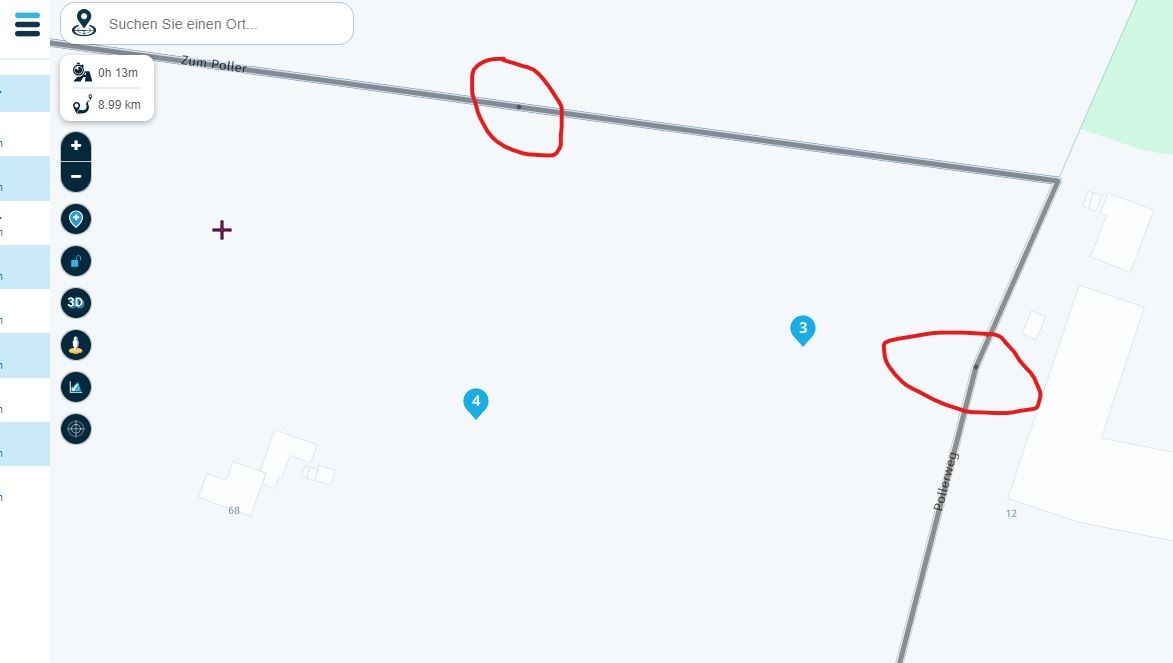
-
@Rob-Verhoeff
I also create my routes according to the "Here map and the Michelin overlay" scheme described above. After I change the overlay from Michelin to Here, some route points are next to the actual route. I then correct this.
My question: The screenshot shows a section of a fictitious route. The two route points 3 and 4 are visually next to the actual route. What is technically relevant now? The position of the blue route points 3 and 4 or the two small black dots on the route (red marking)?@Mopetenpit, Move your WP's to the corresponding black dots. If you do that, your WP is correct ON the HERE map. No matter the layer you use.
@Corjan-Meijerink, I agree that @Dwars has a point. I mentioned it before, about the navigational map in the app, that it lacks contrast and environmental information that makes it recognize the reality. I really don't understand the choices HERE makes in this regard. I would really like adding a more topographical map, or a layer like the Michelin in the app too (I use it a lot in the planner, like @Rob-Verhoeff does).
Also, as I understand it, there once was a method in the planner to set a default for the layer to be used, but it got removed. I am unaware of the reasoning behind the removal, but maybe that needs to be reconsidered.
I am just an enthusiastic MRA user, and hope you will be one too!
Most motorcycle problems are caused by the nut that connects the handlebar to the saddle.
Check out RideSleepRepeat.eu, a biker community for sharing stays across Europe
-
@Mopetenpit, Move your WP's to the corresponding black dots. If you do that, your WP is correct ON the HERE map. No matter the layer you use.
@Corjan-Meijerink, I agree that @Dwars has a point. I mentioned it before, about the navigational map in the app, that it lacks contrast and environmental information that makes it recognize the reality. I really don't understand the choices HERE makes in this regard. I would really like adding a more topographical map, or a layer like the Michelin in the app too (I use it a lot in the planner, like @Rob-Verhoeff does).
Also, as I understand it, there once was a method in the planner to set a default for the layer to be used, but it got removed. I am unaware of the reasoning behind the removal, but maybe that needs to be reconsidered.
@Con-Hennekens said in Ben niet blij met de nieuwe HERE kaart!:
Move your WP's to the corresponding black dots. If you do that, your WP is correct ON the HERE map. No matter the layer you use.
Yes, I am familiar with this procedure and I do it the same way. My actual question is: Which X-Y coordinates are in the GPX files? The coordinates for the blue route points or those for the small black ones on the route? Can you answer that?
-
@Con-Hennekens said in Ben niet blij met de nieuwe HERE kaart!:
Move your WP's to the corresponding black dots. If you do that, your WP is correct ON the HERE map. No matter the layer you use.
Yes, I am familiar with this procedure and I do it the same way. My actual question is: Which X-Y coordinates are in the GPX files? The coordinates for the blue route points or those for the small black ones on the route? Can you answer that?
@Mopetenpit I don't think the black dots are actually anything "real", I think that's just a display artefact of two semi-transparent line-segments overlapping slightly.
A GPX file can contain both a route (basically a list of waypoints) and a track (lots of "points" based on a calculated or recorded route).
The waypoints (blue) you place on the map will be in the GPX as part of the route. If you use a GPX-format that also contains a track, it will contain coordinates of many "points", enough to exactly represent the black line that's been calculated (in this case using HERE).
So in a sense, both the blue points and the "black points" will be in the GPX. If your navigation device/app uses the route, it will use the blue waypoints to calculate a route on the device, which may differ from the line you see in the planner (and the black points/lines do not matter). If your device/app uses the track, it will just use that (and the blue waypoints don't matter).
-
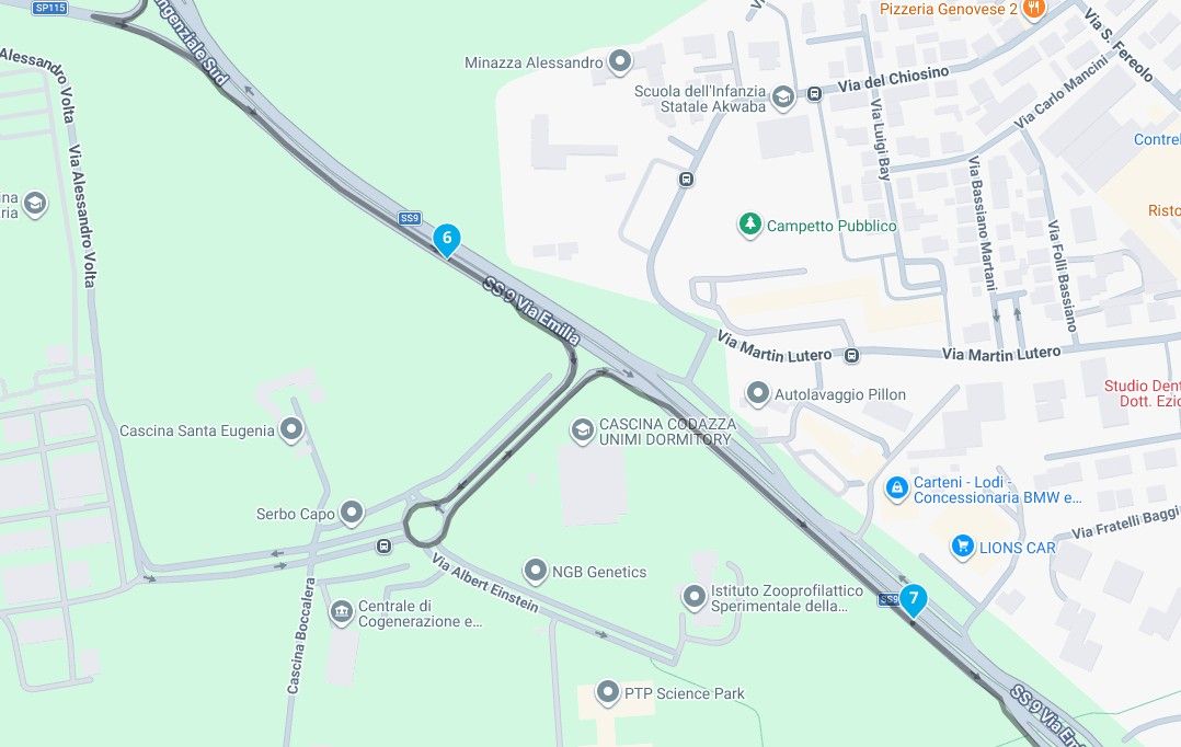
Zo te zien loopt de nieuwe HERE layout ook niet overeen met de daadwerkelijke route gemaakt in HERE… Dat is toch wel een beetje vreemd…
Hier een voorbeeld
The adventure starts where the plans end | READY TO >> RACE 🧡
-
Zo te zien loopt de nieuwe HERE layout ook niet overeen met de daadwerkelijke route gemaakt in HERE… Dat is toch wel een beetje vreemd…
Hier een voorbeeld
@CD130 Heel vreemd inderdaad. Aantal situaties bij mij in de buurt geprobeerd en daar loopt de route gewoon netjes over de kaart.
Jouw stukje route loopt op geen enkele kaartlaag correct (met HERE als onderlaag), dus wat daar aan de hand is...
-
@Con-Hennekens said in Ben niet blij met de nieuwe HERE kaart!:
Move your WP's to the corresponding black dots. If you do that, your WP is correct ON the HERE map. No matter the layer you use.
Yes, I am familiar with this procedure and I do it the same way. My actual question is: Which X-Y coordinates are in the GPX files? The coordinates for the blue route points or those for the small black ones on the route? Can you answer that?
@Mopetenpit, That is an intriguing question...
")
I am quite confident that the stored coordinate is the one that represents the WP and not the black dot. That is easily argumented, because the WP comes back at the same place when exporting and re-importing a GPX file. The black dot is a calculated coordinate that fixes the WP coordinate to a routable road.However: because I hate to talk bullshit I actually exported a GPX file to check if not also the black dot coordinate is present in the file.
Each WP seems to be represented by a single coordinate in the route data of the GPX file, but I had some trouble recognizing it. It seems the coordinate in the file has a lot more digits than the ones shown in the WP info in the planner
(red oval)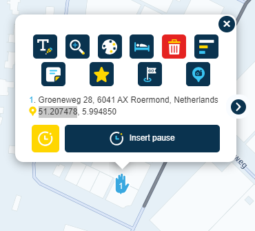
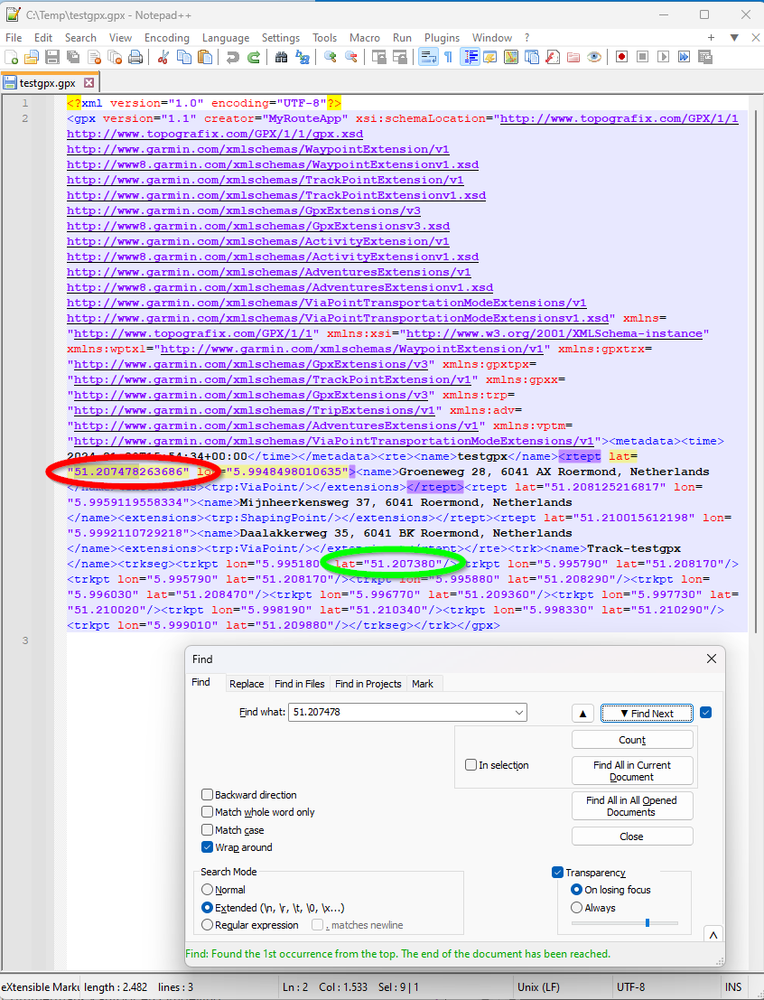
If you look at the Track information in the same file you can see that the first coordinate (green circle) is not equal (besides that LATitude and LONgitude have been flipped? Why...). This is quite logical, since the breadcrum over the routeline is represented, and not the waypoints. I think for at least the first and the last WP of a route the track-coordinate will be exactly the black dot. How the breadcrums in between these point are calculated, I have no idea. But for the start en endpoint I checked them in Google maps and they seem to correspond. Just flip LAT and LON, else you will and up somewhere off the coast of Somalia...

I am just an enthusiastic MRA user, and hope you will be one too!
Most motorcycle problems are caused by the nut that connects the handlebar to the saddle.
Check out RideSleepRepeat.eu, a biker community for sharing stays across Europe
-
@Mopetenpit, That is an intriguing question...
I am quite confident that the stored coordinate is the one that represents the WP and not the black dot. That is easily argumented, because the WP comes back at the same place when exporting and re-importing a GPX file. The black dot is a calculated coordinate that fixes the WP coordinate to a routable road.However: because I hate to talk bullshit I actually exported a GPX file to check if not also the black dot coordinate is present in the file.
Each WP seems to be represented by a single coordinate in the route data of the GPX file, but I had some trouble recognizing it. It seems the coordinate in the file has a lot more digits than the ones shown in the WP info in the planner
(red oval)If you look at the Track information in the same file you can see that the first coordinate (green circle) is not equal (besides that LATitude and LONgitude have been flipped? Why...). This is quite logical, since the breadcrum over the routeline is represented, and not the waypoints. I think for at least the first and the last WP of a route the track-coordinate will be exactly the black dot. How the breadcrums in between these point are calculated, I have no idea. But for the start en endpoint I checked them in Google maps and they seem to correspond. Just flip LAT and LON, else you will and up somewhere off the coast of Somalia...
@Con-Hennekens Lat and Lon aren't actually flipped, just the order in which they happen to be present in the file differs from the routepoint to the trackpoint. For both, lat is still 51.x, while lon is 5.x, so no we're not in Somalia.
And like I said, I don't think there's a black dot at all, just the overlap of two semi-transparent lines. There's no "black dot" at the start of the line.
-
@CD130 Heel vreemd inderdaad. Aantal situaties bij mij in de buurt geprobeerd en daar loopt de route gewoon netjes over de kaart.
Jouw stukje route loopt op geen enkele kaartlaag correct (met HERE als onderlaag), dus wat daar aan de hand is...
@Herko-ter-Horst said in Ben niet blij met de nieuwe HERE kaart!:
Jouw stukje route loopt op geen enkele kaartlaag correct (met HERE als onderlaag), dus wat daar aan de hand is...
Ik verdenk hem ervan dat hij toch stiekem buiten de gebaande paden heeft gereden
🏍️ BMW K1600GT-P (2013) | Nolan N100-5 with Sena 30K
📱 iOS on iPhone 13 & 16 (mounted on Quadlock or AliExpress extention on BMW-cradle)
🚙 Apple CarPlay in VW T-Roc
💻 Routelab on MacBook Air & iMac (Tahoe & Ventura) -
@Herko-ter-Horst said in Ben niet blij met de nieuwe HERE kaart!:
Jouw stukje route loopt op geen enkele kaartlaag correct (met HERE als onderlaag), dus wat daar aan de hand is...
Ik verdenk hem ervan dat hij toch stiekem buiten de gebaande paden heeft gereden
@Con-Hennekens @Herko-ter-Horst @Rob-Verhoeff @CD130
Thank you for the detailed answer to my question!
-
@Con-Hennekens Lat and Lon aren't actually flipped, just the order in which they happen to be present in the file differs from the routepoint to the trackpoint. For both, lat is still 51.x, while lon is 5.x, so no we're not in Somalia.
And like I said, I don't think there's a black dot at all, just the overlap of two semi-transparent lines. There's no "black dot" at the start of the line.
@Herko-ter-Horst said in Ben niet blij met de nieuwe HERE kaart!:
Lat and Lon aren't actually flipped, just the order in which they happen to be present in the file differs from the routepoint to the trackpoint.
Yes of course, the position is flipped. But if you copy the coordinate and paste it in GMaps, remove the non-numbers, of course that will lead to flipped coordinates. But I meant nothing else than that their positions in the file where flipped of course (would be something if it wasn't
)And like I said, I don't think there's a black dot at all, just the overlap of two semi-transparent lines. There's no "black dot" at the start of the line.
You are quite right, but there where line segments overlap we see a....
They still represent the coordinate of a waypoint that is transposed to the actual road. -
@Dwars Dan kan je jezelf nog steeds trakteren op een andere kaart. Selecteer simpel een andere overlay (Michelin, OSM of TomTom) en je kan helemaal los met alle kleurtjes. De hoofdkaart voor de route berekening is dan nog steeds Here (TT of OSM). En aan de wandelpaden of onverharde wegen heb je toch al niets in de Here-kaart omdat de meeste simpelweg ontbreken en de navigatie over dat soort wegverharding niet wordt ondersteund.
@Rob-Verhoeff ik denk dat Dwars bedoeld in de Navigation omgeving.
zou mooi zijn als we zouden kunnen rijden op de OSM kaart maar dat gaat niet voor zover ik weet. -
@Rob-Verhoeff ik denk dat Dwars bedoeld in de Navigation omgeving.
zou mooi zijn als we zouden kunnen rijden op de OSM kaart maar dat gaat niet voor zover ik weet.Nee Rob, je hebt het mis!
Dwars bedoelt de gewone routekaart van HERE die eerst hartstikke duidelijk was maar waarvan nu alle wegen groot of klein dezelfde kleur hebben.
En ik weet dat je daar dan een andere kaart over kunt leggen of wat ik hier boven ook al gelezen heb dat ik dan de waypoints op de zwarte puntjes moet zetten.
Het gaat om de topografische kaart en niet de Navigation kaart. -
Nee Rob, je hebt het mis!
Dwars bedoelt de gewone routekaart van HERE die eerst hartstikke duidelijk was maar waarvan nu alle wegen groot of klein dezelfde kleur hebben.
En ik weet dat je daar dan een andere kaart over kunt leggen of wat ik hier boven ook al gelezen heb dat ik dan de waypoints op de zwarte puntjes moet zetten.
Het gaat om de topografische kaart en niet de Navigation kaart.@Dwars said in Ben niet blij met de nieuwe HERE kaart!:
Nee Rob, je hebt het mis!
Dwars bedoelt... etc.Je bedoelt denk ik @Christian-Zondag
-
Zo te zien loopt de nieuwe HERE layout ook niet overeen met de daadwerkelijke route gemaakt in HERE… Dat is toch wel een beetje vreemd…
Hier een voorbeeld
-
 undefined CD130 referenced this topic on
Hello! It looks like you're interested in this conversation, but you don't have an account yet.
Getting fed up of having to scroll through the same posts each visit? When you register for an account, you'll always come back to exactly where you were before, and choose to be notified of new replies (either via email, or push notification). You'll also be able to save bookmarks and upvote posts to show your appreciation to other community members.
With your input, this post could be even better 💗
Register Login-
017277
-
0454
-
17419
-
110137
-
012345
-
2210
-
06287
-
015450