Next+ 1st impressions
-
I have a 3500km trip around the Alps coming up this summer. I want to plan my trip at home on my PC using Basecamp, Google and MyRouteApp. I want to ride the trip exactly as I planned except when I don't. I want to stop for petrol or coffee or follow an interesting detour and still be able to get back on track without needing an advanced computer science degree. I am trying different options to find something that meets my needs.
I tried the old Navigation app in '22 and '23 but eventually gave up on it because it could not handle interruptions gracefully. Even something as simple a stopping for petrol meant the planned route was lost and it took too much rigmarole to get back on track to be worth using. I use or have used Google, Waze, Basecamp, Kurviger, MRA and Garmin. I have an Android phone (Pixel 8Pro) and on my bike I can have a QuadLock, a Garmin and/or an AndroidAuto Display (I currently use an Aooccii C6 Pro).
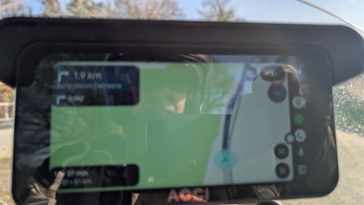
Today I activated the free trial on Next+ and generated and rode a 150km loop. There were some things I liked, some that seem like a matter of taste, and some that I am dubious about. One thing I really liked was the speed limit and current speed. I don't know why but they seemed unusually clear and easy to understand - except when the speed limit was partially covered by an unexplained button marked "Exit", but even then, I still knew if I was over the limit. I also liked the top left Next Turn with the following info below it though I sometimes struggled to read the details though whether that was a problem with the screen, font, resolution or my eyesight is a conversation for another time.
I did not like the behavior when I deviated from the suggested route. Normally, it recalculated within two to five seconds (which is acceptable, but still quite slow compared to some of the competition), my problem was that it was recalculating to get to a point now behind me with no indication on the display of where it wanted to go or how far away it was and no obvious way to skip to next point still ahead of me. I only knew this because it was trying to send me down roads I knew that only had exits behind me. On today's roads, where I knew generally where I was, that was manageable as it would eventually give up and move to the next point on the route. On roads I don't know, I need to know exactly where the app is trying to take me. If there is a setting to show these points, I suggest you turn it on by default and let experienced users turn it off if they don't need it. If you don't have such a setting, please prioritize adding it. Perhaps also consider that the info box with final destination info could be more useful with name, distance and/or time to next navigation point with a small compass arrow indicating relative direction. Some indication of whether it is a stopping point or a shaping point would be useful as would a button to skip it.
On more then one occasion the recalculation got stuck, even on a relatively long road with no turn-offs, the spinning arrow just kept spinning. After five minutes or more, I pressed the unexplained and inconveniently placed "exit" button just to see what would happen. That offered me some text about leaving android auto (huh?) with the choices "No" and "Navigate". I have always thought of myself as a rather intelligent person but when riding a motorbike, it appears that I don't have nearly as much cognitive reserve as I thought I had. The dialog made no sense to me at the time so I pressed a button just to make it go away. The good news was that it recalculated quickly and the bonus was that it made the annoying "Exit" button go away so I could now see with the speed limit was. Bikers have limit to how much they can focus on, if you need to ask them a question, please keep it simple.
I did not like the fact that the displayed route and the map it was displayed on sometimes did not agree with each other. I don't really understand how this could happen. I mean, what is the point of calculating the route against a different map than the one you are displaying? This probably ties in with my next comment.
The point of having a map is to tell you about what is ahead before you can see it for yourself. When the map does not display the other roads in the area then you can't know about junctions, cross roads, loss of right-of-way and any of the other important information that a map is supposed to give you. I know the other roads were on the map because sometimes there were thin strips of pixels that would probably have been the names of the roads if the screen was much larger and of much higher resolution. Perhaps the roads were there and just displayed as white on white, or perhaps the edges of the roads dropped below the pixel resolution of the screen I was using, but the result was the same. Please use better defaults.
The image below shows the route not matching the map, the "Exit" button covering the speed limit and the turn to the right that I could see is not displayed.
I will, weather permitting, do a few more tests with Next+, but at the moment I am not convinced enough to pay for a subscription.
-
I disabled recalculation after the time I took a wrong turn, and it made me go around the mountain to get back on the right path. But even with recalculation disabled, you have to be careful not to take a wrong turn because the app doesn't warn you (with the classic "U-turn as soon as you can"), and if you don't check the display, you risk going miles and miles off course.
If you're taking unfamiliar roads, at every turn or intersection, you have to check the display before and after to make sure you're on the right route; the app is still lacking in this regard. -
Another test and the Here map showed itself to be many years out-of-date showing businesses that have not traded since before covid or simply showing them in the wrong place. Sorry, but I am now convinced that the subscription is not worth it for my needs.
-
Another test and the Here map showed itself to be many years out-of-date showing businesses that have not traded since before covid or simply showing them in the wrong place. Sorry, but I am now convinced that the subscription is not worth it for my needs.
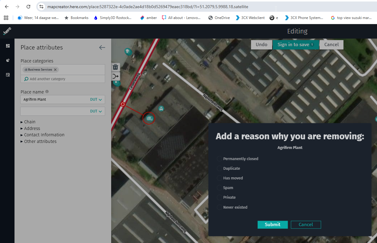
@Paul-Smith-3, you could try to correct it yourself. You don't need to correct all those you encounter, but you could check your own neighborhood to help others once each year. If no one does anything it won't get better. Usually Businesses do not call HERE when they stop or go bankrupt. But of course having critique is much easier...
I am just an enthusiastic MRA user, and hope you will be one too!
Most motorcycle problems are caused by the nut that connects the handlebar to the saddle.
Check out RideSleepRepeat.eu, a biker community for sharing stays across Europe
-
@Paul-Smith-3 : I like to drive the way you want it, as often as I can, you should read the most important thing in the manual.
https://www.myrouteapp.com/support
In the user account then under the menu "Navigation settings / functions" you will find important settings
VG Hubert
Beta Test "Next App" dazu die Hardware .
iPad 9. Gen iOS 26.5.2/ iPhone 16e iOS 26.5.2/ Navi iPhone Xr iOS 18.7.9 / PC mit MS Win11 /❗️MyRoute-App im Cradel und Remotek-One❗️ Info zu MRA & Remotek One -
@Paul-Smith-3 : I like to drive the way you want it, as often as I can, you should read the most important thing in the manual.
https://www.myrouteapp.com/support
In the user account then under the menu "Navigation settings / functions" you will find important settings
@Hubert-Thoring Thank you for treating me like an idiot and politely asking me to RTFM. As a new member with a really low post count your contribution goes a long way towards making me feel like a welcome and valued member of this community. </sarcasm>
Unfortunately, had you been willing to take a moment and actually read my post instead of just posting nonsense to increase your post count, you might have noticed that I mentioned (more than once) a suggestion to change the "DEFAULT" settings. Your "Valued Contributor" tag would earn far more respect had you been able to suggest even one single specific setting that would address any of the many points I raised.
-
@Paul-Smith-3, you could try to correct it yourself. You don't need to correct all those you encounter, but you could check your own neighborhood to help others once each year. If no one does anything it won't get better. Usually Businesses do not call HERE when they stop or go bankrupt. But of course having critique is much easier...
@Con-Hennekens I take your point that the maps are a third party resource and can be improved with volunteer contributions, but how can I be expected to trust the maps for destinations I do not know when I know they are wrong for places I do know?
It forces me to ask whether Here maps are the right choice for MRA to use for navigation.
-
@Hubert-Thoring Thank you for treating me like an idiot and politely asking me to RTFM. As a new member with a really low post count your contribution goes a long way towards making me feel like a welcome and valued member of this community. </sarcasm>
Unfortunately, had you been willing to take a moment and actually read my post instead of just posting nonsense to increase your post count, you might have noticed that I mentioned (more than once) a suggestion to change the "DEFAULT" settings. Your "Valued Contributor" tag would earn far more respect had you been able to suggest even one single specific setting that would address any of the many points I raised.
I just logged in to this forum for the first time in almost a year, and I actually laughed when I read through this thread.
Just search for posts with my username and you'll see that I was very much in the same boat that you are now last year. Obviously nothing has changed.
While doing a three week trip in the spring of 2025 in totally unfamiliar areas, and after spending MANY hours meticulously planning the trip in the online MRA route planner in advance, I experienced numerous MRA navigation issues that I documented to the forum that I took the time to do while on the trip. Not imagined issues.... documented oneswith screenshots and detailed explanations.
When I tried to discuss and understand how to work around these real issues here on the forum, I got the same type of useless responses that you just got from some of the "experienced" contributors. They seemingly didn't really read and/or understand what I was explaining, or they were purposely choosing to ignore it. It was very, very frustrating.
My perception was (and still is) that here on the forum it wasn't / isn't acceptable to post MRA issues or constructive criticism. If you did post an issue then it was assumed that you were either an idiot that couldn't read or comprehend the manual or MRA, or that you were just a complainer. I'm neither.
I finally gave up trying to get useful answers from this forum and used my backup Garmin XT using the .gpx files generated by MRA's route planner to finish the trip without surprises or issues.
I have lifetime subscriptions for all of the MRA products as I do believe in them. I'm very technically inclined and I am very familiar with most of the navigation apps and devices, their advantages and their weaknesses (MRA, Basecamp, Kurviger, multiple Garmin devices, Apple Carplay, DMD) etc.
I, like you, do read the manual thoroughly (which in MRA's case understandably does change constantly and isn't always current). I also personally take offense when someone lazily posts "RTFM" instead of taking the time to read and totally comprehend what I've taken the time to write and offer succinct advice on how to solve my issue.
IMO, this users' forum could, and would be MUCH more useful if the seasoned participants would be much less defensive about MRA's shortcomings, and offer direct, to-the-point help instead of condescending bulls***.
In 1996 (pre-Internet boom by a long shot) I started a technology businesses from the ground up culminating with over 30,000 subscription customers with an SAS business model and exiting with a sale to a global technology company. I'm not a technology rookie.
There's one thing that I learned very early on in my journey.... you can't fix a problem unless you 1) understand it and 2) admit that it's a problem. Ignoring a problem doesn't fix it..... ever!
Here's my recommendation..... If you, as experienced MRA users, wish to help MRA succeed, when a valid issue is raised on the forum your response should be "yes, we recognize that's a problem or limitation, and until it's resolved here's what we do to work around it."
I appreciate and respect that type of honest, intelligent and helpful response! I'm quite sure that others feel the same way!
Experienced MRA forum members that respond to forum posts regarding MRA problems or limitations with totally unhelpful and condescending replies, IMO, are ultimately being detrimental to the future success of MRA, and I'm sure that's not anyone's true intent!
MRA's developers, the program itself, and the MRA users overall are absolutely great. I would not take the time to write this if I didn't believe completely in the people and the product.
That said.... I have no doubt that I'm going to get blasted (again), but that's ok. Life goes on!
")
Steve Jarrell
Western North Carolina USLifetime Routeplanner Gold & Navigation Next
2025 BMW R1200GS
2025 Can-Am Spyder
DMD T865-X 8" Tablet
Garmin XT3 -
I just logged in to this forum for the first time in almost a year, and I actually laughed when I read through this thread.
Just search for posts with my username and you'll see that I was very much in the same boat that you are now last year. Obviously nothing has changed.
While doing a three week trip in the spring of 2025 in totally unfamiliar areas, and after spending MANY hours meticulously planning the trip in the online MRA route planner in advance, I experienced numerous MRA navigation issues that I documented to the forum that I took the time to do while on the trip. Not imagined issues.... documented oneswith screenshots and detailed explanations.
When I tried to discuss and understand how to work around these real issues here on the forum, I got the same type of useless responses that you just got from some of the "experienced" contributors. They seemingly didn't really read and/or understand what I was explaining, or they were purposely choosing to ignore it. It was very, very frustrating.
My perception was (and still is) that here on the forum it wasn't / isn't acceptable to post MRA issues or constructive criticism. If you did post an issue then it was assumed that you were either an idiot that couldn't read or comprehend the manual or MRA, or that you were just a complainer. I'm neither.
I finally gave up trying to get useful answers from this forum and used my backup Garmin XT using the .gpx files generated by MRA's route planner to finish the trip without surprises or issues.
I have lifetime subscriptions for all of the MRA products as I do believe in them. I'm very technically inclined and I am very familiar with most of the navigation apps and devices, their advantages and their weaknesses (MRA, Basecamp, Kurviger, multiple Garmin devices, Apple Carplay, DMD) etc.
I, like you, do read the manual thoroughly (which in MRA's case understandably does change constantly and isn't always current). I also personally take offense when someone lazily posts "RTFM" instead of taking the time to read and totally comprehend what I've taken the time to write and offer succinct advice on how to solve my issue.
IMO, this users' forum could, and would be MUCH more useful if the seasoned participants would be much less defensive about MRA's shortcomings, and offer direct, to-the-point help instead of condescending bulls***.
In 1996 (pre-Internet boom by a long shot) I started a technology businesses from the ground up culminating with over 30,000 subscription customers with an SAS business model and exiting with a sale to a global technology company. I'm not a technology rookie.
There's one thing that I learned very early on in my journey.... you can't fix a problem unless you 1) understand it and 2) admit that it's a problem. Ignoring a problem doesn't fix it..... ever!
Here's my recommendation..... If you, as experienced MRA users, wish to help MRA succeed, when a valid issue is raised on the forum your response should be "yes, we recognize that's a problem or limitation, and until it's resolved here's what we do to work around it."
I appreciate and respect that type of honest, intelligent and helpful response! I'm quite sure that others feel the same way!
Experienced MRA forum members that respond to forum posts regarding MRA problems or limitations with totally unhelpful and condescending replies, IMO, are ultimately being detrimental to the future success of MRA, and I'm sure that's not anyone's true intent!
MRA's developers, the program itself, and the MRA users overall are absolutely great. I would not take the time to write this if I didn't believe completely in the people and the product.
That said.... I have no doubt that I'm going to get blasted (again), but that's ok. Life goes on!
@Steve-Jarrell very, very well said!!
-
@Con-Hennekens I take your point that the maps are a third party resource and can be improved with volunteer contributions, but how can I be expected to trust the maps for destinations I do not know when I know they are wrong for places I do know?
It forces me to ask whether Here maps are the right choice for MRA to use for navigation.
@Paul-Smith-3 said in Next+ 1st impressions:
how can I be expected to trust the maps for destinations I do not know when I know they are wrong for places I do know?
That's a problem for ALL map providers, even the paper ones. Not trusting them by default leads you nowhere (quite literally in this case
") ).
). -
I just logged in to this forum for the first time in almost a year, and I actually laughed when I read through this thread.
Just search for posts with my username and you'll see that I was very much in the same boat that you are now last year. Obviously nothing has changed.
While doing a three week trip in the spring of 2025 in totally unfamiliar areas, and after spending MANY hours meticulously planning the trip in the online MRA route planner in advance, I experienced numerous MRA navigation issues that I documented to the forum that I took the time to do while on the trip. Not imagined issues.... documented oneswith screenshots and detailed explanations.
When I tried to discuss and understand how to work around these real issues here on the forum, I got the same type of useless responses that you just got from some of the "experienced" contributors. They seemingly didn't really read and/or understand what I was explaining, or they were purposely choosing to ignore it. It was very, very frustrating.
My perception was (and still is) that here on the forum it wasn't / isn't acceptable to post MRA issues or constructive criticism. If you did post an issue then it was assumed that you were either an idiot that couldn't read or comprehend the manual or MRA, or that you were just a complainer. I'm neither.
I finally gave up trying to get useful answers from this forum and used my backup Garmin XT using the .gpx files generated by MRA's route planner to finish the trip without surprises or issues.
I have lifetime subscriptions for all of the MRA products as I do believe in them. I'm very technically inclined and I am very familiar with most of the navigation apps and devices, their advantages and their weaknesses (MRA, Basecamp, Kurviger, multiple Garmin devices, Apple Carplay, DMD) etc.
I, like you, do read the manual thoroughly (which in MRA's case understandably does change constantly and isn't always current). I also personally take offense when someone lazily posts "RTFM" instead of taking the time to read and totally comprehend what I've taken the time to write and offer succinct advice on how to solve my issue.
IMO, this users' forum could, and would be MUCH more useful if the seasoned participants would be much less defensive about MRA's shortcomings, and offer direct, to-the-point help instead of condescending bulls***.
In 1996 (pre-Internet boom by a long shot) I started a technology businesses from the ground up culminating with over 30,000 subscription customers with an SAS business model and exiting with a sale to a global technology company. I'm not a technology rookie.
There's one thing that I learned very early on in my journey.... you can't fix a problem unless you 1) understand it and 2) admit that it's a problem. Ignoring a problem doesn't fix it..... ever!
Here's my recommendation..... If you, as experienced MRA users, wish to help MRA succeed, when a valid issue is raised on the forum your response should be "yes, we recognize that's a problem or limitation, and until it's resolved here's what we do to work around it."
I appreciate and respect that type of honest, intelligent and helpful response! I'm quite sure that others feel the same way!
Experienced MRA forum members that respond to forum posts regarding MRA problems or limitations with totally unhelpful and condescending replies, IMO, are ultimately being detrimental to the future success of MRA, and I'm sure that's not anyone's true intent!
MRA's developers, the program itself, and the MRA users overall are absolutely great. I would not take the time to write this if I didn't believe completely in the people and the product.
That said.... I have no doubt that I'm going to get blasted (again), but that's ok. Life goes on!
@Steve-Jarrell said in Next+ 1st impressions:
I have no doubt that I'm going to get blasted (again), but that's ok. Life goes on!
You are blasting yourself and then surprised that you could be blasted back? I do not share your experience, and do find this a community forum where many volunteers as well as developers actually listen and try to help. Just don't expect them to always agree with you.
Like you say: Life goes on. But somehow you felt the need to look back?
-
Anyone involved in software is either a user or a developer.
To the developer, the user is the person who simply doesn’t understand their brilliant ideas and then gets everything wrong.
To the user, the developer is the person who comes up with great things that nobody needs and that often don’t even work.In user-centred development, such as myrouteapp, the developer tries to meet the user’s needs.
This leads to more and more features being implemented.
This results in a growing number of parameters in the programme, the significance of which is often not sufficiently considered and which are frequently used incorrectly.
And even if everything runs smoothly at this level, the map provider steps in and provides inaccurate data, which in turn leads to unexpected changes to the route.
The Google type enters a destination and expects the sat-nav to take them there. They don’t want to think, they just want to arrive.
The myrouteapp type wants to have a pleasant journey and arrive at the end. The journey is the most important thing; the destination is secondary.
Every sat-nav system starts out as Google.
Then there are options to modify the expected route, such as avoiding motorways…
There are various route engines: myrouteapp-Here, TomTom, OSM, Garmin.
These use not only different maps but also route algorithms with different parameters.
MRA stands out because the user/planner can configure these various options themselves.
But in the end, the engine starts up and the sat-nav begins building the route from scratch again. Roadworks, road closures and accidents are taken into account. And suddenly I’m driving round the mountain on the left rather than the right.The only option is to plan the route yourself so that you get where you want to go.
This must then take into account the various maps, route algorithms and known road closures, etc.For a 3,500 km journey through the Alps, I expect a driving time of over 70 hours.
On my trips, the time spent on preparation and planning always exceeds the actual driving time.You felt being called an idiot; that had something to do with the defaults.
There are no defaults in MRA; you get those from Google.
There’s your planning, and then in the navigation app there are presets that are appropriate for your situation and, above all, for your style of planning.
Unfortunately, that takes work – many hours…
This work can be made easier, because there are many experienced people in this forum who have already planned exactly this kind of journey.
But they’re not keen on helping someone who thinks they’ve already done everything right and then complains. Sorry about that.Once you’ve started your planning, feel free to post it here, and there’ll definitely be people here who’ll take a look and help you.
This is a forum for enthusiasts who are passionate about the subject.
And it’s a forum that developers read too. That’s the only way MRA could have become so excellent.
And if something doesn’t work, be honest enough to consider that perhaps you caused it, rather than a bug in the software.
That’s how MRA and Next have become what they are today. Help make it even better.
RTI’m known for plastering the whole screen with stuff, but you started it… :-))
@RainerT said in Next+ 1st impressions:
I’m known for plastering the whole screen with stuff, but you started it… :-))
Haha! Actually at first I thought: TL;DR, but then I saw Nick his upvote and decided to pull through because if Nick upvotes there must be something interesting
. And I agree. -
I have a 3500km trip around the Alps coming up this summer. I want to plan my trip at home on my PC using Basecamp, Google and MyRouteApp. I want to ride the trip exactly as I planned except when I don't. I want to stop for petrol or coffee or follow an interesting detour and still be able to get back on track without needing an advanced computer science degree. I am trying different options to find something that meets my needs.
I tried the old Navigation app in '22 and '23 but eventually gave up on it because it could not handle interruptions gracefully. Even something as simple a stopping for petrol meant the planned route was lost and it took too much rigmarole to get back on track to be worth using. I use or have used Google, Waze, Basecamp, Kurviger, MRA and Garmin. I have an Android phone (Pixel 8Pro) and on my bike I can have a QuadLock, a Garmin and/or an AndroidAuto Display (I currently use an Aooccii C6 Pro).
Today I activated the free trial on Next+ and generated and rode a 150km loop. There were some things I liked, some that seem like a matter of taste, and some that I am dubious about. One thing I really liked was the speed limit and current speed. I don't know why but they seemed unusually clear and easy to understand - except when the speed limit was partially covered by an unexplained button marked "Exit", but even then, I still knew if I was over the limit. I also liked the top left Next Turn with the following info below it though I sometimes struggled to read the details though whether that was a problem with the screen, font, resolution or my eyesight is a conversation for another time.
I did not like the behavior when I deviated from the suggested route. Normally, it recalculated within two to five seconds (which is acceptable, but still quite slow compared to some of the competition), my problem was that it was recalculating to get to a point now behind me with no indication on the display of where it wanted to go or how far away it was and no obvious way to skip to next point still ahead of me. I only knew this because it was trying to send me down roads I knew that only had exits behind me. On today's roads, where I knew generally where I was, that was manageable as it would eventually give up and move to the next point on the route. On roads I don't know, I need to know exactly where the app is trying to take me. If there is a setting to show these points, I suggest you turn it on by default and let experienced users turn it off if they don't need it. If you don't have such a setting, please prioritize adding it. Perhaps also consider that the info box with final destination info could be more useful with name, distance and/or time to next navigation point with a small compass arrow indicating relative direction. Some indication of whether it is a stopping point or a shaping point would be useful as would a button to skip it.
On more then one occasion the recalculation got stuck, even on a relatively long road with no turn-offs, the spinning arrow just kept spinning. After five minutes or more, I pressed the unexplained and inconveniently placed "exit" button just to see what would happen. That offered me some text about leaving android auto (huh?) with the choices "No" and "Navigate". I have always thought of myself as a rather intelligent person but when riding a motorbike, it appears that I don't have nearly as much cognitive reserve as I thought I had. The dialog made no sense to me at the time so I pressed a button just to make it go away. The good news was that it recalculated quickly and the bonus was that it made the annoying "Exit" button go away so I could now see with the speed limit was. Bikers have limit to how much they can focus on, if you need to ask them a question, please keep it simple.
I did not like the fact that the displayed route and the map it was displayed on sometimes did not agree with each other. I don't really understand how this could happen. I mean, what is the point of calculating the route against a different map than the one you are displaying? This probably ties in with my next comment.
The point of having a map is to tell you about what is ahead before you can see it for yourself. When the map does not display the other roads in the area then you can't know about junctions, cross roads, loss of right-of-way and any of the other important information that a map is supposed to give you. I know the other roads were on the map because sometimes there were thin strips of pixels that would probably have been the names of the roads if the screen was much larger and of much higher resolution. Perhaps the roads were there and just displayed as white on white, or perhaps the edges of the roads dropped below the pixel resolution of the screen I was using, but the result was the same. Please use better defaults.
The image below shows the route not matching the map, the "Exit" button covering the speed limit and the turn to the right that I could see is not displayed.
I will, weather permitting, do a few more tests with Next+, but at the moment I am not convinced enough to pay for a subscription.
This post is deleted!
Hello! It looks like you're interested in this conversation, but you don't have an account yet.
Getting fed up of having to scroll through the same posts each visit? When you register for an account, you'll always come back to exactly where you were before, and choose to be notified of new replies (either via email, or push notification). You'll also be able to save bookmarks and upvote posts to show your appreciation to other community members.
With your input, this post could be even better 💗
Register Login-
718159
-
027580
-
0857
-
013329
-
04157
-
04114
-
0379
-
08460